A Swarm of Swimming Robots to Search for Life Under the Ice on Europa

An artist’s interpretation of liquid water on the surface of the Europa pooling beneath chaos terrain. Credit: : NASA/JPL-Caltech

When Galileo pointed his telescope at Jupiter 400 years ago, he saw three blobs of light around the giant planet, which he at first thought were fixed stars. He kept looking, and eventually, he spotted a fourth blob and noticed the blobs were moving. Galileo’s discovery of objects orbiting something other than Earth—which we call the Galilean moons in his honour—struck a blow to the Ptolemaic (geocentric) worldview of the time.

Galileo couldn’t have foreseen the age of space exploration that we’re living in now. Fast forward 400 years, and here we are. We know the Earth doesn’t occupy any central point. We’ve discovered thousands of other planets, and many of them will have their own moons. Galileo would be amazed at this.

What would he think about robotic missions to explore one of the blobs of light he spotted?

Continue reading “A Swarm of Swimming Robots to Search for Life Under the Ice on Europa”

The End is Near: NASA’s MESSENGER Now Running on Fumes

The MESSENGER spacecraft has been in orbit around Mercury since March 2011. Image Credit: NASA/JHU APL/Carnegie Institution of Washington

For more than four years NASA’s MESSENGER spacecraft has been orbiting our solar system’s innermost planet Mercury, mapping its surface and investigating its unique geology and planetary history in unprecedented detail. But the spacecraft has run out of the fuel needed to maintain its extremely elliptical – and now quite low-altitude – orbit, and the Sun will soon set on the mission when MESSENGER makes its fatal final dive into the planet’s surface at the end of the month.

On April 30 MESSENGER will impact Mercury, falling down to its Sun-baked surface and colliding at a velocity of 3.9 kilometers per second, or about 8,700 mph. The 508-kilogram spacecraft will create a new crater on Mercury about 16 meters across.

The impact is estimated to occur at 19:25 UTC, which will be 3:25 p.m. at the John Hopkins University Applied Physics Lab in Laurel, Maryland, where the MESSENGER operations team is located. Because the spacecraft will be on the opposite side of Mercury as seen from Earth the impact site will not be in view.

Postcards from the (Inner) Edge: MESSENGER Images of Mercury

MESSENGER captures image of curious "hollows" around a crater peak
MESSENGER image of “hollows” around a crater’s central peak – one of the many unique discoveries the mission made about Mercury. Read more here.

But while it’s always sad to lose a dutiful robotic explorer like MESSENGER, its end is bittersweet; the mission has been more than successful, answering many of our long-standing questions about Mercury and revealing features of the planet that nobody even knew existed. The data MESSENGER has returned to Earth – over ten terabytes of it – will be used by planetary scientists for decades in their research on the formation of Mercury as well as the Solar System as a whole.

“For the first time in history we now have real knowledge about the planet Mercury that shows it to be a fascinating world as part of our diverse solar system,” said John Grunsfeld, associate administrator for NASA’s Science Mission Directorate. “While spacecraft operations will end, we are celebrating MESSENGER as more than a successful mission. It’s the beginning of a longer journey to analyze the data that reveals all the scientific mysteries of Mercury.”

View the top ten science discoveries from MESSENGER here.

On April 6 MESSENGER used up the last vestiges of the liquid hydrazine propellant in its tanks, which it needed to make course corrections to maintain its orbit. But the tanks also hold gaseous helium as a pressurizer, and system engineers figured out how to release that gas through the complex hydrazine nozzles and keep MESSENGER in orbit for a few more weeks.

Earth and the Moon imaged by the MESSENGER spacecraft on Oct. 8, 2014
Earth and the Moon imaged by MESSENGER on Oct. 8, 2014. Credit: NASA/JHU APL/Carnegie Institution of Washington.

On April 24, though, even those traces of helium will be exhausted after a sixth and final orbit correction maneuver. From that point on MESSENGER will be coasting – out of fuel, out of fumes, and out of time.

“Following this last maneuver, we will finally declare MESSENGER out of propellant, as this maneuver will deplete nearly all of our remaining helium gas,” said Mission Systems Engineer Daniel O’Shaughnessy. “At that point, the spacecraft will no longer be capable of fighting the downward push of the Sun’s gravity.

“After studying the planet intently for more than four years, MESSENGER’s final act will be to leave an indelible mark on Mercury, as the spacecraft heads down to an inevitable surface impact.”

Read more: Five Mercury Secrets Revealed by MESSENGER

But MESSENGER scientists and engineers can be proud of the spacecraft that they built, which has proven itself more than capable of operating in the inherently challenging environment so close to our Sun.

“MESSENGER had to survive heating from the Sun, heating from the dayside of Mercury, and the harsh radiation environment in the inner heliosphere, and the clearest demonstration that our innovative engineers were up to the task has been the spacecraft’s longevity in one of the toughest neighborhoods in our Solar System,” said MESSENGER Principal Investigator Sean Solomon. “Moreover, all of the instruments that we selected nearly two decades ago have proven their worth and have yielded an amazing series of discoveries about the innermost planet.”

True color image of Mercury (MESSENGER)
True-color image of Mercury made from MESSENGER data. Credit: NASA/JHU APL/Carnegie Institution of Washington.

The MESSENGER (MErcury Surface, Space ENvironment, GEochemistry, and Ranging) spacecraft launched on August 3, 2004, and traveled over six and a half years before entering orbit about Mercury on March 18, 2011 – the first spacecraft ever to do so. Learn more about the mission’s many discoveries here.

The video below was released in 2013 to commemorate MESSENGER’s second year in orbit and highlights some of the missions important achievements.

Source: NASA and JHUAPL

Are you an educator? Check out some teaching materials and shareables on the MESSENGER community page here.

SpaceX Could Launch 17 Rockets in 2015, Including the Most Powerful Rocket Since Saturn V

With over 3.8 million pounds of thrust at liftoff, Falcon Heavy will be the most capable rocket flying. By comparison, the liftoff thrust of the Falcon Heavy equals fifteen Boeing 747 aircraft at full power. Credit: SpaceX

If all goes as hoped, SpaceX will have a very busy 2015. The commercial space company could launch as many as 17 rockets, including a mid-flight test abort of the Dragon capsule to demonstrate its in-flight crew escape system. Then there’s the launch that every rocket aficionado one has been waiting for: the demonstration mission of the 27-engine Falcon Heavy rocket.

Already, SpaceX has launched one mission in 2015, the CRS-5 Dragon resupply mission for the International Space Station that was delayed from December 2014. In addition to successfully hooking up with the ISS, SpaceX also tested out a flyback and landing system for the Falcon 9 first stage, which was deemed “mostly successful” despite a spectacular explosion when it careened off the target, a floating ocean barge. The next test of the landing system will occur with the launch of the solar wind monitoring DSCOVR satellite, which has just been delayed slightly to February 9.

While SpaceX itself does not list upcoming launch dates on its own website, a site put together by SpaceX enthusiast Lukas Davia called SpaceXStats has garnered a list of potential launch dates from NASA and other customers, and they say up to 16 more launches could take place this year. SpaceX will be launching more space station resupply missions, commercial satellite launch missions, and US government science and national security missions.

Delays like the recently announced launch delay for DSCOVR, will greatly impact how many launches SpaceX will be able to conduct this year. Musk has said his company could launch about one rocket per month during 2015, while other sources predict 10-12 launches for the commercial company.

A SpaceX Falcon 9 rocket carrying a Dragon cargo capsule packed with science experiments and station supplies blasts off from Space Launch Complex 40 at Cape Canaveral Air Force Station, Florida, on Sept. 21, 2014 bound for the ISS.  Credit: Ken Kremer/kenkremer.com
A SpaceX Falcon 9 rocket carrying a Dragon cargo capsule packed with science experiments and station supplies blasts off from Space Launch Complex 40 at Cape Canaveral Air Force Station, Florida, on Sept. 21, 2014 bound for the ISS. Credit: Ken Kremer/kenkremer.com

As reported in Spaceflightnow.com, SpaceX had a similar number of flights on its docket in 2014, including the Falcon Heavy’s debut launch and the Dragon abort tests, which has slipped to be on the launch manifest for 2015. Six Falcon 9 rockets ended up blasting off last year.

Most of the missions will take off from Cape Canaveral’s launch complex, where up to 24 launches could take place this year. Along with the launches from SpaceX, United Launch Alliance has launches schedule for satellites for the U.S. military, NASA and commercial companies.

Video: Falcon Heavy

The Falcon Heavy was originally scheduled for its first test flight in late 2012 or early 2013 from Vandenberg Air Force Base, California, but it now will launch from the refurbished pads at Cape Canaveral. SpaceX says this rocket was designed from the outset to carry humans into space and “restores the possibility of flying missions with crew to the Moon or Mars.”

The Falcon Heavy will lift over 53 metric tons (117,000 lb) to orbit, about three times the performance of the Falcon 9. It is comprised of three nine-engine Falcon 9 first stage booster cores and uses upgraded Merlin 1D engines.

Here’s a sampling of launches from SpaceXStats, see the full list here.

9 Feb 2015 DSCOVR NOAA Falcon 9 v1.1 SLC-40, Florida
17 Feb 2015 Eutelsat 115W B & ABS-3A Asia Broadcast Satellite Falcon 9 v1.1 SLC-40, Florida
March 2015 Dragon Inflight Abort SpaceX / NASA Falcon 9 v1.1 SLC-4E, Vandenberg, California
8 Apr 2015 SpaceX CRS-6 NASA Falcon 9 v1.1 SLC-40, Florida
H1 2015 Falcon Heavy Test Flight SpaceX Falcon Heavy LC-39A, Florida

Video: SpaceX’s Year in Review, 2014:

Making the Trip to Mars Cheaper and Easier: The Case for Ballistic Capture

How long does it take to get to Mars
A new proposal for sending craft to Mars could save money and offer more flexible launch windows. Credit: NASA

When sending spacecraft to Mars, the current, preferred method involves shooting spacecraft towards Mars at full-speed, then performing a braking maneuver once the ship is close enough to slow it down and bring it into orbit.

Known as the “Hohmann Transfer” method, this type of maneuver is known to be effective. But it is also quite expensive and relies very heavily on timing. Hence why a new idea is being proposed which would involve sending the spacecraft out ahead of Mars’ orbital path and then waiting for Mars to come on by and scoop it up.

This is what is known as “Ballistic Capture”, a new technique proposed by Professor Francesco Topputo of the Polytechnic Institute of Milan and Edward Belbruno, a visiting associated researcher at Princeton University and former member of NASA’s Jet Propulsion Laboratory.

In their research paper, which was published in arXiv Astrophysics in late October, they outlined the benefits of this method versus traditional ones. In addition to cutting fuel costs, ballistic capture would also provide some flexibility when it comes to launch windows.

MAVEN was launched into a Hohmann Transfer Orbit with periapsis at Earth's orbit and apoapsis at the distance of the orbit of Mars. Credit: NASA
MAVEN was launched into a Hohmann Transfer Orbit with periapsis at Earth’s orbit and apoapsis at the distance of the orbit of Mars. Credit: NASA

Currently, launches between Earth and Mars are limited to period where the rotation between the two planets is just right. Miss this window, and you have to wait another 26 months for a new one to come along.

At the same time, sending a rocket into space, through the vast gulf that separates Earth’s and Mars’ orbit, and then firing thrusters in the opposite direction to slow down, requires a great deal of fuel. This in turn means that the spacecraft responsible for transporting satellites, rovers, and (one day) astronauts need to be larger and more complicated, and hence more expensive.

As Belbruno told Universe Today via email:  “This new class of transfers is very promising for giving a new approach to future Mars missions that should lower cost and risk.  This new class of transfers should be applicable to all the planets. This should give all sorts of new possibilities for missions.”

The idea was first proposed by Belbruno while he was working for JPL, where he was trying to come up with numerical models for low-energy trajectories. “I first came up with the idea of ballistic capture in early 1986 when working on a JPL study called LGAS (Lunar Get Away Special),” he said. “This study involved putting a tiny 100 kg solar electric spacecraft in orbit around the Moon that was first ejected from a Get Away Special Canister on the Space Shuttle.”

The Hiten spacecraft, part of the MUSES Program, was built by the Institute of Space and Astronautical Science of Japan and launched on January 24, 1990. It was Japan's first lunar probe. Credit: JAXA
The Hiten spacecraft, built by the Institute of Space and Astronautical Science of Japan, was Japan’s first lunar probe. Credit: JAXA

The test of the LGAS was not a resounding success, as it would be two years before it got to the Moon. But in 1990, when Japan was looking to rescue their failed lunar orbiter, Hiten, he submitted proposals for a ballistic capture attempt that were quickly incorporated into the mission.

“The time of flight for this one was 5 months,” he said. “It was successfully used in 1991 to get Hiten to the Moon.” And since that time, the LGAS design has been used for other lunar missions, including the ESA’s SMART-1 mission in 2004 and NASA’s GRAIL mission in 2011.

But it is in future missions, which involve much greater distances and expenditures of fuel, that Belbruno felt would most benefit from this method. Unfortunately, the idea met with some resistance, as no missions appeared well-suited to the technique.

“Ever since 1991 when Japan’s Hiten used the new ballistic capture transfer to the Moon, it was felt that finding a useful one for Mars was not possible due to Mars much longer distance and its high orbital velocity about the Sun. However, I was able to find one in early 2014 with my colleague Francesco Topputo.”

Artist's impression of India’s Mars Orbiter Mission (MOM). Credit: ISRO
India’s Mars Orbiter Mission (MOM) was one of the most successful examples of the Hohmann Transfer method. Credit: ISRO

Granted, there are some drawbacks to the new method. For one, a spacecraft sent out ahead of Mars’ orbital path would take longer to get into orbit than one that slows itself down to establish orbit.

In addition, the Hohmann Transfer method is a time-tested and reliable one. One of the most successful applications of this maneuver took place back in September, when the Mars Orbiter Mission (MOM) made its historic orbit around the Red Planet. This not only constituted the first time an Asian nation reached Mars, it was also the first time that any space agency had achieved a Mars orbit on the first try.

Nevertheless, the possibilities for improvements over the current method of sending craft to Mars has people at NASA excited. As James Green, director of NASA’s Planetary Science Division, said in an interview with Scientific American: “It’s an eye-opener. This [ballistic capture technique] could not only apply here to the robotic end of it but also the human exploration end.”

Don’t be surprised then if upcoming missions to Mars or the outer Solar System are performed with greater flexibility, and on a tighter budget.

Further Reading: arXiv Astrophysics

ESA’s Gaia Mission Launches to Map the Milky Way

Soyuz VS06, with Gaia space observatory, lifted off from Europe's Spaceport, French Guiana, on 19 December 2013. (ESA–S. Corvaja)

Early this morning, at 09:12 UTC, the cloudy pre-dawn sky above the coastal town of Kourou, French Guiana was brilliantly sliced by the fiery exhaust of a Soyuz VS06, which ferried ESA’s “billion-star surveyor” Gaia into space to begin its five-year mission to map the Milky Way.

Ten minutes after launch, after separation of the first three stages, the Fregat upper stage ignited, successfully delivering Gaia into a temporary parking orbit at an altitude of 175 km (108 miles). A second firing of the Fregat 11 minutes later took Gaia into its transfer orbit, followed by separation from the upper stage 42 minutes after liftoff. 46 minutes later Gaia’s sunshield was deployed, and the spacecraft is now cruising towards its target orbit around L2, a gravitationally-stable point in space located 1.5 million km (932,000 miles) away in the “shadow” of the Earth.

The launch itself was really quite beautiful, due in no small part to the large puffy clouds over the launch site. Watch the video below:

A global space astrometry mission, Gaia will make the largest, most precise three-dimensional map of our galaxy by surveying more than a billion stars over a five-year period.

“Gaia promises to build on the legacy of ESA’s first star-mapping mission, Hipparcos, launched in 1989, to reveal the history of the galaxy in which we live,” says Jean-Jacques Dordain, ESA’s Director General.

Soyuz VS06, with Gaia, lifted off from French Guiana, 19 December 2013. (ESA - S. Corvaja)
Soyuz VS06 with Gaia (ESA – S. Corvaja, 2013)

Repeatedly scanning the sky, Gaia will observe each of the billion stars an average of 70 times each over the five years. (That’s 40 million observations every day!) It will measure the position and key physical properties of each star, including its brightness, temperature and chemical composition.

By taking advantage of the slight change in perspective that occurs as Gaia orbits the Sun during a year, it will measure the stars’ distances and, by watching them patiently over the whole mission, their motions across the sky.

The motions of the stars can be put into “rewind” to learn more about where they came from and how the Milky Way was assembled over billions of years from the merging of smaller galaxies, and into “fast forward” to learn more about its ultimate fate.

“Gaia represents a dream of astronomers throughout history, right back to the pioneering observations of the ancient Greek astronomer Hipparchus, who catalogued the relative positions of around a thousand stars with only naked-eye observations and simple geometry. Over 2,000 years later, Gaia will not only produce an unrivaled stellar census, but along the way has the potential to uncover new asteroids, planets and dying stars.”

– Alvaro Giménez, ESA’s Director of Science and Robotic Exploration

Gaia will make an accurate map of the stars within the Milky Way from its location at L2 (ESA/ATG medialab; background: ESO/S. Brunier)
Gaia will make an accurate map of a billion stars within the Milky Way from its location at L2 (ESA/ATG medialab; background: ESO/S. Brunier)

Of the one billion stars Gaia will observe, 99% have never had their distances measured accurately. The mission will also study 500,000 distant quasars, search for exoplanets and brown dwarfs, and will conduct tests of Einstein’s General Theory of Relativity.

“Along with tens of thousands of other celestial and planetary objects,” said ESA’s Gaia project scientist Timo Prusti, “this vast treasure trove will give us a new view of our cosmic neighbourhood and its history, allowing us to explore the fundamental properties of our Solar System and the Milky Way, and our place in the wider Universe.”

Follow the status of Gaia on the mission blog here.

Source: ESA press release and Gaia fact sheet

Gaia's launch aboard an Arianespace-operated Soyuz on Dec. 19, 2013 from ESA's facility in French Guiana (ESA)
Gaia’s launch aboard an Arianespace-operated Soyuz on Dec. 19, 2013 from ESA’s facility in French Guiana (ESA)

An Unexpected Ending for Deep Impact

Comet Tempel 1 a minute after being struck by Deep Impact's impactor on July 4, 2005 (NASA/JPL-Caltech/UMD)

After almost 9 years in space that included an unprecedented July 4th impact and subsequent flyby of a comet, an additional comet flyby, and the return of approximately 500,000 images of celestial objects, NASA’s Deep Impact/EPOXI mission has officially been brought to a close.

The project team at NASA’s Jet Propulsion Laboratory has reluctantly pronounced the mission at an end after being unable to communicate with the spacecraft for over a month. The last communication with the probe was Aug. 8. Deep Impact was history’s most traveled comet research mission, having journeyed a total of about 4.7 billion miles (7.58 billion kilometers).

“Deep Impact has been a fantastic, long-lasting spacecraft that has produced far more data than we had planned,” said Mike A’Hearn, the Deep Impact principal investigator at the University of Maryland in College Park. “It has revolutionized our understanding of comets and their activity.”

Artist's rendering of the Deep Impactor flyby spacecraft (NASA)
Artist’s rendering of the Deep Impactor flyby spacecraft (NASA)

Launched in January 2005, the spacecraft first traveled about 268 million miles (431 million kilometers) to the vicinity of comet Tempel 1. On July 3, 2005, the spacecraft deployed an impactor into the path of comet to essentially be run over by its nucleus on July 4. This caused material from below the comet’s surface to be blasted out into space where it could be examined by the telescopes and instrumentation of the flyby spacecraft.  Sixteen days after that comet encounter, the Deep Impact team placed the spacecraft on a trajectory to fly back past Earth in late December 2007 to put it on course to encounter another comet, Hartley 2 in November 2010, thus beginning the spacecraft’s new EPOXI mission.

“Six months after launch, this spacecraft had already completed its planned mission to study comet Tempel 1,” said Tim Larson, project manager of Deep Impact at JPL. “But the science team kept finding interesting things to do, and through the ingenuity of our mission team and navigators and support of NASA’s Discovery Program, this spacecraft kept it up for more than eight years, producing amazing results all along the way.”

The spacecraft’s extended mission culminated in the successful flyby of comet Hartley 2 on Nov. 4, 2010. Along the way, it also observed six different stars to confirm the motion of planets orbiting them, and took images and data of the Earth, the Moon and Mars. These data helped to confirm the existence of water on the Moon, and attempted to confirm the methane signature in the atmosphere of Mars.  One sequence of images is a breathtaking view of the Moon transiting across the face of Earth.

This image of comet ISON C/2012 S1 from NASA’s Deep Impact/EPOXI  spacecraft clearly shows the coma and nucleus on Jan. 17 and 18, 2013 beyond the orbit of Jupiter. Credit: NASA.
This image of comet ISON C/2012 S1 from NASA’s Deep Impact/EPOXI spacecraft clearly shows the coma and nucleus on Jan. 17 and 18, 2013 beyond the orbit of Jupiter. Credit: NASA.

The spacecraft’s extended mission culminated in the successful flyby of comet Hartley 2 on Nov. 4, 2010. In January 2012, Deep Impact performed imaging and accessed the composition of distant comet C/2009 P1 (Garradd).

It took images of comet ISON this year and collected early images of comet ISON in June.

After losing contact with the spacecraft last month, mission controllers spent several weeks trying to uplink commands to reactivate its onboard systems. Although the exact cause of the loss is not known, analysis has uncovered a potential problem with computer time tagging that could have led to loss of control for Deep Impact’s orientation. That would then affect the positioning of its radio antennas, making communication difficult, as well as its solar arrays, which would in turn prevent the spacecraft from getting power and allow cold temperatures to ruin onboard equipment, essentially freezing its battery and propulsion systems.

Without battery power, the Deep Impact spacecraft is now adrift and silent, spinning out of control through the solar system.

Launch of Deep Impact aboard a Boeing Delta II from Cape Canaveral AFB on Jan. 12, 2005 (NASA)
Launch of Deep Impact aboard a Boeing Delta II rocket from Cape Canaveral AFS on Jan. 12, 2005 (NASA)

“Despite this unexpected final curtain call, Deep Impact already achieved much more than ever was envisioned. Deep Impact has completely overturned what we thought we knew about comets and also provided a treasure trove of additional planetary science that will be the source data of research for years to come.”

– Lindley Johnson, Program Executive for the Deep Impact mission

It’s a sad end for a hardworking spacecraft, but over the course of its 8 1/2 years in space Deep Impact provided many significant results for the science community. Here are the top five, according to the mission’s principal investigator Michael A’Hearn.

Read more about the Deep Impact mission here.

Source: NASA press release

Endgame: GRAIL Spacecraft to Slam into Lunar Crater Rim on December 17

The GRAIL mission will come to a dramatic end on Monday as the two spacecraft will be commanded to crash into the rim of an unnamed crater near the Moon’s north pole. This is all according to plan, as the two spacecraft are running out of fuel after being in lunar orbit since New Year’s Day 2012.

“We successfully completed our primary science mission,” said Principal Investigator Maria Zuber, “ and, frankly, in my wildest dreams I don’t think this mission could have gone any better than it has. But when you orbit a planetary body that has lumpy gravity field, you use a lot of fuel.”

On Dec. 17 at about 5:28 EST, the spacecraft dubbed Ebb will undergo a controlled impact into a 2 km high “mountain, a rim of a crater that has been buried in ejecta near north pole of the Moon (coordinates are 75.62°N, 26.63°W). About 30 seconds later Flow will impact, about 40 km apart.

Both spacecraft will hit the surface at 3,760 mph (1.7 kilometers per second). No imagery of the impact is expected because the region will be in shadow at the time.

These maps of Earth’s moon highlight the region where the twin spacecraft of NASA’s Gravity Recovery and Interior Laboratory (GRAIL) mission will impact on Dec. Image credit: NASA/GSFC

Additionally, Gruber said that while they hope the Lunar Reconnaissance Orbiter will be able to observe the impact region (at the very least image the region both before and after impact), they don’t expect to there to be a “flash” visible from Earth, and do not believe there will be a significant chance of doing science by kicking up volatiles like LCROSS did, mostly because of the GRAIL spacecraft small size (each about the size of a washing machine) and because of the low angle of impact. The spacecraft have been at a low orbit averaging about 11 km above the surface this week, to be able to map at a high resolution before the fuel ran out.

They chose a mountain-side “since we’re coming in at angle of 1.5 degrees, it would only have left “skid marks” on level surface,” Zuber said. “There was interest in the team in impacting a structure, or a wall, so we could learn about mechanical properties of a crater rim. We’ll be looking at the rim of the crater and understanding how much is intact rock and how much is broken up. It will be very low probability but high scientific payoff if it works, if any volatiles they would be liberated from the impacts.”

The twist on this observation, Zuber said, is this crater is in sunlight most of the time, so if any volatiles come out, it would be surprising.

GRAIL project manager David Lehman said that Friday morning (December 14) the spacecraft will each be executing a maneuver will targeting the impact site, that will also position them to avoid what are called “historic heritage sites,” where the US and Russians have put soft landers on the Moon.

Then they’ll turn off the science instruments, followed by a series of engineering demonstrations to help with future missions over the weekend. About 54 minutes before impact, they’ll burn the remaining fuel to complete the last maneuver.

Lehman said there is a bit of challenge in hitting the crater rim. “We need to clear a ridge and then keep from going through a gap in the rim, because otherwise it would keep going and hit the far side of the Moon.”

Lehman added he was sad to see the mission end. “I’m kind of hoping tonight that a gas station will pull up to our spacecraft and refuel it.”

During their prime mission, from March through May, Ebb and Flow collected data while orbiting at an average altitude of 34 miles (55 kilometers). Their altitude was lowered to 14 miles (23 kilometers) for their extended mission, which began Aug. 30 and sometimes placed them within a few miles of the moon’s tallest surface features.

The duo’s successful prime and extended science missions generated the highest-resolution gravity field map of any celestial body. The map will provide a better understanding of how Earth and other rocky planets in the solar system formed and evolved.

“It is going to be difficult to say goodbye,” said Zuber. “Our little robotic twins have been exemplary members of the GRAIL family, and planetary science has advanced in a major way because of their contributions.”

Curiosity Finds Evidence of An Ancient Streambed on Mars

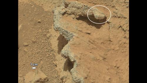
NASA’s Curiosity rover found evidence for an ancient, flowing stream on Mars at a few sites, including the rock outcrop pictured here, which the science team has named “Hottah” after Hottah Lake in Canada’s Northwest Territories. Credit: NASA/JPL/Caltech

The Curiosity rover has come across a place in Gale Crater where ankle-to-hip-deep water once vigorously flowed: an ancient streambed containing evidence of gravel that has been worn by water. At a press briefing today, members of the Mars Science Laboratory team said the rover has found “surprising” outcrops and gravel near the rover landing site that indicate water once flowed in this region, and likely flowed for a long time.

“Too many things that point away from a single burst event,” said Curiosity science co-investigator William Dietrich of the University of California, Berkeley. “I’m comfortable to argue that it is beyond the 1,000 year timescales, even though this is very early on in our findings.”

This set of images compares the Link outcrop of rocks on Mars (left) with similar rocks seen on Earth (right). Credit: NASA/JPL/Caltech

From the size of gravel found by the rover, the science team can interpret the water was moving about 1 meter (3 feet) per second, with a depth somewhere between ankle and hip deep.

“Plenty of papers have been written about channels on Mars with many different hypotheses about the flows in them,” said Dietrich. “This is the first time we’re actually seeing water-transported gravel on Mars. This is a transition from speculation about the size of streambed material to direct observation of it.”

What Curiosity found on Mars was described as conglomerate rock made up of water-transported gravels, meaning the gravel is now cemented into a layers of rock, and the sizes and shapes of stones offer clues to the speed and distance of a long-ago stream’s flow.

“The shapes tell you they were transported and the sizes tell you they couldn’t be transported by wind. They were transported by water flow,” said Curiosity science co-investigator Rebecca Williams of the Planetary Science Institute.

The discovery comes from examining two outcrops, called “Hottah” and “Link,” with the telephoto capability of Curiosity’s mast camera during the first 40 days after landing. Those observations followed up on earlier hints from another outcrop, named Goulburn, which was exposed by thruster exhaust as Curiosity touched down.

“Hottah looks like someone jack-hammered up a slab of city sidewalk, but it’s really a tilted block of an ancient streambed,” said Mars Science Laboratory Project Scientist John Grotzinger of the California Institute of Technology.

An alluvial fan, or fan-shaped deposit where debris spreads out downslope are usually formed by water, and new observations from Curiosity of rounded pebbles embedded with rocky outcrops provide concrete evidence that water did flow in this region on Mars. Elevation data were obtained from stereo processing of images from the High Resolution Imaging Science Experiment (HiRISE) camera on NASA’s Mars Reconnaissance Orbiter. Image credit: NASA/JPL-Caltech/UofA

Even though the team classified the finding as “surprising,” they later said they actually weren’t too surprised at what they found so early in the mission – just 51 sols, or Martian days, in.

“We are getting better about integrating the orbital data,” said Grotzinger. “We see an alluvial fan and debris flow from orbit, and then see these water-transported pebbles from the ground. This is not rocket science, but shows exactly the reason we chose this landing site, and you build on those foundations you think you are mostly likely to establish. Now we’ll look at more rocks and get more context to recreate the environment in greater detail along with understanding the chemistry of the time to see if this is a place that could be habitable.”

Asked if it was hard to come to consensus on this long-term, quickly flowing water statement, given the large number of scientists involved with the mission, Grotziner said, “Given the evidence we have from orbit that has been analyzed, when we arrive with a robot we can test the hypothesis pretty quickly. If the geological signal for this process is large enough, it is easy to achieve a consensus pretty quickly.”

The finding site lies between the north rim of Gale Crater and the base of Aeolis Mons, or Mount Sharp, a mountain inside the crater. To the north of the crater, a channel named Peace Vallis feeds into the alluvial fan. The abundance of channels in the fan between the rim and conglomerate suggests flows continued or repeated over a long time, not just once or for a few years, the science team said.

But interestingly, the rover has already moved on from this spot, and yesterday took the longest drive yet, of between 52-53 meters, heading towards the Glenelg region where they want to do their first scooping and tests soil samples in Curiosity’s two instruments, SAM (Sample Analysis at Mars) and ChemMin (Chemistry & Mineralogy X-Ray Diffraction/X-Ray Fluorescence Instrument). These two experiments will study powdered rock and soil samples scooped up by the robotic arm.

The Glenelg area marks the intersection of three kinds of terrain: bedrock for drilling, several small craters that may represent an older or harder surface, and also terrain similar to where Curiosity landed, so the science team can do comparisons.

“A long-flowing stream can be a habitable environment,” said Grotzinger. “But it is not our top choice as there might be other places that have preserved organic carbon better than this, and we need to assess the potential for preservation of organics. We’re still going to Mount Sharp, but this is insurance that we have already found our first potentially habitable environment.”

The slope of Aeolis Mons contains clay and sulfate minerals, which have been detected from orbit. This can be good preservers of carbon-based organic chemicals that are potential ingredients for life.

As for what’s next for Curiosity, Grotzinger said they have a couple of targets in the next 2-4 sols, and then they will park for a long period of time, about 2-3 weeks to prepare for reaching Glenelg. “This is such a complex set of processes that have never been done on Mars before, so we are going to be conservative and go slowly to make sure everything is working as it should. Then we’ll go to Glenelg and choose first candidate for drilling.”

This map shows the path on Mars of NASA’s Curiosity rover toward Glenelg. Credit: NASA/JPL/Caltech/University of Arizona

Sources: Press briefing, NASA press release

NuSTAR Successfully Deploys Huge Mast

Nine days after launch — and right on schedule — the newest space mission has deployed its unique mast, giving it the ability to see the highest energy X-rays in our universe. The Nuclear Spectroscopic Telescope Array, or NuSTAR, successfully deployed its lengthy 10-meter (33-foot) mast on June 21, and mission scientists say they are one step closer to beginning its hunt for black holes hiding in our Milky Way and other galaxies.

“It’s a real pleasure to know that the mast, an accomplished feat of engineering, is now in its final position,” said Yunjin Kim, the NuSTAR project manager at the Jet Propulsion Laboratory. Kim was also the project manager for the Shuttle Radar Topography Mission, which flew a similar mast on the Space Shuttle Endeavor in 2000 and made topographic maps of Earth.

NuSTAR will search out the most elusive and most energetic black holes, to help in our understanding of the structure of the universe.

NuSTAR has many innovative technologies to allow the telescope to take the first-ever crisp images of high-energy X-ray, and the long mast separates the telescope mirrors from the detectors, providing the distance needed to focus the X-rays.

This is the first deployable mast ever used on a space telescope; the mast was folded up in a small canister during launch.

At 10:43 a.m. PDT (1:43 p.m. EDT) engineers at NuSTAR’s mission control at UC Berkeley in California sent a signal to the spacecraft to start extending the mast, a stable, rigid structure consisting of 56 cube-shaped units. Driven by a motor, the mast steadily inched out of a canister as each cube was assembled one by one. The process took about 26 minutes. Engineers and astronomers cheered seconds after they received word from the spacecraft that the mast was fully deployed and secure.

The NuSTAR team will now begin to verify the pointing and motion capabilities of the satellite, and fine-tune the alignment of the mast. In about five days, the team will instruct NuSTAR to take its “first light” pictures, which are used to calibrate the telescope.
Less than 20 days later, science operations are scheduled to begin.

“With its unprecedented spatial and spectral resolution to the previously poorly explored hard X-ray region of the electromagnetic spectrum, NuSTAR will open a new window on the universe and will provide complementary data to NASA’s larger missions, including Fermi, Chandra, Hubble and Spitzer,” said Paul Hertz, NASA’s Astrophysics Division Director.

NuSTAR launched on an Orbital Science Corporation’s Pegasus rocket, which was dropped from a carrier plane, the L-1011 “Stargazer,” also from Orbital.

Lead image caption: Artist’s concept of NuSTAR in orbit. NuSTAR has a 33-foot (10-meter) mast that deploys after launch to separate the optics modules (right) from the detectors in the focal plane (left). Image credit: NASA/JPL-Caltech

Source: JPL

The End Of Envisat

After ten years in orbit Envisat's mission has been declared over. (ESA)

[/caption]

Well, it’s official. After ten years of groundbreaking observation of our planet, ESA has declared the end of the Envisat mission after losing contact with the satellite on April 8, 2012. All attempts to re-establish communication with Envisat have so far been unsuccessful, and although recovery teams will continue to determine the cause of signal loss and try to regain a signal over the next several weeks, the mission — and the satellite — have been retired.

Having performed twice as long as originally planned, the hardworking Envisat has definitely earned its rest.

On April 8, the European Space Agency lost communication with the Earth-observation satellite, preventing reception of data as it passed over the Kiruna station in Sweden. Although later confirmed that the satellite is still in orbit, the recovery team has not been able to re-establish contact.

It’s thought that a loss of a power regulator could be blocking telemetry and telecommands from reaching Envisat, or else the satellite may have experienced a short-circuit and attempted to go into “safe mode” but experienced difficulties during the transition, leaving it in an unknown state.

Read: Is This the Last Image From Envisat?

ESA states that the chances of ever regaining communication with Envisat are extremely low.

While we had reported before on the last image received before falling silent, the image below is actually the final image from Envisat, an X-band image of the Canary Islands.

The final image from Envisat, acquired on April 8, 2012. (ESA/Edisoft)

During its lifetime, Envisat completed 50,000 orbits of Earth and returned over a thousand terabytes of data, containing invaluable measurements of our planet’s surface and atmosphere that were used in more than 2500 science publications.

The video below gives a fitting eulogy for a satellite that’s definitely overachieved and over-performed, giving us a decade of crucial observations of our world from orbit.

Read more on the ESA news release here.