Is it Friday already? Then it’s time for another Weekly Space Hangout. Join a team of dedicated space journalists to discuss the big space and astronomy news stories that broke this week. This time around, we discussed Amy Shira Teitel’s Buran article, ISON Watch 2013, and the re-re-discovery of water on Mars.
We record the Weekly Space Hangout every Friday at 12:00 pm Pacific / 3:00 pm Eastern, 2000 GMT. You can watch from here on Universe Today, or over on Google+ or YouTube.
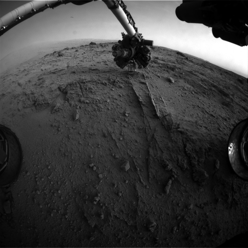
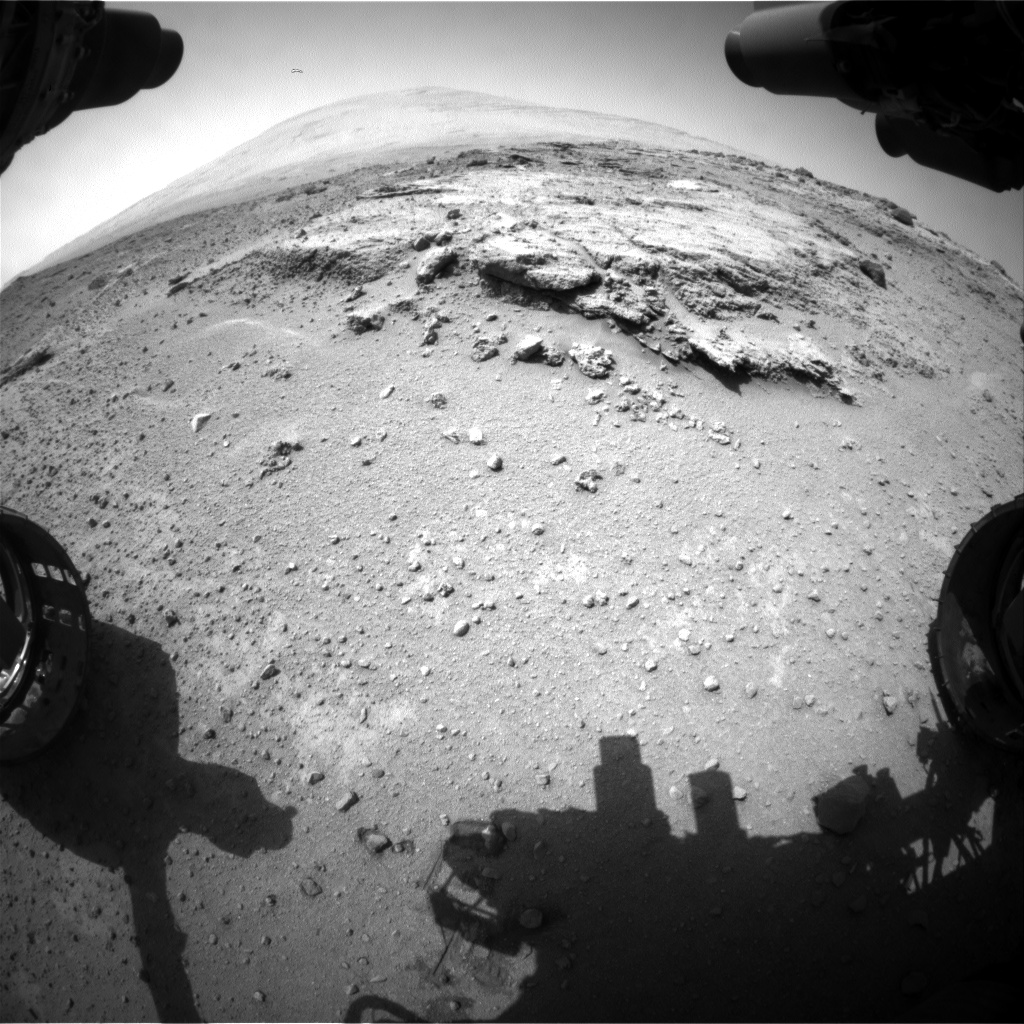
NASA's Mars rover Curiosity used a new technique, with added autonomy for the rover, in placement of the tool-bearing turret on its robotic arm during the 399th Martian day, or sol, of the mission. This image from the rover's front Hazard Avoidance Camera (Hazcam) on that sol shows the position of the turret during that process, with the Alpha Particle X-ray Spectrometer (APXS) instrument placed close to the target rock. Credit: NASA/JPL-Caltech
NASA’s Curiosity rover has discovered a new patch of pebbles formed and rounded eons ago by flowing liquid water on the Red Planet’s surface along the route she is trekking across to reach the base of Mount Sharp – the primary destination of her landmark mission.
Curiosity made the new finding at a sandstone outcrop called ‘Darwin’ during a brief science stopover spot called ‘Waypoint 1’.
Before arriving at Waypoint 1, the question was- “Did life giving water once flow here on the Red Planet?
The answer now is clearly ‘Yes!’ – And it demonstrates the teams wisdom in pausing to inspect ‘Darwin’.
The discovery at Darwin is significant because it significantly broadens the area here that was altered by flowing liquid water.
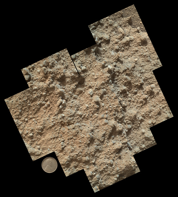
This mosaic of nine images, taken by the Mars Hand Lens Imager (MAHLI) camera on NASA’s Mars rover Curiosity, shows detailed texture in a conglomerate rock bearing small pebbles and sand-size particles. Credit: NASA/JPL-Caltech/MSSS
The presence of water is an essential prerequisite for the formation and evolution of life.
“Curiosity has arrived at Waypoint 1,” project scientist John Grotzinger, of the California Institute of Technology in Pasadena, told Universe Today at the time.
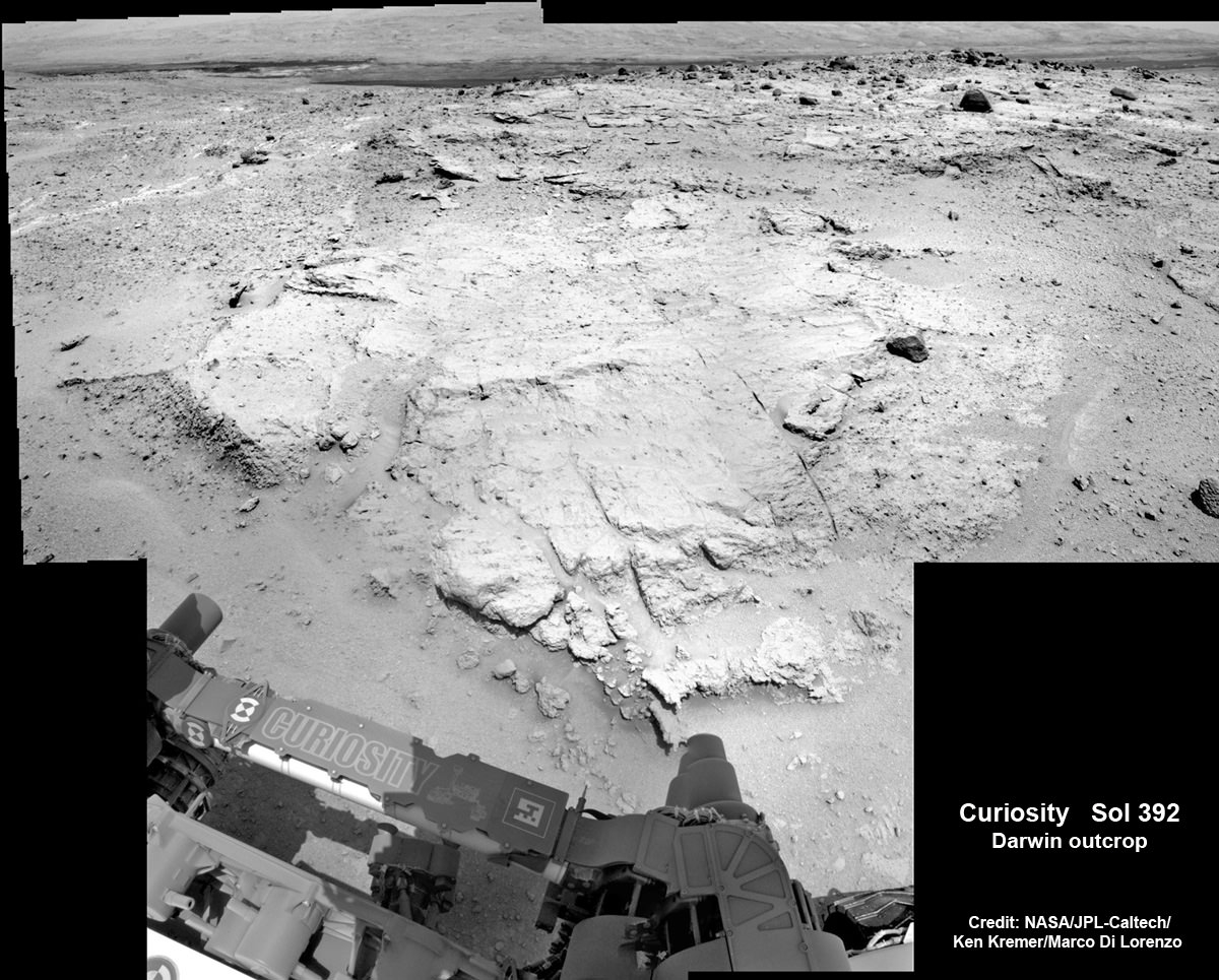
The robot pulled into ‘Waypoint 1’ on Sept. 12 (Sol 392).
“It’s a chance to study outcrops along the way,” Grotzinger told me.
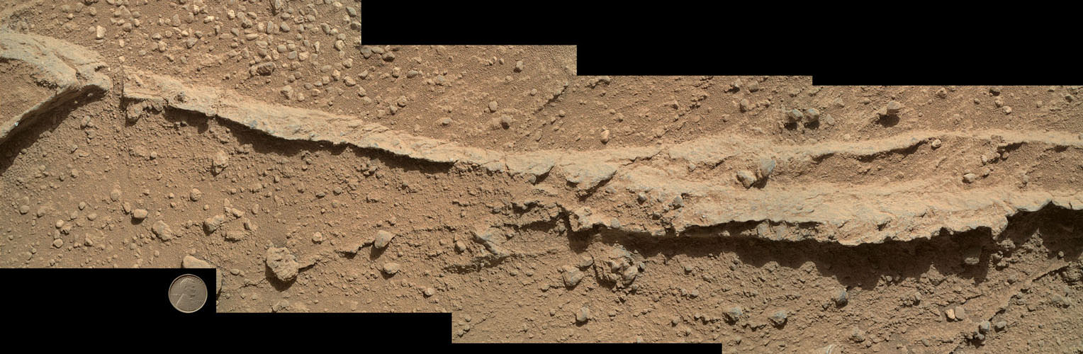
This mosaic of four images taken by the Mars Hand Lens Imager (MAHLI) camera on NASA’s Mars rover Curiosity shows detailed texture in a ridge that stands higher than surrounding rock. The rock is at a location called “Darwin,” inside Gale Crater. Exposed outcrop at this location, visible in images from the High Resolution Imaging Science Experment (HiRISE) camera on NASA’s Mars Reconnaissance Orbiter, prompted Curiosity’s science team to select it as the mission’s first waypoint for several days during the mission’s long trek from the “Glenelg” area to Mount Sharp. Image Credit: NASA/JPL-Caltech/MSSS
The six wheeled rover is in the initial stages of what is sure to be an epic trek across the floor of her landing site inside the nearly 100 mile wide Gale Crater – that is dominated by humongous Mount Sharp that reaches over 3 miles (5 Kilometers) into the red Martian Sky.
“We examined pebbly sandstone deposited by water flowing over the surface, and veins or fractures in the rock,” said Dawn Sumner of University of California, Davis, a Curiosity science team member with a leadership role in planning the stop, in a NASA statement about Darwin and Waypoint 1.
“We know the veins are younger than the sandstone because they cut through it, but they appear to be filled with grains like the sandstone.”
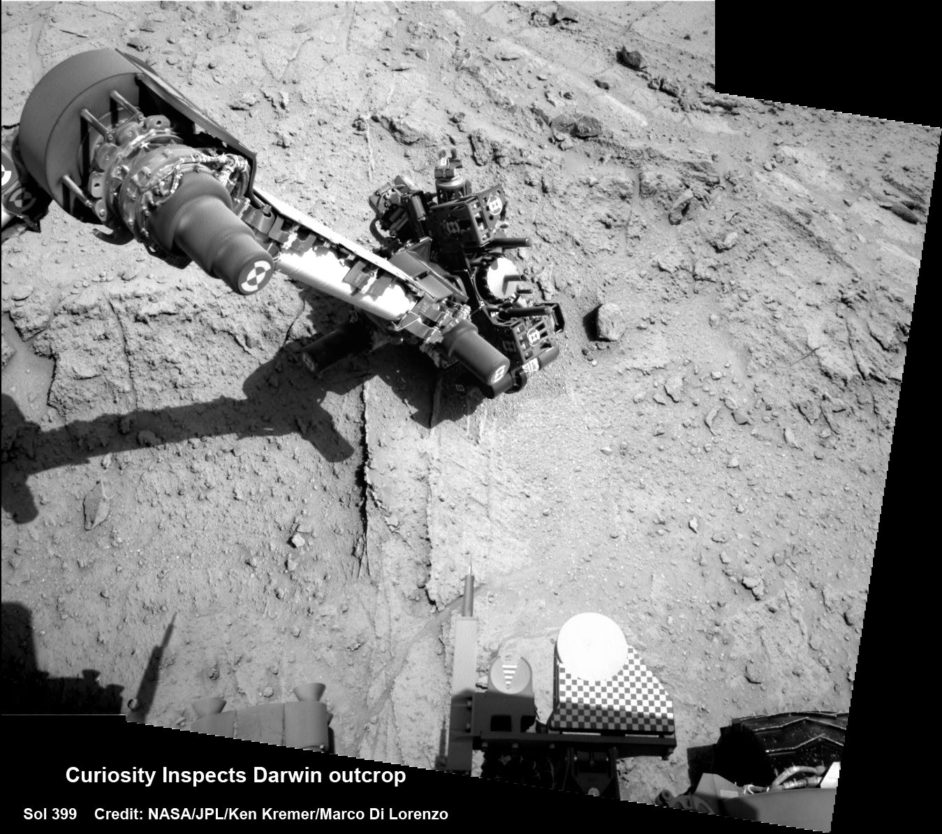
Curiosity deploys robot arm to investigate the ‘Darwin’ rock outcrop up close at ‘Waypoint 1’ on Sept 20 (Sol 399). This photo mosaic was assembled from navcam images taken on Sept 20, 2013. Credit: NASA/JPL-Caltech/Ken Kremer/Marco Di Lorenzo
Waypoint 1 is the first of up to five waypoint stops planned along the roving route that stretches about 5.3 miles (8.6 kilometers) between the “Glenelg” area, where Curiosity worked for more than six months through the first half of 2013, and the currently planned entry point at the base of Mount Sharp.
To date, the robot has now driven nearly 20% of the way towards the base of the giant layered Martian mountain she will eventually scale in search of life’s ingredients.
“Darwin is named after a geologic formation of rocks from Antarctica,” Grotzinger informed Universe Today.
‘Waypoint 1’ was an area of intriguing outcrops that was chosen based on high resolution orbital imagery taken by NASA’s Mars Reconnaissance Orbiter (MRO) circling some 200 miles overhead.
Investigation of the conglomerate rock outcrop dubbed ‘Darwin’ was the top priority of the Waypoint 1 stop.
The finding of a cache of watery mineral veins was a big added science bonus that actually indicates a more complicated story in Mars past – to the delight of the science team.
“We want to understand the history of water in Gale Crater,” Sumner said.
“Did the water flow that deposited the pebbly sandstone at Waypoint 1 occur at about the same time as the water flow at Yellowknife Bay? If the same fluid flow produced the veins here and the veins at Yellowknife Bay, you would expect the veins to have the same composition.’
“We see that the veins are different, so we know the history is complicated. We use these observations to piece together the long-term history.”
The Rover inspected Darwin from two different positions over 4 days, or Martian Sols and conducted ‘contact science’ by deploying the robotic arm and engaging the science instrument camera and spectrometer mounted on the turret at the arms terminus.
The Alpha Particle X-ray Spectrometer (APXS) collected spectral measurements of the elemental chemistry and the Mars Hand Lens Imager is a camera showing the outcrops textures, shapes and colors.
Curiosity investigates the ‘Darwin’ rock outcrop up close after arriving for a short stay at ‘Waypoint 1’ on Sept 12 (Sol 392). This photo mosaic was assembled from navcam images taken on Sept 12, 2013. Credit: NASA/JPL-Caltech/Ken Kremer/Marco Di Lorenzo
What’s the origin of Darwin’s name?
“Darwin comes from a list of 100 names the team put together to designate rocks in the Mawson Quadrangle – Mawson is the name of a geologist who studied Antarctic geology,” Grotzinger told me.
“We’ll stay just a couple of sols at Waypoint 1 and then we hit the road again,” Grotzinger told me.
And indeed on Sept. 22, the rover departed Darwin and Waypoint 1 on a westward heading to resume the many months long journey to Mount Sharp.
Learn more about Curiosity, Mars rovers, MAVEN, Orion, Cygnus, Antares, LADEE and more at Ken’s upcoming presentations
Oct 3: “Curiosity, MAVEN and the Search for Life on Mars – (3-D)”, STAR Astronomy Club, Brookdale Community College & Monmouth Museum, Lincroft, NJ, 8 PM
Oct 8: NASA’s Historic LADEE Lunar & Antares/Cygnus ISS Rocket Launches from Virginia”; Princeton University, Amateur Astronomers Assoc of Princeton (AAAP), Princeton, NJ, 8 PM
HiRISE image of lobate landforms called "brain terrain" that wrap around a small hill on Mars
It doesn’t take much thought to understand why this landscape on Mars is called “brain terrain” — the swirling lobes of ice, part of a large glacial deposit in Mars’ northern hemisphere, uncannily resemble the texture of a brain — or at the very least a brain coral!
What causes this strange landscape? Find out below:
It’s suggested that brain terrain is the result of the thermal stress and contraction, followed by sublimation, of these large ice deposits, laid down during a mid-latitude glaciation period ten to 100 million years ago. (Read more in this 2009 paper by Brown University’s Joseph Levy et al.)
This image was obtained by the HiRISE camera aboard the Mars Reconnaissance orbiter on August 23, 2013. See the original RGB color scan here.
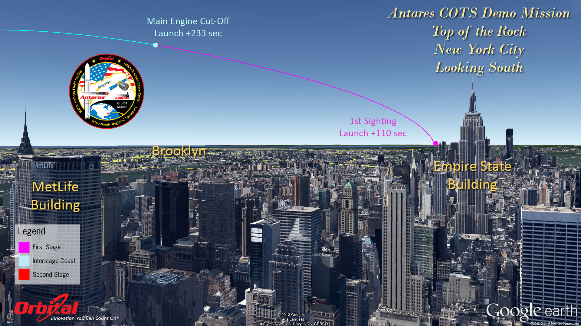
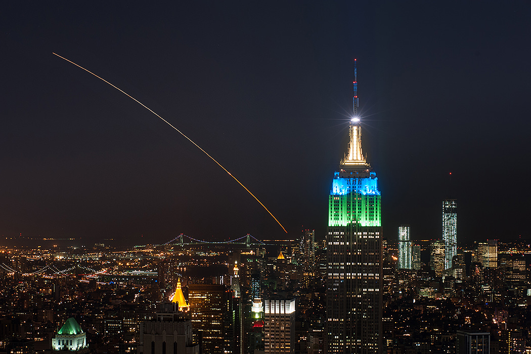
Top of the Rock - New York City. Antares rocket and Cygnus cargo spacecraft approximate launch trajectory view as should be seen from atop Rockefeller Center, NYC, on Sept. 18, 2013 at 10:50 a.m. EDT - weather permitting - after blastoff from NASA Wallops, VA. Credit: Orbital Sciences See more Antares launch trajectory viewing graphics below
Top of the Rock – New York City
Antares rocket and Cygnus cargo spacecraft approximate launch trajectory view as should be seen from atop Rockefeller Center, NYC, on Sept. 18, 2013 at 10:50 a.m. EDT – weather permitting – after blastoff from NASA Wallops, VA. Credit: Orbital Sciences See more Antares launch trajectory viewing graphics below[/caption]
WALLOPS ISLAND, VA – “All Systems Are GO” for the Sept. 18 launch of Orbital Sciences Antares commercial rocket carrying the first ever fully functional Cygnus commercial resupply vehicle to orbit on the history making first flight blasting off from NASA’s Wallops Island Facility– along the eastern shore of Virginia and bound for the International Space Station (ISS).
Here’s our guide on “How to See the Antares/Cygnus Launch” – complete with viewing maps and trajectory graphics from a variety of prime viewing locations courtesy of Orbital Sciences, the private company that developed both the Antares rocket and Cygnus spaceship aimed at keeping the ISS fully operational for science research.
And although the launch is slated for late morning it should still be visible to millions of spectators along a lengthy swath of the US East Coast from North Carolina to Connecticut – weather permitting – who may have never before witnessed such a mighty rocket launch.
The daylight liftoff of the powerful two stage Antares rocket is scheduled for Wednesday, Sept 18 at 10:50 a.m. EDT from Launch Pad 0A at the Mid-Atlantic Regional Spaceport at NASA Wallops Island, Virginia. The launch window extends 15 minutes to 11:05 a.m.
Up top is the view as anticipated from “The Top of the Rock” or Rockefeller Center in New York City. See below the extraordinary image of LADEE’s launch from “Top of the Rock” by Ben Cooper to compare the day and night time sighting delights.
In anticipation of liftoff, the Antares rocket was rolled out to Pad 0A on Friday morning Sept. 13 and I was on hand for the entire event – see my rollout photos here and upcoming.
Seaside panoramic view of Antares rocket and Cygnus spacecraft after rollout to Launch Pad 0A at NASA Wallops at the Virginia Eastern Shore on Sept. 13, 2013. Blastoff for the ISS is slated for Sept. 18, 2013 at 10:50 a.m. EDT. LADEE launch pad 0B stands adjacent to right of Antares.
Credit: Ken Kremer (kenkremer.com)
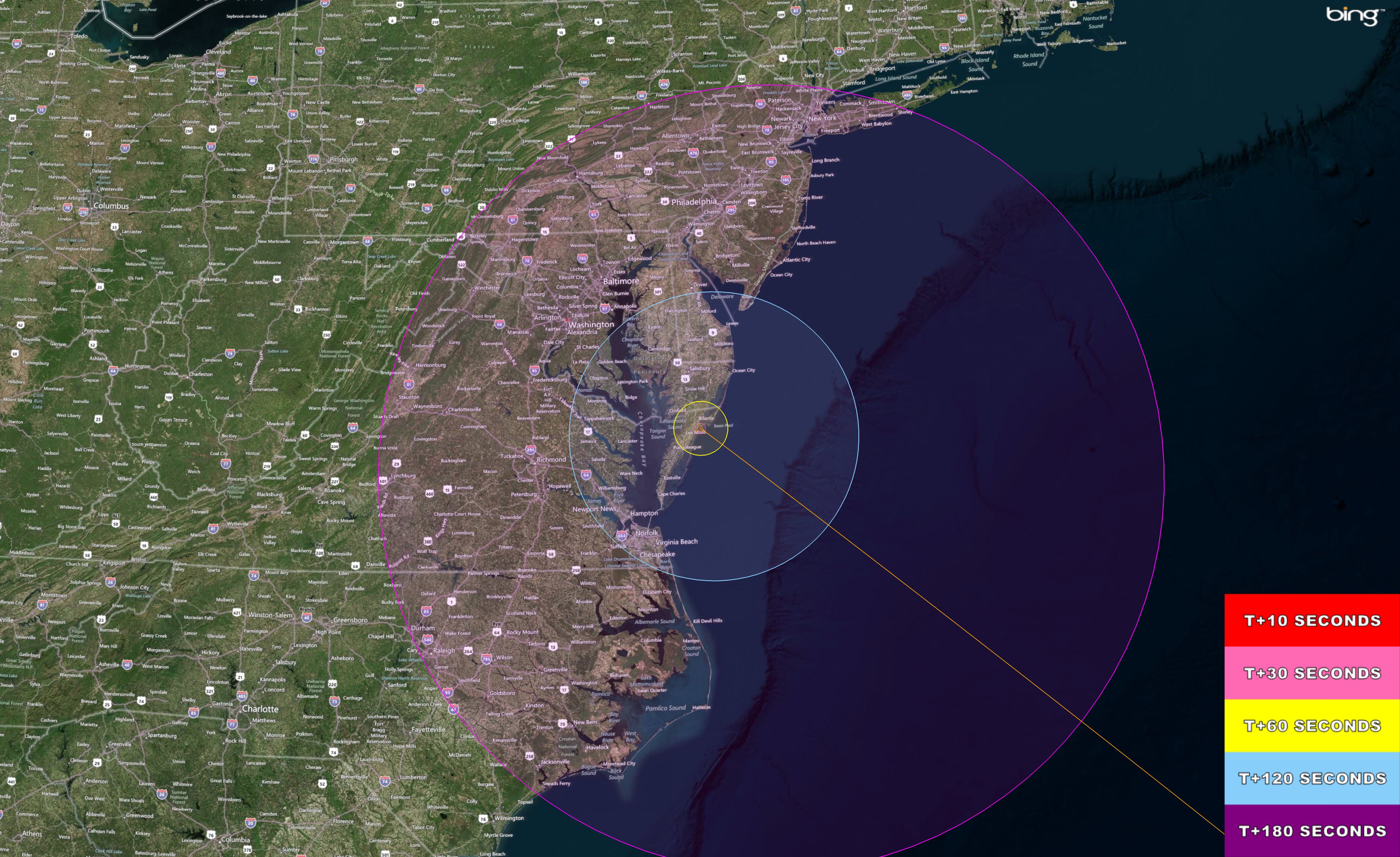
Here’s a hi res version of the viewing map courtesy of NASA Wallops Flight Facility:
Antares/Cygnus Launch – Hi Res Visibility map
The Antares/Cygnus daylight rocket launch on Sept. 18, 2013 at 10:50 a.m. EDT from NASA Wallops, VA. will potentially be visible to millions of spectators along the Eastern US coast from Connecticut to North Carolina -weather permitting. This high resolution map shows the regions of visibility over time in the seconds after the rocket launch on a demonstration cargo resupply mission to the International Space Station. Credit: NASA Wallops Flight Facility
The Antares launch follows closely on the heels of the spectacularly bright Sept. 6 nighttime Moon shot blastoff of the Minotaur V rocket that successfully injected NASA’s LADEE lunar orbiter into its translunar trajectory.
And just as was the case with the Minotaur V and LADEE, you don’t have to be watching locally to join in and experience all the fun and excitement. As with any NASA launch, you can also follow along with up to the minute play by play by watching the NASA TV webcast online or on smartphones, iPods or laptops.
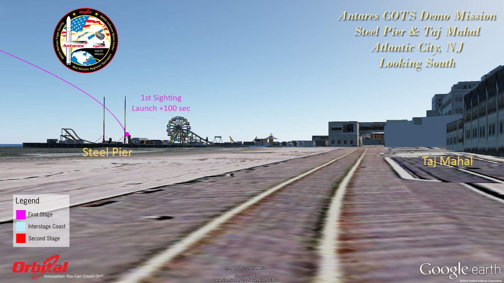
Atlantic City
It’s hard to say exactly how long and how bright the rockets flames and exhaust trail will be visible since it depends on the constantly changing lighting, prevailing clouds and overall weather conditions.
But one thing is for sure. If you don’t go outside and watch you’re giving up a great opportunity.
And keep in mind that Antares will be moving significantly slower than the Minotaur V.
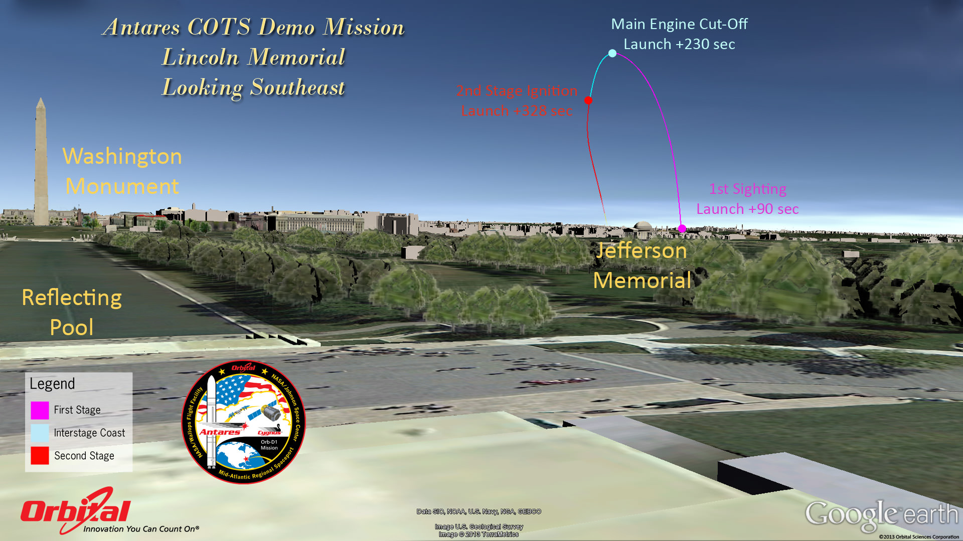
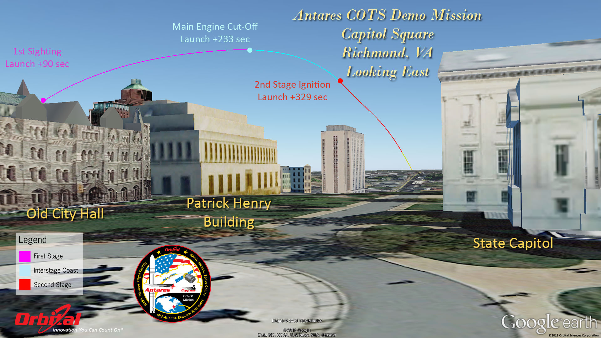
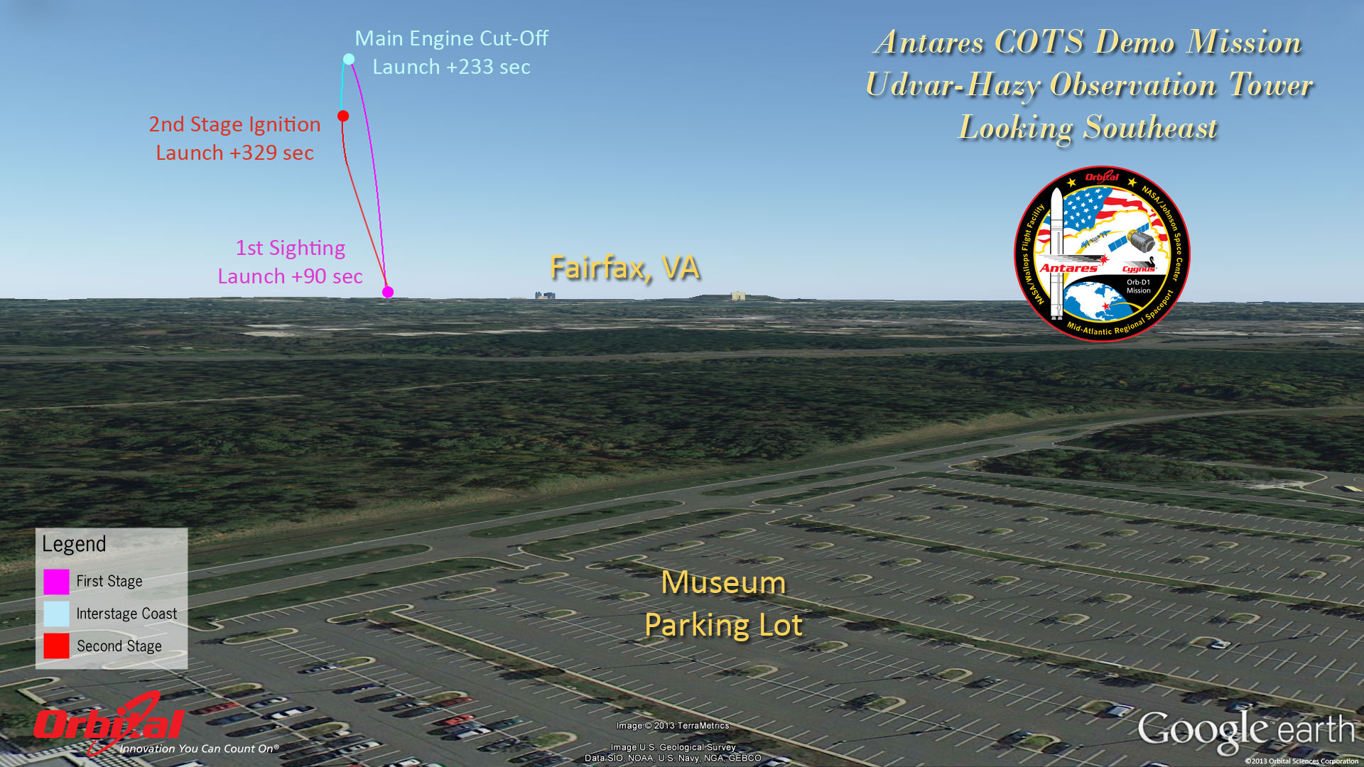
Herein are a series of graphics showing the Antares trajectory and what you should see during firings of both stages from the perspective of standing on the ground or skyscrapers at a variety of popular destinations including Annapolis, the US Capitol, Lincoln Memorial, National Air and Space Museum, Atlantic City, NJ, New York City and more.
Capitol East-Front StepsGoddard Space Flight Center – GSFCAntares rocket and Cygnus spacecraft after rollout to Launch Pad 0A at NASA Wallops Flight Facility Facility, VA.,on Sept. 13, 2013. Blastoff is slated for Sept. 18, 2013 at 10:50 a.m. EDT. LADEE launch pad 0B stands adjacent to right of Antares. Credit: Ken Kremer (kenkremer.com)
The goal of the mission is to demonstrate the safe and successful launch, rendezvous and docking of the privately developed Cygnus cargo carrier with the International Space Station (ISS) and delivery of 1300 pounds of essential supplies, food, clothing, spare parts and science gear to the six person resident human crews – currently Expedition 37.
Although it’s the 2nd launch of Antares following the maiden flight in April, this is the first flight of the Cygnus commercial delivery system. The demonstration and testing will be the same as what SpaceX accomplished in 2012 with their competing Falcon 9/Dragon architecture.
The mission is designated Orb-D1 and is funded with seed money by NASA’s COTS program to replace the cargo delivery duties of NASA’s now retired Space Shuttle orbiters.
Lincoln MemorialRichmond
For those who are traveling to witness the launch locally in the Chincoteague, Va., area, there will be two public viewing sites said Jeremy Eggers, NASA Wallops Public Affairs Officer in an interview with Universe Today.
“There will be are two local sites open to the public,” Eggers told me. “Folks can watch at either the NASA Wallops Flight facility Visitors Center (http://sites.wff.nasa.gov/wvc) or the beach at Assateague National Seashore (http://www.nps.gov/asis/index.htm).”
“There will be loudspeakers to follow the progress of the countdown, but no TV screens as done with the LADEE launch.”
National Air & Space Udvar-Hazy MuseumAnnapolis
So far the weather outlook is promising with a 75% chance of “GO” with favorable conditions at launch time.
NASA Television coverage of the Antares launch will begin at 10:15 a.m. on Sept 18 – (www.nasa.gov/ntv).
Be sure to watch for my continuing Antares and LADEE mission reports from on site at NASA’s Wallops Launch Pads in sunny Virginia – reporting for Universe Today.
Learn more about Cygnus, Antares, LADEE, Curiosity, Mars rovers, MAVEN, Orion and more at Ken’s upcoming presentations
Sep 17/18: LADEE Lunar & Antares/Cygnus ISS Rocket Launches from Virginia”; Rodeway Inn, Chincoteague, VA
Oct 3: “Curiosity, MAVEN and the Search for Life on Mars – (3-D)”, STAR Astronomy Club, Brookdale Community College & Monmouth Museum, Lincroft, NJ, 8 PM
Oct 8: LADEE Lunar & Antares/Cygnus ISS Rocket Launches from Virginia”; Princeton University, Amateur Astronomers Assoc of Princeton (AAAP), Princeton, NJ, 8 PM
This magnificent view of NASA’s LADEE lunar orbiter launched on Friday night Sept 6, on the maiden flight of the Minotaur V rocket from Virginia was captured by space photographer Ben Cooper perched atop Rockefeller Center in New York City. Compare this actual launch view to the graphic calculated for Antares (above) as seen from the exact same location atop Rockefeller Center. Credit: Ben Cooper/Launchphotography.com
Curiosity’s views a rock outcrop after arriving for a short stay at ‘Waypoint 1’- dramatically back dropped by her primary destination, Mount Sharp. Front hazcam camera image from Sol 393 (Sept 13, 2013). Credit: NASA/JPL-Caltech
Curiosity’s views a rock outcrop at ‘Darwin’ after arriving for a short stay at ‘Waypoint 1’ on Sept 12 (Sol 392) – dramatically back dropped by her primary destination, Mount Sharp. Front hazcam camera image from Sol 393 (Sept 13, 2013). Credit: NASA/JPL-Caltech
Story updated – see close up mosaic views of Darwin outcrop below[/caption]
NASA’s Curiosity Mars rover has just rolled into an intriguing site called ‘Darwin’ at ‘Waypoint 1’- having quickly picked up the driving pace since embarking at last on her epic trek to mysterious Mount Sharp more than two months ago. Did life giving water once flow here on the Red Planet?
Because the long journey to Mount Sharp – the robots primary destination – was certain to last nearly a year, the science team carefully choose a few stopping points for study along the way to help characterize the local terrain. And Curiosity has just pulled into the first of these so called ‘Waypoints’ on Sept 12 (Sol 392), the lead scientist confirmed to Universe Today.
“Curiosity has arrived at Waypoint 1,” project scientist John Grotzinger, of the California Institute of Technology in Pasadena, told Universe Today.
“Darwin is named after a geologic formation of rocks from Antarctica.”
She has now driven nearly 20% of the way towards the base of the giant layered Martian mountain she will eventually scale in search of life’s ingredients.
Altogether, the team selected five ‘Waypoints’ to investigate for a few days each as Curiosity travels in a southwestward direction on the road from the first major science destination in the ‘Glenelg’ area to the foothills of Mount Sharp, says Grotzinger.
“We’ll stay just a couple of sols at Waypoint 1 and then we hit the road again,” Grotzinger told me.
Curiosity’s Progress on Rapid Transit Route from ‘Glenelg’ (start at top) to Mount Sharp entry point (bottom). Triangles indicate geologic ‘Waypoint’ stopping points along the way. Curiosity arrived at Waypoint 1 on Sol 392 (Sept 12, 2013). Credit: NASA
‘Waypoint 1’ is an area of intriguing outcrops that was chosen based on high resolution orbital imagery taken by NASA’s Mars Reconnaissance Orbiter (MRO) circling some 200 miles overhead. See route map herein.
In fact the team is rather excited about ‘Waypoint 1’ that’s dominated by the tantalizing rocky outcrop discovered there nicknamed ‘Darwin’.
Although Curiosity will only stay a short time at each of the stops, the measurements collected at each ‘Waypoint’ will provide essential clues to the overall geologic and environmental history of the six wheeled rover’s touchdown zone.
“Waypoint 1 was chosen to help break up the drive,” Grotzinger explained to Universe Today.
“It’s a chance to study outcrops along the way.”
The images from MRO are invaluable in aiding the rover handlers planning activities, selecting Curiosity’s driving route and targeting of the most fruitful science forays during the long trek to Mount Sharp – besides being absolutely crucial for the selection of Gale Crater as the robots landing site in August 2012.
The ‘Darwin’ outcrop may provide more data on the flow of liquid water across the crater floor.
Evolving Excitement Over ‘Darwin’ Rock Outcrop at ‘Waypoint 1’. For at least a couple of days, the science team of NASA’s Mars rover Curiosity is focused on a full-bore science campaign at a tantalizing, rocky site informally called “Darwin.” This view of Darwin was taken with the Mast Camera (Mastcam) on Sol 390 (Sept. 10, 2013). Credit: NASA/JPL-Caltech/Malin Space Science Systems
The scientists goal is to compare the floor of Gale Crater to the sedimentary layers of 3 mile high (5 kilometer high) Mount Sharp.
Waypoint 1 is just over 1 mile along the approximately 5.3-mile (8.6-kilometer) route from ‘Glenelg’ to the entry point at the base of Mount Sharp.
Curiosity spent over six months investigating the ‘Yellowknife Bay’ area inside Glenelg before departing on July 4, 2013.
What’s the origin of Darwin’s name?
“Darwin comes from a list of 100 names the team put together to designate rocks in the Mawson Quadrangle – Mawson is the name of a geologist who studied Antarctic geology,” Grotzinger told me.
“Recently we left the Yellowknife Quadrangle, so instead of naming rocks after geological formations in Canada’s north, we now turn to formation names of rocks from Antarctica, and Darwin is one of them.
“That will be the theme until we cross into the next quad,” Grotzinger explained.
Curiosity investigates the ‘Darwin’ rock outcrop up close after arriving for a short stay at ‘Waypoint 1’ on Sept 12 (Sol 392). This photo mosaic was assembled from navcam images taken on Sept 12, 2013. Credit: NASA/JPL-Caltech/Ken Kremer/Marco Di Lorenzo
Inside Yellowknife Bay, Curiosity conducted the historic first interplanetary drilling into Red Planet rocks and subsequent sample analysis with her duo of state of the art chemistry labs – SAM and CheMin.
At Yellowknife Bay, the 1 ton robot discovered a habitable environment containing the chemical ingredients that could sustain Martian microbes- thereby already accomplishing the primary goal of NASA’s flagship mission to Mars.
“We want to know how the rocks at Yellowknife Bay are related to what we’ll see at Mount Sharp,” Grotzinger elaborated in a NASA statement. “That’s what we intend to get from the waypoints between them. We’ll use them to stitch together a timeline — which layers are older, which are younger.”
On Sept. 5, Curiosity set a new one-day distance driving record for the longest drive yet by advancing 464 feet (141.5 meters) on her 13th month on the Red Planet.
As Curiosity neared Waypoint 1 she stopped at a rise called ‘Panorama Point’ on Sept. 7, spotted an outcrop of light toned streaks informally dubbed ‘Darwin and used her MastCam telephoto camera to collect high resolution imagery.
Curiosity will use her cameras, spectrometers and robotic arm for contact science and a “full bore science campaign” involving in-depth mineral and chemical composition analysis of Darwin and Waypoint 1 for the next few Sols, or Martian days, before resuming the trek to Mount Sharp that dominates the center of Gale Crater.
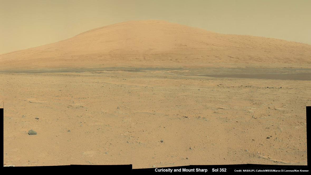
Curiosity Spies Mount Sharp – her primary destination. Curiosity will ascend mysterious Mount Sharp and investigate the sedimentary layers searching for clues to the history and habitability o the Red Planet of billions of years. This mosaic was assembled from Mastcam camera images taken on Sol 352 (Aug 2, 2013). Credit: NASA/JPL-Caltech/MSSS/ Marco Di Lorenzo/Ken Kremer
She will not conduct any drilling here or at the other waypoints, several team members have told me, unless there is some truly remarkable ‘Mars-shattering’ discovery.
Why is Curiosity now able to drive longer than ever before?
“We have put some new software – called autonav, or autonomous navigation – on the vehicle right after the conjunction period back in March 2013,” Jim Erickson, Curiosity Project Manager of NASA’s Jet Propulsion Laboratory (JPL), told Universe Today.
“This will increase our ability to drive. But how much it helps really depends on the terrain.”
And so far the terrain has cooperated.
“We are on a general heading of southwest to Mount Sharp,” said Erickson. See the NASA JPL route map.
“We have been going through various options of different planned routes.”
As of today (Sol 394), Curiosity remains healthy, has traveled 2.9 kilometers and snapped over 82,000 images.
If all goes well Curiosity could reach the entry point to Mount Sharp sometime during Spring 2014, at her current driving pace.
Learn more about Curiosity, Mars rovers,LADEE, Cygnus, Antares, MAVEN, Orion and more at Ken’s upcoming presentations
Sep 17/18: LADEE Lunar & Antares/Cygnus ISS Rocket Launches from Virginia”; Rodeway Inn, Chincoteague, VA
Oct 3: “Curiosity, MAVEN and the Search for Life on Mars – (3-D)”, STAR Astronomy Club, Brookdale Community College & Monmouth Museum, Lincroft, NJ, 8 PM
Oct 8: LADEE Lunar & Antares/Cygnus ISS Rocket Launches from Virginia”; Princeton University, Amateur Astronomers Assoc of Princeton (AAAP), Princeton, NJ, 8 PM
We missed a week, but now we’re back with the Weekly Space Hangout… back with a vengeance, with a full crew of 8 space journalists. We talked about the upcoming LADEE Launch, the test flight of SpaceShipTwo, an interview with Chris Kraft and much much more.
We broadcast the Weekly Space Hangout as a live Google+ Hangout on Air every Friday at 12:00pm Pacific / 3:00pm Eastern. You can watch the show on Universe Today, or from the Cosmoquest Event when we post it.
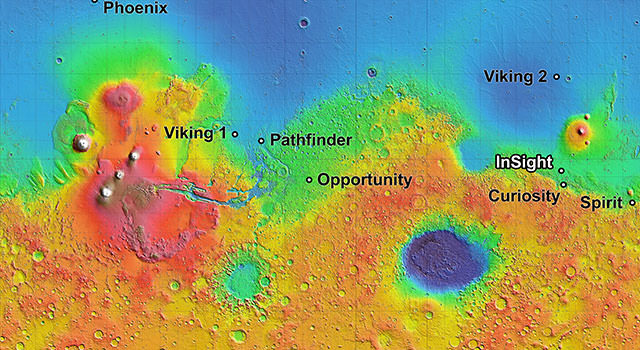
The process of selecting a site for NASA's next landing on Mars, planned for September 2016, has narrowed to four semifinalist sites located close together in the Elysium Planitia region of Mars. The mission known by the acronym InSight will study the Red Planet's interior, rather than surface features, to advance understanding of the processes that formed and shaped the rocky planets of the inner solar system, including Earth. Image credit: NASA/JPL-Caltech
Where’s the best place to drill baby, drill on Mars – and not for oil but digging into Mars’ past? Apparently, a relatively level spot near the equator is the preferred spot. The 2016 InSight lander is the next mission to land on Mars and it will use a probe to hammer down 3-5 meters under the surface. NASA has now narrowed down the potential landing sites to just four from an original twenty-two proposed locations, and all four lie along the planet’s mid-section on the plains of Elysium Planitia.
“We picked four sites that look safest,” said geologist Matt Golombek from the Jet Propulsion Laboratory. Golombek is leading the site-selection process for InSight. “They have mostly smooth terrain, few rocks and very little slope.”
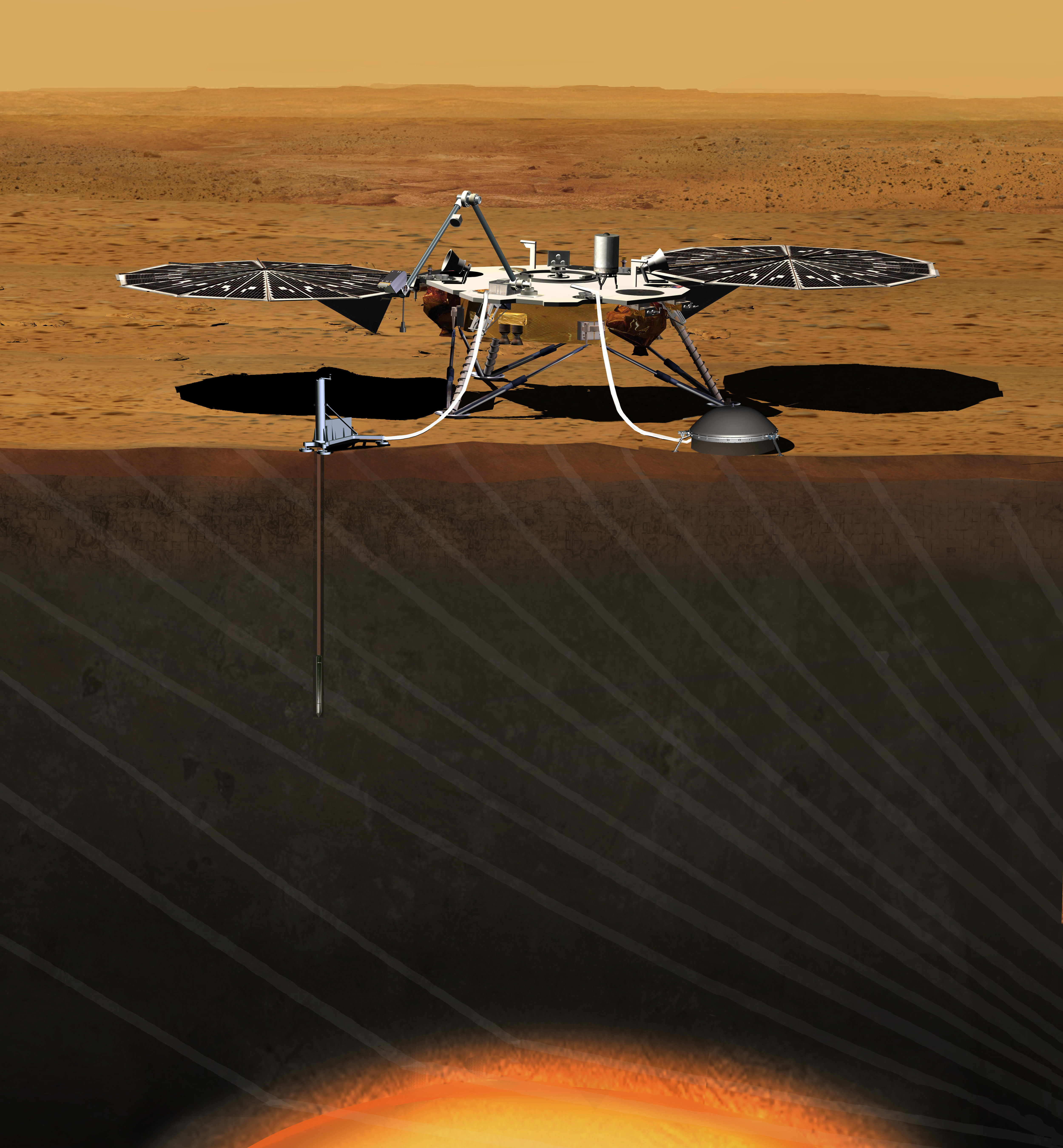
This artist’s concept depicts the stationary NASA Mars lander known by the acronym InSight at work studying the interior of Mars. Image credit: JPL/NASA
InSight stands for “Interior Exploration Using Seismic Investigations, Geodesy and Heat Transport” and it is scheduled to launch in March 2016 and land in September of that year. The mission will investigate processes that formed and shaped Mars and will help scientists better understand the evolution of our inner solar system’s rocky planets, including Earth. It will also monitor the planet’s current internal temperature and any seismology taking place.
So, unlike previous Mars landings, what is on the surface in the area matters little in the choice of a site except for safety considerations.
“This mission’s science goals are not related to any specific location on Mars because we’re studying the planet as a whole, down to its core,” said Bruce Banerdt, InSight principal investigator. “Mission safety and survival are what drive our criteria for a landing site.”
Elysium works well for the InSight mission because of two basic engineering constraints. One requirement is being close enough to the equator for the lander’s solar array to have adequate power at all times of the year. Also, the elevation must be low enough to have sufficient atmosphere above the site for a safe landing. The spacecraft will use the atmosphere for deceleration during descent.
InSight also needs penetrable ground for its probe that will monitor heat coming from the planet’s interior. This tool can penetrate through broken-up surface material or soil, but could be foiled by solid bedrock or large rocks. InSight also will deploy a seismometer on the surface and will use its radio for scientific measurements.
Images from the Mars Reconnaissance orbiter have been crucial in narrowing down the sites, and will continue to aid scientists and engineers in choosing the final site.
Golombek said that since considering what is below the surface is important to evaluate candidate landing sites, scientists also studied MRO images of large rocks near Martian craters formed by asteroid impacts. Impacts excavate rocks from the subsurface, so by looking in the area surrounding craters, the scientists could tell if the subsurface would have probe-blocking rocks lurking beneath the soil surface.
Each semifinalist site is an ellipse measuring 81 miles (130 kilometers) from east to west and 17 miles (27 kilometers) from north to south. Engineers calculate the spacecraft will have a 99-percent chance of landing within that ellipse, if targeted for the center.
The team will select two or three finalists by the end of 2014, and make a final decision on InSight’s destination by the end of 2015.
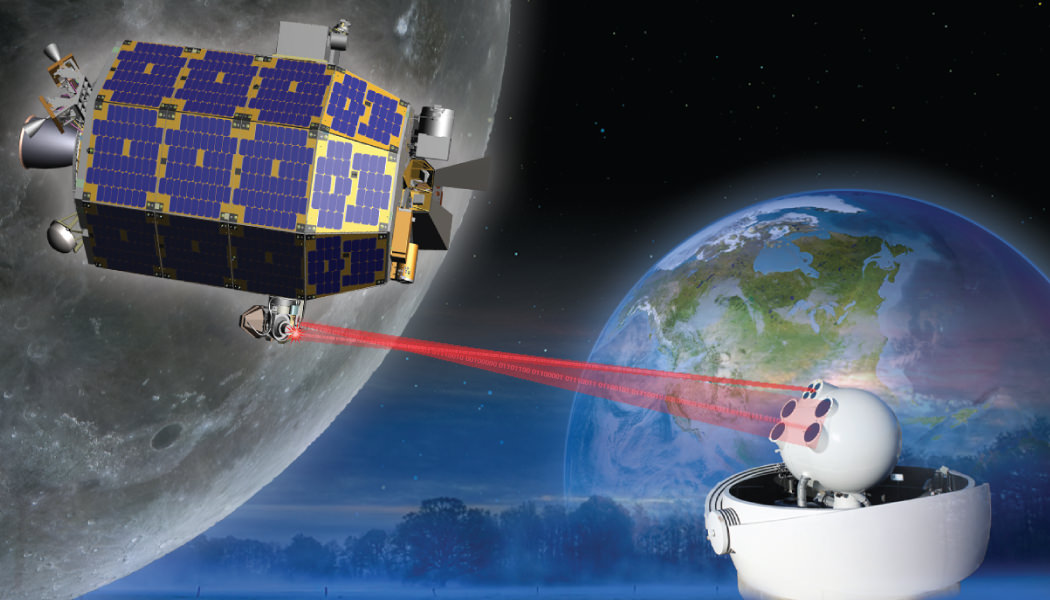
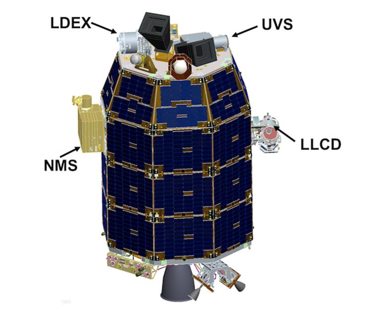
The LADEE satellite in lunar orbit. The revolutionary modular science probe is equipped with a Lunar Laser Communication Demonstration (LLCD) that will attempt to show two-way laser communication beyond Earth is possible, expanding the possibility of transmitting huge amounts of data. This new ability could one day allow for 3-D High Definition video transmissions in deep space to become routine. Credit: NASA
In an exclusive new interview with Universe Today, NASA’s Ames Research Center Director Pete Worden was “very excited” to discuss the historic Moon Shot set to launch NASA’s LADEE lunar orbiter from the Virginia coast and the NASA Wallops Island facility on Friday night, Sept. 6, that boasts “a new modular design” that can revolutionize how we explore our solar system “with robotic orbiters, landers and rovers” – and is aimed at “answering fundamental science questions.”
“LADEE is the first in a new class of interplanetary exploration missions,” NASA Ames Director Worden told Universe Today. NASA Ames leads the LADEE mission. “It will study the pristine moon to study significant questions.”
“And it will demonstrate a new modular approach that will give us science at a lower cost. We are very excited.”
“It will tell us a lot about the moon,” Worden told me.
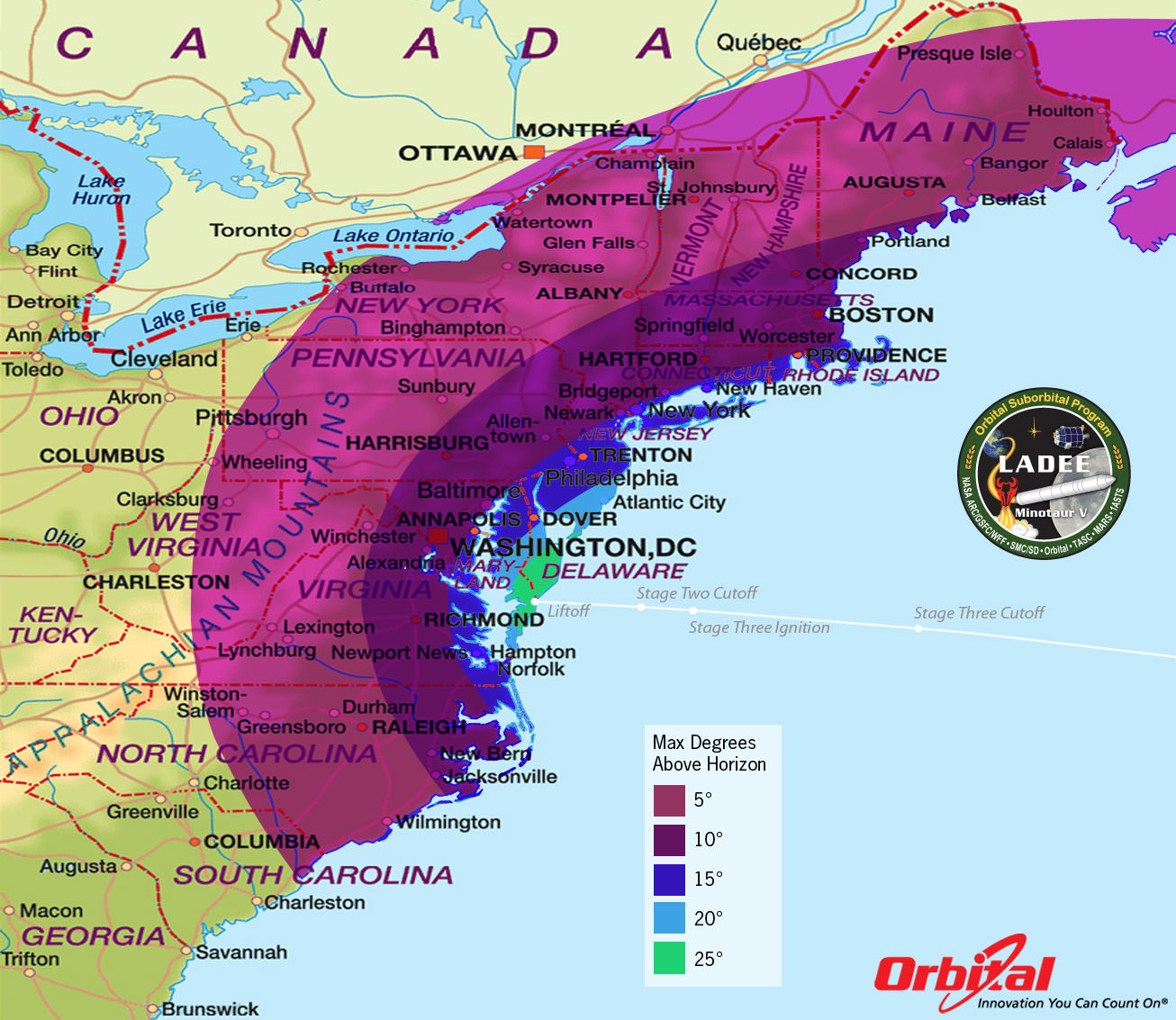
When America returns to the Moon with the LADEE spacecraft blasting off shortly before midnight Sept. 6, it could potentially be watched by many tens of millions of spectators – weather permitting – along the US East Coast stretching from Maine to the Carolina’s and into parts of the Midwest. See launch visibility map below.
LADEE Minotaur V Launch – Maximum Elevation Map
The LADEE nighttime launch will be visible to millions of spectators across a wide area of the Eastern US -weather permitting. This map shows the maximum elevation (degrees above the horizon) that the Minotaur V rocket will reach during the Sep. 6, 2013 launch depending on your location along the US east coast. Credit: Orbital Sciences
And the science timing for LADEE’s lunar mission is just perfect as well since several countries and corporations are gearing up to dispatch a batch of new orbiters and landers to Earth’s nearest neighbor that could change its character forever.
“This is probably our last best chance to study the pristine Moon before there is a lot of human activity there changing things.”
The purpose of LADEE’s trio of science instruments is to collect data that will inform scientists in unprecedented detail about the ultra thin lunar atmosphere, environmental influences on lunar dust and conditions near the surface.
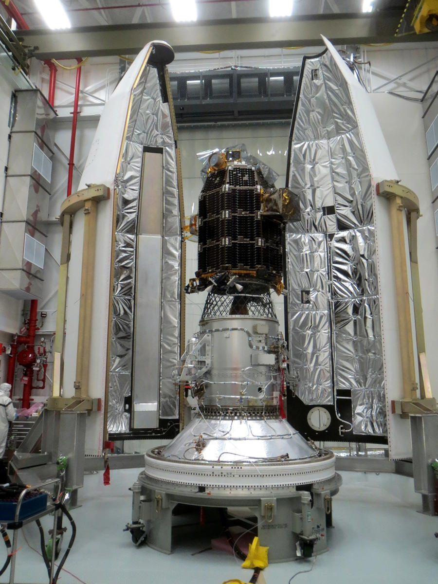
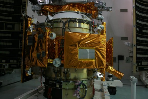
Engineers from NASA’s Ames Research Center have successfully completed launch preparation activities for blastoff of NASA’s Lunar Atmosphere and Dust Environment Explorer (LADEE) observatory on Sept. 6. The revolutionary modular science probe has been encapsulated into the nose-cone of the maiden Minotaur V rocket at NASA’s Wallops Flight Facility. Credit: NASA Ames
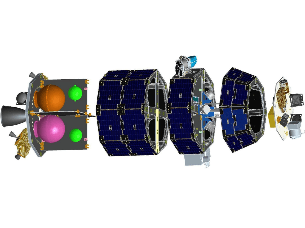
The couch sized probe is built on a ‘modular common spacecraft bus’, or body, that could be implemented on space probes to explore a wide variety of targets in the solar system.
“We think the modular bus is a winner,” Worden explained to Universe Today.
“LADEE could lead to other low cost missions to orbit and even land on the Moon, near Earth asteroids, Mercury and also the moons of Mars.”
“The LADEE bus is a strong contender for future NASA planetary missions, especially landers on bodies with a tenuous atmosphere. And small micro-rovers are possible too. We are really proud of it!”
A computer-generated model of the LADEE spacecraft based on the modular common spacecraft bus. Credit: NASA/Ames
LADEE is NASA’s first ever planetary mission to launch from the Eastern Shore of Virginia at NASA’s Wallops Flight Facility on Wallops Island. The blastoff is expected to draw large crowds. Some local hotels are already sold out.
The Lunar Atmosphere and Dust Environment Explorer (LADEE) Observatory is NASA’s next mission to the Moon.
It thunder’s to space at 11:27 p.m. Friday, Sept. 6, from launch complex 0B at NASA’s Wallops Island facility and the Mid-Atlantic Regional Spaceport (MARS) atop the maiden flight of the new, solid fueled Minotaur V rocket developed by Orbital Sciences Corp.
LADEE’s Ticket to the Moon – 5th Stage of new Minotaur V rocket
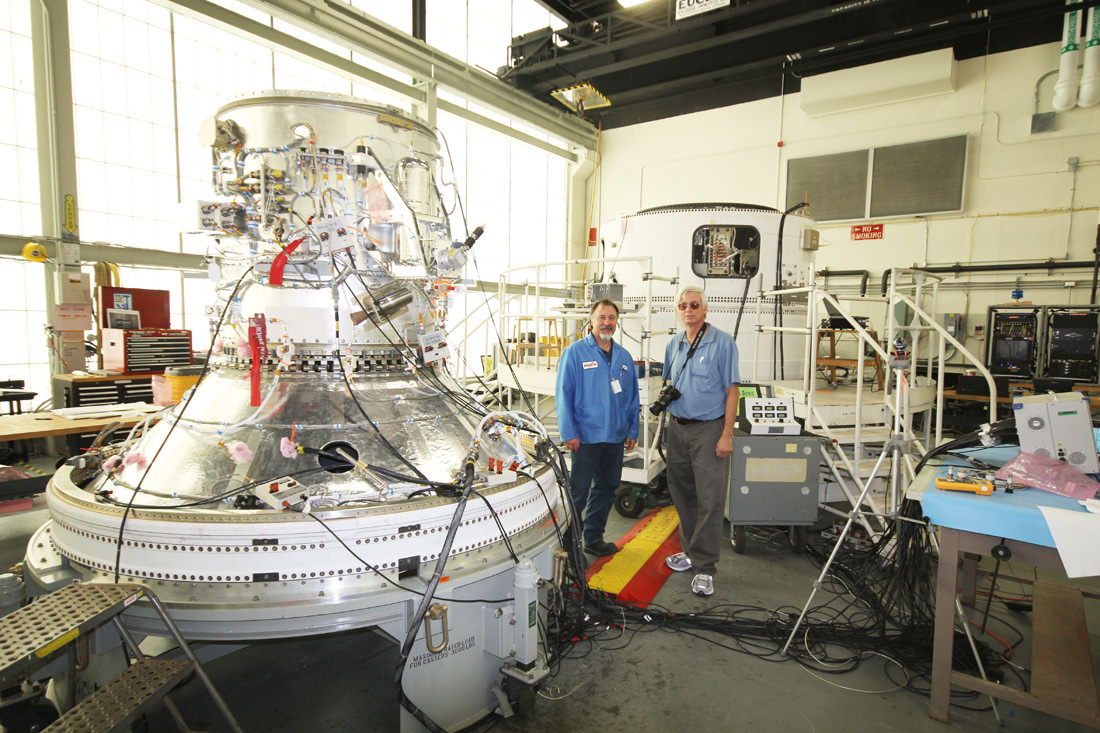
Close-up view of STAR 37 5th stage solid fuel motor for inaugural Minotaur V rocket launch at NASA Wallops rocket facility will propel LADEE into its lunar transfer orbit. LADEE will be mounted on top and surrounded by the payload fairing attached at bottom ring. Credit: Ken Kremer/kenkremer.com
The goal of the $280 Million mission is to gain a thorough understanding of long-standing unknowns about the tenuous atmosphere, dust and surface interactions that will help scientists understand other planetary bodies as well.
“After Apollo, the amazing thing is that we opened as many questions as we answered,” said Worden. “One of the key issues is – What is the environment on the Moon’s surface from the lunar day to the lunar night?”
“And what are the limitations that would place on our activities there?”
“Although the moon has a tenuous atmosphere it’s actually very active and interacts very strongly with the solar wind. It may produce something that on Earth we would call a ‘dust storm’.”
“We also wish to have the ‘ground truth’ [measurements] of the Moon’s environment before humans change things.”
And change is inexorably coming to the Moon rather soon.
“The Chinese plan to land on the Moon by year’s end,” Worden elaborated.
“What we found during Apollo is that an artificial disturbance very considerably changes the Moon’s atmosphere – or exosphere.”
“So we really want to known the pristine state of the lunar exosphere before its changed by human activity.”
“The data we have from Apollo surface measurements shows that it took many months for the lunar exosphere to go back to its pristine state.”
“Now there are probably a half dozen to a dozen programs planning to land on the Moon in the next decade. So we may never see the Moon’s pristine state again!”
“So these are pretty significant questions that we will have an opportunity to answer with LADEE.”
LADEE Science Instrument locations
LADEE is the first spacecraft of any kind that’s been designed, developed, built, integrated and tested at NASA’s Ames Research Center in Moffett Field, Calif.
“This is our first complete mission built out at Ames,” Worden explained.
“It’s also the first of a new paradigm where we are trying to develop a low cost modular bus design.
The approach on LADEE was to make it a mix and match modular bus – rather than a singular modular bus.
“So we have modular slices that use a propulsion stage, lander stage, communications stage, science payload stage, bus housekeeping stage and more,” Worden told me.
“In the past many others tried to build a ‘one size fits all’ modular bus. But it turns out that one size does NOT fit all needs.”
“So we took a page from how you build desktop computers.”
“We put in different modules that you can expand or subtract much more easily without changing the whole fundamental architecture or design.”
“So assuming this works well, I think you will see a lot more missions. And that makes it really exciting as our first mission.”
And the Ames modular bus has definitely sparked entrepreneurial interest.
“The bus is already an approach being used by at least one of the Google Lunar X-Prize competitors! The Moon Express team has looked at it a lot to transition that capability to them,” Worden explained.
How about future NASA missions?
“The LADEE bus is also a key part of several of our Ames proposals for future planetary missions,” Worden replied.
“The original design concept about seven years ago was for a small lunar lander. The lander propulsion would likely be a solid fueled stage.”
“Ultimately, NASA decided to go with the orbiter instead. And that showed the strength of the modular bus design – that it was very easy to change it from a lunar lander to the LADEE mission orbiter studying the lunar exosphere.”
I asked if it could deploy a small rover too?
“Yes- a small, micro rover is possible, perhaps 10 to 20 inches in size. And you could pack a lot of science on the small rover using today’s technology!
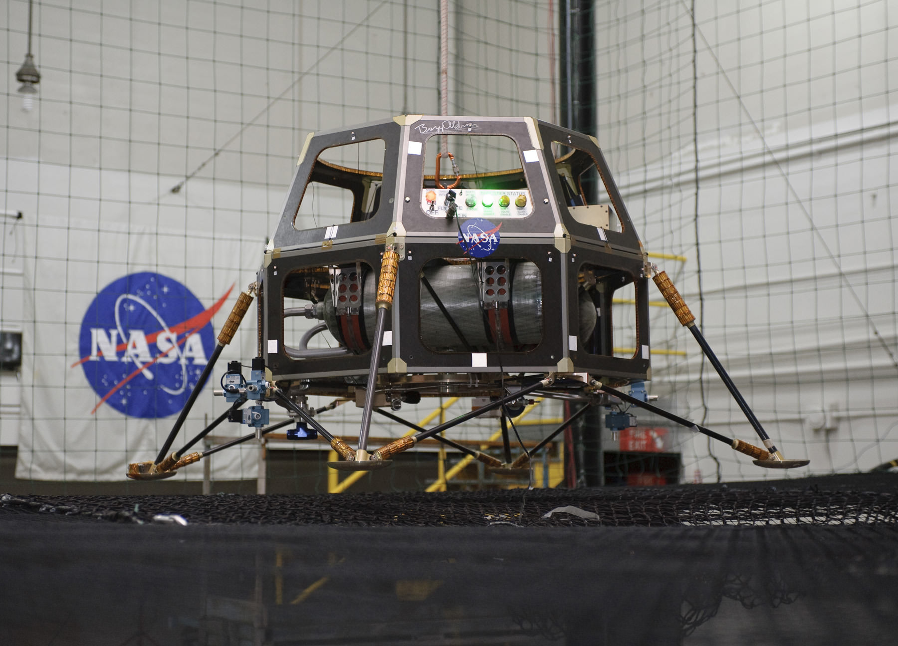
The Modular Common Spacecraft Bus lander configuration in a hover test in 2008. The lander could be used to deploy micro-rovers. Credit: NASA
Thus there are numerous exploration possibilities – all dependent on the Federal budget for NASA in this extremely difficult fiscal environment.
NASA Ames had “built parts and spacecraft components and science instruments before, but not a spacecraft in the entirety and in house,” Worden told Universe Today.
For example, a few years back Ames built the LCROSS lunar impacting spacecraft that smashed into the Moon’s south pole and discovered a treasure trove of water ice.
LCROSS piggybacked as a secondary science mission payload onto NASA’ s Lunar Reconnaisannce Orbiter (LRO) when the duo launched from Cape Canaveral, Florida atop an Atlas V rocket.
NASA Ames has now taken the next step – having designed and built the whole LADEE spacecraft from beginning to end.
“This is our first real baby. It’s very exciting,” beamed Worden.
“LADEE is a pretty phenomenal mission.”
They say “Virginia is for Lovers’
Well coming this Friday, “Virginia is for Space Lovers too!”
Chris Angulo, LADEE Program Engineering manager of Orbital Sciences, and Ken Kremer of Universe Today inspect the 4th and 5th stages of maiden Minotaur V rocket propelling NASA’s LADEE spacecraft to the Moon on Sept. 6 from NASA Wallops in Virginia. Credit: Ken Kremer/kenkremer.com
And remember that NASA has a 2nd historic launch from Wallops slated for Sep. 17 – with blastoff of the Orbital Sciences Antares rocket and Cygnus cargo carrier bound for its 1st flight to the International Space Station (ISS).
Be sure to watch for my continuing LADEE and Antares mission reports from on site at NASA’s Wallops Launch Pads in sunny Virginia – reporting for Universe Today.
…………….
Learn more about LADEE, Cygnus, Antares, MAVEN, Orion, Mars rovers and more at Ken’s upcoming presentations
Sep 5/6/16/17: “LADEE Lunar & Antares/Cygnus ISS Rocket Launches from Virginia”; Rodeway Inn, Chincoteague, VA, 8 PM
Oct 3: “Curiosity, MAVEN and the Search for Life on Mars – (3-D)”, STAR Astronomy Club, Brookdale Community College & Monmouth Museum, Lincroft, NJ, 8 PM
Oct 9: “LADEE Lunar & Antares/Cygnus ISS Rocket Launches from Virginia”; Princeton University, Amateur Astronomers Assoc of Princeton (AAAP), Princeton, NJ, 8 PM
Close Up Side view of NASA Ames built LCROSS lunar impactor. NASA Ames LADEE orbiter is equipped with the UVS science instrument based on LCROSS heritage. Credit: Ken Kremer/kenkremer.com
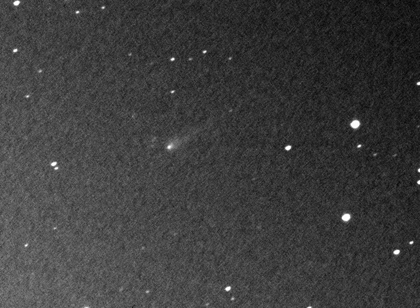
Comet ISON shows a small, compact coma and short, faint tail in this photo made by Krisztian Sarneczky on Aug. 31, 2013. Credit: K. Sárneczky / Konkoly Observatory
OK, you’ve waited patiently for Comet ISON to brighten and reappear in the dawn sky. It has. Now you’re chomping at the bit for a look at it in your telescope. Before you set the alarm and venture into the night, let’s prepare for what to expect. The better you know your target, the easier it will be to find.
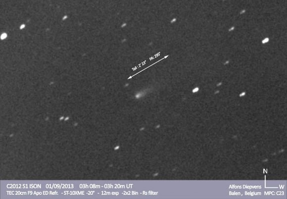
Astrophotographer Alfons Diepvens captured this view of ISON on Sept. 1, 2013 through his telescope. Tail length and direction are indicated. Click image to see more his photos of ISON and other recent comets. Credit: Alfons Diepvens
The latest brightness estimates from the amateur comet community place ISON around magnitude 13, bright enough to be within reach of 10-inch (25 cm) and larger telescopes. Alan Hale of Arizona, co-discover of Comet Hale-Bopp, was one of the first to see it. Through his 16-inch (41 cm) reflecting telescope on September 1, he noted the comet as a small object about 0.6 arc minutes across (1 arc minute = 1/30 the diameter of the full moon), brighter in the center and shining faintly at magnitude 13.1. Picture a small, dim patch of glowing mist and you’ve got the picture. Hale’s observing conditions were excellent though he did have to contend with light from the nearby crescent moon. Starting tomorrow morning, the moon will finally be out of the picture.
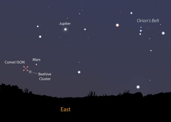
With the moon out of the sky, now is a great time to hunt for Comet ISON. This map shows the sky as you face east tomorrow morning Sept. 3 around 5 a.m. local time just before the start of morning twilight. The comet is near both Mars and the Beehive Cluster. Stellarium
A sharp-eyed observer under the best skies would expect to see a fuzzy object this faint in a telescope as small as 8-inches (20 cm). Most of us will need something a little bigger. A 10-12 incher (25-30 cm) should do the trick until the comet swells into the 11-12 magnitude range. But you’ll need more than a hefty scope. Key to spotting ISON are good charts, a steady atmosphere for sharp images (shaky air blurs faint objects into invisibility) and catching the comet at the right time. I also encourage you to use averted vision, a great technique for spotting faint sky objects. Instead of staring directly at the comet, look off to the side of its position. That way you allow the comet’s feeble photons to flood your eye’s rod cells, those most sensitive to dim light.
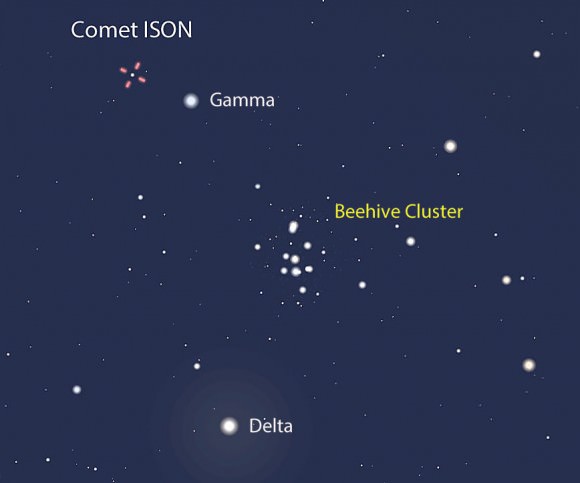
This tighter view shows the comet (on Sept. 3) in relation to the naked eye star Gamma Cancri and the pretty Beehive Cluster in Cancer the Crab. North is up, west to the right. Stellarium
While it now rises around 3-3:30 a.m. local time, you’ll get your best – or only – view once ISON has cleared the light-sucking thick air and haze so common near the horizon. The optimum viewing time occurs shortly before the start of morning twilight when the comet will be about 15 degrees high in the northeastern sky. At mid-northern latitudes,where twilight begins about 1.5 hours before sunrise, that’s around 5 a.m. Did I mention you’d lose a few hours sleep in your pursuit?
Comet ISON’s position plotted for 5 a.m. Central Daylight Time tomorrow through the 10th. Stars are shown to 12th magnitude. Click for larger version. Created with Chris Marriott’s SkyMap Pro program
Lucky for us comet hunters, ISON’s location is easy to find only a few degrees east of the 1st magnitude planet Mars and about 2 degrees north of the familiar Beehive Cluster or M44. The first map shows the general view to get you oriented. The second takes us in closer to show the comet’s relation to the Beehive Cluster, and the third provides a detailed telescopic view with stars plotted to about 12th magnitude. The comet positions on the detailed map are plotted for 5 a.m. CDT. Since ISON moves relatively slowly, those positions will be accurate for a time zone or two either way. If you live significantly farther east or west of the U.S. Central Time Zone, you can interpolate between the tick marks.
It’s good news for skywatchers from here on out as ISON continues to brighten and rise higher in the east with each passing night. A month from now, it should be visible in scopes as small as 6-inches (15 cm). Good luck in your comet quest!
Mars on September 8th. (Created by the author using Stellarium).
Launch season for Mars missions is almost upon us once again.
This is a time when spacecraft can achieve an optimal trajectory to reach the Red Planet, expending a minimal amount of fuel and taking the shortest period of time. This window of opportunity, which opens once every two years, always opens up about six months prior to Martian opposition.
For you stargazers, this is also the best time to observe the Red Planet as it makes its closest approach to Earth. And no, it won’t appear as large as a Full Moon, but it will make for a fine telescopic target.
During the last launch window in 2011-12, Mars Curiosity made the journey, and Russia’s Phobos-Grunt tried. Hey, it’s a tough business, this spaceflight thing. This time around, The Indian Space Research Organization (ISRO) hopes to launch its first ever interplanetary spacecraft, with its Mars Orbiter Mission departing on October 18th. NASA is also sending its Mars Atmosphere Volatile EvolutioN mission known as MAVEN to study the atmosphere of the Red Planet.
Opposition next occurs on April 8th, 2014, but the start of launch season always finds Mars emerging high to the east at dawn. Starting next week, Mars has some interesting encounters that are worth checking out as a prelude to the upcoming opposition season.
The planet Mars shines at +1.6 magnitude and is about 4” in size in September. This is a far cry from its maximum size of 15.1” that it will achieve next spring, and its grandest maximum size of 25.1” that it reached in 2003. All oppositions of Mars are not created equal, because of the planet’s 9.3% eccentric orbit.
But the good news is, we’re trending towards a better series of oppositions, which follow a roughly 15 year cycle. In 2018, we’ll see an opposition nearly as good as the 2003 one, with Mars appearing 24.1” in size. This is also the time frame that Dennis Tito wants to launch his crewed Mars 2018 flyby.
But back to the present. The action starts on September 2nd when the waning crescent Moon passes 6.1 degrees SSW of Mars.
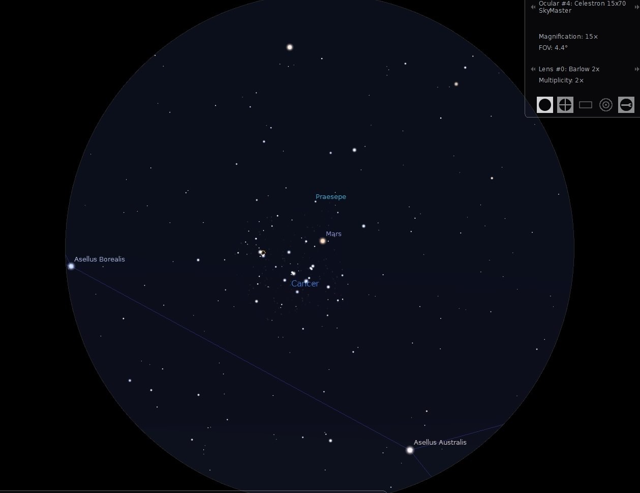
Mars is currently in the constellation Cancer, and will actually transit (pass in front of) the open star cluster known as the Beehive or Messier 44, standing only 0.23 degrees from its center on September 8th. M44 is 1.5 degrees in size, and this presents an outstanding photo-op.
The path of Mars through the beehive cluster from September 3rd through September 12th. (Created in Starry Night; Image courtesy of Starry Night Education).
At high power, you might just be able to catch the real time motion of Mars against the background stars of M44. Mars currently rises three hours before the Sun, giving you a slim window to accomplish this feat.
Mars is also in the midst of a series of transits of the Beehive Cluster, with one occurring every other year. Mars last crossed M44 on October 1st, 2011. The next time you’ll be able to spy this same alignment won’t be until August 20th, 2015.
But another cosmic interloper may photo-bomb Mars in September.
We’re talking about none other than Comet C/2012 S1 ISON, the big wildcard event of the season. Comet ISON is just peeking out from behind the Sun now, and dedicated amateurs have already managed to recover it. “IF” it follows projected light curve predictions, ISON may reach binocular visibility of greater than +10th magnitude by October 1st and may breech naked eye visibility by early November.
ISON approaches within two degrees of Mars on September 27th. Its closest apparent approach is will be on Oct 18th at a minimum separation of 0.89 degrees, just over the size of a Full Moon. How bright ISON will actually be at that point is the question of the season. To quote veteran comet hunter David Levy, “Comets are like cats. They have tails, and they do whatever they want.” The closest physical approach of Mars and Comet ISON is on October 1st at 0.07 astronomical units, or 10.4 million kilometres apart. Both will be crossing over from the astronomical constellations of Cancer into Leo in late September.
Comet ISON and Mars looking east on the morning of September 27th. (Created in Starry Night; Image courtesy of Starry Night Education).
Mars gets another close shave from a comet next year, when Comet C/2013 A1 Siding Spring passes 123,000 kilometres from Mars on October 19th, 2014. Interestingly, MAVEN will be arriving just a month prior to this if it departs Earth at the start of its 21 day window. Engineers have noted that an increase in cometary dust may be a concern for the newly arrived spacecraft during insertion into Martian orbit.
MAVEN Principal Investigator Bruce Jakosky notes that the first concern is the safety of the spacecraft, the second is studies of Mars, and the third is, just perhaps, to carry out observations of the comet.
Look for more information on Universe Today about the Martian cometary flybys as each event gets closer.
September is a great time to begin observations of the Red Planet. Usually, 8” seconds in diameter is the threshold that is frequently quoted for the first surface features (usually to polar ice caps) to become apparent, but we’re already seeing astro-imagers getting detailed images of Mars, right now.
Be sure to follow Mars on its trek across the September dawn skies as robotic explorers prepare to embark on their epic journeys!