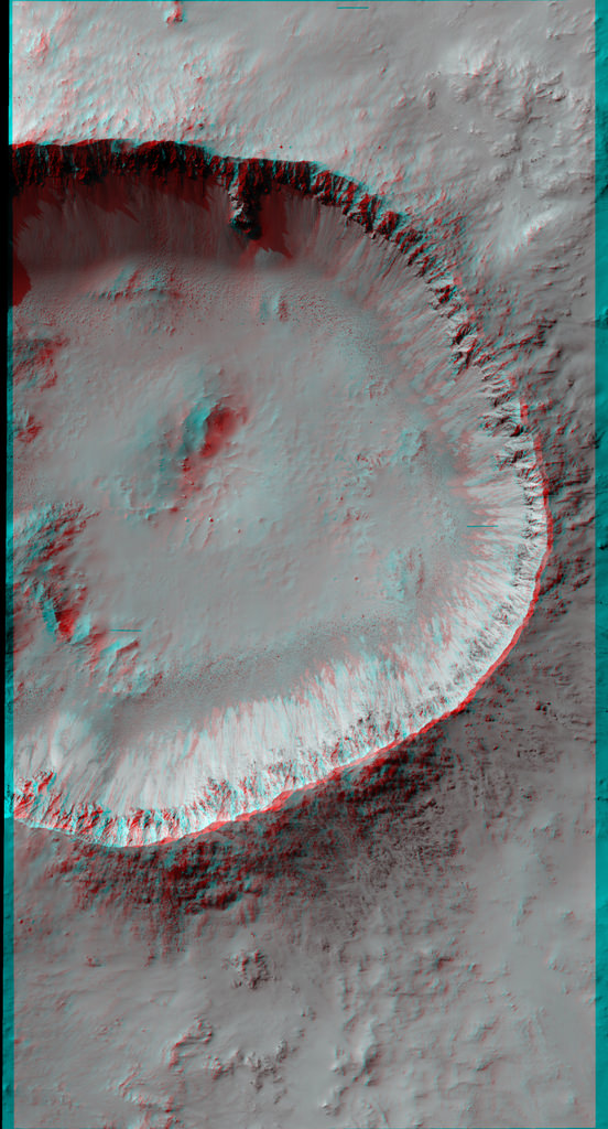
A 3-d view of a well-preserved and unnamed impact crater on Mars, as seen by the HiRISE camera on the Mars Reconnaisancee Orbiter. Credit: NASA/JPL/University of Arizona. Click for high-resolution version.
[/caption]
This is why I always keep a pair of 3-D glasses by my computer. This well-preserved crater on Mars may look like just your average, run-of-the-mill impact crater in 2-D, but in 3-D, the sharply raised rim, the deep, cavernous crater body, and especially the steep crater walls will have you grabbing your armchairs so you don’t fall in. The image is courtesy of the HiRISE camera team from the Mars Reconnaissance Orbiter. This unnamed crater is about 6 or 7 kilometers wide from rim to rim. HiRISE took the image on New Year’s Eve 2011.
HiRISE principal investigator Alfred McEwen says that the camera has imaged hundreds of well-preserved impact craters on Mars ranging from 1 meter to more than 100 kilometers wide. What can the scientists learn from craters?
“These targets are of great interest for multiple reasons,” he said. “First, we want to better understand impact cratering, a fundamental surface process. Second, such craters often contain good exposures of bedrock in the steep walls and, if the crater is large enough, in the central uplift. Just like terrestrial geologists are attracted to good bedrock outcrops like road cuts, planetary geologists are attracted to well-preserved craters.
“Third, the steep slopes often reveal active processes, such as formation of gullies, boulder falls, and slope streaks that could form in a variety of ways. Some of these active processes could be related to water, since the crater may expose lenses of ice or salty water, or create deep shadows that trap volatiles, or expose salts that can extract water from the air.”
Plus, they are just plain wonderful to behold, especially in the resolution the HiRISE can obtain.
A non-3-D version of the same image. Credit: NASA/JPL/University of Arizona
Poster art for the Russian Phobos-Grunt mission. Russian Federal Space Agency)/IKI
[/caption]
Russia says “eish odin ras”* for its Mars moon lander mission, according to Roscomos chief Vladimir Popovkin.
If the European Space Agency does not include Russia in its ExoMars program, a two-mission plan to explore Mars via orbiter and lander and then with twin rovers (slated to launch in 2016 and 2018, respectively), Roscosmos will try for a “take-two” on their failed Phobos-Grunt mission.
“We are holding consultations with the ESA about Russia’s participation in the ExoMars project… if no deal is reached, we will repeat the attempt,” said Popovkin on Tuesday.
Phobos-Grunt, an ambitious mission to land on the larger of Mars’ two moons, collect samples and return them to Earth, launched successfully on November 9, 2011. It became caught in low-Earth orbit shortly afterwards, its upper-stage engines having failed to ignite.
After many attempts to communicate with the stranded spacecraft, Phobos-Grunt re-entered the atmosphere and impacted on January 15. Best estimates place the impact site in the Pacific Ocean off the coast of southern Chile.
The failed mission also included a Chinese orbiter and a life experiment from The Planetary Society.
Russia is offering ESA the use of a Proton launch vehicle for inclusion into the ExoMars mission, now that the U.S. has canceled its joint participation and Atlas carrier. Roscomos and ESA are scheduled to discuss the potential partnership in February.
Topographic map from Mars Global Surveyor showing colour-coded altitudes; the blue areas are the lowest and correspond to the possible ancient ocean in the northern hemisphere. Credit: NASA/JPL
[/caption]
For a long time now, evidence has continued to indicate that Mars was once a water world – near-surface groundwater, lakes, rivers, hot springs and, according to some planetary models, even an ancient ocean in the northern hemisphere. That last one in particular has been a subject of intense debate; some scientists see evidence for it while others do not. Even if it was there, it may have been a warm ocean or it may have been colder, like the polar seas here on Earth. The prospect of an ocean of any kind on early Mars is an exciting one, regarding the question of possible life way back then. The argument has swung both ways over the years, but now another new report has been published which comes down on the “yes” side.
The results come from the Mars Express Orbiter – specifically its ground-penetrating radar (MARSIS) and they have just been published in Geophysical Research Letters by Jérémie Mouginot from the University of California. The findings reinforce the idea of a large ocean which occupied much of the northern hemisphere, also known as Oceanus Borealis.
The radar has mapped the sedimentary deposits within the region, known as the Vastitas Borealis Formation, which are about 100 metres (328 feet) thick and overlie deeper volcanic deposits. Significantly, the mapping of the dielectric constant showed that the sedimentary deposits left over from the putative ocean differ from volcanic rock – they have a value of about 4-5, while volcanic deposits have a value of 9, 10 or even higher. Pure ice has a value of 3.1.
According to the research team, “Although much is still unknown about the evolution and environmental context of a Late Hesperian ocean, our observations provide persuasive evidence of its existence by the measurement of a dielectric constant of the Vastitas Borealis Formation that is sufficiently low that it can only be explained by the widespread deposition of (now desiccated) aqueous sediments or sediments mixed with massive ice.”
The big question has always been, if there was an ocean, where did all the water go? Additional radar mapping from Mars Express has shown that there are massive amounts of water ice buried beneath the surface, notably at the poles as well as within the speculative shorelines of the old ocean and even closer to the equator than was previously thought. It might seem reasonable to conclude then that much of the water from the ocean, and perhaps other seas or lakes as well, is still there, but now frozen solid.
It’s interesting to note also that the Phoenix lander, which landed within the Vastitas Borealis Formation in 2008, found water ice deposits only a few centimetres below the surface.
“As such, the formation represents the best geologic evidence to date for the existence of an ocean in the Late Hesperian, about 3 billion years ago,” the researchers said.
From the abstract:
A number of observations suggest that an extended ocean once covered a significant part of the Martian northern hemisphere. By probing the physical properties of the subsurface to unprecedented depth, the MARSIS/Mars Express provides new geophysical evidences for the former existence of a Late Hesperian ocean. The Vastitas Borealis formation, located inside a putative shoreline of the ancient ocean, has a low dielectric constant compared with that of typical volcanic materials. We show that the measured value is only consistent with low-density sedimentary deposits, massive deposits of ground-ice, or a combination of the two. In contrast, radar observations indicate a distribution of shallow ground ice in equilibrium with the atmosphere in the south polar region. We conclude that the northern plains are filled with remnants of a late Hesperian ocean, fed by water and sediments from the outflow channels about 3 Gy ago.
The full article can be purchased here ($25.00 U.S.).
New estimates of water ice on Mars suggest there may be large reservoirs of underground ice at non-polar latitudes. The map here shows "water-equivalent hydrogen". Oranges and reds on the map (values greater than 4.5 weight % water-equivalent hydrogen at the surface) point out areas where the amount of deeply buried water ice is greater than what can fit in the pore spaces of the surface rocks. Image credit: Feldman et al., 2011
[/caption]
Many models predict that water ice shouldn’t be stable on Mars today, anywhere beyond the poles, no matter how deep you bury it. And yet, a recently published study shows that large regions outside the polar areas may, in fact, contain a relative abundance of water. This is exciting, not only because water has implications for the possibility of life on Mars, but also because it can provide a valuable resource to future explorers, both as a fuel and for life support. And if this water is near the equator, that makes it much easier to get to.
Over the past 7 years, lots of spacecraft observations have given us evidence for the presence of water on Mars, either at the surface or not far below. Radar data have shown that large amounts of water ice are stored at the poles (Lots of Pure Water Ice at Mars North Pole). And pictures of gullies have hinted at reserves of water beneath the surface (NASA Says Liquid Water Made Martian Gullies). Now, a team of scientists, led by Dr. William Feldman of the Planetary Science Institute in Tucson, Arizona, have taken a new look at some of that data.
Dr. Feldman and his team used data from the Mars Odyssey Neutron Spectrometer (MONS) to estimate the amount of water ice that is present outside of the polar regions of Mars, where water ice is not expected to be found. The MONS is an instrument that counts Martian neutrons from orbit. These “neutron counts” are sensitive to the presence of hydrogen and how deep it is below the surface. Using models that take the characteristics of the Martian surface and the relationship of hydrogen to water into account, the MONS data can be used to predict the amount and depth of water and water ice in the surface. Doing just that, Dr. Feldman’s team produced a nearly global map of potential underground ice deposits.
New estimates of water ice on Mars suggest there may be large reservoirs of underground ice at non-polar latitudes. The map here shows "water-equivalent hydrogen". Oranges and reds on the map (values greater than 4.5 weight % water-equivalent hydrogen at the surface) point out areas where the amount of deeply buried water ice is greater than what can fit in the pore spaces of the surface rocks. Image credit: Feldman et al., 2011.
This map shows the “weight percent of water-equivalent hydrogen”, or how much of the rock’s weight comes from hydrogen that is bound up in water molecules. Since hydrogen atoms are much lighter than the other atoms that make up a rock, a small weight percent of hydrogen equals a much larger volume of water ice. In fact, Dr. Feldman’s team estimate that values of 4.5 weight % hydrogen or greater (oranges and reds on the map), mean the volume of water ice at depth is larger than what can fit into pore spaces (the spaces between the grains that make up a rock). This means that you no longer have ice in a rock; now you have rocks in ice!
Four regions containing such bulk ice stand out in the map: Promethei Terra in the lower right of the map, Arabia Terra in the upper centre, Arcadia Planitia in the upper left, and Elysium Planetia spanning from the centre right, across the Martian “date line” (180 degrees longitude), to the centre left of the map. The ice deposits here are “buried less than about 1 m below the surface,” writes Dr. Feldman. He does admit that their findings may also indicate the presence of large quantities of minerals that contain water molecules in their chemical make-up. However, their results are supported by other evidence. In the Elysium Planetia region, evidence of glacial features has been seen in high resolution stereo data from ESA’s Mars Express orbiter ( Mars Express Reveals Possible Martian Glaciers). And in the Arcadia Planitia region, buried water ice has been identified in CRISM data, where an almost pure ice layer was excavated from less than 1 meter below the surface by four recent impact events.
Almost pure water ice is seen in the ejecta surrounding this impact crater (8 meters in diameter), which formed in 2008. The only reason we can see ice at the surface here is because this crater is so young. As time passes, the ice will all sublimate away. Image Credit: High Resolution Imaging Science Experiment camera, NASA/JPL-Caltech/University of Arizona.
So, if ice is unstable at today’s conditions on Mars, how can Dr. Feldman and his team account for the presence of that much ice so close to the surface? Well, the bulk ice could have been deposited some 10-20 million years ago, at a time when ice was stable at the surface. If that happened, then the ice sheet could have been preserved under a layer of cemented dust and sediment. This duricrust would have partially shielded the ice from contemporary surface temperatures and atmospheric conditions, slowing the sublimation of the ice just enough so that some of it was left for us to detect today.
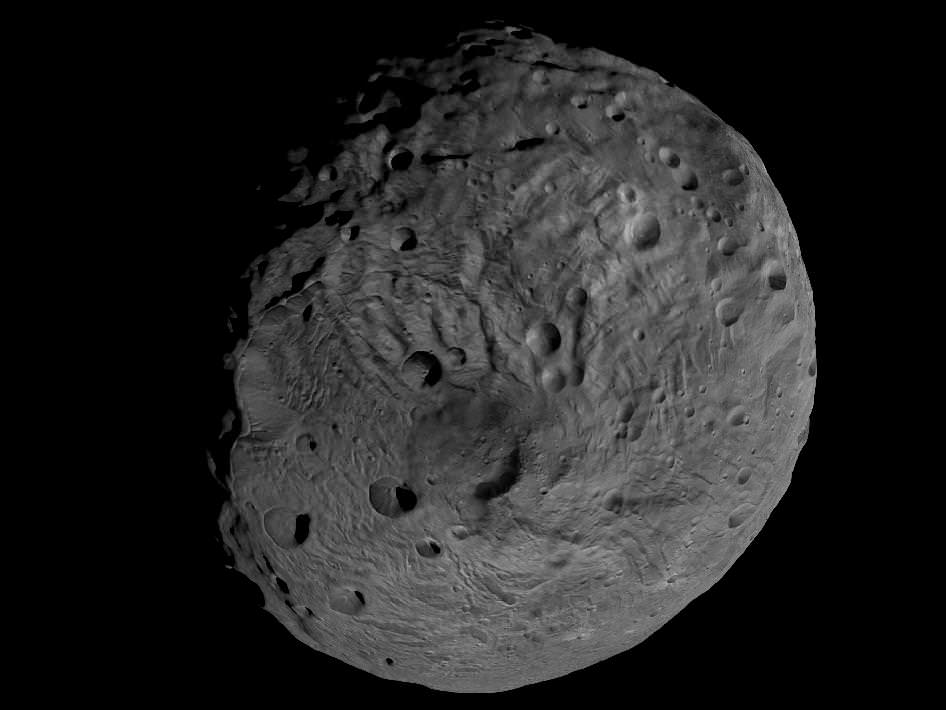
Viewing the South Pole of Vesta and Rhea Silvia Impact Basin. This image obtained by Dawn’s framing camera shows the south pole of the giant asteroid Vesta and the circular Rheasilvia impact basin which scientists believe originated by a collision with another asteroid early in the asteroid's history. The image was recorded from a distance of about 1,700 miles (2,700 kilometers). The image resolution is about 260 meters per pixel. Credit: NASA/JPL-Caltech/UCLA/MPS/DLR/IDA
[/caption]
The mysterious asteroid Vesta may well have more surprises in store. Despite past observations that Vesta would be nearly bone dry, newly published research indicates that about half of the giant asteroid is sufficiently cold and dark enough that water ice could theoretically exist below the battered surface.
Scientists working at NASA’s Goddard Space Flight Center in Greenbelt, Md., and the University of Maryland have derived the first models of Vesta’s average global temperatures and illumination by the Sun based on data obtained from the Hubble Space Telescope.
“Near the north and south poles, the conditions appear to be favorable for water ice to exist beneath the surface,” says Timothy Stubbs of NASA’s Goddard Space Flight Center in Greenbelt, Md., and the University of Maryland, Baltimore County. The research by Timothy Stubbs and Yongli Wang, of the Goddard Planetary Heliophysics Institute at the University of Maryland, was published in the January 2012 issue of the journal Icarus.
If any water lurks beneath Vesta, it would most likely exist at least 10 feet (3 meters) below the North and South poles because the models predict that the poles are the coldest regions on the giant asteroid and the equatorial regions are too warm. Global Map of Average Surface Temperature of Vesta
This global map of average surface temperature shows the warmer equatorial zone of the giant asteroid Vesta is likely too warm to sustain water ice below the surface. But roughly half of Vesta is so cold and receives so little sunlight on average that water ice could have survived there for billions of years. The dividing lines (solid gray) are found at about 27 degrees north latitude and 27 degrees south latitude. This map, with temperatures given in kelvins, comes from the first published models of the average global temperature and illumination conditions on Vesta. Credit: NASA/GSFC/UMBC
If proven, the existence of water ice at Vesta would have vast implications for the formation and evolution of the tiny body and upend current theories.
The surface of Vesta is not cold enough for ice to survive all the time because unlike the Moon, it probably does not have any significant permanently shadowed craters where water ice could stay frozen on the surface indefinitely.
Even the huge 300 mile diameter (480-kilometer) crater at the South Pole is not a good candidate for water ice because Vesta is tilted 27 degrees on its axis, a bit more than Earth’s tilt of 23 degrees.
By contrast, the Moon is only tilted 1.5 degrees and possesses many permanently shadowed craters. NASA’s LCROSS impact mission proved that water ice exists inside permanently shadowed lunar craters.
New modeling shows that, under present conditions, Vesta's polar regions are cold enough (less than about 145 kelvins) to sustain water ice for billions of years, as this map of average surface temperature around the asteroid's south pole indicates.
The models predict that the average annual temperature around Vesta’s poles is below minus 200 degrees Fahrenheit (145 kelvins). Water ice is not stable above that temperature in the top 10 feet of Vestan soil, or regolith.
At the equator and in a band stretching to about 27 degrees north and south in latitude, the average annual temperature is about minus 190 degrees Fahrenheit (145 kelvins), which is too high for the ice to survive.
“On average, it’s colder at Vesta’s poles than near its equator, so in that sense, they are good places to sustain water ice,” says Stubbs in a NASA statement. “But they also see sunlight for long periods of time during the summer seasons, which isn’t so good for sustaining ice. So if water ice exists in those regions, it may be buried beneath a relatively deep layer of dry regolith.”
Vesta is the second most massive asteroid in the main Asteroid belt between Mars and Jupiter.
NASA’s Dawn Asteroid Orbiter is the very first mission to Vesta and achieved orbit in July 2011 for a 1 year long mission.
Dawn is currently circling Vesta at its lowest planned orbit. The three science instruments are snapping pictures and the spectrometers are collecting data on the elemental and mineralogical composition of Vesta.
The onboard GRaND spectrometer in particular could shed light on the question of whether water ice exists at Vesta.
So far no water has been detected, but the best data is yet to come.
In July 2012, Dawn fires up its ion thrusters and spirals out of orbit to begin the journey to Ceres, the largest asteroid of them all.
Ceres is believed to harbor huge caches of water, either as ice or in the form of oceans and is a potential habitat for life.
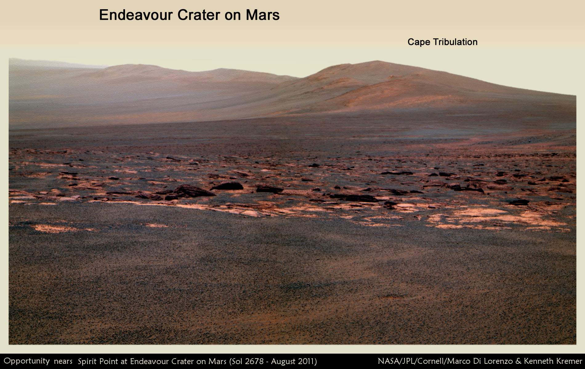
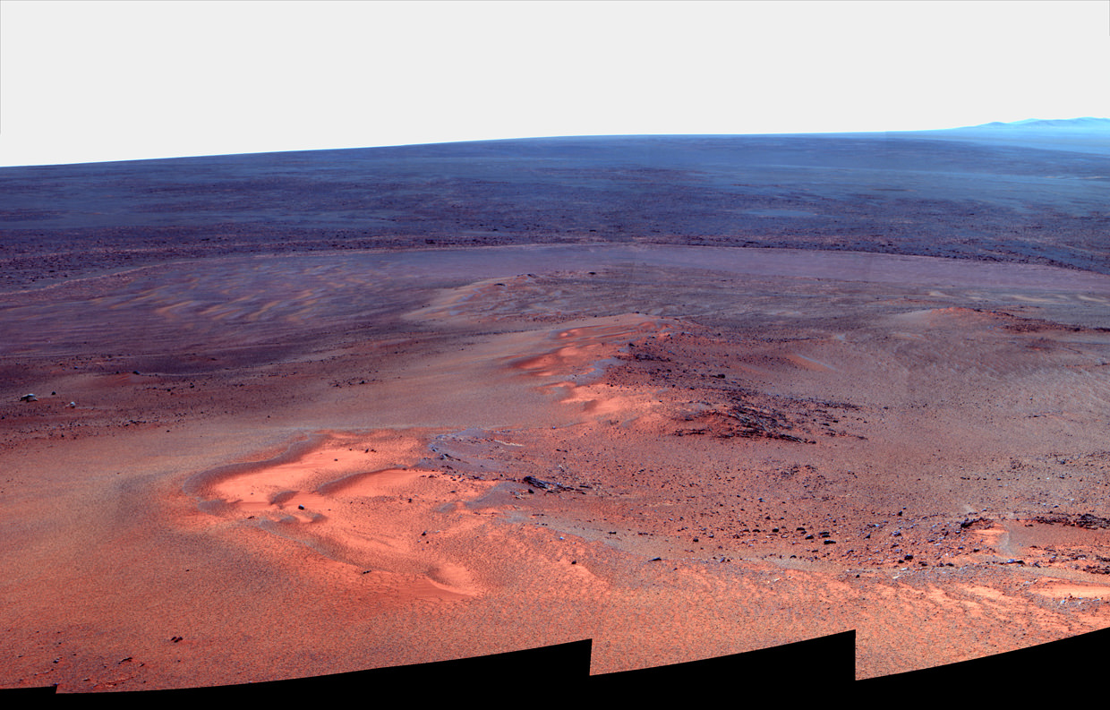
Martian Vista from Opportunity at Endeavour Crater - 8 Years on Mars. NASA’s Opportunity rover celebrated 8 Years on Mars on January 24, 2012. This mosaic shows portions of the segmented rim of Endeavour crater (14 miles, 22 km wide) after the robot arriving at the craters foothills in August 2011. Large ejecta blocks from a smaller nearby crater are visible in the middle. At Endeavour, Opportunity will investigate the oldest minerals deposits she has ever visited from billions of years ago and which may hold clues to environments that were potentially habitable for microbial life. The rover will eventually drive to Cape Tribulation at right after surviving her 5th winter on Mars. Mosaic Credit: NASA/JPL/Cornell/Marco Di Lorenzo/Kenneth Kremer
[/caption]
Today, the resilient Opportunity robot begins her 9th year roving around beautifully Earth-like Martian terrain where potentially life sustaining liquid water once flowed billions of years ago.
Opportunity celebrates her 8th anniversary on the Red Planet gazing at the foothills of the vast crater named Endeavour, promising a “mother lode” of “watery” science – an unimaginable circumstance since the nail biting landing on the hematite rich plains of Meridiani Planum on 24 January 2004.
“Opportunity is 97 months into the 3 month mission,” team members are proud and universally surprised to say.
“Milestones like 8 years on Mars always make me look forward rather than looking back,” Rover Principal Investigator Prof. Steve Squyres of Cornell University told Universe Today for this article commemorating Opportunity’s landing.
“We’ve still got a lot of exploring to do, but we’re doing it with a vehicle that was designed for a 90-sol mission. That means that every sol is a gift at this point.”
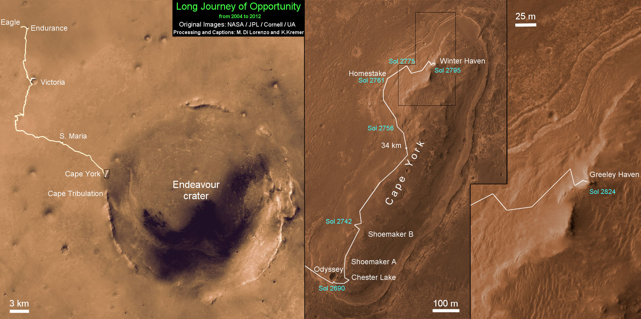
Opportunity has driven more than 21 miles (34 kilometers) across the Red Planet’s surface during what is truly humankind’s first overland expedition on another Planet. See our route map below.
Opportunity Rover Traverse Map at Meridiani Planum on Mars - 2004 to 2012
Traverse map shows the 8 Year Journey of Opportunity from Eagle Crater landing site on Sol 1- Jan. 24, 2004 - to 5th Winter Haven worksite at Greeley Haven at Endeavour Crater rim in January 2012. Opportunity embarked on a crater tour and discovered bountiful evidence for the flow of liquid water on Mars billions of years ago. The robot has shown that ancient ephemeral shallow lakes existed on Mars when the cratered terrain was cut by fluvial channels. Endeavour Crater is 14 miles (22 kilometers) in diameter. Opportunity has so far driven more than 21 miles (34 km) over 8 Years but was only expected to live for 90 Martian days. Credit: NASA/JPL/Cornell/UA/Marco Di Lorenzo/Kenneth Kremer
NASA’s twin rovers Spirit and Opportunity blasted off for Mars atop a pair of Delta II rockets in the summer of 2003 with a mission “warranty” of just 90 Martian days, or Sols.
Today is Sol 2846 of working operations for Opportunity, compared to an anticipated lifetime of only 90 Sols – that amounts to more than 31 times beyond the designer’s expectations.
Indeed, the long lived robot is now enduring her 5th Winter on Mars. And to glimpse the next Martian sunrise, the robo girls manmade components must survive the harsh extremes of frigid Antarctic-like temperatures each and every sol.
“I never thought that we would still be planning sequences for Opportunity today,” Ray Arvidson told Universe Today. Arvidson, of Washington University in St. Louis, is the deputy rover principal investigator.
“I seriously thought both Spirit and Opportunity would be finished by the summer of 2004.”
Opportunity's Eighth Anniversary View From 'Greeley Haven' (False Color). This mosaic of images taken in mid-January 2012 shows the windswept vista northward (left) to northeastward (right) from the location where Opportunity is spending its fifth Martian winter, an outcrop informally named "Greeley Haven. Credit: NASA/JPL-Caltech/Cornell/Arizona State Univ.
But, Opportunity is the gift to science that keeps on giving.
“I am feeling pretty good as the MER rover anniversaries approach,” Arvidson told me.
“Opportunity has shown that ancient ephemeral shallow lakes existed as Mars moved climatically from an early period when the cratered terrain was cut by fluvial channels to the current dry and cold conditions that dominate.”
“Both rovers have conclusively shown the need for lateral mobility to get to relevant outcrops and back out the secrets associated with past conditions,” Arvidson explained.
Barely a month ago the bountiful harvest from mobility was once again demonstrated when the science team lead by Squyres and Arvidson announced that Opportunity had discovered the most scientifically compelling evidence yet for the flow of liquid water on ancient Mars.
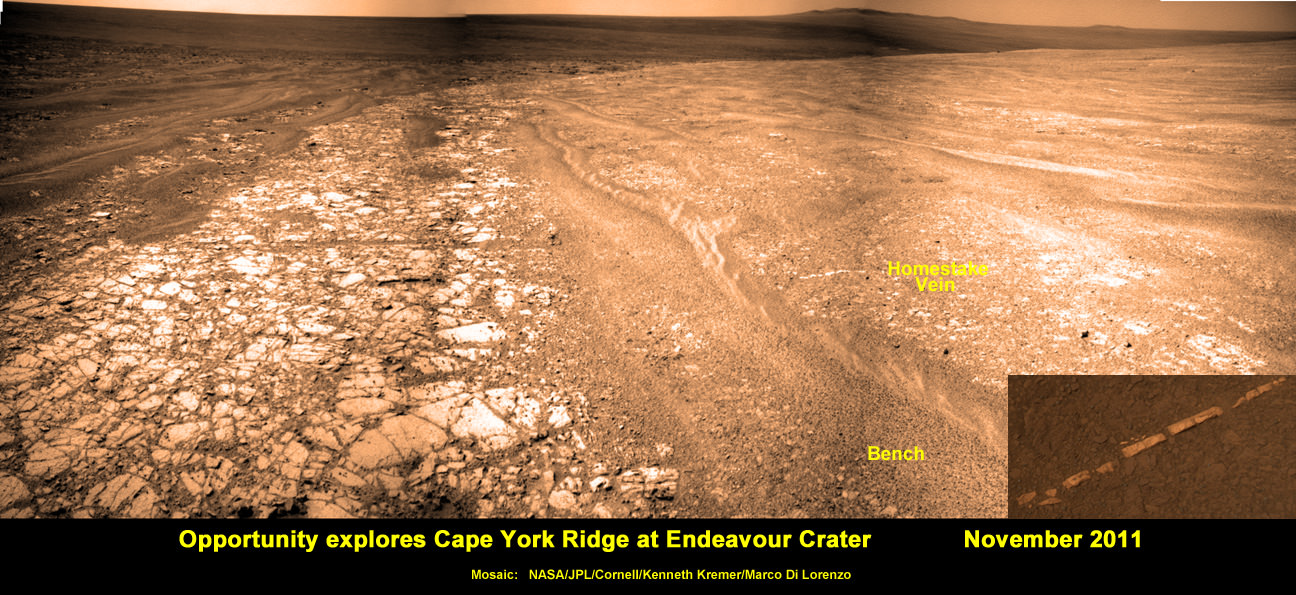
Squyres and Arvidson announced that Opportunity had found a bright vein – named “Homestake” – composed of the mineral gypsum located at the Cape York segment of Endeavour Crater where the intrepid robot is currently spending her 5th Martian Winter.
“This gypsum vein is the single most powerful piece of evidence for liquid water at Mars that has been discovered by the Opportunity rover,” Squyres explained.
Veins are a geologic indication of the past flow of liquid water.
See our mosaic below illustrating the exact location of the “Homestake” vein at Endeavour Crater – also published at Astronomy Picture of the Day; 12 Dec 2011.
Opportunity discovers Water related Mineral Vein at Endeavour Crater - November 2011
Opportunity rover discovered Gypsum at the Homestake mineral vein, while exploring around the base of Cape York ridge at the rim of Endeavour Crater. The vein is composed of calcium sulfate and indicates the ancient flow of liquid water at this spot on Mars. This panoramic mosaic of images was taken on Sol 2761, November 2011, and illustrates the exact spot of the mineral vein discovery.
Credit: NASA/JPL/Cornell/Kenneth Kremer/Marco Di Lorenzo
Published on Astronomy Picture of the Day (APOD): 12 Dec 2011
Opportunity just arrived at the rim of the 14 mile (22 kilometer) wide Endeavour Crater in mid-August 2011 following an epic three year trek across treacherous dune fields from her prior investigative target at the ½ mile wide Victoria Crater.
“It’s like a whole new mission since we arrived at Cape York,” says Squyres.
For the next few months of the bitterly cold Martian winter, Opportunity will conduct a vigorous science campaign while remaining mostly stationary at a spot dubbed “Greeley Haven” in honor of Prof. Ronald Greeley, a team member from Arizona State University who recently passed away.
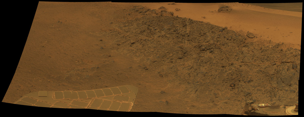
Opportunity Mars Rover at 5th Winter Worksite at Endeavour Crater
This mosaic shows the view of NASA’s Opportunity rover parked at “Greeley Haven” worksite where the robot will spend her 5th Martian Winter. This mosaic of images shows the Winter Haven view from the Cape York Ridge at the western rim of Endeavour Crater looking south along the crater rim. Tire tracks at right. Credit: NASA/JPL/Cornell/ Marco Di Lorenzo/Kenneth Kremer
At this moment Opportunity is snapping a 360 degree panorama, deploying her robotic arm onto nearby outcrops, collecting microscopic images, making measurements of mineral compositions with the Alpha Particle X-Ray Spectrometer and conducting radio science observations to elucidate the unknown structure of the Martian interior and core.
The rover is covered with a significant coating of dust which limits her ability to generate power from the life sustaining solar arrays. Since Opportunity is traversing just south of the equator, engineers have temporarily parked her on a northerly facing slope to maximize the electric power generation.
“Opportunity is currently sitting on an outcrop of impact breccias at Greeley Haven on Cape York,” said Arvidson.
Opportunity will remain at Greeley Haven until some time after the Winter Solstice of southern Martian winter occurs at the end of March. 'Greeley Haven' Site for Opportunity's Fifth Martian Winter. This mosaic of Greeley Haven was acquired by Opportunity on Sol 2793, Dec. 2, 2011. Credit: NASA/JPL-Caltech/Cornell/Arizona State Univ.
Then she’ll head south to further explore the veins and eventually drive to deposits of the clay mineral located a few miles (km) away along the craters rim.
“We’ll do good science while we’re at Greeley Haven. But as soon as we catch a wind gust or the seasons change, we’ll be on our way again,” Squyres told me.
The legendary twins Spirit and Opportunity surely rank as one of the greatest triumphs in space exploration.
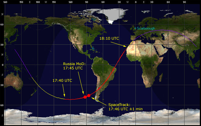
The map above shows the predicted trajectory of the Fobos-Grunt probe upon reentry. Russian space officials initially said the probe landed at one of the red dots, but later acknowledged that it could have touched down anywhere along the area indicated by the red line segment. Credit: Robert Christy, www.zarya.info
[/caption]
A week and a half after the re-entry of Russia’s Phobos–Grunt probe, experts have now made an official statement on their determination of where the spacecraft entered Earth’s atmosphere. But their report offers no information regarding if any pieces of the craft made it to Earth and where any remaining debris might be. Consequently, recovery of any pieces, including the Phobos-LIFE biomodule is highly unlikely.
“While this was an uncontrolled reentry, the location of the potential impact area was largely over ocean, with a correspondingly low probability of any detrimental effects,” said Prof. Heiner Klinkrad, Head of ESA’s Space Debris Office in Darmstadt, Germany.
The Inter-Agency Space Debris Coordination Committee (IADC) reports that Phobos–Grunt re-entered on January 15, 2012 at 17:46 GMT, at an altitude of 80 km at 46°S and 87°W, near the South American coastline. About 7 minutes later, the report says, the spacecraft’s altitude was 10 km.
“Within the expected uncertainties, the prediction has been largely confirmed by observations,” ESA’s press release stated.
And that is all the information the IADC has provided, with no details on whether those observations were from observers on the ground or from satellite and radar facilities.
In fact, most of the initial information verifying that Phobos-Grunt was no longer in orbit came from ground observations of not seeing the spacecraft in orbit over Europe after 18:00 UTC on January 15 when it was supposed to have a visible pass.
IADC members include NASA, Roscosmos, the European Space Agency, European national agencies and the space agencies of Canada, China, India, Japan and Ukraine. The group primarily used orbit data from the U.S. Space Surveillance Network and the Russian Space Surveillance System to determine Phobos-Grunt’s path to destruction. Radar systems in Germany and France also provided orbit calculations.
Phobos-Grunt orbiter and lander. Credit: ESA
Before re-entry, predictions from the various agencies differed widely, and initially after the probe was said to have re-entered, there was confusion on when and where the re-entry took place. Roscosmos initially released a statement claiming that the probe had fallen safely in the Pacific, off the coast of Chile, but later there were reports that fragments of the spacecraft had fallen in the south Atlantic Ocean. Officials said the confusion was due to the large number of uncertainties in the spacecraft’s orbit and the space environment affecting the satellite.
Indeed, everyone involved in re-entry calculations acknowledges the problematic nature of trying to monitor things in real-time, such as atmospheric density in the specific location the object is traveling. Most of the time, the details can only be deduced after the time of re-entry, and any unknowns can alter the projected re-entry and impact point by wide margins.
And so it is not entirely surprising that the IADC cannot offer much information beyond the initial entry point and time for Phobos-Grunt.
Although much of the Phobos-Grunt spacecraft was expected to disintegrate upon re-entry, Roscosmos said perhaps 20 to 30 fragments weighing a combined 200 kg (440 lb.) might survive and fall somewhere over a vast strip of the Earth’s surface between 51.4 deg. north and south of the equator.
The cause of the spacecraft’s malfunction has not yet been determined, and Roscosmos has indicated that a full report on the failure will be published on January 26, 2012, although an interim report said to be available by January 20 did not appear. The investigation is being conducted by Yuri Koptev, former head of the Russian Space Agency.
Shortly after launching from the Baikonur Cosmodrome on Nov. 9, 2011, the probe became stuck in low Earth orbit after its upper stage engines repeatedly failed to ignite to send the ship on an unprecedented sample return mission to Mars’ moon Phobos. Later, ESA tracking stations were instrumental in establishing short-lived contact with the probe, leading to hopes the spacecraft could be saved. But subsequent contact was not able to be made, and without contact and inputs from the ground, the spacecraft’s orbit disintegrated.
However, the story of Phobos-Grunt’s malfunctions and demise has included some wild claims ranging from accidental radar interference to outright sabotage, along with intimations of conspiracy theories.
Several times after the malfunction, Russian space officials suggested that US radar emissions may have accidently disabled the spacecraft; at first from a station in Alaska, and then — after it was pointed out that Phobos-Grunt had never flown over that location — another Russian official said it was perhaps radar from a military installation on Kwajalein Atoll in the Marshall Islands.
But these claims were later dismissed by a Russian scientist, Alexander Zakharov from the Russian Academy of Science Space Research Institute, who was involved with the development of Phobos-Grunt. He told the Russian news agency Ria Novosti that the radar theory is “far-fetched,” and suggested instead that issues with the spacecraft itself were likely to blame.
“You can come up with a lot of exotic reasons,” Zakharov told RIA Novosti. “But first you need to look at the apparatus itself. There are problems there,” and he indicated there may have been some known problems with the second stage of the rocket.
Later, after re-entry, links to Phobos-Grunt tracking data on the Space Track website were removed, fueling speculation of a conspiracy to hide in formation of where the probe fell. Space Track is a public website that ordinarily details such events, and is operated by U.S. Strategic Command. The military also did not publish any confirmation of the probe’s fall, which is not the usual protocol.
But later, the US Strategic Command said a human error had accidentally misfiled the information (in the 2011 files instead of 2012). Shortly after the error was discovered, the information was re-posted to the site and is accessible at this time.
The Planetary Society’s Living Interplanetary Flight Experiment (LIFE) capsule, on board the Phobos-Grunt spacecraft. Credit:The Planetary Society
Meanwhile, hopes dim for finding the capsule for the Phobos-LIFE biomodule which included organisms in a small capsule to test the “transpermia” hypothesis –- the possibility that life can travel from planet to planet inside rocks blasted off one planetary surface by impact, to land on another planetary surface. The biomodule would have flown to Phobos and then returned to Earth with the sample return capsule of the Phobos-Grunt spacecraft.
“Because we can’t predict the details of the re-entry, we can’t predict whether the Phobos LIFE biomodule will survive, and certainly we can’t predict whether it will land somewhere it could be recovered,” said Bruce Betts from The Planetary Society, which sponsored the LIFE mission. “In the unlikely event the Phobos LIFE biomodule is recovered, we would want to study the organisms inside. Though not the long deep space experience we had hoped for, there still will be scientific value to study of the organisms even after just two months in low Earth orbit.”
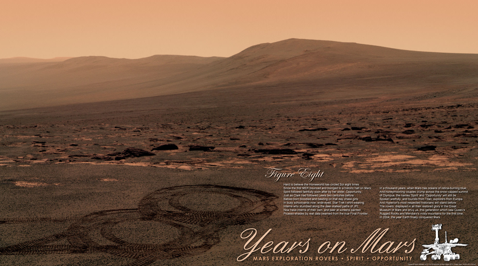
8 years ago today, January 24, the Opportunity rover landed on Mars. In what has become a tradition, Stu Atkinson and Astro0 from Unmanned Spaceflight have teamed up to create a poster and poem combo to celebrate the occasion. While we fondly remember Spirit’s now-finished journey, the poster features scenes from Opportunity’s view of the ‘Tribulation’ hill and the hills of the crater rim beyond. And no, Oppy didn’t actually spin out in double donuts on Mars to create the ‘figure 8.’
“For a little effect, we’ve added the ‘figure 8’ in the form of the rovers own tracks on Mars,” Astro0 said. “While they may have dreamed of doing it, I’m sure no rover driver would ever be tempted to leave such a mark on Mars for real. So it was only right and proper that I and Photoshop do it for them.”
Click on the image above for a larger version or visit the Astro0 website for higher resolution versions that you can download to print out as a poster or use for your computer wallpaper. Stu’s poem — which both waxes wistful about the year of the MER rovers landing and prognosticates Mars’ future — is written out below:
8 Years on Mars
Hard to believe the Homeworld has circled Sol eight times
Since the first MER bounced and boinged to a historic halt on Mars,
Spirit followed faithfully soon after by her sister, Opportunity,
Just as Clark had followed Lewis two centuries before.
Babies born bloodied and bawling on the day chase girls
In busy schoolyards now; wide-eyed, Star Trek t-shirt wearing
Interns who stumbled along the deer-stalked paths of JPL
Now have interns of their own, and peer at screens painted
Picasso-shades by read date beamed from the true Final Frontier…
In a thousand years, when Mars has oceans of retina-burning blue,
And honeymooning couples crump across the snow-capped summit
Of Olympus, the names ‘Spirit’ and ‘Opportunity’ will still be
Spoken wistfully; and tourists from Titan, explorers from Europa
And Hyperion’s most respected historians will stand before
The rovers, displayed in all their restored gory in the Great
Museum of Mars and envy us, this generation which saw Gusev’s
Rugged Rocks and Meridiani’s misty mountains for the first time,
In 2004, the year Earth finally conquered Mars.
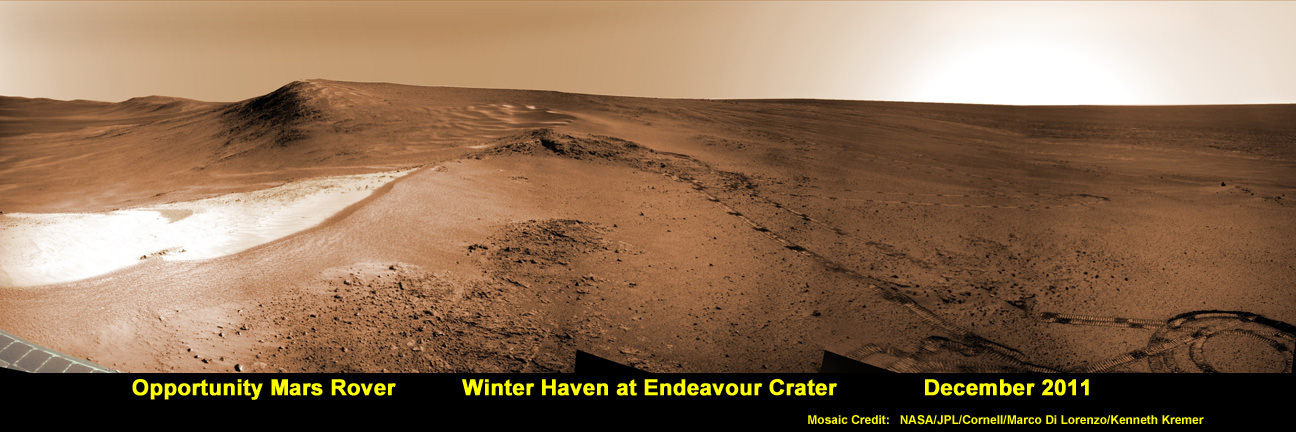
Opportunity Mars Rover at Winter Haven Worksite at Endeavour Crater. NASA’s Opportunity rover has parked near this spot at the “Greeley Haven” worksite where the robot will spend her 5th Martian Winter Haven since landing 8 years ago in January 2004. This mosaic of images was snapped in December 2011 and shows the view from the Cape York Ridge at the western rim of Endeavour Crater looking south along the crater rim to a future area that Opportunity will drive to and explore next spring. Credit: NASA/JPL/Cornell/ Marco Di Lorenzo/Kenneth Kremer
[/caption]
NASA’s seemingly indestructible Opportunity rover has arrived at the breathtaking location where she’ll be working through her unfathomable 5th Martian Winter. The Opportunity Mars Exploration Rover has not only endured, but flourished for 8 years of unending “Exploration & Discovery” on the Red Planet despite having an expected lifetime at landing of just 3 months, way back in January 2004.
Opportunity is parked at a northward facing outcrop dubbed “Greeley Haven” where she can soak up the sun and juice her innards throughout the utterly harsh and Antarctic-like temperatures on tap for the next few months that threaten to kill her each and every Martian day. See our mosaic above around the Greeley Haven area.
Science team members told Universe Today that the rover is sitting at Greeley Haven because the site offers a roughly 15 degree tilt that will maximize the electric output from the life-giving solar arrays and also allow the robot to carry out a vigorous science campaign during the seasonal Martian winter season that officially begins in March.
Greeley Haven is a located at the northern tip of the “Cape York” segment of the western rim of the vast crater named Endeavour, some 14 miles (22 km) wide that’s loaded with a bountiful variety of rocks and soil that neither Opportunity nor her twin Spirit have ever touched and drilled into before and stem from an earlier epoch when liquid water flowed eons ago and perhaps may have been more favorable to sustaining life.
“Opportunity is currently sitting on Saddleback at Greeley Haven, an outcrop of impact breccias on Cape York, Endeavour crater’s rim,” Ray Arvidson told Universe Today. Arvisdon is the mission’s deputy principal investigator, of Washington University in St. Louis.
“Her northerly tilt is about ~15 degrees which is enough to have a vibrant winter campaign. The Martian southern winter solstice occurs at the end of March. A few months after that date we will drive her off the outcrop and further explore Cape York.”
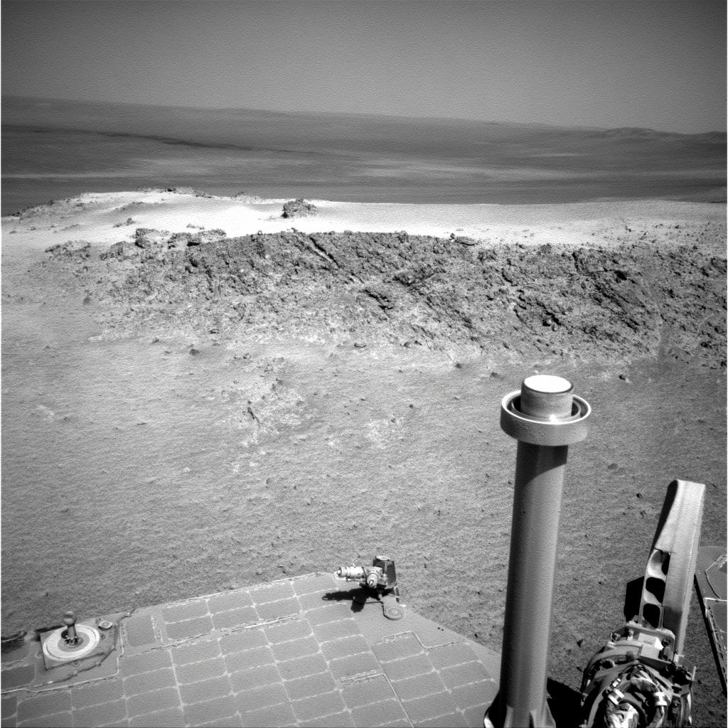
Approaching 'Greeley Haven' on Endeavour Rim
Opportunity captured this view of a northward-facing outcrop, "Greeley Haven," where the rover will work during its fifth Martian winter. This southward-looking image was taken on Sol 2790 on Mars (Nov. 29, 2011). The rover team chose this designation as a tribute to the influential planetary geologist Ronald Greeley (1939-2011), who was a member of the science team for the Mars rovers and many other interplanetary missions. Credit: NASA/JPL-Caltech
“Greeley Haven” is named in tribute to planetary Geologist Ronald Greeley (1939-2011) who was a beloved member of the rover science team and a host of other NASA planetary missions. He taught at Arizona State University and inspired several generations of students and planetary scientists until his recent death on Oct. 27, 2011.
“We’ll hunker down at Greeley Haven as long as we need to, and we’ll do good science while we’re there,” Steve Squyres of Cornell University, Ithaca, N.Y., told Universe Today. Squyres is the Principal Investigator for Opportunity.
Opportunity is collecting a high resolution 360 degree panorama to commemorate Greeley.
Throughout the past 4 Martian winters, Opportunity had continued to traverse without pause. But this winter time it’s different because the solar panels are significantly more coated with an obscuring layer of dust hindering their energy output.
So the rover is parked with a tilt for her 5th Martian winter, mimicking the successful strategy power boosting used by Spirit to survive 3 harsh Martian winters.
And there is a silver lining to sitting mostly still that enables a chance to determine what’s at the core of the Red Planet, a key fact we don’t know.
“This winter science campaign will feature two way radio tracking with Earth to determine the Martian spin axis dynamics – thus the interior structure, a long-neglected aspect of Mars,” Arvidson told me.
I asked Squyres for a progress update and how long would the data collection require ?
Squyres replied that the experiment has already begun and added – “Hard to say how long. It’s months, as opposed to weeks or years, but it depends very much on data quality and the amount of data we get per week. We’re very early in the experiment now… we’ll just see how it goes.”
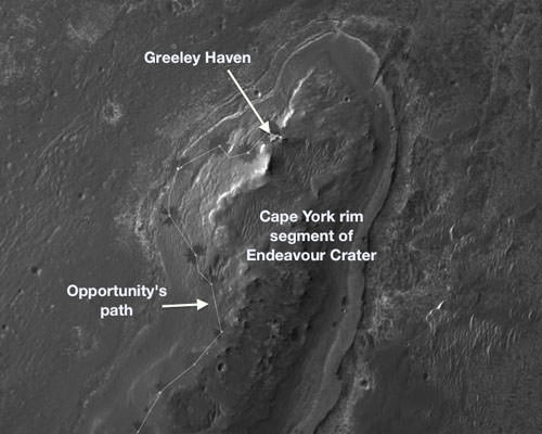
Locator Map for 'Greeley Haven' on Endeavour Crater Rim
Opportunity will spend its fifth Martian winter working at Greeley Haven on the western rim of Endeavour Crater. Credit: NASA/JPL-Caltech/UA
Three Generations of Mars Rovers in the Mars Yard. This grouping shows 3 generations of NASA’s Mars rovers from 1997 to 2012 set inside the Mars Yard at the Jet Propulsion Lab in Pasadena, Calif. The Mars Pathfinder Project (front) landed the first Mars rover - Sojourner - in 1997. The Mars Exploration Rover Project (left) landed Spirit and Opportunity on Mars in 2004. The Mars Science Laboratory Project (right) is on course to land Curiosity on Mars in August 2012. Credit: NASA/JPL-Caltech
[/caption]
NASA Mars rovers have come a long way in terms of size and capability since the rebirth of Red Planet surface exploration just 15 years ago – spanning from 1997 to 2012.
To get a really excellent sense of just how far America’s scientists and engineers have pushed the state of the art in such a short time – when the willpower and funding existed and coincided to explore another world – take a good look at the new pictures here showing 3 generations of NASA’s Mars rovers; namely Mars Pathfinder (MPF), the 1st generation Mars rover, Mars Exploration Rover (MER), the 2nd generation, and Mars Science Laboratory (MSL), the 3rd and newest generation Mars rover.
The newly released pictures graphically display a side by side comparison of the flight spare for Mars Pathfinder (1997 landing) and full scale test rovers of the Mars Exploration Rover (2004 landing) and Mars Science Laboratory (in transit for a 2012 planned landing). The setting is inside the “Mars Yard” at NASA’s Jet Propulsion Laboratory, Pasadena, Calif. where the teams conduct mission simulations.
It’s been nothing less than a quantum leap in advancement of the scientific and technological capability from one generation to the next.
Sojourner - NASA’s 1st Mars Rover
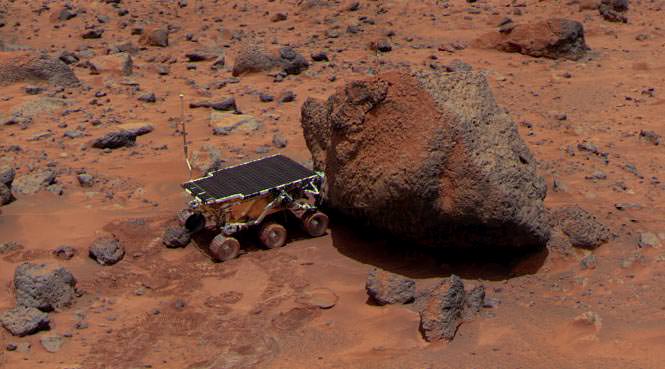
Sojourner takes an Alpha Proton X-ray Spectrometer (APXS) measurement of Yogi rock after Red Planet landing on July 4, 1997 landing. Sojourner was only 2 feet long, the size of a microwave oven.
Credit: NASA
Just consider the big increase in size – growing from a microwave oven to a car !
The “Marie Curie” flight spare and the actual “Sojourner” rover on Mars are 2 feet (65 centimeters) long – about the size of a microwave oven. The MER rovers “Spirit and Opportunity” and the “Surface System Test Bed” rover are 5.2 feet (1.6 meters) long – about the size of a golf cart. The MSL “Curiosity” and the “Vehicle System Test Bed” rover are 10 feet (3 meters) long – about the size of a car.
Side view of Three Generations of Mars Rovers
Front; flight spare for the first Mars rover, Sojourner. Left; Mars Exploration Rover Project test rover. Right; Mars Science Laboratory test rover Credit: NASA/JPL-Caltech
With your own eyes you can see the rapid and huge generational change in Mars rovers if you have the opportunity to visit the Kennedy Space Center Visitor Complex and stroll by the Mars exhibit with full scale models of all three of NASA’s Red Planet rovers.
At the KSC Visitor Complex in Florida you can get within touching distance of the Martian Family of Rovers and the generational differences in size and complexity becomes personally obvious and impressive.
NASA’s Family of Mars rovers at the Kennedy Space Center
Full scale models on display at the Kennedy Space Center Visitor Complex. Curiosity and Spirit/Opportunity are pictured here. Sojourner out of view. Credit: Ken Kremer
All of the Mars rovers blasted off from launch pads on Cape Canaveral Air Force Station, Florida.
Sojourner, Spirit and Opportunity launched atop Delta II rockets at Space Launch Complex 17 in 1996 and 2003. Curiosity launched atop an Atlas V at Space Launch Complex 41 in 2011.
Three Generations of Mars Rovers with Standing Mars Engineers
The rovers are pictured here with real Mars Engineers to get a sense of size and perspective. Front rover is the flight spare for the first Mars rover, Sojourner. At left is a Mars Exploration Rover Project test rover, working sibling to Spirit and Opportunity. At right is a Mars Science Laboratory test rover the size of Curiosity which is targeting a August 2012 Mars landing. The Mars engineers are JPL's Matt Robinson, left, and Wesley Kuykendall. Credit: NASA/JPL-Caltech
Opportunity is still exploring Mars to this day – 8 years after landing on the Red Planet, with a warranty of merely 90 Martian days.
Curiosity is scheduled to touch down inside Gale crater on 6 August 2012.
So, what comes next ? Will there be a 4th Generation Mars rover ?


 capsule, on board the Phobos-Grunt spacecraft. Credit:The Planetary Society")