In Fact It’s Cold As Hell: Mars Isn’t As Earthlike As It Might Look

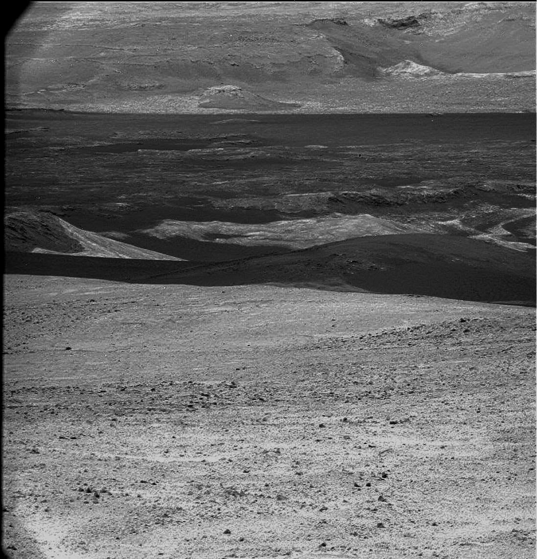
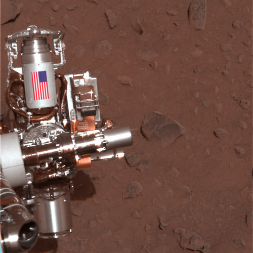
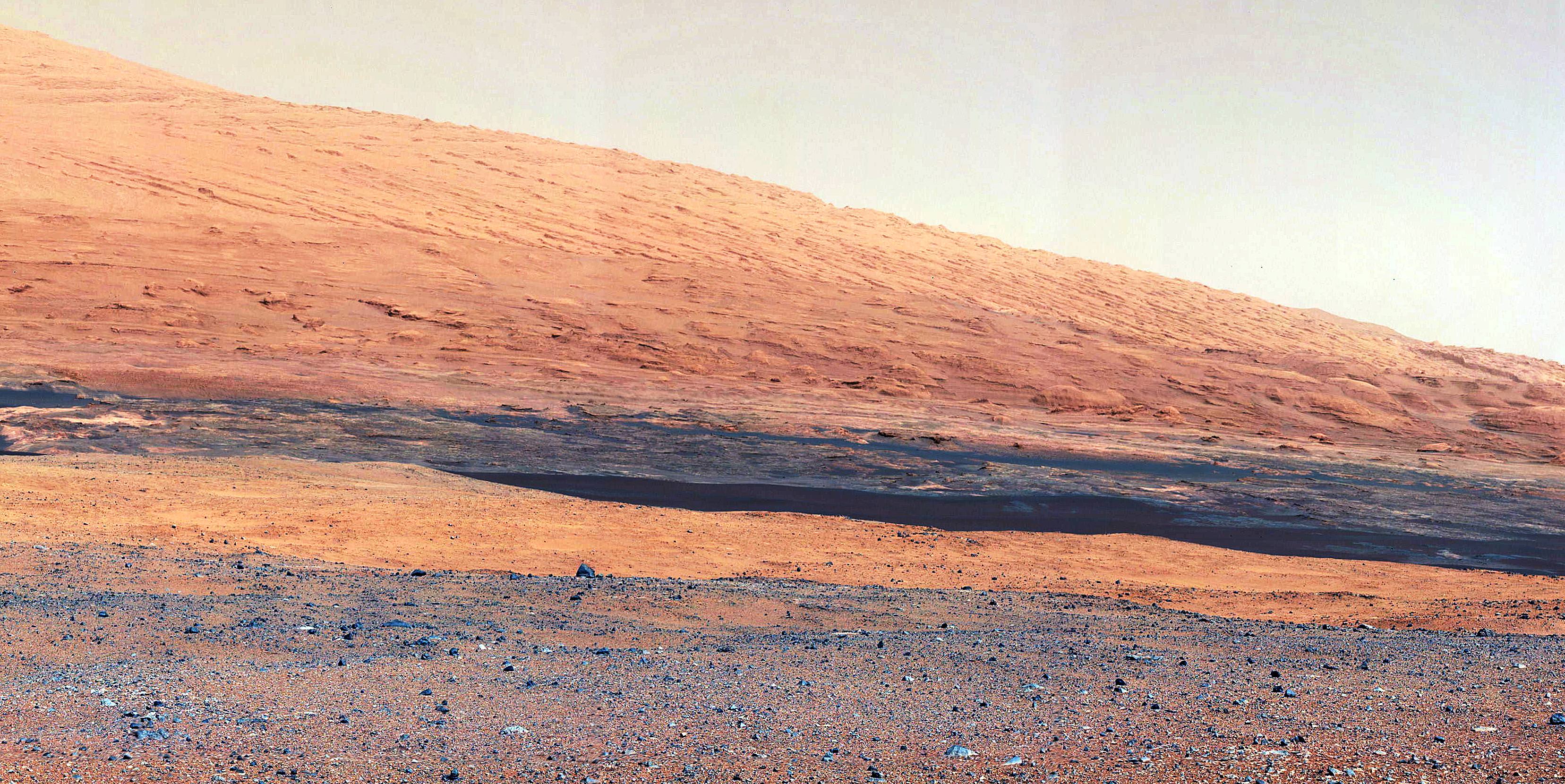
The slopes of Gale Crater as seen by Curiosity are reminiscent of the American southwest (NASA/JPL-Caltech)

“Mars ain’t no kind of place to raise your kids; in fact it’s cold as hell” sang Elton John in “Rocket Man”, and although the song was released in 1972 — four years before the first successful landing on Mars — his weather forecast was spot-on. Even though the fantastic images that are being returned from NASA’s Curiosity rover show a rocky, ruddy landscape that could easily be mistaken for an arid region of the American Southwest one must remember three things: this is Mars, we’re looking around the inside of an impact crater billions of years old, and it’s cold out there.

Mars Exploration Program blogger Jeffrey Marlow writes in his latest “Martian Diaries” post:

Over the first 30 sols, air temperature has ranged from approximately -103 degrees Fahrenheit (-75 Celsius) at night to roughly 32 degrees Fahrenheit (0 Celsius) in the afternoon. Two factors conspire to cause such a wide daily range (most day-night fluctuations on Earth are about 10 to 30 degrees Fahrenheit). The martian atmosphere is very thin; with fewer molecules in the air to heat up and cool down, there’s more solar power to go around during the day, and less atmospheric warmth at night, so the magnitude of temperature shifts is amplified. There is also very little water vapor; water is particularly good at retaining its heat, and the dryness makes the temperature swings even more pronounced. 

In that way Mars is like an Earthly desert; even after a blisteringly hot day the temperatures can plummet at night, leaving an ill-prepared camper shivering beneath the cold glow of starlight. Except on Mars, where the Sun is only 50% as bright as on Earth and the atmosphere only 1% as dense, the nighttime lows dip to Arctic depths.

“Deserts on Earth have very extreme temperature ranges,” says Mars Science Laboratory Deputy Project Scientist, Ashwin Vasavada. “So if you take a desert on Earth and put it in a very thin atmosphere 50% farther from the Sun, you’d have something like what we’re seeing at Gale Crater.”

And although the afternoon temperatures in Gale may climb slightly above freezing that doesn’t mean liquid water will be found pooling about in any large amounts. Curiosity’s in no danger from flash floods on Mars… not these days, anyway.

With atmospheric pressure just above water’s thermodynamic triple point, and temperatures occasionally hovering around the freezing point, it is likely that local niches are seeing above-zero temperatures, and Vasavada acknowledges, “liquid water could exist here over a tiny range of conditions.” But don’t expect a Culligan water plant in Gale Crater any time soon. “We wouldn’t expect for Curiosity to see liquid water, because it would evaporate or re-freeze too quickly,” explains Vasavada. “With so little water vapor in the atmosphere, any liquid water molecules on the surface would quickly turn to gas.”

So when on Mars, drink your coffee quickly. (And pack a blanket.)

“Gale Crater may look like the dusty, basaltic basins of the American southwest, but one look at the thermometer will send you running for the winter coat.”

– Jeffrey Marlow, Martian Diaries

Read Marlow’s full article here.

Image: Sunset on Mars seen by the MER Spirit from Gusev Crater in 2005 (NASA/JPL-Caltech)

Say Ahhh to Mars

Take a deep breath because this new panorama from Mars enthusiast Stu Atkinson will take it away.

“Anyway, a whole bunch of these came down, like I said, and to my delight they all linked up to form a big, biiiiiiiig panoramic mosaic,” said Stu on his blog “The Gale Gazette.” “And here it is. Obviously you’ll need to click on it to enlarge it… and I’ll warn you, it’s a big image, you can kiss the next few minutes goodbye because you’ll be panning around it for a while…”

Zoom in and you can see actual rocks. Click that little button at the right of the toolbar and Mars will take over your screen.

So far, Curiosity has rolled across a barely dusty plain in Gale Crater. Here’s a look of things to come. In black-and-white image from Curiosity, there appear to be big dunes to cross to get to the foothills of Aeolis Mons, or Mount Sharp.

A black-and-white but still breathtaking view of the dusty terrain between Curiosity’s current location and the foothills of Aeolis Mons, or Mount Sharp. Credit: NASA/JPL/Stu Atkinson

Curiosity has nearly finished robotic arm tests. Once complete, the rover will be able to touch and examine its first Mars rock.

“We’re about to drive some more and try to find the right rock to begin doing contact science with the arm,” said Jennifer Trosper, Curiosity mission manager at NASA’s Jet Propulsion Laboratory in Pasadena, Calif, in a press release.

This image from NASA’s Curiosity rover shows the open inlet where powered rock and soil samples will be funneled down for analysis. It was taken by the Mars Hand Lens Imager (MAHLI) on Curiosity’s 36th Martian day, or sol, of operations on Mars (Sept. 11, 2012). MAHLI was about 8 inches (20 centimeters) away from the mouth of the Chemistry and Mineralogy (CheMin) instrument when it took the picture. The entrance of the funnel is about 1.4 inches (3.5 centimeters) in diameter. The mesh screen is about 2.3 inches (5.9 centimeters) deep. The mesh size is 0.04 inches (1 millimeter). Once the samples have gone down the funnel, CheMin will be shooting X-rays at the samples to identify and quantify the minerals.

Engineers and scientists use images like these to check out Curiosity’s instruments. This image is a composite of eight MAHLI pictures acquired at different focus positions and merged onboard the instrument before transmission to Earth; this is the first time the MAHLI performed this technique since arriving at Curiosity’s field site inside Gale Crater. The image also shows angular and rounded pebbles and sand that were deposited on the rover deck during landing on Aug. 5, 2012 PDT (Aug. 6, 2012 EDT).

Two science instruments, a camera called Mars Hand Lens Imager, or MAHLI, that can take close-up color images and a tool called Alpha Particle X-ray Spectrometer (APXS) that can determine the elemental composition of a rock, also have passed tests. The instruments are mounted on a turret at the end of the robotic arm and can be placed in contact with target rocks. The adjustable focus MAHLI camera produced images this week of objects near and far; of the underbelly of Curiosity, across inlet ports and a penny that serves as a calibration target on the rover.

This close-up image shows tiny grains of Martian sand that settled on the penny that serves as a calibration target on NASA’s Curiosity rover. The larger grain under Abraham Lincoln’s ear is about 0.2 millimeters across. The grains are classified as fine to very fine sand.

The Mars Hand Lens Imagery (MAHLI) on the Curiosity rover taken by the Mast Camera on the 32nd Martian day, or sol, of operations on the surface. Engineers imaged MAHLI to inspect the dust cover and to ensure that the tool’s LED lights are functional. Scientists enhanced the image to show the scene as it would appear under Earth’s lighting conditions. This helps in analyzing the background terrain.

Check out more images from the Mars Science Laboratory teleconference.

Image credit: NASA/JPL-Caltech/MSSS

Opportunity Rover Finds Intriguing New Spherules at Cape York

Mosaic image of the spherules in the rock outcrop on Cape York at Endeavour crater. Credit: NASA / JPL-Caltech / Stuart Atkinson

One of the most interesting discoveries made so far by the Opportunity rover on Mars has been the small round spherules or “blueberries” as they are commonly referred to, covering the ground at the rover’s landing site. Typically only a few millimetres across, some lie loose on the soil while others are imbedded in rock outcrops.

Analysis by Opportunity indicates that they are most likely a type of concretion, which are also found on Earth. These Martian concretions have been found to contain the mineral hematite, which explains its detection in this region from orbit, and one of the main reasons that the rover was sent to this location in Meridiani Planum in the first place. They are similar to the Moqui Marbles, iron-oxide concretions in the outcrops of Navajo Sanstone in Utah, which formed in groundwater.

Now, the rover (eight years later and still going!) has found what may be a different type of spherule. These ones generally resemble the previous ones, but are quite densely packed in an unusual rock outcrop that is on the eastern side of Cape York, the small island-like ledge on the rim of the huge Endeavour crater. With brittle-looking “fins” of material, the outcrop is an an area that from orbit has been identified as containing small clay deposits. There are also more substantial clay deposits farther south along Endeavour’s rim at the much larger Cape Tribulation, the next major destination of Opportunity.

Whether this outcrop actually has any clay in it isn’t known yet, but the examination of it by Opportunity continues at the time of this writing. Some spherules have apparently broken off the outcrop, exposing their inside structure. The new close-up images of the spherules were taken by the Microscopic Imager (MI) on the rover.

A portion of the rock outcrop. Credit: NASA / JPL-Caltech / Stuart Atkinson

What makes these spherules of interest is the possibility that they may be connected somehow to the clay deposits. Their dense concentration in the outcrop and the physical nature of the outcrop itself may indicate a different origin than the other spherules seen previously, as well as the fact that no hematite signature has been seen from orbit in this specific area (although there may be smaller amounts of hematite here as well). We will just have to wait for the results of the rover’s analysis to come back, but they should be interesting.

Opportunity is specifically looking for the clay deposits in this area, as they could have formed in non-acidic (or pH neutral) water as often happens on Earth. As we have seen in just the last few days though, the origin of Martian clays is itself still a subject of debate.

The whitish gypsum veins already seen at Cape York and examined by Opportunity also indicate the presence of liquid water at this location in the distant past. There are some interesting light-coloured veins in this same outcrop as well; whether they are also gypsum or something else isn’t known yet.

Thanks also to Stuart Atkinson for his excellent mosaic images made from the original Opportunity photos.

Sputtering: How Mars May Have Lost Its Atmosphere

Artist depiction of the MAVEN spacecraft. Credit: NASA

Why is Mars cold and dry? While some recent studies hint that early Mars may have never been wet or warm, many scientists think that long ago, Mars once had a denser atmosphere that supported liquid water on the surface. If so, Mars might have had environmental conditions to support microbial life. However, for some reason, most of the Martian atmosphere was lost to space long ago and the thin wispy atmosphere no longer allows water to be stable at the surface. Scientists aren’t sure how or why this happened, but one way a planet can lose its atmosphere is through a process called ‘sputtering.’ In this process, atoms are knocked away from the atmosphere due to impacts from energetic particles.

Since Mars doesn’t have a strong intrinsic magnetic field, the atmosphere could have been eroded by interactions with the solar wind, and this video shows how that occurs. Also, the conditions in the early solar-system conditions enhanced the sputtering loss, and so the loss of Martian atmosphere could be caused by a complex set of mechanisms working simultaneously.

An upcoming mission could tell us what happened to Mars’ atmosphere. The Mars Atmosphere and Volatile Evolution spacecraft or MAVEN is equipped with eight different sensors designed to sort out what happened to the planet’s atmosphere.

MAVEN will be the first spacecraft ever to make direct measurements of the Martian atmosphere, and is the first mission to Mars specifically designed to help scientists understand the past – also the ongoing — escape of CO2 and other gases into space. MAVEN will orbit Mars for at least one Earth-year, about a half of a Martian year. MAVEN will provide information on how and how fast atmospheric gases are being lost to space today, and infer from those detailed studies what happened in the past.

Studying how the Martian atmosphere was lost to space can reveal clues about the impact that change had on the Martian climate, geologic, and geochemical conditions over time, all of which are important in understanding whether Mars had an environment able to support life.

The MAVEN will carry eight science instruments that will take measurements of the upper Martian atmosphere during one Earth year, equivalent to about half of a Martian year.

MAVEN is scheduled to launch in 2013, with a launch window from Nov. 18 to Dec 7, 2013. Mars Orbit Insertion will be in mid-September2014.

It Only Happens on Mars: Carbon Dioxide Snow is Falling on the Red Planet

Observations by NASA’s Mars Reconnaissance Orbiter have detected carbon-dioxide snow clouds on Mars and evidence of carbon-dioxide snow falling to the surface. Image credit: NASA/JPL-Caltech

In 2008, we learned from the Phoenix Mars lander that it snows in Mars northern hemisphere — perhaps quite regularly – from clouds made of water vapor. But now, Mars Reconnaissance Orbiter data has revealed the clearest evidence yet of carbon-dioxide snowfalls on Mars. Scientists say this is the only known example of carbon-dioxide snow falling anywhere in our solar system.

“These are the first definitive detections of carbon-dioxide snow clouds,” said Paul Hayne from the Jet Propulsion Laboratory, lead author of a new study published in the Journal of Geophysical Research. “We firmly establish the clouds are composed of carbon dioxide — flakes of Martian air — and they are thick enough to result in snowfall accumulation at the surface.”

Scientists have known for decades that carbon-dioxide exists in ice in Mars’ seasonal and permanent southern polar caps. Frozen carbon dioxide, sometimes called “dry ice” here on Earth, requires temperatures of about -125 Celsius (- 193 degrees Fahrenheit), which is much colder than needed for freezing water.

Even though we like to think Mars is a lot like Earth, findings like this remind us that Mars is indeed quite different. But just as the water-based snow falls during the winter in Mars’ northern hemisphere, the CO2 snowfalls occurred from clouds around the Red Planet’s south pole during winter in the southern hemisphere.

“Swiss Cheese Terrain” on Mars South Pole residual CO2 ice cap. Credit: NASA/JPL/University of Arizona

Hayne and six co-authors analyzed data gained by looking at clouds straight overhead and sideways with the Mars Climate Sounder, one of six instruments on the Mars Reconnaissance Orbiter. This instrument records brightness in nine wavebands of visible and infrared light as a way to examine particles and gases in the Martian atmosphere. The analysis was conducted while Hayne was a post-doctoral fellow at the California Institute of Technology in Pasadena.

The data provide information about temperatures, particle sizes and their concentrations. The new analysis is based on data from observations in the south polar region during southern Mars winter in 2006-2007, identifying a tall carbon-dioxide cloud about 500 kilometers (300 miles) in diameter persisting over the pole and smaller, shorter-lived, lower-altitude carbon dioxide ice clouds at latitudes from 70 to 80 degrees south.

“One line of evidence for snow is that the carbon-dioxide ice particles in the clouds are large enough to fall to the ground during the lifespan of the clouds,” co-author David Kass of JPL said. “Another comes from observations when the instrument is pointed toward the horizon, instead of down at the surface. The infrared spectra signature of the clouds viewed from this angle is clearly carbon-dioxide ice particles and they extend to the surface. By observing this way, the Mars Climate Sounder is able to distinguish the particles in the atmosphere from the dry ice on the surface.”

Mars’ south polar residual ice cap is the only place on the Red Planet where frozen carbon dioxide persists on the surface year-round. Just how the carbon dioxide from Mars’ atmosphere gets deposited has been in question. It is unclear whether it occurs as snow or by freezing out at ground level as frost. These results show snowfall is especially vigorous on top of the residual cap.

“The finding of snowfall could mean that the type of deposition — snow or frost — is somehow linked to the year-to-year preservation of the residual cap,” Hayne said.

Images from the Phoenix lander show water vapor clouds on Mars are producing snow.  Credit:  NASA/JPL-Caltech/University of Arizona/Texas A&M University
Clouds on Mars are producing snow. Credit: NASA/JPL-Caltech/University of Arizona/Texas A&M University

In 2008, science teams from the Phoenix mission were able to observe water-ice clouds in the Martian atmosphere and precipitation that fell to the ground at night and sublimate into water in the morning. Phoenix scientist James Whiteway and his colleagues said that clouds and precipitation on Mars play a role in the exchange of water between the ground and the atmosphere and when conditions are right, snow falls regularly on Mars.

“Before Phoenix we did not know whether precipitation occurs on Mars,” Whiteway said. “We knew that the polar ice cap advances as far south as the Phoenix site in winter, but we did not know how the water vapor moved from the atmosphere to ice on the ground. Now we know that it does snow, and that this is part of the hydrological cycle on Mars.”

It will be interesting to follow up on this discovery and learn more about Mars CO2 cycle and how it might affect the Martian atmosphere and surface processes.

Source: NASA

A Memorial to 9/11… on Mars

Today, on the 11th anniversary of the World Trade Center attack, countless hearts and minds will be reflecting upon a day that changed our world forever and remembering those who lost their lives in the tragic collapse of the twin towers. Memorial events will be held in many locations around the planet… and even, in a small yet poignant way, on another planet. For, unknown to many, two pieces of the World Trade Center are currently on the surface of Mars: one affixed to the rover Spirit, now sitting silently next to a small rise dubbed “Home Plate”, and the other on its sister rover Opportunity, still actively exploring the rim of Endeavour crater.

Even more than scientific exploration tools, these rovers are also interplanetary memorials to all the victims of 9/11.

(The following is a repost of an article first featured on Universe Today in 2011, on the 10th anniversary of 9/11.)

In September of 2001 workers at Honeybee Robotics in lower Manhattan were busy preparing the Rock Abrasion Tools that the twin rovers Spirit and Opportunity would each be equipped with, specialized instruments that would allow scientists to study the interiors of Martian rocks. After the World Trade Center attacks occurred, the company wanted a way to memorialize those who had lost their lives.

Through what was undoubtedly some incredibly skillful use of contacts, Honeybee founder and MER science team member Stephen Gorevan – on a suggestion by JPL engineer Steve Kondos and with help from the NYC mayor’s office and rover mission leader Steve Squyres – was able to procure two pieces of aluminum from the tower debris. These were fashioned into cylindrical cable shields by a contracted metal shop in Round Rock, Texas, and had American flags adhered to each by Honeybee engineer Tom Myrick.

The image above, taken in 2004, shows the cable shield with American flag on the Rock Abrasion Tool attached to Spirit. At right is an image of the flag shield on Opportunity, acquired on September 11, 2011.

The rovers were launched in the summer of 2003 and have both successfully operated on Mars many years past their planned initial mission timelines. Spirit currently sits silent, having ceased communication in March 2010, but Opportunity is still going strong in its exploration of the Martian surface.

“It’s gratifying knowing that a piece of the World Trade Center is up there on Mars. That shield on Mars, to me, contrasts the destructive nature of the attackers with the ingenuity and hopeful attitude of Americans.”

– Stephen Gorevan, Honeybee Robotics founder and chairman

These memorials will remain on Mars long after both rovers have ceased to run, subtle memorials to thousands of lives and testaments to our ability to forge ahead in the name of hopefulness and discovery.

Original source: OnOrbit.com

Image credit: NASA / JPL-Caltech

Photo of Manhattan taken from orbit on September 11, 2001. (NASA)

Could Dust Devils Create Methane in Mars’ Atmosphere?

[/caption]

Methane on Mars has long perplexed scientists; the short-lived gas has been measured in surprising quantities in Mars’ atmosphere over several seasons, sometimes in fairly large plumes. Scientists have taken this to be evidence of Mars being an ‘active’ planet, either geologically or biologically. But a group of researchers from Mexico have come up with a different – and rather unexpected – source of methane: dust storms and dust devils.

“We propose a new production mechanism for methane based on the effect of electrical discharges over iced surfaces,” reports a paper published in Geophysical Research letters, written by a team led by Arturo Robledo-Martinez from the Universidad Autónoma Metropolitana, Azcapotzalco, Mexico.

“The discharges, caused by electrification of dust devils and sand storms, ionize gaseous CO2 and water molecules and their byproducts recombine to produce methane.”

Graph from the paper Electrical discharges as a possible source of methane on Mars: Lab simulation, Geophys. Res. Lett., 39, L17202, doi:10.1029/2012GL053255.

In a laboratory simulation, they showed that that pulsed electrical discharges over ice samples in a synthetic Martian atmosphere produced about 1.41×10¹⁶ molecules of methane per joule of applied energy. The results of the electrical discharge experiment were compared with photolysis induced with UV laser radiation and it was found that both produce methane, although the efficiency of photolysis is one-third of that of the discharge.

The scientists don’t rule out that methane may indeed come from other sources as well, but the way that dust devils and storms can quickly form means they can also quickly generate methane. “The present mechanism may be acting in parallel with other proposed sources but its main advantage is that it can generate methane very quickly and thus explain the generation of plumes,” the team writes.

Methane has been observed in Mars’ atmosphere since 1999, but in 2009, scientists studying the atmosphere of Mars over several Martian years with telescopes here on Earth announced they had found three regions of active release of methane over areas that had evidence of ancient ground ice or flowing water.

They observed and mapped multiple plumes of methane on Mars, one of which released about 19,000 metric tons of methane. The plumes were emitted during the warmer seasons — spring and summer — which is also when dust devils tend to form.

Methane on Mars is enticing because it only lasts a few hundred years in Mars’ atmosphere, meaning it has to be continually replaced. And in the back of everyone’s minds has been the possibility of some sort of Martian life producing it.

“Methane is quickly destroyed in the Martian atmosphere in a variety of ways, so our discovery of substantial plumes of methane … indicates some ongoing process is releasing the gas,” said Dr. Michael Mumma of NASA’s Goddard Space Flight Center in Greenbelt, Md in 2009. “At northern mid-summer, methane is released at a rate comparable to that of the massive hydrocarbon seep at Coal Oil Point in Santa Barbara, Calif.”

The researchers in 2009 thought that the methane was being released from Mars’ interior, perhaps because the permafrost blocking cracks and fissures vaporized, allowing methane to seep into the Martian air.

The unknown has been where the methane has been coming from; if it is being released from the interior, it could be produced by either geologic processes such as serpentinization, a simple water/rock reaction or biologic processes of microbes (or something bigger) releasing methane as a waste product.

But if dust devils and dust storms can also produce methane, the mystery becomes a little more mundane.

The new research by the team from Mexico also mentioned fissures in the surface, but for a different reason, saying that the electric field of dust devils is amplified by the topology of the soil: “The electrical field produced by a dust devil can not only overcome the weak dielectric strength of the Martian atmosphere, but also penetrate into cracks on the soil and so reach the ice lying at the bottom, with added strength, due to the topography of the terrain,” the team wrote.

At a concentration of about 10 to 50 parts per billion by volume, methane is still a trace element in the Martian atmosphere, and indeed the sharp variations in its concentration that have been observed have been difficult to explain. Hopefully the research teams can coordinate follow-up observations of methane production during the dust devil and dust storm seasons on Mars.

Read the team’s abstract.

Read our article from 2009 about Mars Methane.

Clay Deposits Don’t Prove Existence of Ancient Martian Lakes

HiRISE image of branching features in the floor of Antoniadi Crater thought to contain clay material. (NASA/JPL/University of Arizona)

In the hunt for evidence of a warmer, wetter past on Mars, clay deposits have been viewed as good indications that stable liquid water existed on its surface for some time — perhaps even long enough to allow life to develop. But new research conducted here on Earth shows that some clays don’t necessarily need lakes of liquid water to form. Instead they can be the result of volcanic activity, which is not nearly so hospitable to life.

A research team led by Alain Meunier of the Université de Poitiers in France studied lavas containing iron and magnesium — similar to ancient clays identified on the surface of Mars — in the French Polynesian atoll of Moruroa. The team’s findings show that the same types of clay outcrops can be caused by the solidifying of water-rich magma in a volcanic environment, and don’t require Earthlike aquatic conditions at all.

The results also correlate to the deuterium-to-hydrogen (D/H) ratio within clays found in Martian meteorites.

Read: Life from Mars Could Have Polluted Earth

“To crystallize, clays need water but not necessarily liquid water,” said Alain Meunier to the Agençe France-Presse (AFP). “Consequently, they cannot be used to prove that the planet was habitable or not during its early history.”

Additionally, the clay deposits found on Mars can be several hundred meters thick, which seems to be more indicative of upwelling magma than interactions with water.

“[This] new hypothesis proposes that the minerals instead formed during brief periods of magmatic degassing, diminishing the prospects for signs of life in these settings,” wrote Brian Hynek from the Department of Geological Sciences at the University of Colorado, in response to the paper by Meunier et al. which was published in the September 9 edition of the journal Nature Geoscience.

This does not necessarily mean that all Martian clays weren’t formed in the presence of water, however. Gale Crater — where NASA’s Curiosity rover is now exploring — could very well have been the site of a Martian lake, billions of years in the past. Clays found there could have been created by water.

Read: Take a Trip to Explore Gale Crater

According to Bethany Ehlmann of the California Institute of Technology, co-author of the study, “there are particular characteristics of texture” to clays formed under different conditions, and “Gale is a different flavor of Mars.”

Perhaps Curiosity will yet discover if Gale’s original flavor was more cool and wet than hot and spicy.

Read more on New Scientist and Cosmos Magazine.

Inset image: Moruroa Atoll (NASA) 

Curiosity Snaps Evocative Self Portrait

Image Cation: Curiosity takes Self Portrait on Sol 32 with the Mars Hand Lens Imager (MAHLI). Image has been rotated up and enhanced by JPL. Credit: NASA/JPL-Caltech/Malin Space Science Systems

Curiosity has snapped an evocative new color self-portrait – and it’s totally unique, being the 1st head shot pose, showing the top of the Remote Sensing Mast (RSM).

You’ll notice it’s a bit dusty ! That’s because it was acquired through the transparent dust cover protecting the high resolution Mars Hand Lens Imager (MAHLI) camera positioned on the turret at the end of Curiosity’s 7 foot (2.1 meter) long robotic arm.

The gorgeous new image was taken on Sol 32 (Sept. 7, 2012) with the dust cover closed over the camera lens and thus provides a taste of even more spectacular views yet to come. The picture beautifully shows the Mastcam, Chemcam and Navcam cameras with the rim of Gale Crater in the background.

The MAHLI image above has been enhanced and rotated – to right side up. See the MAHLI raw image below.

The image was taken as JPL engineers were inspecting and moving the arm turret holding MAHLI and the other science instruments and tools and looking back to image them in turn using the Mast’s cameras.

NASA’s mega Martian rover is pausing for about a week or two at this location reached after driving on Sol 29 (Sept. 2) and will thoroughly check out the robotic arm and several science instruments.

So far Curiosity has driven about 358 feet (109 meters) and is sitting roughly 270 feet from the “Bradbury Landing” touchdown spot as the Martian crow flies.

The car sized robot is about a quarter of the way to Glenelg, the destination of her first lengthy science stop where three different types of geologic terrain intersect and are easily accessible for a detailed science survey using all 10 state of the art instruments including the rock drill and soil sampling mechanisms.

Ken Kremer

Curiosity on the Move! HiRISE Spies Rover Tracks on Mars

The beginning of Curiosity’s journeys. Credit: NASA/JPL-Caltech/Univ. of Arizona

Yes, the Curiosity rover is on the move, evidenced by the rover tracks seen from above by the outstanding HiRISE camera on board the Mars Reconnaissance Orbiter. If you look closely, visible are the rover’s wheels and even the camera mast. While this image’s color has been enhanced to show the surface details better, this is still an amazing view of Curiosity’s activities, displaying the incredible resolving power of the High-Resolution Imaging Science Experiment.

“These are great pictures that help us see context,” said Curiosity mission manager Mike Watkins at a press conference today. “Plus they’re just amazing photos.”

The two “blue” marks (blue is, of course, false color) seen near the site where the rover landed were formed when reddish surface dust was blown away by the rover’s descent stage, revealing darker basaltic sands underneath. Similarly, the tracks appear darker where the rover’s wheels disturbed the top layer of dust.

Below is another great view showing Curiosity’s parachute and backshell in color, highlighting the color variations in the parachute, along with a map of where Curiosity has been and will be going.

Curiosity’s parachute and backshell in color. Credit: NASA/JPL-Caltech/Univ. of Arizona

Map of Curiosity’s travels so far. Credit: NASA/JPL-Caltech/Univ. of Arizona.

This map shows the route driven by NASA’s Mars rover Curiosity overlaid on the HiRISE image, showing where Curiosity has driving through the 29th Martian day, or sol, of the rover’s mission on Mars, which equals Sept. 4, 2012 here on Earth.

The route starts at Bradbury Landing, Curiosity’s landing site. Numbering of the dots along the line indicate the sol numbers of each drive. North is up. The scale bar is 200 meters (656 feet).

By Sol 29, Curiosity had driven at total of 358 feet (109 meters). While scientists say the rover can travel up to a hundred meters a day, the team has been putting the rover through tests of the robotic arms and other instruments.

The first area of real interest that the team wants to study is the Glenelg area, farther east. The science team said the Glenelg region should provide a good target for Curiosity’s first analysis of powder collected by drilling into a rock.

How long will it take to get to Glenelg? It is about 400 meters away, and the rover is about a quarter of the way there so far.

“If you drove every day and didn’t do the context science it would take a couple of weeks to drive to Glenelg, at 30-40 meters a day,” said Matt Robinson, lead engineer for Curiosity’s robotic arm testing and operations. “But I think we will stop and do the context science. My guess is it will be a few weeks before we get to Glenelg.

The drive to Mt. Sharp, which is about 8 km away, will take much longer, months, maybe even a year.

“If we use our full driving mode and do up to one hundred meters a day, and not stop, it would take about 3 months,” said Robinson, “but we might only be driving for one-half to one-third of the time, it depends on how interesting the terrain is along the way.”

This scene shows the surroundings of the location where NASA Mars rover Curiosity arrived on the 29th Martian day, or sol, of the rover’s mission on Mars (Sept. 4, 2012). It is a mosaic of images taken by Curiosity’s Navigation Camera (Navcam) following the Sol 29 drive of 100 feet (30.5 meters). Tracks from the drive are visible in the image. For scale, Curiosity leaves parallel tracks about 9 feet (2.7 meters) apart. At this location on Sol 30, Curiosity began a series of activities to test and characterize the rover’s robotic arm and the tools on the arm.

The panorama is centered to the north-northeast, with south-southwest at both ends.

Image credit: NASA/JPL-Caltech

The view of Curiosity’s surroundings is fascinating to both Mars enthusiasts and the scienctists.
Joy Crisp, the deputy project scientist for the mission said two main things have intrigued her. “One is the Mastcam imaging of Mt. Sharp, seeing structures and layers. The other is the amazing rock textures. Some rocks have light-toned grains mixed in a dark matrix. We need to examine rocks like those more thoroughly.”

“That’s what’s been exciting, to see things we haven’t seen before on Mars,” Crisp added.

See more info and larger versions of these images at this NASA webpage.