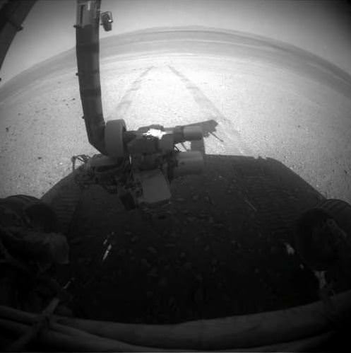
The Opportunity Mars rover looks back at the tracks left along the rim of Endeavour Crater. Credit: NASA/JPL-Caltech
Meanwhile, back in Meridiani Planum … the Opportunity rover keeps on trucking, and has now exceeded over 35 kilometers (21.75 miles) of driving on its odometer! Quite an accomplishment for the Energizer Bunny of Mars rovers, now operating for 3,057 Martian sols. As the MER team says, “Not bad for a vehicle designed for only about 1 kilometer (.6 miles) of distance and 90 sols (days) of lifetime.”
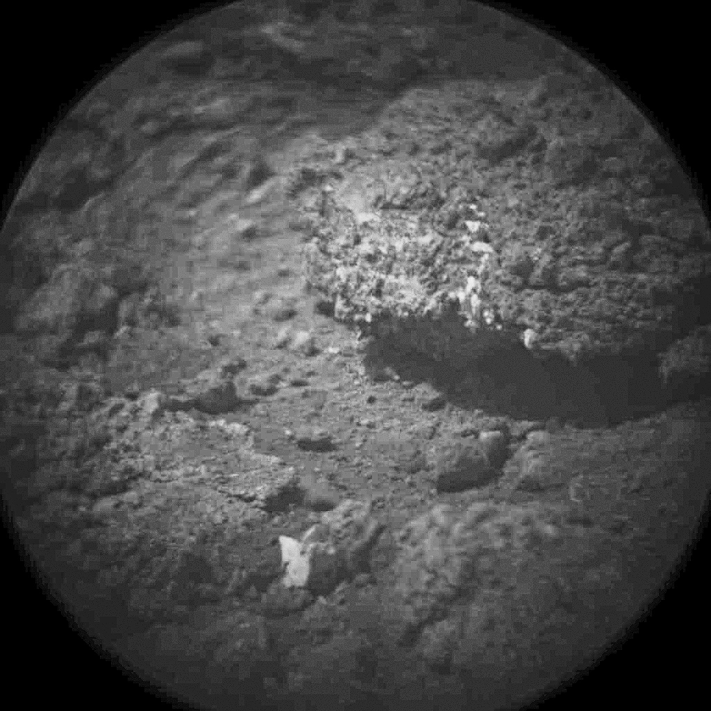
Oppy is now moving south along the inboard edge of Cape York on the rim of Endeavour Crater surveying exposed outcrop in search of phyllosilicate clay minerals that have been detected from orbit. These outcrops are quite interesting and attention-grabbing; here’s a look in color from Stuart Atkinson:
and in 3-D:
Wow!
As Stu writes in his Road to Endeavour blog, “What are those rocks made of? How did this feature form? What do the diferent colours and textures mean? These are all questions which the MER team will be hoping to answer over the next few days, I’m sure. I think we’ll see Oppy driving closer to this outcrop and studying it in a lot of detail.”
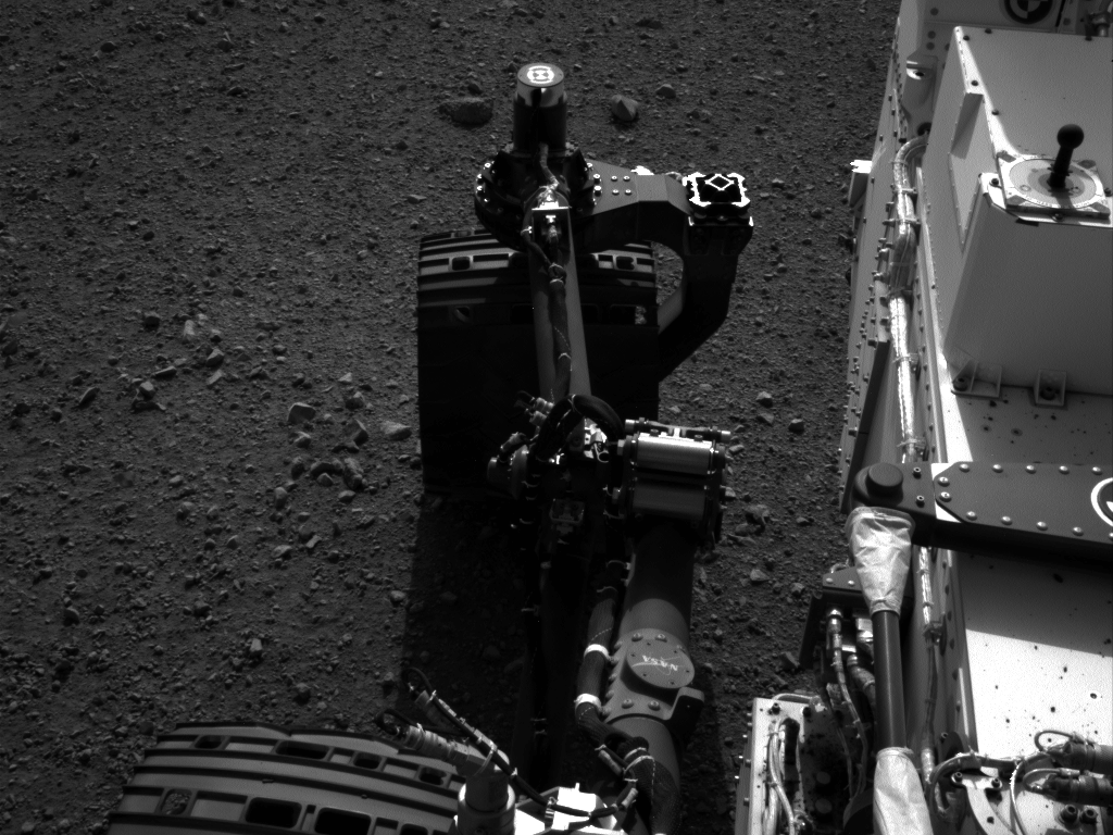
The MER team reports that on Sol 3055 (Aug. 27, 2012), the Rock Abrasion Tool (RAT) on the end of the robotic arm was imaged (top image) to re-confirm the available bit for future grinding and the Alpha Particle X-ray Spectrometer (APXS) collected a measurement of atmospheric argon.
Opportunity’s solar array energy production is good, producing about 568 watt-hours.
So, even though the Curiosity rover is grabbing the headlines, don’t forget that Opportunity is still keepin’ on, working hard on Mars.
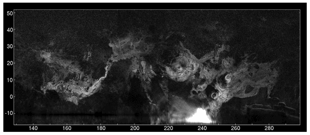
A radar map of Mars’ major volcanic regions created by the Arecibo Observatory in Puerto Rico (John Harmon et al., NAIC)
Even though we currently have several missions exploring Mars both from orbit and on the ground, there’s no reason that robots should be having all the fun; recently a team of radio astronomers aimed the enormous 305-meter dish at Puerto Rico’s Arecibo Observatory at Mars, creating radar maps of the Red Planet’s volcanic regions and capturing a surprising level of detail for Earth-based observations.
The team, led by John Harmon of the National Astronomy and Ionosphere Center, bounced radar waves off Mars from Arecibo’s incredibly-sensitive dish, targeting the volcanic Tharsis, Elysium, and Amazonis regions. Depolarized radar imagery best reveals surface textures; the rougher and less uniform a surface is, the brighter it appears to radar while smooth, flat surfaces appear dark.
What the radar maps portray are very bright — and therefore rough — areas on most of the major volcanoes, although some regions do appear dark, such as the summit of Pavonis Mons.
This likely indicates a covering by smoother, softer material, such as dust or soil. This is actually in line with previous observations of the summit of Pavonis Mons made with the HiRISE camera aboard NASA’s Mars Reconnaissance Orbiter, which showed the summit to appear curiously soft-edged and “out-of-focus”, creating a blurry optical illusion of sorts.
It’s thought that the effect is the result of the build-up of dust over millennia, carried across the planet by dust storms but remaining in place once settled because the Martian wind is just so extremely thin — especially at higher altitudes.
The team also found bright areas located away from the volcanoes, indicating rough flows elsewhere, while some smaller volcanoes appeared entirely dark — again, indicating a possible coating of smooth material like dust or solidified lava flows.
The resolution of the radar maps corresponds to the wavelength of the signals emitted from Arecibo; the 12.6 centimeter signal allows for surface resolution of Mars of about 3 km.
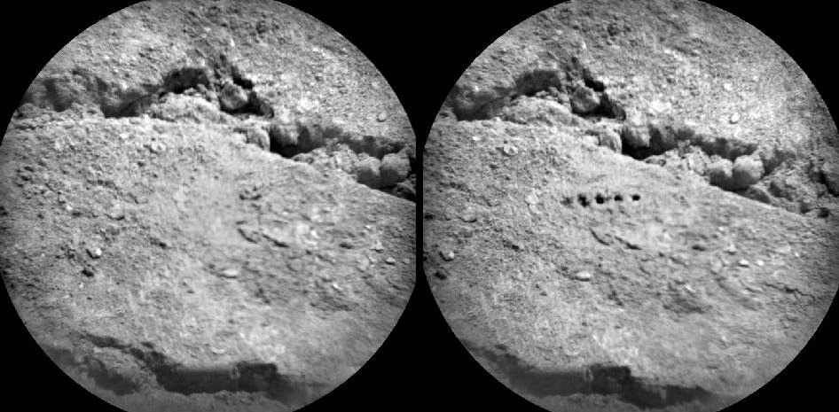
Before-and-after images from Curiosity’s ChemCam micro-imager show holes left by its million-watt laser (NASA/JPL-Caltech/LANL/CNES/IRAP/LPGN/CNRS)
PEWPEWPEWPEWPEW! Curiosity’s head-mounted ChemCam did a little target practice on August 25, blasting millimeter-sized holes in a soil sample named “Beechey” in order to acquire spectrographic data from the resulting plasma glow. The neat line of holes is called a five-by-one raster, and was made from a distance of about 11.5 feet (3.5 meters).
Sorry Obi-Wan, but Curiosity’s blaster is neither clumsy nor random!
Mounted to Curiosity’s “head”, just above its Mastcam camera “eyes”, ChemCam combines a powerful laser with a telescope and spectrometer that can analyze the light emitted by zapped materials, thereby determining with unprecedented precision what Mars is really made of.
For five billionths of a second the laser focuses a million watts of energy onto a specific point. Each of the 5 holes seen on Beechey are the result of 50 laser hits. 2 to 4 millimeters in diameter, the holes are much larger than the laser point itself, which is only .43 millimeters wide at that distance.
ChemCam’s laser allows Curiosity to zap and examine targets up to 23 feet (7 meters) away. Credit: J-L. Lacour/CEA/French Space Agency (CNES)
“ChemCam is designed to look for lighter elements such as carbon, nitrogen, and oxygen, all of which are crucial for life,” said Roger Wiens, principal investigator of the ChemCam team. “The system can provide immediate, unambiguous detection of water from frost or other sources on the surface as well as carbon – a basic building block of life as well as a possible byproduct of life. This makes the ChemCam a vital component of Curiosity’s mission.”
Visit the official ChemCam site for more information.
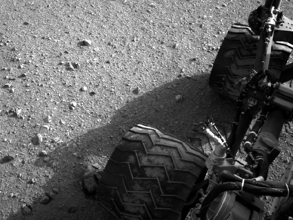
Image Caption: Martian Soil caked on Curiosity’s right middle and rear wheels after Sol 22 Drive. Credit: NASA/JPL-Caltech
Mars Trek has begun for NASA’s Curiosity rover. The mega rover has departed from her touchdown vicinity at “Bradbury Landing” and set off on a multi-week eastwards traverse to her first science target which the team has dubbed “Glenelg”
Glenelg lies about a quarter mile (400 meters) away and the car-sized rover drove about 52 feet (16 meters) on Tuesday, Aug 28 or Sol 22 of the mission.
The science team selected Glenelg as the first target for detailed investigation because it sits at the intersection of three types of geologic terrain, affording the researchers the chance to get a much more comprehensive look at the diversity of geology inside the Gale Crater landing site.
The Sol 22 drive was the third overall for Curiosity and the farthest so far. At this new location, some 33 feet ( 10 m) from Bradbury Landing , the Mastcam color camera is collecting high resolution images to create a 3 D map of features off in the distance that will aid the rover drivers in planning a safe traverse route.
“This drive really begins our journey toward the first major driving destination, Glenelg, and it’s nice to see some Martian soil on our wheels,” said mission manager Arthur Amador of NASA’s Jet Propulsion Laboratory in Pasadena, Calif. “The drive went beautifully, just as our rover planners designed it.”
In about a week, the science team plans to deploy the 7 ft (2.1 meter) long robotic arm and test the science instruments in the turret positioned at the terminus of the arm.
“We are on our way, though Glenelg is still many weeks away,” said Curiosity Project Scientist John Grotzinger of the California Institute of Technology in Pasadena. “We plan to stop for just a day at the location we just reached, but in the next week or so we will make a longer stop.”
Perhaps in about a year or so, Curiosity will reach the base of Mount Sharp, her ultimate destination, and begin climbing up the side of the 3.6 mile (5.5 km) high mound in search of hydrated minerals that will shed light on the duration of Mars watery past.
The goal is to determine if Mars ever had habitats capable of supporting microbial life in the past or present during the 2 year long primary mission phase. Curiosity is equipped with a sophisticated array of 10 state of the art science instruments far beyond any prior rover.
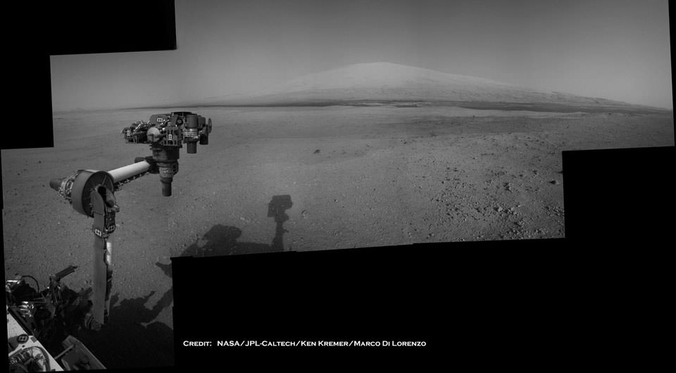
Image Caption: Curiosity Points to her ultimate drive destination – Mount Sharp – with unstowed robotic arm on Aug. 20. This navigation camera (Navcam) mosaic was assembled from images on multiple Sols. Curiosity will search for hydrated minerals using the robotic arm and a neutron detector on the body. Image stitching and processing by Ken Kremer and Marco Di Lorenzo. Featured at APOD on 27 Aug 2012. Credit: NASA/JPL-Caltech/Ken Kremer/Marco Di Lorenzo
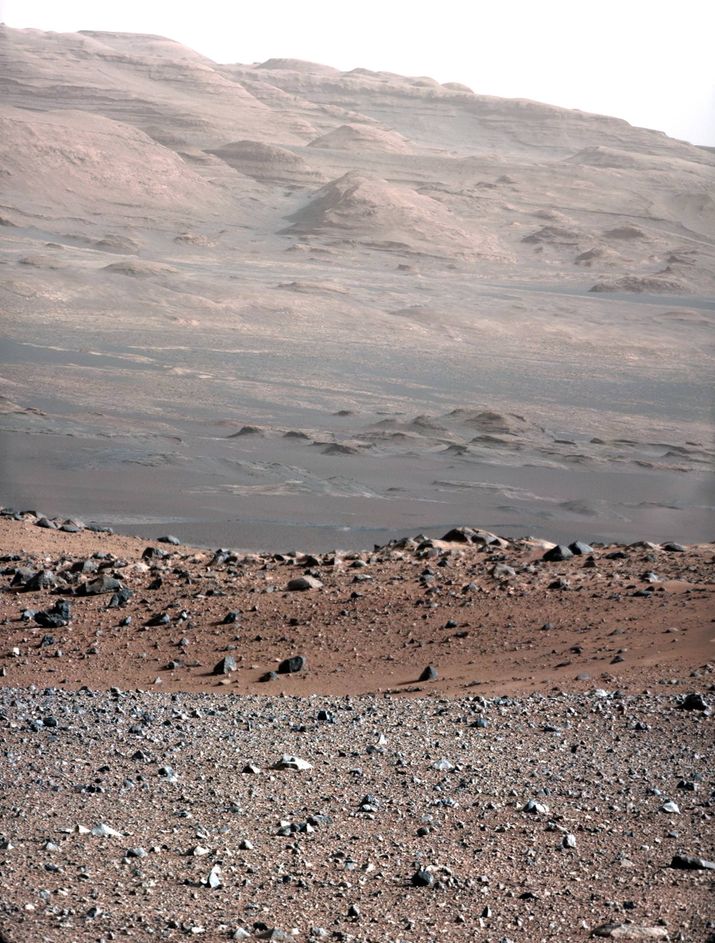
Wow — what a view! This image, released today, is a high-resolution shot of the Curiosity rover’s ultimate goal: the stratified flanks of Gale Crater’s 3.4-mile (5.5-km) high central peak, Mount Sharp. The image was taken with Curiosity’s 100mm telephoto Mastcam as a calibration test… if views like this are what we can expect from the MSL mission, all I can say is (and I’ve said it before) GO CURIOSITY!
“This is an area on Mount Sharp where Curiosity will go,” said Mastcam principal investigator Michael Malin of Malin Space Science Systems. “Those layers are our ultimate objective. The dark dune field is between us and those layers. In front of the dark sand you see redder sand, with a different composition suggested by its different color. The rocks in the foreground show diversity — some rounded, some angular, with different histories. This is a very rich geological site to look at and eventually to drive through.”
The gravel-strewn region in the foreground is Curiosity’s immediate landing area. Then the ground dips into a low depression called a swale, then rises up again to the edge of a crater that’s rimmed with larger rocks. Quite a bit beyond that (about 2.2 miles/3.7 km away) are fields of dunes composed of darker material, and then the hummocky base of Mount Sharp itself begins to rise up about 3.4 miles (5.5 km) in the distance.
The topmost ridges of Mount Sharp visible above are actually 10 miles (16.2 km) away.
A crop of the full-size image shows a large rock at the foot of a knoll that’s about the same size as Curiosity (which is this big compared to a person and previous rovers):
The rocky mound just behind the boulder in that image is itself about 1,000 feet (300 meters) across and 300 feet (100 meters) high. Gale Crater isn’t a place for a faint-hearted rover!
The colors have been modified from the original image in order to help better discern landforms and differences in surface materials. Here, the images look more like what we’d see under natural Earthly lighting.
Curiosity already is returning more data from the Martian surface than have all of NASA’s earlier rovers combined.
“We have an international network of telecommunications relay orbiters bringing data back from Curiosity,” said JPL’s Chad Edwards, chief telecommunications engineer for NASA’s Mars Exploration Program. “Curiosity is boosting its data return by using a new capability for adjusting its transmission rate.”
“The knowledge we hope to gain from our observation and analysis of Gale Crater will tell us much about the possibility of life on Mars as well as the past and future possibilities for our own planet. Curiosity will bring benefits to Earth and inspire a new generation of scientists and explorers, as it prepares the way for a human mission in the not too distant future.”
– NASA Administrator Charles Bolden in a message transmitted to the Curiosity rover and then back to Earth, August 27, 2012
Today’s Astronomy Picture of the Day (APOD) features a mosaic put together in part by Universe Today’s Ken Kremer, along with his imaging partner Marco Di Lorenzo, using images sent back from the Curiosity rover. It shows Curiosity’s landing site, Bradbury Landing, with its ultimate destination, Aeolis Mons/Mount Sharp off in the distance. It’s a beautiful and crisp image, which show parts of the rover itself — including the extended robotic arm — and its shadow on Mars. As the APOD editors Robert Nemiroff and Jerry Bonnell say, “If life ever existed on Mars it might well have been here in Gale crater, with the Curiosity rover being humanity’s current best chance to find what remains.”
Congrats to Ken and Marco for being featured on APOD!
Images from the Curiosity rover on Mars are truly spectacular but a large mosaic from the THEMIS camera aboard NASA’s Mars Odyssey orbiter gives a grand perspective of our new foothold on Mars. Take some time to rove and explore Gale Crater.
The viewer, created using a web-imaging technology from Zoomify, is set to move between points of interest, such as Mars Science Laboratory’s landing site in Aeolis Palus, Glenelg, and Aeolis Mons/Mount Sharp itself. The layered sediments flanking Mount Sharp make it the primary target for Curiosity’s two-year mission. Take control at anytime by clicking on the image. This will stop the automatic roving and leave you in control to explore the terrain of Gale Crater. Use your mouse or the toolbar controls to pan and zoom around the image. You can also use the dropdown in the upper right to take you directly to certain points of interest in the image. Over time, we will add to this interactive feature as more geological points of interest are identified.
THEMIS stands for Thermal Emission Imaging System which is a multiband visible and infrared camera aboard Odyssey. The comprehensive mosaic is pieced together from 205 individual scenes, most taken recently but some dating to 2002 shortly after Odyssey entered Mars orbit in 2001. These images were taken before MSL landed on Mars. Even so, as large as the SUV-sized rover is, it would be too small to see in these images. The smallest details in this image are 18 meters or 60 feet across.
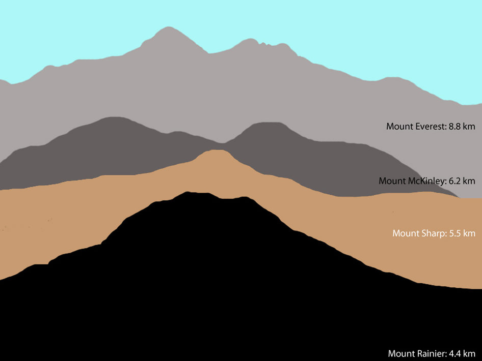
This illustration shows the size of Aoelis Mons (Mount Sharp) in comparison to three large mountains on Earth. The elevation of Mount Sharp is given in kilometers above the floor of Gale Crater. The heights of the Earth mountains are given in kilometers above sea level. Image credit: Tanya Harrison, NASA/JPL-Caltech/MSSS
Gale Crater is 154 kilometers (96 miles) wide. Near the center rises Aeolis Mons, a 5 km (3 mile) high mound of layered sediments, informally dubbed Mount Sharp, after planetary geologist Robert Sharp who died in 2004. Scientists for a time referred to the conical mountain as “The Mound.” The mountain, which would stand among the highest on Earth, cannot be seen from Earth and was unknown before planetary probes visited the Red Planet.
“The reason we decided to assemble such a large, comprehensive mosaic of Gale Crater was to give ourselves a better sense of the context around the landing site, said Jonathon Hill, a Mars research at Arizona State University who assembled the mosaic, a press release. “This will help us to better understand what Curiosity sees and measures as it roves the surface.”
Gale Crater zoom tour created by John Williams (TerraZoom) using Zoomify.
About the author:John Williams is owner of TerraZoom, a Colorado-based web development shop specializing in web mapping and online image zooms. He also writes the award-winning blog, StarryCritters, an interactive site devoted to looking at images from NASA’s Great Observatories and other sources in a different way. A former contributing editor for Final Frontier, his work has appeared in the Planetary Society Blog, Air & Space Smithsonian, Astronomy, Earth, MX Developer’s Journal, The Kansas City Star and many other newspapers and magazines.
It keeps getting better! This is a full-resolution version of the NASA Curiosity rover descent to Mars, taken by the MARDI descent imager. This video, put together by Daniel Luke Fitch, uses all but a dozen of the full resolution 1600×1200 frames (some haven’t been uploaded from the rover yet). The result is a mind-blowing, HD view of Curiosity’s view as it landed — and it also shows the best views yet of the heat shield impact. Wow!
Click to animate: this gif image shows the movement of the rear right wheel of NASA’s Curiosity as rover drivers turned the wheels in place at the landing site on Mars. Image credit:NASA/JPL-Caltech
She turned her right rear wheel in and turned her right rear wheel out in a sort of Hokey-Pokey-like action in preparation for actually moving inside Gale Crater. Yesterday, the Curiosity rover’s first movements was this “wiggle” of each of the four corner wheels for the first time. Curiosity Mission Manager Michael Watkins said this was a test of the steering actuators on the wheels, and was critical preparation for Curiosity’s first drive on Mars.
Late last night, the rover team sent commands for doing the first drive, and we’ll likely have information on whether that first drive was successful, as JPL has a news conference planned for 17:00 UTC, 1 pm EDT on Wednesday.
Below is a video animation of the rover’s first arm movements, as well:
Other news from the press conference yesterday is that all the instruments are working well on the rover so far, except for one of the instruments on the weather station.
One of the two sets of Rover Environmental Monitoring Station (REMS) wind sensors is not providing data. “One possibility is that pebbles lofted during the landing hit the delicate circuit boards on one of the two REMS booms,” said Curiosity Deputy Project Scientist Ashwin Vasavada of NASA’s Jet Propulsion Laboratory, Pasadena, Calif. “We will have to be more clever about using the remaining wind sensor to get wind speed and direction.”
The rover’s weather station, build by researchers in Spain, checks air temperature, ground temperature, air pressure, wind and other variables every hour at the landing site in Gale Crater. On a typical Martian day, or “sol,” based on measurements so far in the two-week old mission, air temperatures swing from minus 2 to minus 75 Celsius (28 degrees to minus 103 degrees Fahrenheit). Ground temperatures change even more between afternoon and pre-dawn morning, from 3 to minus 91 Celsius (37 degrees to minus 132 degrees Fahrenheit ).
“We will learn about changes from day to day and season to season,” said Javier Gómez-Elvira of the Centro de Astrobiología, Madrid, Spain, principal investigator for REMS.
The team predicts that within a week or so, daily Mars weather reports from Curiosity will become available at this website: http://cab.inta-csic.es/rems/marsweather.html or bit.ly/RzQe6p.
Another instrument provided by Russia is checking for water bound into minerals in the top one meter (three feet) of soil beneath the rover. It employs a technology that is used in oil prospecting on Earth, but had never before been sent to another planet.
“Curiosity has begun shooting neutrons into the ground,” said Igor Mitrofanov of Space Research Institute, Moscow, principal investigator for this instrument, called the Dynamic Albedo of Neutrons, or DAN. “We measure the amount of hydrogen in the soil by observing how the neutrons are scattered, and hydrogen on Mars is an indicator of water.”
The most likely hydrogen to be found in shallow ground of Gale Crater, near the Martian equator, is in hydrated minerals. These are minerals with water molecules, or related ions, bound into the crystalline structure of rocks. They can tenaciously retain water from a wetter past after all free water has gone.
With plans for Curiosity to begin roving, there will soon be new places for all the instruments to measure. The rover team explained the first real drive today will be a very simple execution: forward about 3 meters, then a turn in place of 90 degrees to the right, then a 2-meter drive backwards. Estimates are the rover will end up about 3 meters from its current position and be facing south instead of east.
This (adjusted) image was taken by ChemCam’s Remote Micro-Imager on Sol 15 (NASA/JPL-Caltech/LANL)
While Curiosity has been getting a good look around its landing spot on Mars, taking in the sights and sending back some impressive views of distant hills and Gale Crater’s enormous central peak, it’s also been peering very closely at some tiny targets just meters away — with its head-mounted, laser-powered and much-touted ChemCam.
The images above and below were acquired by ChemCam’s Remote Micro-Imager on August 21, the 15th “Sol” of the mission. A full-sized image accessed from the public MSL mission site, it’s been brightened quite a bit to show the details of the target rocks.
Mounted to Curiosity’s “head”, just above its Mastcam camera “eyes”, ChemCam combines a powerful laser with a telescope and spectrometer that can analyze the light emitted by zapped materials, thereby determining with unprecedented precision what Mars’ rocks are really made of.
So even though the rover hasn’t actually roved anywhere yet, it’s still performing valuable scientific investigations of Mars — without moving a single wheel. (UPDATE: actually, Curiosity has begun to do some roving — here are some images of its first wheel tracks!)
Because ChemCam uses a laser, Curiosity can examine many targets — up to a dozen — within a small time period without having to drive right up to them. Even the dustiest rocks won’t pose a problem for ChemCam – one or two zaps with its laser will be enough to vaporize any loose surface material.
In addition to searching for the building blocks of life hidden inside rocks, ChemCam will also serve a precautionary role for future explorers by helping identify the potential toxicity of Mars’ soil and dust. When astronauts one day land on Mars, they are going to get dusty. It’s important to know if Mars’ dust contains anything dangerous like lead, arsenic (and who knows what else!)
See the latest images from the MSL mission — including more ChemCam pictures — here.
Images: NASA/JPL-Caltech/LANL. Edited by J. Major.