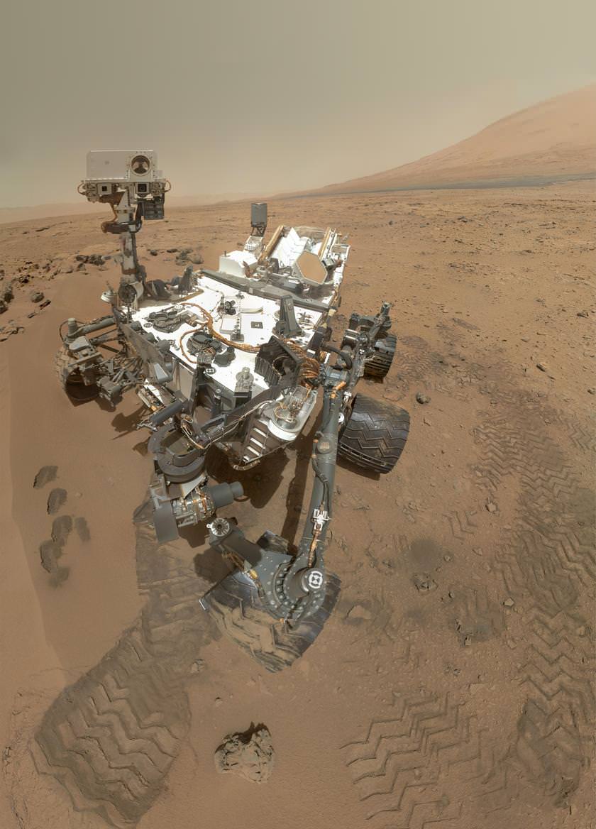
The Curiosity rover self portrait. Credit: NASA/JPL-Caltech/Malin Space Science Systems
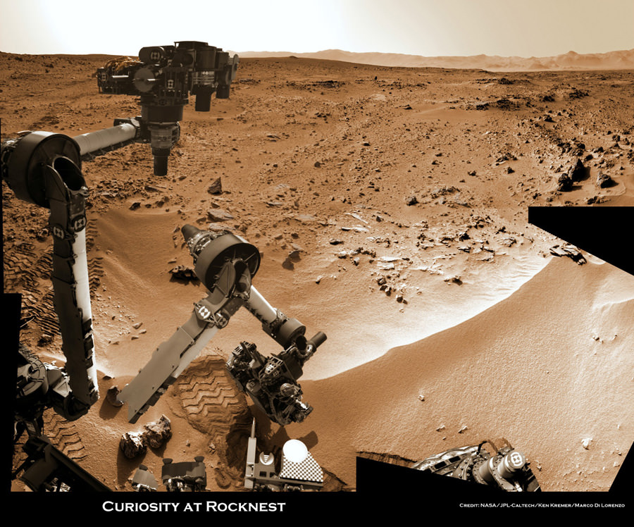
OK, we thought the low-resolution self-portrait from yesterday was great… but here’s the real goods: a monster, high-resolution awesome mosaic of 55 images taken by the Mars Hand Lens Imager (MAHLI), showing the rover at its spot in Gale Crater — called Rocknest — with the base of Gale Crater’s 5-kilometer- (3-mile-) high mountain, Aeolis Mons or Mount Sharp, rising in the background. The images were taken on Sol 84 (Oct. 31, 2012), and sent to Earth today. In the foreground, four scoop scars can be seen in the regolith in front of the rover. As we mentioned about the previous MAHLI mosaic, the arm was moved for each of the 55 images, so the arm and the camera doesn’t show up, just like any photographer behind the camera (or their arms) isn’t visible in a photograph.
You can get access to the full resolution version at this link. It’s amazing.
But that’s not all…
NASA says that self-portraits like this one document the state of the rover and allow mission engineers to track changes over time, such as dust accumulation and wheel wear. Due to its location on the end of the robotic arm, only MAHLI (among the rover’s 17 cameras) is able to image some parts of the craft, including the port-side wheels.
Emily Lakdawalla at the Planetary Blog talks about the projection issue, where the wheel closest to the front looks big and distorted. That’s a factor of the camera angle and Emily mentions a discussion of this is taking place by the image wizards over at Unmanned Spaceflight , if you want to see the various ways to deal with this issue.
Emily also points out how the rover photographed itself photographing itself — due to the reflective surfaces on the turret, so check out her analysis.
But the other cool thing is that another whole set of images was taken from a slightly different angle, which means only one thing: 3-D! Here’s Stu Atkinson’s first quick attempt:
There will surely be some refinements of the 3-D version, but enjoy this one for now!
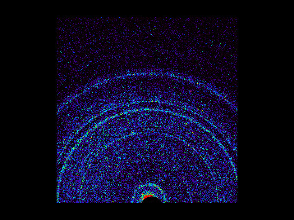
This graphic shows results of the first analysis of Martian soil by the Chemistry and Mineralogy (CheMin) experiment on NASA’s Curiosity rover. Credit: NASA/JPL-Caltech/Ames
Soil scooped up by the Curiosity rover has been analyzed by instruments on board similar to what would be used by geologists on Earth in a laboratory, and the results show the mineralogy of Martian soil is fairly Earth-like, with evidence of past interaction with water. The minerals were identified in the first sample of Martian soil put inside the Chemistry and Mineralogy instrument (CheMin), which were zapped with X-Rays to provide accurate identification of minerals.
“This Martian soil that we’ve analyzed on Mars just this past week appears mineralogically similar to some weathered basaltic materials that we see on Earth,” said David Bish, a CheMin co-investigator with Indiana University, during a press briefing on Tuesday, saying the soil appears similar to weathered basaltic soils of volcanic origin in Hawaii.
The results weren’t too surprising, the team said
Other Earth-like references have been made about Mars recently: In an op-ed article in the New York Times, MSL project scientist John Grotzinger said some of the rocks Curiosity has studied early in the mission are reminiscent of rocks Grotzinger “skipped” across a stream near his childhood home near Huntingdon Valley, Pennsylvania. And a team of researchers from Spain said the rocks where Curiosity is roving are similar to those found in Cuatro Ciénegas, a Mexican valley that may be an Earthly analog what Gale Crater was like millions of years ago.
Curiosity’s mission is to determine if Gale Crater ever offered environmental conditions favorable for microbial life, and so identifying minerals in rocks and soil is crucial to assess the history of this region. Each mineral records the conditions under which it formed.
CheMin uses X-ray diffraction, the standard practice for geologists on Earth using much larger laboratory instruments, and this is the first time this method has been used on another planet. It provides more accurate identifications of minerals than any method previously used on Mars. X-ray diffraction reads minerals’ internal structure by recording how their crystals distinctively interact with X-rays.
“Our team is elated with these first results from our instrument,” said Blake. “They heighten our anticipation for future CheMin analyses in the months and miles ahead for Curiosity.”
A MastCam image of Rocknest. Credit: NASA/JPL-Caltech/MSSS
Curiosity scooped dust and sand in the small dunes named Rocknest. The sample was processed through a sieve to exclude particles larger than 0.006 inch (150 micrometers), roughly the width of a human hair. The sample has at least two components: dust distributed globally in dust storms and fine sand originating more locally.
“Much of Mars is covered with dust, and we had an incomplete understanding of its mineralogy,” said Bish. “We now know it is mineralogically similar to basaltic material, with significant amounts of feldspar, pyroxene and olivine, which was not unexpected. Roughly half the soil is non-crystalline material, such as volcanic glass or products from weathering of the glass. ”
Bish said, “So far, the materials Curiosity has analyzed are consistent with our initial ideas of the deposits in Gale Crater recording a transition through time from a wet to dry environment. The ancient rocks, such as the conglomerates, suggest flowing water, while the minerals in the younger soil are consistent with limited interaction with water.”
These results are consistent with the previous determination by the MSL science team that ankle-to-hip-deep water once vigorously flowed in an ancient streambed in Gale Crater.
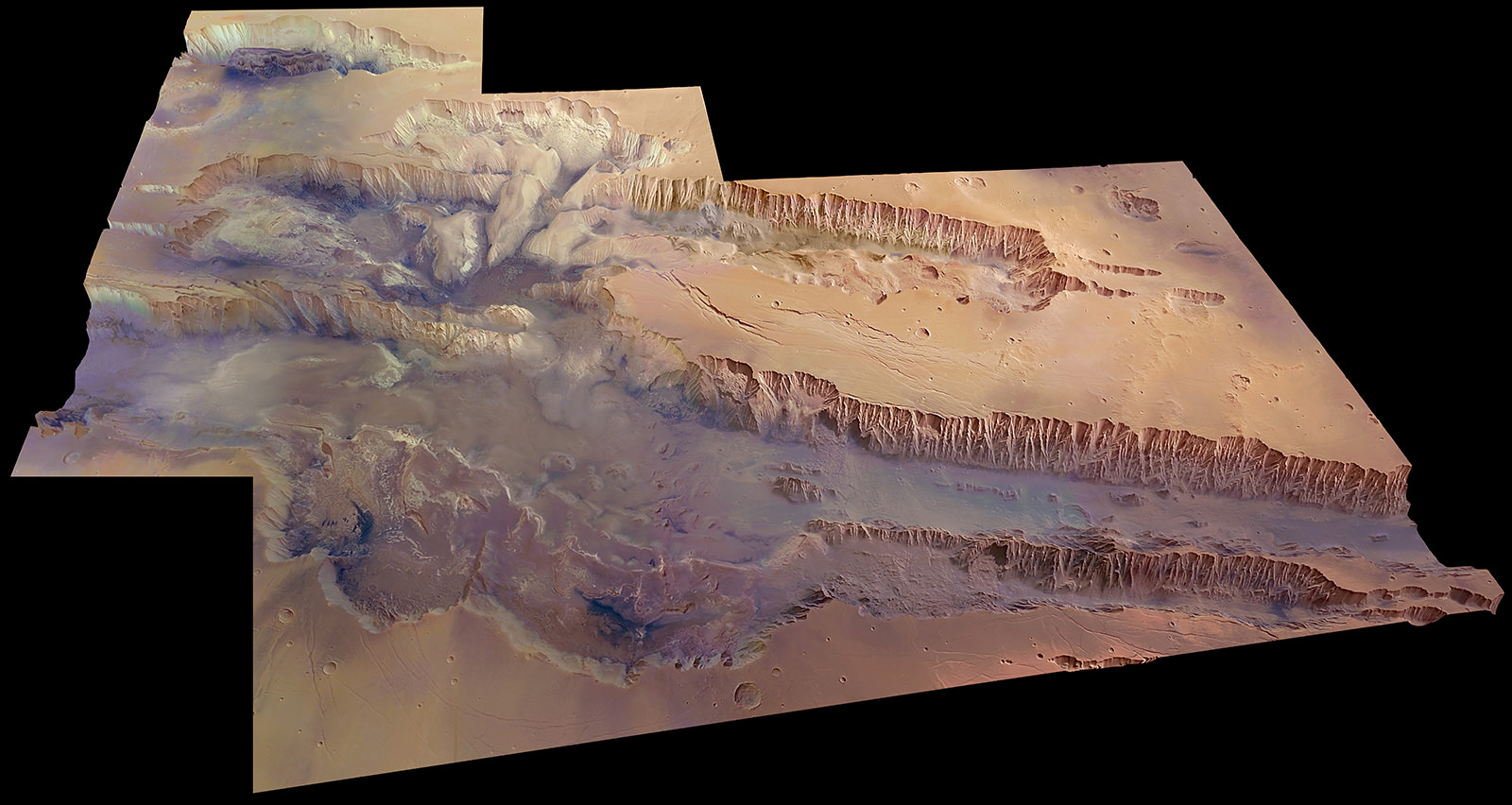
A digital terrain model of a portion of Mars’ Valles Marineris, the largest canyon in the Solar System. Credit: ESA/DLR/FU Berlin (G. Neukum)
Anyone who’s visited the Grand Canyon in Arizona can attest to its beauty, magnificence and sheer sense of awe that comes upon approaching its rim, whether for the first time or hundred-and-first. “Grand” almost seems too inferior a title for such an enormous geological feature — yet there’s a canyon much, much bigger stretching across the surface of Mars, one that could easily swallow all of our Grand Canyon within one of its side gullies.
The image above, released online for the first time today by ESA, is a digital terrain model of a portion of Mars’ Valles Marineris: our Solar System’s grandest canyon. It’s easy to fall into hyperbole when describing Valles Marineris. Named for NASA’s Mariner 9 spacecraft, which became the first spacecraft to orbit Mars on November 14, 1971, the canyon is over 4000 km long, 200 km wide, and 10 km deep (2,480 x 125 x 6 miles) — that’s five times deeper than the Grand Canyon and long enough to stretch across the entire contiguous United States! It’s a rift unparalleled on any other world in the Solar System.
Valles Marineris is thought to be the result of the formation of the nearby Tharsis volcanic region, home to Olympus Mons, the Solar System’s largest volcano. As the region swelled with magma billions of years ago the planet’s crust stretched and split, collapsing into a vast, deep canyon.
Much later, landslides and flowing water would help erode the canyon’s steep walls and carve out meandering side channels.
The 45-degree view above was was made from data acquired during 20 individual orbits of ESA’s Mars Express. It is presented in near-true color with four times vertical exaggeration (to increase relief contrast.) Download a high-res JPEG version here.
The largest portion of the canyon seen crossing left to right is known as Melas Chasma. Candor Chasma is the connecting trough to the north, and Hebes Chasma is in the far top left.
Below is a video released by JPL in 2006 showing a virtual fly-through of Valles Marineris, shown as if you were on a Grand Canyon-style helicopter sightseeing tour (that is, if helicopters could even work in the thin Martian air!)
Hopefully someday we’ll be seeing actual videos taken above Valles Marineris and photos captured from its rim… perhaps even by human explorers! (Please exit through the gift shop.)
Image source: ESA. Video by Eric M. De Jong and Phil Christiansen et. al, Arizona State University.
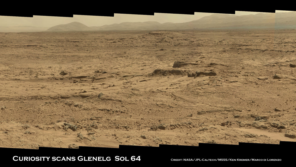
Image Caption: Panoramic mosaic shows gorgeous Glenelg snapped by Curiosity on Sol 64 (Oct. 10) with eroded crater rim and base of Mount Sharp in the distance. This is a cropped version of the full mosaic as assembled from 75 images acquired by the Mastcam 100 camera. See full mosaic below. Credit: NASA/JPL-Caltech/MSSS/Ken Kremer/Marco Di Lorenzo
NASA’s 1 ton mega rover Curiosity is simultaneously eating Martian dirt and busily snapping hundreds of critical high resolution color photos of her surroundings at the gorgeous locale of tasty terrain of outcrops the scientists call the ‘Promised Land’ – a place that will help unveil the watery mysteries of ancient Mars.
11 weeks into Curiosity’s 2 year primary mission she finds herself at a spot dubbed Glenelg – her first major science destination – and which lies at the natural junction of three types of geologically varied terrain.
See our detailed color panoramic mosaics of the road ahead inside Glenelg as the robot methodically scans around at the inviting mix of geologic features never before investigated by a robotic emissary from Earth.
Glenelg offers an unprecedented opportunity for a boon of discoveries to the rover science team long before she arrives at her ultimate destination – the 3.4 mile (5.5 km) high layered mountain named Mount Sharp.
Image Caption: Panoramic mosaic shows gorgeous Glenelg snapped by Curiosity from Rocknest windblown dune on Sol 64 (Oct. 10) with eroded crater rim and base of Mount Sharp in the distance. This mosaic as assembled from 75 images acquired by the high resolution Mastcam 100 camera on Sol 64. Click to enlarge. Credit: NASA/JPL-Caltech/MSSS/Ken Kremer/Marco Di Lorenzo
Image Caption: Panorama shows beautiful vista of distant eroded rim of Gale Crater and breathtaking foreground terrain. This mosaic was assembled from high resolution Mastcam 100 images taken by Curiosity on Sol 50 (Sep. 26). Credit: NASA/JPL-Caltech/MSSS/Ken Kremer/Marco Di Lorenzo
Curiosity Project Scientist John Grotzinger scientist explained to me that the team is using the Mastcam 100 imagery to come up with options for the upcoming driving and exploration plan to be carried out over at least the next few weeks.
“We are at Glenelg and consider ourselves to be in the ‘Promised Land’. We took the images in the direction we will be traveling,” said Curiosity Project Scientist John Grotzinger of the California Institute of Technology during a media teleconference on Oct. 18.
“We mostly see outcrops there and that’s the reason we took those prioritized images,” he said about the Mastcam 100 imagery from Sols 64 and 66.
“These images will help guide us and give the team options in terms of what I am calling ‘tours’. The team comes up with hypothesis based on the images about observations they would like to make and where they would like to drive.”.
“Then we will integrate the different observations to come up with a model we hope for how the Glenelg area was put together geologically. And then that will inform ultimately our selection for which rock to drill into for the first time,” explained Grotzinger.
Image Caption: Curiosity scoops up Martian soil sample on Sol 66 (Oct 12. 2012). Navcam camera image mosaic shows the robotic arm at work during scooping operations. Curiosity later delivered the first soil sample to the circular CheMin sample inlet at the center on the rover deck. Tiny trenches measure about 1.8 inches (4.5 centimeters) wide. Credit: NASA/JPL-Caltech/Ken Kremer/Marco Di Lorenzo
Image caption: Three bite marks left in the Martian ground by the scoop on the robotic arm of NASA’s Mars rover Curiosity are visible in this image taken by the rover’s right Navigation Camera during the mission’s 69th Martian day, or sol (Oct. 15, 2012). Credit: NASA/JPL-Caltech
Curiosity is currently parked at a windblown ripple named ‘Rocknest’. It afforded the perfect type of dusty martian material to first test out the scoop and clean the sample processing system twice before finally inhaling the first sample of Martian sand into the robots Chemistry and Mineralogy (CheMin) analytical instrument several sols ago to determine what minerals it contains.
Results from the Red Planet soil poured into the CheMin experiment located on the rover’s deck are expected in the coming week or so.
Tosol is Sol 75. Curiosity has taken nearly 20,000 pictures so far and driven a total distance of about 1,590 feet (484 meters).
See more of our Curiosity Mars mosaics by Ken Kremer & Marco Di Lorenzo at NBC News Cosmic log
…..
Nov. 16: Free Public Lecture by Ken Kremer about “Curiosity and the Search for Life in 3 D” and more at Union County College and Amateur Astronomers Inc in Cranford, NJ.
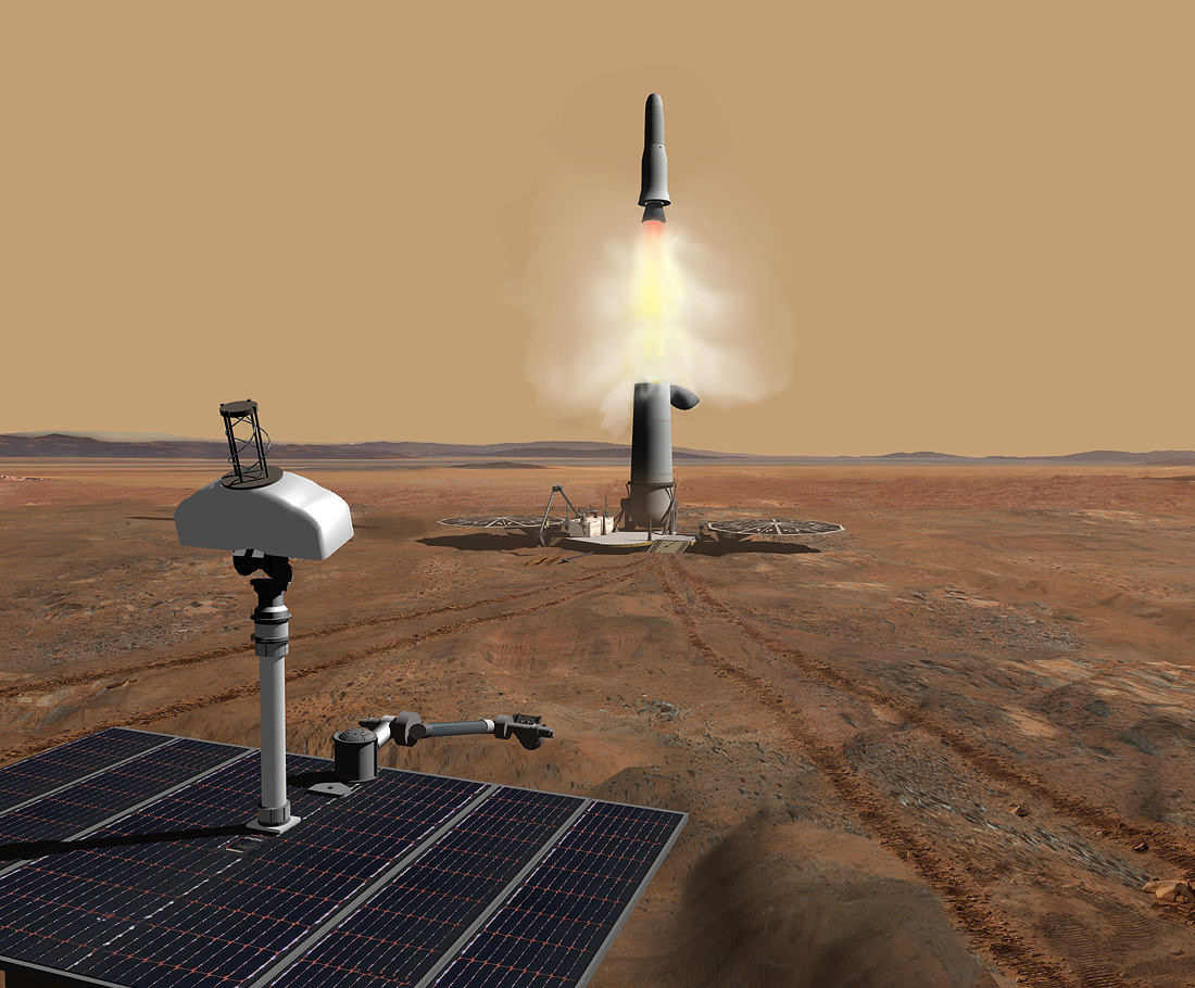
Artist concept of a Mars Sample Return mission. Credit: Wickman Spacecraft & Propulsion.
A Mars sample return mission has long been a dream and goal of many planetary scientists. Getting Martian soil samples back here on Earth would allow them to be studied in ways rovers and landers just can’t do. Of course, the big reason for getting samples of Mars back to Earth would be to really determine if there ever was – or is — life on Mars. But a sample return mission would be “hellishly difficult,” Steve Squyres of the MER mission once said.
But forget sending a lander, scooping up samples, putting them in a capsule and somehow rocketing them back to Earth. Human genome sequencer Craig Venter wants to send a DNA sequencing machine Mars, and beam back the DNA data to Earth. Not to be outdone, Jonathan Rothberg, founder the DNA sequencing company Ion Torrent, is working on getting his Personal Genome Machine to Mars and sending back the data.
In articles in the Los Angeles Times and MIT’s Technology Review this week the two biologists seem to be in a race, of sorts, to see who could send their DNA machines to Mars first. Venter was quoted as saying, “There will be life forms there,” Venter said, and wants to build a “biological teleporter.”
Rothberg is looking to be part of a NASA-funded project at Harvard and MIT called SET-G, or “the search for extraterrestrial genomes.”
An MIT researcher involved in the project, Christopher Carr, told Technology Review that his lab is working to shrink Ion Torrent’s machine from 30 kilograms down to just three kilograms so that it can fit on a NASA rover, and they are testing how well the device can withstand the heavy radiation it would encounter on the way to Mars.
With NASA’s current budget woes, a sample return mission likely couldn’t happen until around 2030. But another Mars rover mission may be slated for 2018, if all goes well, and a DNA sequencer could potentially be part of the mission, the two biologists said. And an in-situ DNA sequencer avoids the potential pitfalls of a sample return mission.
“People are worried about the Andromeda strain,” Venter said. “We can rebuild the Martians in a P-4 spacesuit lab instead of having them land in the ocean.”
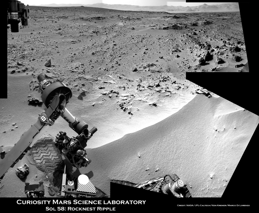
Image caption: Time lapse context view of Curiosity maneuvering her robotic arm. Curiosity conducts a close- up examination of windblown ‘Rocknest’ ripple site and inspects sandy material at “bootlike” wheel scuff mark with the APXS (Alpha Particle X-Ray Spectrometer) and MAHLI (Mars Hand Lens Imager) instruments positioned on the rotatable turret at the arm’s terminus. Colorized mosaic was stitched together from Sol 57 & 58 Navcam raw images shows the arm in action just prior to 1st sample scooping here. Surrounding terrain and eroded rim of Gale Crater rim is visible on the horizon. Credit: NASA/JPL-Caltech/Ken Kremer/Marco Di Lorenzo
NASA’s Curiosity rover is actively searching for uncontaminated Martian soil after finding new flecks of “bright material” of unknown origin in the windblown sands at “Rocknest” ripple.
The team leading the Curiosity Mars Science Lab (MSL) mission decided to dump the second scoopful of dusty material collected last week on Sol 66 (Oct. 12). Instead they will search for pristine Martian sand to pour into the rover’s critical sample-processing mechanisms to use as a decontamination agent for cleansing the interior chambers and walls of Earthly residues.
Image Caption: Bright Particle of Martian Origin in Scoop Hole. This image contributed to an interpretation by NASA’s Mars rover Curiosity science team that some of the bright particles on the ground near the rover are native Martian material. Other light-toned material nearbyhas been assessed as small debris from the spacecraft. Curiosity’s Mars Hand Lens Imager (MAHLI) camera took this image on Sol 66 (Oct. 12, 2012) showing part of the hole or bite left in the ground when Curiosity collected its first scoop of Martian soil five sols earlier. A clod of soil near the top center of the image contains a light-toned particle. The observation that the particle is embedded in the clod led scientists to assess this particle as Martian material, not something from the spacecraft. This assessment prompted the mission to continue scooping in the area, despite observations of a few light-toned particles in the area being scooped. The image shows an area about 2 inches (5 centimeters) across. It is brightened to improve visibility in the shaded area. Credit: NASA/JPL-Caltech/MSSS
The science team is proceeding with appropriate caution – just as they indicated at press briefings – so as not to gum up the sample processing system with material that could give false positive readings for organic compounds or compromise the integrity of the rover’s delicate sample handling and delivery system.
“Concerns that the bright spot is more material shed from the flight system, and that some of this terrestrial material is in the scooped dirt, led the tactical team to decide to dump the scoop and take MAHLI images of the scoop targets first,” wrote MSL scientist Ken Herkenhoff in a rover team update.
The second scoopful of Martian sand from Rocknest was intentionally discarded on Sol 67 (Oct.13) after up close imaging by the MAHLI microscopic imaging camera revealed several specks of bright material that could be debris from the landing system or the rover itself or possibly even native Martian material.
The third test sample will be carefully analyzed by MAHLI, ChemCam and Mastcam and verified to be free of FOD before the team decides to pour the new processed sand into the processing system and eventually into the Sample Analysis at Mars (SAM) and Chemistry and Mineralogy (CheMin) analytical chemistry instruments on the rover deck.
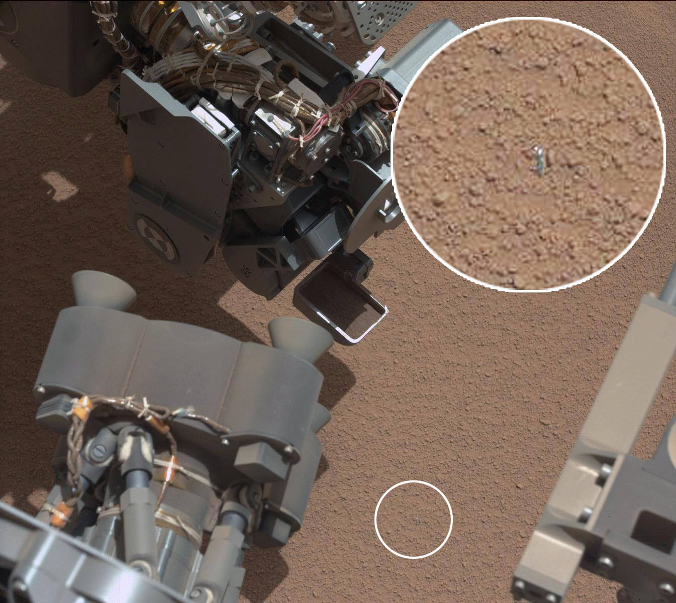
Image Caption: Small Debris on the Ground Beside Curiosity – This image from the Mars Hand Lens Imager (MAHLI) camera on NASA’s Mars rover Curiosity shows a small bright object on the ground beside the rover at the “Rocknest” site about half an inch (1.3 centimeters) long. The rover team has assessed this object as debris from the spacecraft, possibly from the events of landing on Mars. The image was taken on Sol 65 (Oct. 11, 2012). Credit: NASA/JPL-Caltech/MSSS
Progress has been slowed somewhat by communications glitches with a radio transmitter at a Deep Space Network ground station and an unrelated new problem with NASA’s Mars Reconnaissance Orbiter (MRO) which went into “safe mode” on Sol 69. MRO serves as the highest volume communications relay for Curiosity’s images and scientific and engineering data.
Tosol is Sol 71 and Curiosity is now 10 weeks into her two year long mission to investigate whether Mars ever had conditions sufficient to sustain microbial life forms.
Curiosity made a pinpoint landing inside Gale Crater on Aug. 5/6, just a few miles away from her ultimate destination – the sedimentary lower layers of Mount Sharp holding deposits of hydrated minerals.
Video Caption: This 256 frame video clip shows the 1st sample of Martian material being vibrated inside Curiosity’s table spoon sized scoop on Oct. 7, 2012.
While scooping its first samples of Martian soil, NASA’s Curiosity rover captured the image above, which shows what seems to be a small, seemingly metallic sliver or chip of… something… resting on the ground. Is it a piece of the rover? Or some other discarded fleck of the MSL descent mechanisms? Or perhaps an exotic Martian pebble of some sort? Nobody knows for sure yet, but needless to say the soil samples have taken a back seat to this new finding for the time being.
ChemCam shot of a recently spotted unknown object on Mars. (NASA/JPL-Caltech)
The ChemCam image, although monochrome, reveals some interesting and curiously organic-looking edges on the object… although it could be a bit of something that came loose from the rover itself. Perhaps a bit of plastic wrap or tape from a cable? Or a flake of metal from the back shell?
Or, as MSNBC’s Alan Boyle jokingly (?) suggested, another piece of “Martian macaroni”?
Curiosity’s first scooping activity appeared to go well on Oct. 7. Subsequently, the rover team decided to refrain from using the rover’s robotic arm on Oct. 8 due to the detection of a bright object on the ground that might be a piece from the rover. Instead of arm activities during the 62nd Martian day, or sol, of the mission, Curiosity is acquiring additional imaging of the object to aid the team in identifying the object and assessing possible impact, if any, to sampling activities.
Stay tuned for more info on this intriguing news as it’s available!
Image: NASA/JPL-Caltech
P.S. Of course, the now-famous “Sarcastic Rover” had something to say about it on Twitter:
Image caption: Context view of Curiosity working at ‘Rocknest’ Ripple. Curiosity’s maneuvers robotic arm for close- up examination of ‘Rocknest’ ripple site and inspects sandy material at “bootlike” wheel scuff mark with the APXS (Alpha Particle X-Ray Spectrometer) and MAHLI (Mars Hand Lens Imager) instruments positioned on the rotatable turret at the arm’s terminus. Mosaic was stitched together from Sol 57 & 58 Navcam raw images and shows the arm extended to fine grained sand ripple in context with the surrounding terrain and eroded rim of Gale Crater rim on the horizon. Rocknest patch measures about 8 feet by 16 feet (2.5 meters by 5 meters).See NASA JPL test scooping video below. Credit: NASA/JPL-Caltech/Ken Kremer/Marco Di Lorenzo
NASA’s Curiosity rover is set to scoop up her 1st sample of Martian soil this weekend at a soil patch nicknamed ‘Rocknest’ -see our context mosaic above – and will funtion as a sort of circulatory system cleanser for all the critical samples to follow. This marks a major milestone on the path to delivering Mars material to the sample acquisition and processing system for high powered analysis by the robots chemistry labs and looking for the ingredients of life, said the science and engineering team leading the mission at a media briefing on Thursday, Oct 4.
Since landing on the Red Planet two months ago on Aug. 5/6, Curiosity has trekked over 500 yards eastwards across Gale crater towards an intriguing area named “Glenelg” where three different types of geologic terrain intersect.
This week on Oct. 2 (Sol 56), the rover finally found a wind driven patch of dunes at ‘Rocknest’ with exactly the type of fine grained sand that the team was looking for and that’s best suited as the first soil to scoop and injest into the sample acquisition system.
See NASA JPL earthly test scooping video below to visualize how it works:
“We now have reached an important phase that will get the first solid samples into the analytical instruments in about two weeks,” said Mission Manager Michael Watkins of NASA’s Jet Propulsion Laboratory in Pasadena, Calif.
The rover used its wheels to purposely scuff the sand and expose fresh soil – and it sure looked like the first human “bootprint” left on the Moon by Apollo 11 astronauts Neil Armstrong and Buzz Aldrin.
Curiosity will remain at the “Rocknest” location for the next two to three weeks as the team fully tests and cleans the walls of most of the sample collection, handling and analysis hardware – except for the drilling equipment – specifically to remove residual contaminants from Earth.
Image caption: ‘Rocknest’ From Sol 52 Location on Sept. 28, 2012, four sols before the rover arrived at Rocknest. The Rocknest patch is about 8 feet by 16 feet (1.5 meters by 5 meters). Credit: NASA/JPL-Caltech/MSSS
The purpose of this initial scoop is to use the sandy material to thoroughly clean out, rinse and scrub all the plumbing pipes, chambers, labyrinths and interfaces housed inside the complex CHIMRA sampling system and the SAM and CheMin chemistry labs of an accumulation of a very thin and fine oily layer that could cause spurious, interfering readings when the truly important samples of Martian soil and rocks are collected for analysis starting in the near future.
The scientists especially do not want any false signals of organic compounds or other inorganic materials and minerals stemming from Earthly contamination while the rover and its instruments were assembled together and processed for launch.
“Even though we make this hardware super squeaky clean when it’s delivered and assembled at the Jet Propulsion Laboratory, by virtue of its just being on Earth you get a kind of residual oily film that is impossible to avoid,” said Daniel Limonadi of JPL, lead systems engineer for Curiosity’s surface sampling and science system. “And the Sample Analysis at Mars instrument is so sensitive we really have to scrub away this layer of oils that accumulates on Earth.”
The team plans to conduct three scoop and rinse trials – dubbed rinse and discard – of the sample acquisition systems. So it won’t be until the 3rd and 4th soil scooping at Rocknest that a Martian sample would actually be delivered for entry into the SAM and CheMin analytical chemistry instruments located on the rover deck.
“What we’re doing at the site is we take the sand sample, this fine-grained material and we effectively use it to rinse our mouth three times and then kind of spit out,” Limonadi said. “We will take a scoop, we will vibrate that sand on all the different surfaces inside CHIMRA to effectively sand-blast those surfaces, then we dump that material out and we rinse and repeat three times to finish cleaning everything out. Our Earth-based testing has found that to be super effective at cleaning.”
Limondi said the first scooping is likely to be run this Saturday (Oct 6) on Sol 61, if things proceed as planned. Scoop samples will be vibrated at 8 G’s to break them down to a very fine particle size that can be easily passed through a 150 micron sieve before entering the analytical instruments.
The team is being cautious, allowing plenty of margin time and will not proceed forward with undue haste.
“We’re being deliberately slow and incredibly careful,” said Watkins. “We’re taking a lot of extra steps here to make sure we understand exactly what’s going on, that we won’t have to do every time we do a scoop in the future.”
Curiosity’s motorized, clamshell-shaped scoop measures 1.8 inches (4.5 centimeters) wide, 2.8 inches (7 centimeters) long, and can sample to a depth of about 1.4 inches (3.5 centimeters). It is part of the CHIMRA collection and handling device located on the tool turret at the end of the rover’s arm.
“The scoop is about the size of an oversized table spoon,” said Limonadi.
Image caption: Curiosity extends 7 foot long arm to investigate ‘Bathurst Inlet’ rock outcrop with the MAHLI camera and APXS chemical element spectrometer in this mosaic of Navcam images assembled from Sols 53 & 54 (Sept. 29 & 30, 2012). Mount Sharp, the rover’s eventual destination is visible on the horizon. Thereafter the rover drove more than 77 feet (23 meters) eastwards to reach the ‘Rocknest’ sand ripple. Credit: NASA/JPL-Caltech/Ken Kremer/Marco Di Lorenzo
During the lengthy stay at Rocknest, the rover will conduct extensive investigations of the surrounding rocks and terrain with the cameras, ChemCam laser, DAN, RAD as well as weather monitoring with the REMS instrument.
After finishing her work at Rocknest, Curiosity will resume driving eastward to Glenelg, some 100 meters (yards) away where the team will select the first targets and rock outcrops to drill, sample and analyze.
At Glenelg and elsewhere, researchers hope to find more evidence for the ancient Martian stream bed they discovered at rock outcrops at three different locations that Curiosity has already visited.
Curiosity is searching for organic molecules and evidence of potential habitable environments to determine whether Mars could have supported Martian microbial life forms, past or present.
It was a slow week on Space news except for the massive announcement that an ancient riverbed was discovered on the surface of Mars. We took a look at this as well as the historic 55th anniversary of Sputnik, a precise measurement of the expansion of the Universe, and more!
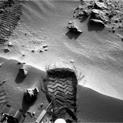
Looking very similar to the iconic first footprint on the Moon from the Apollo 11 landing, this new raw image from the Curiosity rover on Mars shows one of the first “scuff” marks from the rover’s wheels on a small sandy ridge. This image was taken today by Curiosity’s right Navcam on Sol 57 (2012-10-03 19:08:27 UTC). Rover driver Matt Heverly described a scuff as spinning one wheel to move the soil below it out of the way.
Besides being on different worlds, the two prints likely have a very different future. NASA says the first footprints on the Moon will be there for a million years, since there is no wind to blow them away. Research on the tracks left by Spirit and Opportunity revealed the time scale for track erasure by wind is typically only one Martian year or two Earth years.
Here’s one of Buzz Aldrin’s bootprint, to compare:
The GRIN website (Great Images in NASA) says this is an image of Buzz Aldrin’s bootprint from the Apollo 11 mission. Neil Armstrong and Buzz Aldrin walked on the Moon on July 20, 1969. Credit: NASA
Curiosity chief scientist John Grotzinger compared earlier images of some of the first tracks left on Mars by Curiosity to images of the footprints left by Aldrin and Armstrong on the Moon. “I think instead of a human, it’s a robot pretty much doing the same thing,” he said.