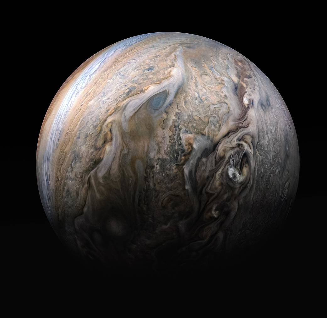
This stunning image comes from the Juno spacecraft. Citizen scientist Kevin M. Gill created it using images from Juno's JunoCam imager. Image Credit: NASA/JPL-Caltech/SwRI/MSSS/Kevin M. Gill
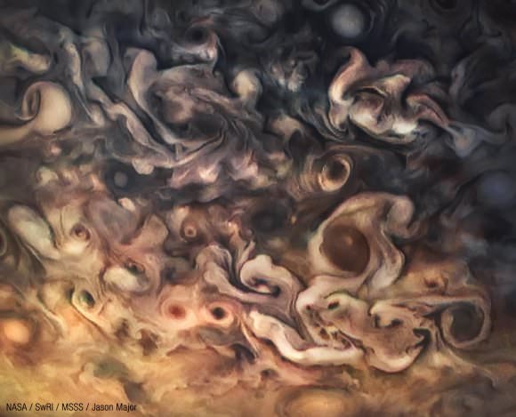
There’s something about Jupiter that mesmerizes those who gaze at it. It’s intricate, dazzling clouds are a visual representation of the laws of nature that’s hard to turn away from. And even though the Juno spacecraft has been at Jupiter for almost three years now, and has delivered thousands of images of the gas giant’s colourful, churning clouds, we can’t seem to satisfy our appetite.
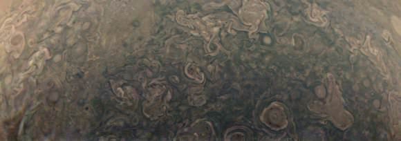
Jupiter as seen by the Juno spacecraft during the Perijove 5 pass on March 27, 2017. Processed using raw data. Credit: NASA/JPL-Caltech/SwRI/MSSS/Kevin M. Gill.
The original plans for the Juno mission to Jupiter didn’t include a color camera. You don’t need color images when the mission’s main goals are to map Jupiter’s magnetic and gravity fields, determine the planet’s internal composition, and explore the magnetosphere.
But a camera was added to the manifest, and the incredible images from the JunoCam have been grabbing the spotlight.
As an instrument where students and the public can choose the targets, JunoCam is a “public outreach” camera, meant to educate and captivate everyday people.
“The whole endeavor of JunoCam was to get the public to participate in a meaningful way,” said Candy Hansen, Juno co-investigator at the Planetary Science Institute in Tucson, Arizona, speaking at a press conference last week to showcase Juno’s science and images.
And participate they have. Hundreds of ‘amateur’ image processing enthusiasts have been processing raw data from the JunoCam, turning them into stunning images, many reminiscent of a swirling Van Gogh ‘starry night’ or a cloudscape by Monet.
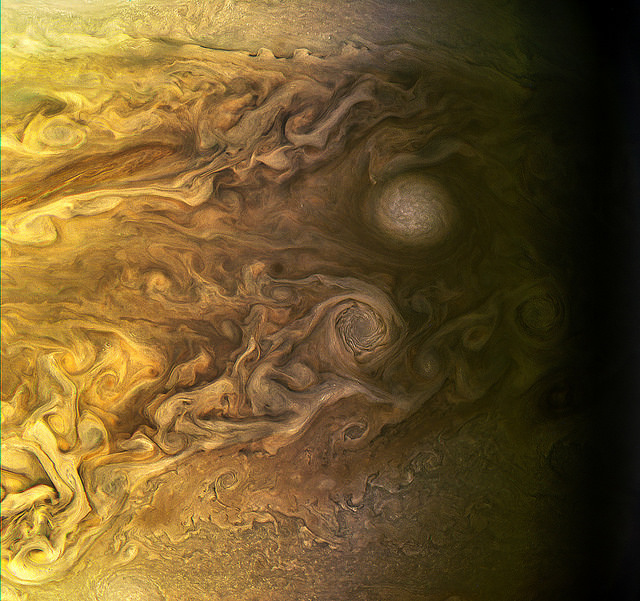
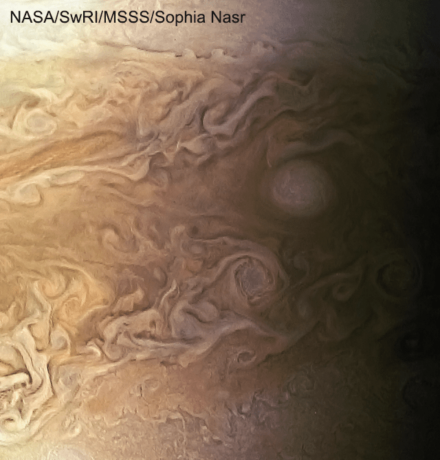
The swirling cloudtops of Jupiter, as seen by Juno during Perijove 5 on March 27, 2017. Credit: NASA/JPL-Caltech/SwRI/MSSS/Sophia Nasr.
“The contributions of the amateurs are essential,” Hansen said. “I cannot overstate how important the contributions are. We don’t have a way to plan our data without the contributions of the amateur astronomers. We don’t have a big image processing team, so we are completely relying on the help of our citizen scientists.”
Jupiter as seen by Juno during Perijove 6 in May, 2017. Credit: NASA/SwRI/MSSS/Gerald Eichstädt / Seán Doran.
Click on this image to have access to a 125 Megapixel upscaled print portrait.
Featured here are images processed by Seán Doran, Sophia Nasr, Kevin Gill and Jason Major. Like hundreds of others around the world, they anxiously await for data to arrive to Earth, where it is uploaded to the public Juno website. Then they set to work to turn the data into images.
“What I find the most phenomenal of all is that this takes real work,” Hansen said. “When you download a JunoCam image and process it, it’s not something you do in five minutes. The pictures that we get that people upload back onto our site, they’ve invested hours and hours of their own time, and then generously returned that to us.”
This video shows Juno’s trajectory from Perijove 6, and is based on work by Gerald Eichstädt, compiled and edited by Seán Doran. “This is real imagery projected along orbit trajectory,” Doran explained on Twitter.
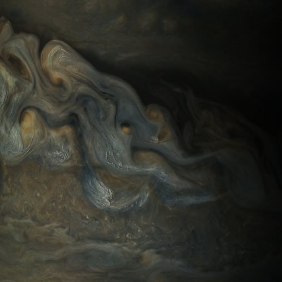
Intricate swirls on Jupiter Jupiter, from Juno’s Perijove 6 pass on May 19, 2017. Credit: NASA/JPL-Caltech/SwRI /MSSS/Kevin M. Gill.
Details of Jupiter’s swirling gas clouds, as seen by Juno during the Perijove 6 pass in May, 2017. Credit: NASA / SwRI / MSSS / Gerald Eichstädt / Seán Doran.
JunoCam was built by Malin Space Science Systems, which has cameras on previous missions like the Curiosity Mars Rover, the Mars Global Surveyor and the Mars Color Imager on the Mars Reconnaissance Orbiter. To withstand the harsh radiation environment at Jupiter, the camera required special protection and a reinforced lens.
Whenever new images arrive, many of us feel exactly like editing enthusiast Björn Jónsson:
I never expected I'd ever say this but: The latest @NASAJuno images of Jupiter are the most spectacular images of Jupiter I've ever seen. pic.twitter.com/7HawZ9RSwe
Even the science team has expressed their amazement at these images.
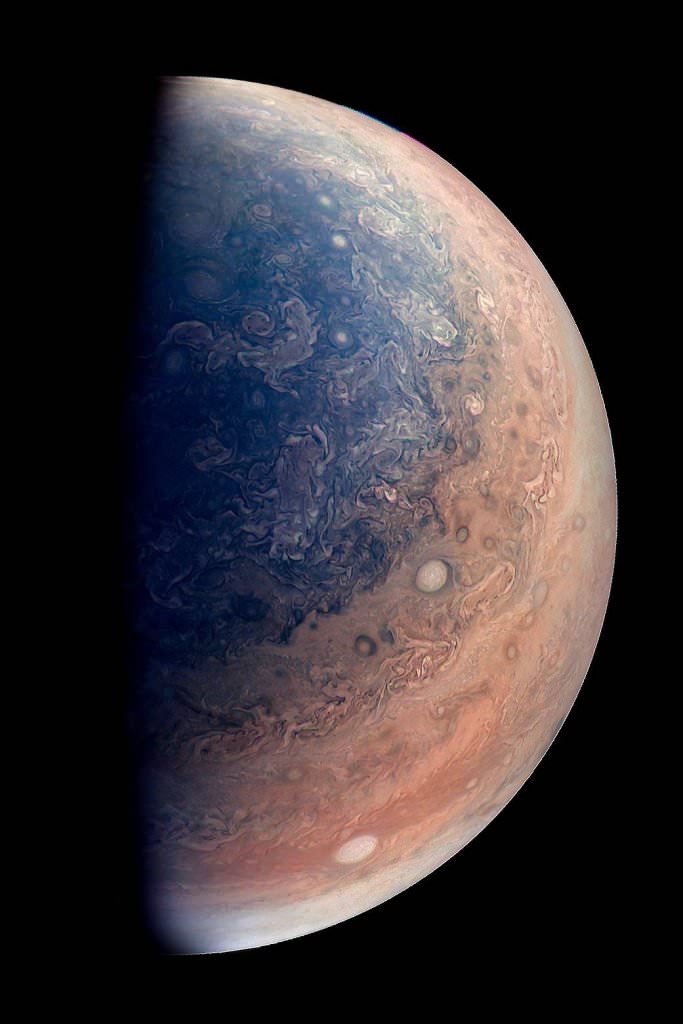
“Jupiter looks different than what we expected,” said Scott Bolton, Juno’s principal investigator at the Southwest Research Institute. “Jupiter from the poles doesn’t look anything like it does from the equator. And the fact the north and south pole don’t look like each other, makes us wonder if the storms are stable, if they going to stay that way for years and years like the the Great Red Spot. Only time will tell us what is true.”
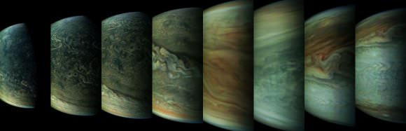
A sequence of images of Jupiter from Juno’s Perijove 6 pass during May, 2017. Credit: NASA / SwRI / MSSS / Gerald Eichstädt / Seán Doran.
Part of what makes these images so stunning is that Juno is closer to Jupiter than any previous spacecraft.
“Juno has an elliptical orbit that brings it between the inner edges of Jupiter’s radiation belt and the planet, passing only 5,000 km above the cloud tops,” Juno Project Manager Rick Nybakken told me in my book ‘Incredible Stories From Space: A Behind-the-Scenes Look at the Missions Changing Our View of the Cosmos.’ “This close proximity to Jupiter is unprecedented, as no other mission has conducted their science mission this close to the planet. We’re right on top of Jupiter, so to speak.”
Juno engineers designed the mission to enable the use of solar panels, which prior to Juno, have never been used on a spacecraft going so far from the Sun. Juno orbits Jupiter in a way that the solar panels are always pointed towards the Sun and the spacecraft never goes behind the planet. Juno’s orbital design not only enabled an historic solar-powered mission, it also established Juno’s unique science orbit.
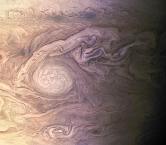
White oval on Jupiter during Juno’s Perijove 4 pass on February 2, 2017. Processed from raw data. Credit: NASA/JPL-Caltech/SwRI/MSSS/Kevin M. Gill.
Uncalibrated, processed raw image from Juno’s Perijove 6 pass of Jupiter on May 19, 2017. Credit: NASA/SwRI/MSSS/Jason Major.
Juno spacecraft launched from Cape Canaveral on August 5, 2011. After traveling five years and 1.7 billion miles Juno arrived in orbit at Jupiter on July 4, 2016. The mission will last until at least February 2018, making 11 science orbits around Jupiter, instead of the 32 laps originally planned. Last year, engineers detected a problem with check valves in the propulsion system, and NASA decided to forego an engine burn to move Juno into a tighter 14-day orbit around Jupiter. The current 53.4 day orbit will be maintained, but depending on how the spacecraft responds, NASA could extend the mission another three years to give Juno more flybys near Jupiter.
The next science flyby will occur on July 11, when Juno will get some close-up views of the famous Great Red Spot.
Thanks to everyone who works on these images.
Animation of six images acquired by NASA’s Juno spacecraft on March 27, 2017. Credit: NASA/JPL-Caltech/SwRI/MSSS/Jason Major.
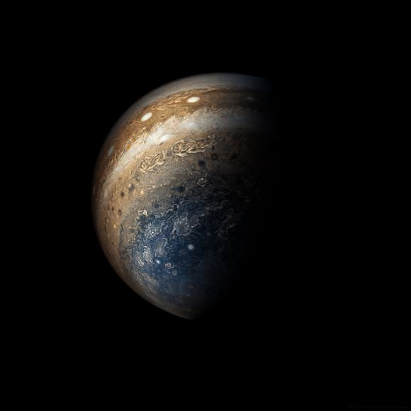
This enhanced color view of Jupiter’s south pole was created by citizen scientist Gabriel Fiset using data from the JunoCam instrument on NASA’s Juno spacecraft. Oval storms dot the cloudscape. Approaching the pole, the organized turbulence of Jupiter’s belts and zones transitions into clusters of unorganized filamentary structures, streams of air that resemble giant tangled strings. The image was taken on Dec. 11, 2016 at 9:44 a.m. PST (12:44 p.m. EST), from an altitude of about 32,400 miles (52,200 kilometers) above the planet’s beautiful cloud tops. Credits: NASA/JPL-Caltech/SwRI/MSSS/Gabriel Fiset
Before we really get started on today’s episode, I’d like to share a bunch of really cool pictures created by my friend Kevin Gill. Kevin’s a computer programmer, 3-D animator and works on climate science data for NASA.
And in his spare time, he uses his skills to help him imagine what the Universe could look like. For example, he’s mapped out what a future terraformed Mars might look like based on elevation maps, or rendered moons disturbing Saturn’s rings with their gravity.
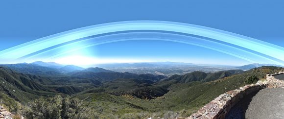
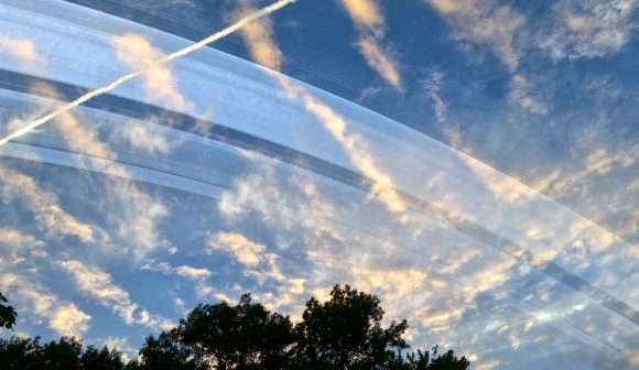
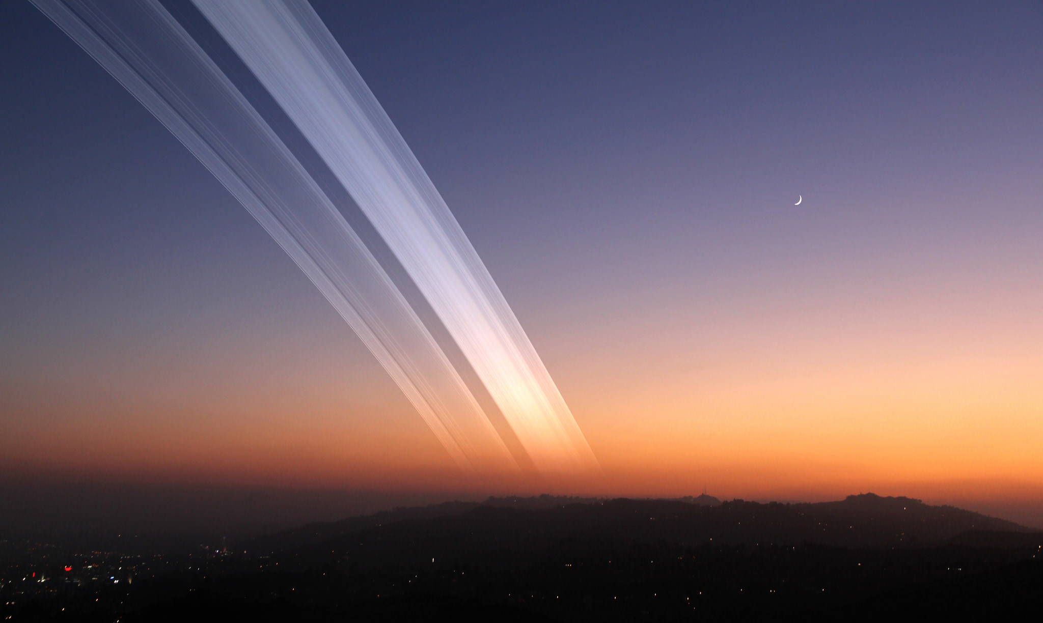
Earth’s Rings over San Bernadino. Credit: Kevin Gill (CC BY-SA 2.0)
But one of my favorite sets of images that Kevin did were these. What would it look like if Earth had rings? Kevin and his wife went to a few cool locations, took some landscape pictures, and then Kevin did the calculations for what it would look like if Earth had a set of rings like Saturn.
And let me tell you, Earth would be so much better. At least you’d think so, but actually, it might also suck.
Last time I checked, we don’t have rings like this. In fact, we don’t have any rings at all.
Why not? Considering the fact that Saturn, Jupiter, Uranus and Neptune all have rings, don’t we deserve at least something?
Did we ever have rings in the past, or will we in the future? What’s it going to take for us to join the ring club? Short answer, an apocalypse.
Before we get into the inevitable discussion of death and devastation, let’s talk a bit about rings.
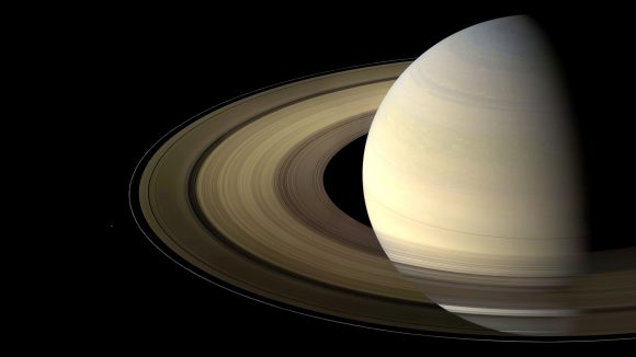
A lovely view of Saturn and its rings as seen by the Cassini spacecraft on Aug. 12, 2009. Credit: NASA/JPL-Caltech/Space Science Institute.
Saturn is the big showboat, with its fancy rings. They’re made of water ice, with chunks as big as a mountain, or as small as a piece of sand. Astronomers have been arguing about where they came from and how old they are, but the current consensus – sort of – is that the rings are almost as ancient as Saturn itself: billions of years old. And yet, some process is weathering the rings, grinding the particles so they appear much younger.
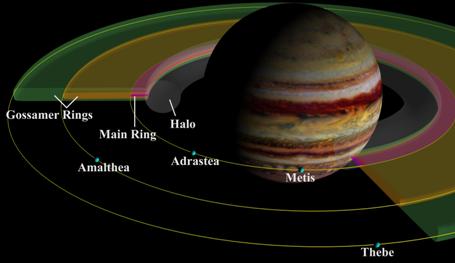
Jupiter’s rings. Image Credit: University of Maryland
Jupiter’s rings are much fainter, and we didn’t even know about them until 1979, when the Voyager spacecraft made their flybys. The rings seem to be created by dust blown off into space by impacts on the planet’s moons.
Hey, we’ve got a moon, that’s a sign.
Uranus imaged by Voyager 2 in 1986. Credit: NASA
The rings around Uranus are bigger and more complex than Jupiter’s rings, but not as substantial as Saturn’s. They’re much younger, perhaps only 600 million years old, and appear to have been caused by two moons crashing into each other, long ago.
Again, another sign. We still have the potential for stuff to crash around us.
The labeled ring arcs of Neptune as seen in newly processed data. The image spans 26 exposures combined into a equivalent 95 minute exposure, and the ring trace and an image of the occulted planet Neptune is added for reference. Credit: M. Showalter/SETI Institute
The rings around Neptune are far dustier than any of the other ring systems, and much younger than the Solar System. And like the rings around Uranus, they were probably formed when two or more of its moons collided together.
Now what about our own prospects for rings?
The problem with icy rings is that the Earth orbits too closely to the Sun. There’s a specific point in the Solar System known as the “frost line” or “snow line”. This is the point in the Solar System where deposits of ice could have survived for long periods of time. Any closer and the radiation from the Sun sublimates the ice away.
This point is actually located about 5 astronomical units away from the Sun, in the asteroid belt. Mars is much closer, so it’s very dry, while Jupiter is beyond the frost line, and its moons have plenty of water ice.
The Earth is a mere 1 AU from the Sun. That’s the very definition of an astronomical unit, which means it’s well within the frost line. The Earth itself can maintain water because the planet’s magnetosphere acts like a shield against the solar wind. But the Moon is bone dry (except for the permanently shadowed craters at its poles).
And if there was an icy ring system around the Earth, the solar wind would have blasted it away long ago.
Instead, let’s look at another kind of ring we can have. One made of rock and dust, containing death and sorrow, from a pulverized asteroid or moon. In fact, billions of years ago, we definitely had a ring when a Mars-sized planet crashed into the Earth and spewed out a massive ring of debris. This debris collected together into the Moon we know today. That impact turned the Earth’s surface inside out. It was all volcanoes, everywhere, all the time.
Credit: Kevin Gill (CC BY-SA 2.0)
It’s also possible we had a second moon in the ancient past, which collided with our current Moon. That would have generated an all new ring of material for millions of years until it was recaptured by the Moon, kicked out of orbit, or fell down onto the Earth.
It’s that “fell down onto Earth” part that’s apocalyptic. As mountains of ring material entered the Earth’s atmosphere, it would increase the temperature, baking and boiling away any life that couldn’t burrow deep underground.
It’s kind of like the book Seveneves, which you should totally read if you haven’t already. It talks about what we would see if the Moon broke apart into a ring, and the terrible terrible thing that happens next.
Earth’s Rings from New Hampshire. Credit: Kevin Gill (CC BY-SA 2.0)
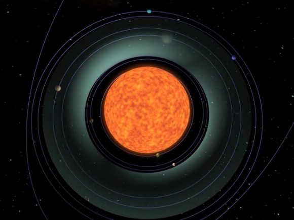
If Earth did get a set of rings, they’d be pretty, but they’d also be a huge pain for astronomers. As you saw in Kevin’s original pictures, the rings take up a huge chunk of the sky for most observers. The farther north or south you go, the more dramatically the rings will ruin your view. Only if you were right at the equator, you’d have a thin line, which would be borderline acceptable.
Furthermore, the rings themselves would be incredibly reflective, and completely ruin the whole concept of dark skies. You know how the Moon sucks for astronomy? Rings would be way way worse.
Finally, rings would interfere with our ability to launch spacecraft and maintain satellites. It depends on how far they extend, but we wouldn’t be able to have any satellites in that region or cross the ring plane. Oh, and that fiery death apocalypse I mentioned earlier.
We know that the Moon is drifting away from the Earth right now thanks to the conservation of angular momentum. But in the distant future, billions of years from now, there might be a scenario that turns everything around.
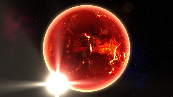
The Sun’s habitable zone in its red giant phase. Credit: NASA/Goddard Space Flight Center Conceptual Image Lab
As you know, when it runs out of fuel in its core, the Sun is going to bloat up as a red giant, consuming Mercury and Venus. Scientists are on the fence about Earth. Some think that Earth will be fine. The Sun will blast off its outer layers, but not actually envelop Earth. Others think that at the Sun’s largest point, we’ll be orbiting within the outer atmosphere of the Sun. Ouch, that’s hot.
The orbiting Moon will experience drag as it goes around the Earth, slowing down its orbital velocity, and causing it to spiral inward. Once it reaches the Roche Limit of the Earth, about 9,500 km, our planet’s gravity will tear the Moon apart into a ring. The chunks in the ring will also experience drag in the solar atmosphere and continue to spiral inward until they crash into the planet.
The Moon tearing apart to become a ring around Earth. Credit: Universe Sandbox ²
That would be considered a very bad day, if it wasn’t for the fact that we were already living inside the atmosphere of the Sun. No amount of terraforming will fix that.
Sadly, the Earth doesn’t have rings like Saturn, and it probably never did. It might have had rings of rock and dust for periods, but they weren’t that majestic to look at. In fact, seeing rings around the planet would mean we’d lost a moon, and our planet was about go through a period of bombardment. I’ll pass.
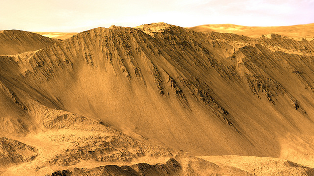
The rim of Tooting Crater on Mars, rendered from HiRISE data using Autodesk Maya and Adobe Photoshop. Credit: NASA/JPL/University of Arizona/USGS/image editing by Kevin Gill.
By day, Kevin Gill is a software engineer at the Jet Propulsion Laboratory. But on nights and weekends he takes data from spacecraft and turns them into scenes that can transport you directly to the surface of Mars.
Gill is one of many so-called “amateur” image editing enthusiasts that take real, high-resolution data from spacecraft and create views that can make you feel like you are standing on the surface of Mars, or out flying around the Solar System.
Gasa Crater on Mars. Rendered using Autodesk Maya and Adobe Photoshop. HiRISE data processed using HiView and gdal. Credit: NASA/JPL/University of Arizona/USGS/image editing by Kevin Gill.
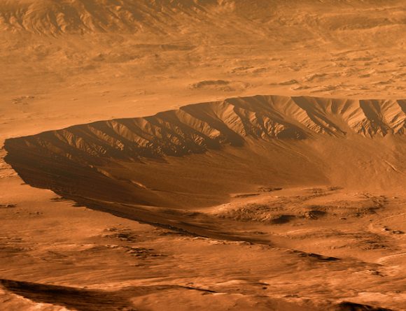
Some of the best data around for these purposes come from the HiRISE camera on board the Mars Reconnaissance Orbiter. Data known as Digital Terrain Model (DTM) files, the HiRISE DTMs are made from two or more images of the same area of a region on Mars, taken from different angles. This data isn’t just for making stunning images or amazing movies. For scientists, DTMs are very powerful research tools, used to take measurements such a elevation information and model geological processes.
So, just how do you go from this DTM image from HiRISE:
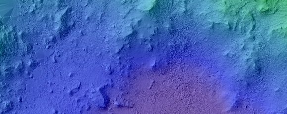
DTM image of the Central Peak of Elorza Crater on Mars. Credit: NASA/JPL/University of Arizona/USGS
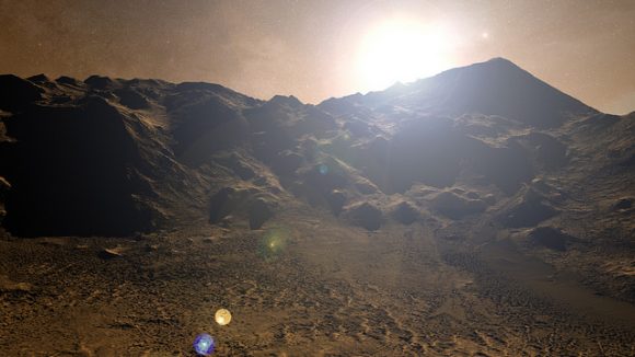
To this amazing image?
Martian sunrise over the Central Peak of Elorza Crater. Rendered using Autodesk Maya and Adobe Photoshop. HiRISE data processed using HiView and gdal. Credit: NASA/JPL/University of Arizona/USGS/image editing by Kevin Gill
I’m going to let Kevin explain it:
To prep the data, I use Photoshop (to convert the JP2 file to a TIFF), and then standard GIS tools like gdal (Geospatial Data Abstraction Library) to create textures for 3D modeling. Using Autodesk Maya, I input those into a material as a color texture (orthoimagery) or displacement map (the DTM data).
I connect that material to a NURBS plane (sort of like a polygon mesh) that is scaled similarly to the physical properties of the data. I set up a camera at a nice angle (it takes a number of low-resolution test renders to get an angle I like) and let it render.
Then I just pull that render into Photoshop where I have a series of monochromatic color tints which gives the image it’s Martian feel. For the sky, I use either a sky from a MSL MastCam image or one that I took outside with my cell phone. If I’m using a sky I took with my cell phone, I’ll adjust the colors to make it look more like it would on Mars. If the colors in the image are still boring at this point, I may run a HDR adjustment on it in Photoshop.
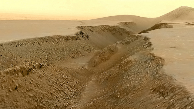
Fissure in the Cerberus region. This false color view of a volcanic fissure in the Cerberus region of Mars was created using a digital terrain model (DTM) from the High Resolution Imaging Science Experiment (HiRISE) camera aboard NASA’s Mars Reconnaissance Orbiter. The horizon was taken from Curiosity Mastcam imagery. Credit: NASA/JPL-Caltech/University of Arizona/ image editing by Kevin Gill.
What all this means is that you can create all these amazing view, plus incredible flyover videos, like this one Kevin put together of Endeavour Crater:
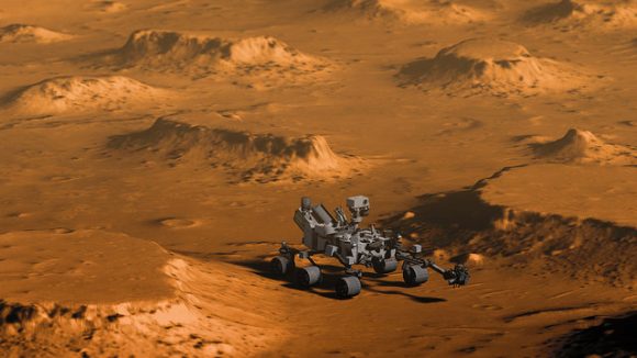
Or you can have some fun and visualize where the Curiosity rover is sitting:
Doin’ Science with Curiosity. Created using HiRIST DTM and Ortho data and NASA model of Curiosity. Rendered using Autodesk Maya and Adobe Photoshop. Curiosity Model: Brian Kumanchik, NASA/JPL-Caltech. Image editing by Kevin Gill.
We’ve written about this type of image editing previously, with the work of the people at UnmannedSpaceflight.com and others. Of course, the image editing software keeps improving, along with all the techniques.
Kevin also wanted to point out the work of other image editing enthusiast, Sean Doran.
“Sean’s work is resulting in views similar to mine,” Kevin said via email. “I know he’s using a process very different from mine, but we are thinking along the same lines in what we want out of the end product. His are quite impressive.”
For example, here is a flyover video of the Opportunity rover sitting along the rim of Endeavour Crater:
What would Earth look like if it had a ring system like Saturn's. Credit: Kevin Gill/Flickr
Saturn’s Rings are amazing to behold. Since they were first observed by Galileo in 1610, they have been the subject of endless scientific interest and popular fascination. Composed of billions of particles of dust and ice, these rings span a distance of about 282,000 km (175,000 miles) – which is three quarters of the distance between the Earth and its Moon – and hold roughly 30 quintillion kilograms (that’s 3.0. x 1018 kg) worth of matter.
All of the Solar System’s gas giants, from Jupiter to Neptune, have their own ring system – albeit less visible and picturesque ones. Sadly, none of the terrestrial planets (i.e. Mercury, Venus, Earth and Mars) have such a system. But just what would it look like if Earth did? Putting aside the physical requirements that it would take for a ring system to exist, what would it be like to look up from Earth and see beautiful rings reaching overhead?