This zoomed-in image of Uranus, captured by Webb’s Near-Infrared Camera (NIRCam) Feb. 6, 2023, reveals stunning views of the planet’s rings. The planet's upper atmosphere has been cooling for decades, New research has an explanation. Credit: NASA, ESA, CSA, STScI
IMAGE PROCESSING: Joseph DePasquale (STScI).
Uranus is an oddball among the Solar System’s planets. While most planets’ axis of rotation is perpendicular to their orbital plane, Uranus has an extreme tilt angle of 98 degrees. It’s flopped over on its side, likely from an ancient collision. It also has a retrograde rotation, opposite of the other planets.
The ice giant also has an unusual relationship with the Sun that sets it apart from other planets.
Ionospheric VTEC from phones during a geomagnetic storm
We are all familiar with the atmosphere of the Earth and part of this, the ionosphere, is a layer of weakly ionized plasma. It extends from 50 to 1,500 km above the planet. It’s a diffuse layer but sufficient to interfere with satellite communications and navigation systems too. A team of researchers have come up with an intriguing idea to utilise millions of mobile phones to help map the ionosphere by relying on their GPS antennas.
NASA's Endurance Rocket lifts off from Svalbard in 2022. The results are in and the rocket successfully measured Earth's global electric field. Image Credit: NASA/Brian Bonsteel
Scientists have discovered that Earth has a third field. We all know about the Earth’s magnetic field. And we all know about Earth’s gravity field, though we usually just call it gravity.
Now, a team of international scientists have found Earth’s global electric field.
Left shows an image of a piece of sky observed with the hitherto best calibration technique. Right shows the same piece of sky with the new technique. More detail is visible, and what were once large, blurry patches now appear as single points. (c) LOFAR/Groeneveld et al.
Radio telescopes have an advantage over optical telescopes, in that radio telescope can be used even in cloudy conditions here on Earth. That’s because the longer wavelengths of radio waves can pass through clouds unhindered. However, some wavelengths are still partially obscured by portions of Earth’s atmosphere, especially by the ionosphere which traps human-made Radio Frequency Interference (RFI).
Astronomers have developed a new calibration technique that allows them to take sharp images in low radio frequencies — between 16 and 30 MHz — for the first time, bypassing the influence of the ionosphere. The astronomers say this will allow them to study things like plasmas emanating from ancient black holes and perhaps even detect exoplanets that orbit small stars.
Mega-constellations of satellites. Credit: ESA-Science Office
Hardly a day goes by where a story hits the headlines about our abuse of the Earth’s precious environment be that the atmosphere or the oceans, forests or desert. When it comes to the atmosphere we all tend to immediately turn our attention to pollution, to gasses being released and disturbing the delicate balance. Yet a paper recently published points to a new demon, megaconstellations of satellites damaging the ionosphere – the ionised part of the upper atmosphere.
The Parker Solar Probe has been getting in a lot of extracurricular activity lately. Originally designed to observe the Sun, the probe has been taking full advantage of its path through the solar system. In addition to snapping pictures of comets, the probe has repeatedly focused on Venus, including capturing an image peering underneath the cloud cover of the notoriously hot world. Now a team led by Glyn Collinson of Goddard Space Flight Center found another serendipitous discovery in the data Parker collected during its latest flyby in the summer of 2020 – the probe actually flew through Venus’ upper atmosphere, and that atmosphere appeared different than it was almost 30 years ago.
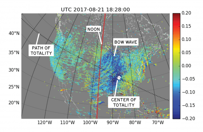
This graphic shows atmospheric bow waves forming during the August 2017 eclipse over the continental United States. Image: Shunrong Zhang/Haystack Observatory
It’s long been predicted that a solar eclipse would cause a bow wave in Earth’s ionosphere. The August 2017 eclipse—called the “Great American Eclipse” because it crossed the continental US— gave scientists a chance to test that prediction. Scientists at MIT’s Haystack Observatory used more than 2,000 GNSS (Global Navigation Satellite System) receivers across the continental US to observe this type of bow wave for the first time.
The Great American Eclipse took 90 minutes to cross the US, with totality lasting only a few minutes at any location. As the Moon’s shadow moved across the US at supersonic speeds, it created a rapid temperature drop. After moving on, the temperature rose again. This rapid heating and cooling is what caused the ionospheric bow wave.
The bow wave itself is made up of fluctuations in the electron content of the ionosphere. The GNSS receivers collect very accurate data on the TEC (Total Electron Content) of the ionosphere. This animation shows the bow wave of electron content moving across the US.
The details of this bow wave were published in a paper by Shun-Rong Zhang and colleagues at MIT’s Haystack Observatory, and colleagues at the University of Tromso in Norway. In their paper, they explain it like this: “The eclipse shadow has a supersonic motion which [generates] atmospheric bow waves, similar to a fast-moving river boat, with waves starting in the lower atmosphere and propagating into the ionosphere. Eclipse passage generated clear ionospheric bow waves in electron content disturbances emanating from totality primarily over central/eastern United States. Study of wave characteristics reveals complex interconnections between the sun, moon, and Earth’s neutral atmosphere and ionosphere.”
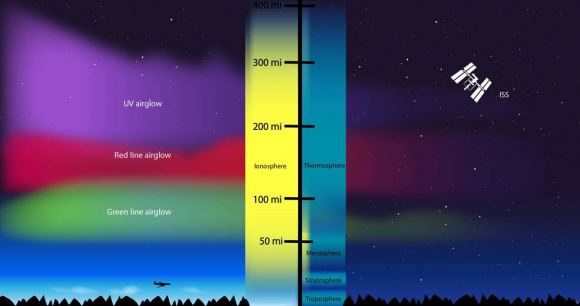
The ionosphere stretches from about 50 km to 1000 km in altitude during the day. It swells as radiation from the Sun reaches Earth, and subsides at night. Its size is always fluctuating during the day. It’s called the ionosphere because it’s the region where charged particles created by solar radiation reside. The ionosphere is also where auroras occur. But more importantly, it’s where radio waves propagate.
The ionosphere surrounds the Earth, extending from about 80 km to 650 km. Image Credit: NASA’s Goddard Space Flight Center/Duberstein
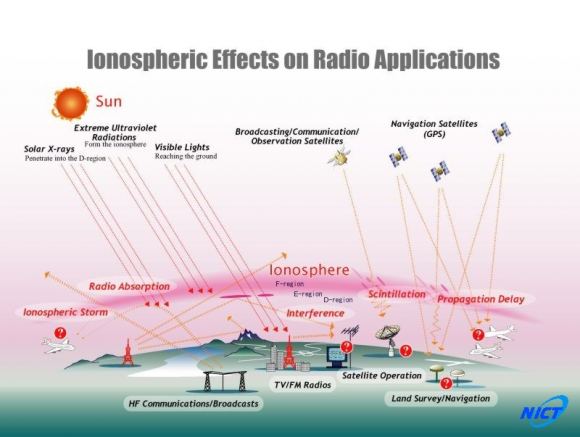
The ionosphere plays an important role in the modern world. It allows radio waves to travel over the horizon, and also affects satellite communications. This image shows some of the complex ways our communications systems interact with the ionosphere.
This graphic shows some of the effects that the ionosphere has on communications. Image: National Institute of Information and Communications Technology
There’s a lot going on in the ionosphere. There are different types of waves and disturbances besides the bow wave. A better understanding of the ionosphere is important in our modern world, and the August eclipse gave scientists a chance not only to observe the bow wave, but also to study the ionosphere in greater detail.
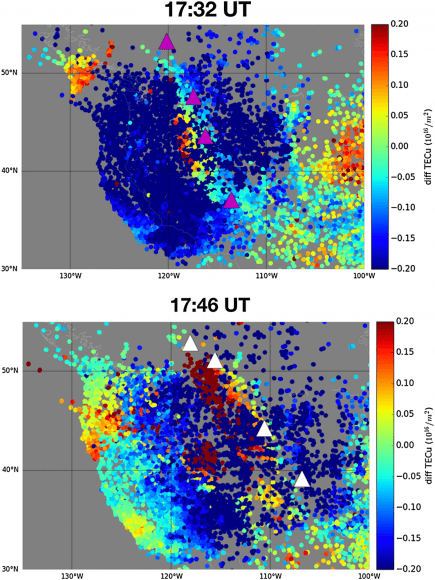
The GNSS data used to observe the bow wave was key in another study as well. This one was also published in the journal Geophysical Research Letters, and was led by Anthea Coster of the Haystack Observatory. The data from the network of GNSS was used to detect the Total Electron Content (TEC) and the differential TEC. They then analyzed that data for a couple things during the passage of the eclipse: the latitudinal and longitudinal response of the TEC, and the presence of any Travelling Ionospheric Disturbances (TID) to the TEC.
Predictions showed a 35% reduction in TEC, but the team was surprised to find a reduction of up to 60%. They were also surprised to find structures of increased TEC over the Rocky Mountains, though that was never predicted. These structures are probably linked to atmospheric waves created in the lower atmosphere by the Rocky Mountains during the solar eclipse, but their exact nature needs to be investigated.
This image of GNSS data shows the positive Travelling Ionospheric Disturbance (TID) structure in the center of the primary TEC depleted region. The triangles mark cities in or near the Rocky Mountains. Image: Coster et. al.
“… a giant active celestial experiment provided by the sun and moon.” – Phil Erickson, assistant director at Haystack Observatory.
“Since the first days of radio communications more than 100 years ago, eclipses have been known to have large and sometimes unanticipated effects on the ionized part of Earth’s atmosphere and the signals that pass through it,” says Phil Erickson, assistant director at Haystack and lead for the atmospheric and geospace sciences group. “These new results from Haystack-led studies are an excellent example of how much still remains to be learned about our atmosphere and its complex interactions through observing one of nature’s most spectacular sights — a giant active celestial experiment provided by the sun and moon. The power of modern observing methods, including radio remote sensors distributed widely across the United States, was key to revealing these new and fascinating features.”
The Great American Eclipse has come and gone, but the detailed data gathered during that 90 minute “celestial experiment” will be examined by scientists for some time.
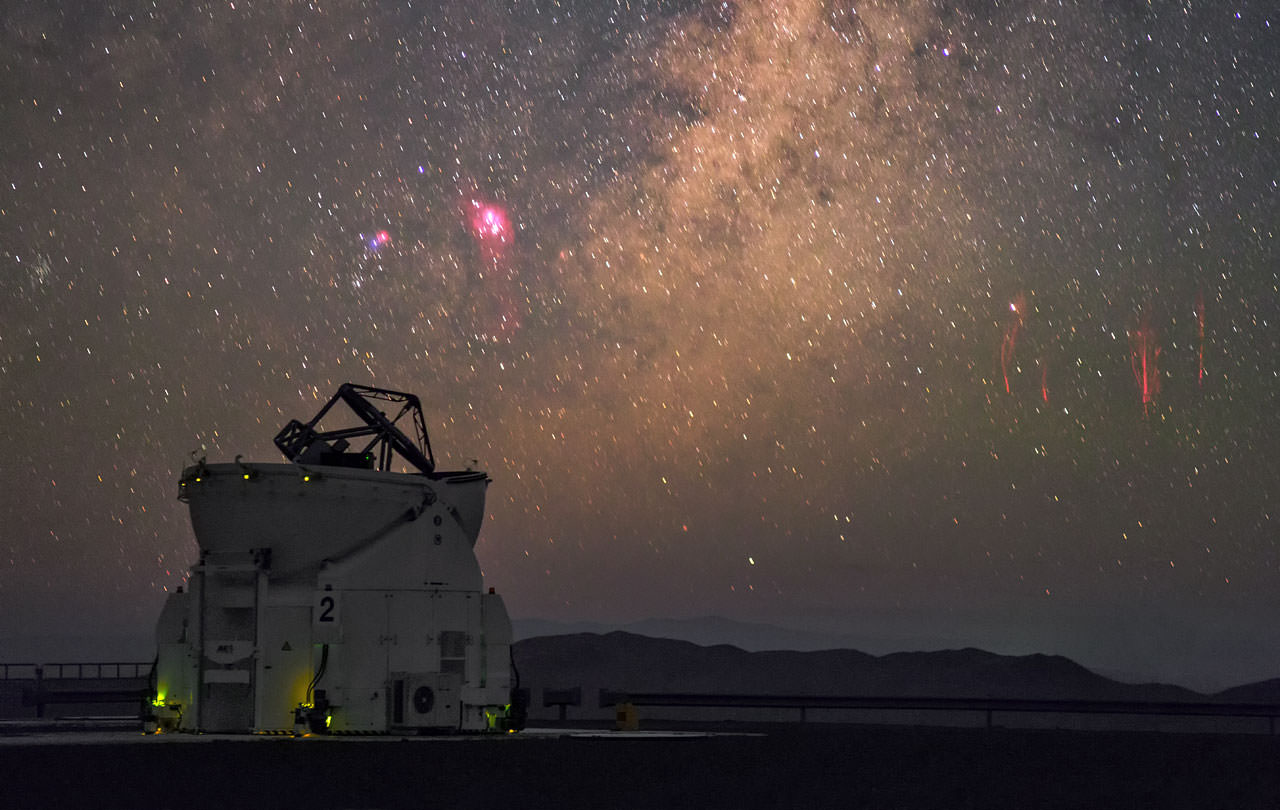
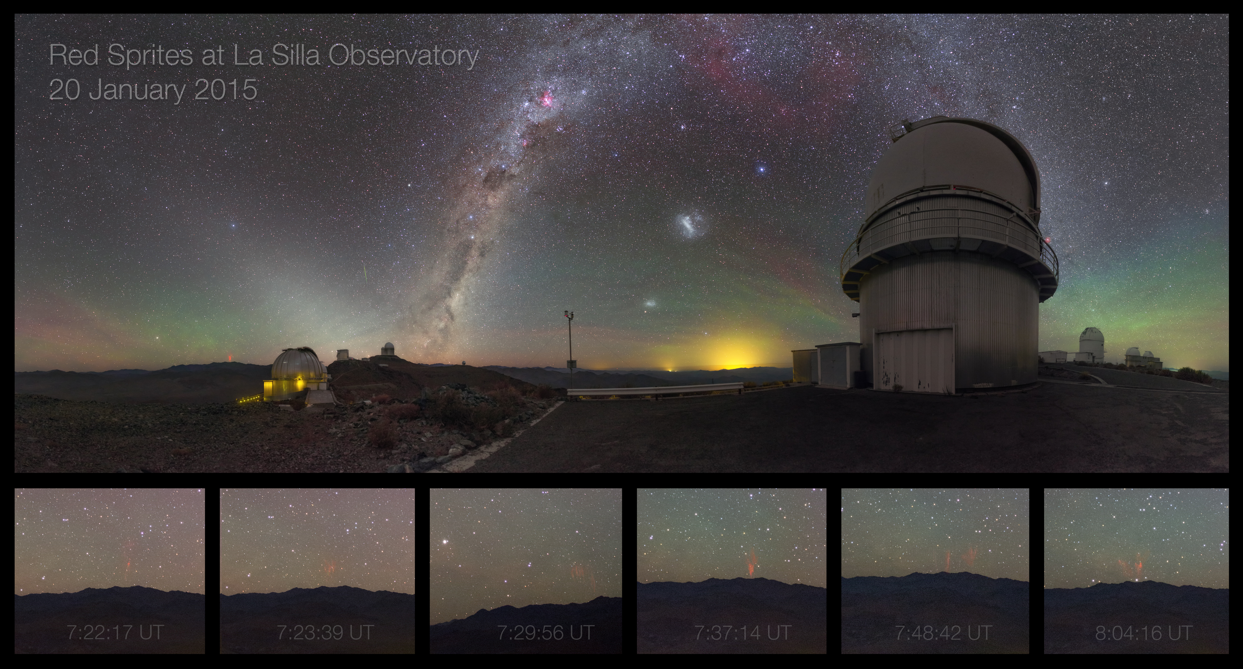
Distant sprites (right) captured from ESO's VLT by Photo Ambassador Petr Horálek. (P. Horálek/ESO)
At the ESO’s observatories located high in the Atacama Desert of Chile, amazing images of distant objects in the Universe are captured on a regular basis. But in January 2015, ESO photo ambassador Petr Horálek captured some amazing photos of much closer phenomena: red sprites flashing in the atmosphere high above distant thunderstorms.
The photo above was captured from ESO’s Paranal Observatory. A few days earlier during the early morning hours of Jan. 20 Petr captured another series of sprites from the La Silla site, generated by a storm over Argentina over 310 miles (500 km) away.
Sprites spotted from ESO’s La Silla observatory by Petr Horálek (left horizon)
So-named because of their elusive nature, sprites appear as clusters of red tendrils above a lighting flash, often extending as high as 55 miles (90 km) into the atmosphere. The brightest region of a sprite is typically seen at altitudes of over 40-45 miles (65-75 km).
Because they occur high above large storms, only last for fractions of a second and emit light in the portion of the spectrum to which our eyes are the least sensitive, observing sprites is notoriously difficult.
These furtive atmospheric features weren’t captured on camera until 1989. Continuing research has since resulted in more images, including some from the International Space Station. When they are spotted, sprites – and their lower-altitude relatives blue jets – can appear as bright as moderate aurorae and have also been found to emit radio noise. It has even been suggested that looking for sprite activity on other planets could help identify alien environments that are conducive to life.
Find out more about sprite research from the University of Alaska Fairbanks, and check out the PBS NOVA program “At the Edge of Space” below about a sprite hunt in the skies over Denver, CO conducted by a team of American scientists and Japanese filmmakers.
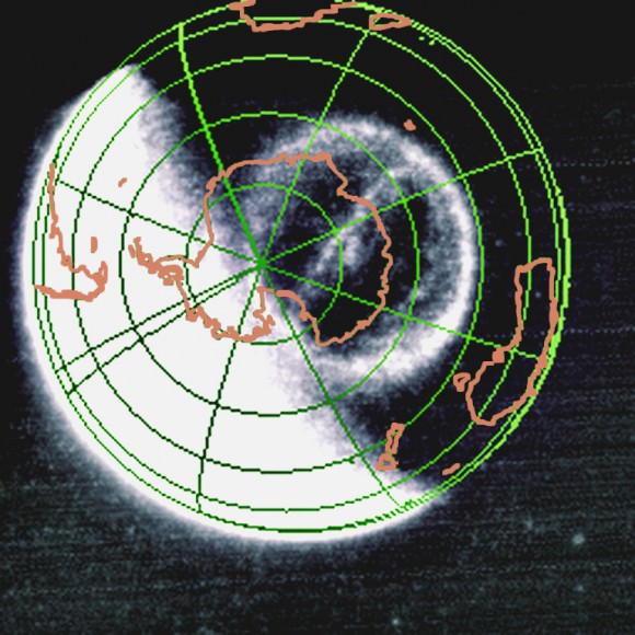
From the ground, aurora have mystified humans since we began to question the world. The space age revealed more mystery - the Theta Auroral Oval (inset) and the challenge of understanding the phenomena. (Photo Credit: NASA/APOD)
The mystery of the northern lights – aurora – spans time beyond history and to cultures of both the southern and northern hemispheres. The mystery involves the lights, fantastic patterns and mystical changes. Ancient men and women stood huddled under them wondering what it meant. Was it messages from the gods, the spirits of loved ones, warnings or messages to comfort their souls?
Aurora reside literally at the edge of space. While we know the basics and even more, we are still learning. A new published work has just added to our understanding by explaining how one type of aurora – the Theta Aurora – is created from the interaction of the charged particles, electric and magnetic fields surrounding the Earth. Their conclusions required the coordination of simultaneous observations of two missions.
The Theta Auroral Oval as observed by the NASA IMAGE FUV camera on September 15, 2005 and anlayzed using Cluster data in the paper by Fear et al. (Credit: NASA/SWRI)
We were not aware of Thetas until the advent of the space age and our peering back at Earth. They cannot be recognized from the ground. The auroras that bystanders see from locales such as Norway or New Zealand are just arcs and subsets of the bigger picture which is the auroral ovals atop the polar regions of the Earth. Ground based all-sky cameras and polar orbiting probes had seen what were deemed “polar cap arcs.” However, it was a spacecraft Dynamics Explorer I (DE-1) that was the first to make global images of the auroral ovals and observed the first “transpolar arcs”, that is, the Theta aurora.
They are named Theta after the Greek letter that they resemble. Thetas are uncommon and do not persist long. Early on in the exploration of this phenomenon, researchers have been aware that they occur when the Sun’s magnetic field, called the Interplanetary Magnetic Field (IMF) turns northward. Most of the time the IMF in the vicinity of the Earth points south. It is a critical aspect of the Sun-Earth interaction. The southerly pointing field is able to dovetail readily with the normal direction of the Earth’s magnetic field. The northward IMF interacting with the Earth’s field is similar to two bar magnets turned head to head, repelling each other. When the IMF flips northward locally, a convolution takes place that will, at times, but not always, produce a Theta aurora.
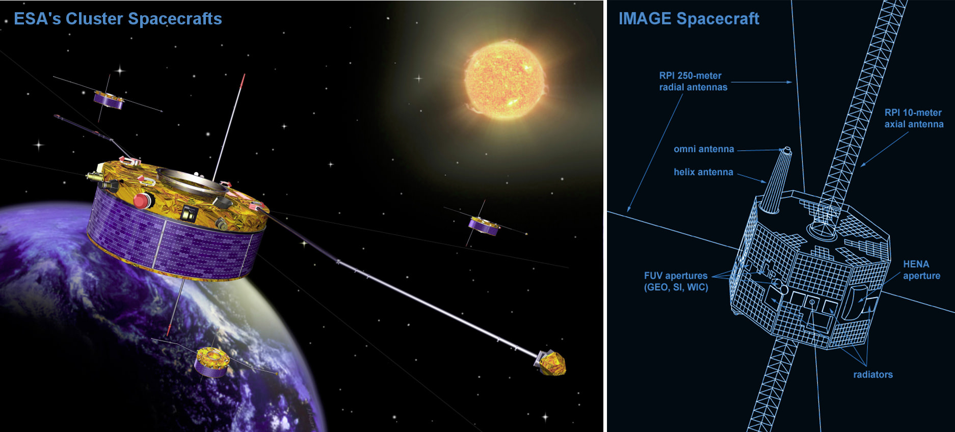
A group of researchers led by Dr. Robert Fear from the Department of Physics & Astronomy, University of Leicester, through analysis of simultaneous spacecraft observations, has identified how the particles and fields interact to produce Theta aurora. Their study, “Direct observation of closed magnetic flux trapped in the high-latitude magnetosphere” in the Journal Science (December 19, 2014, Vol 346) utilized a combination of data from ESA’s Cluster spacecraft mission and the IMAGE spacecraft of NASA. The specific event in the Earth’s magnetosphere on September 15, 2005 was observed simultaneously by the spacecraft of both missions.
Illustrations of the Cluster II spacecraft in orbit and formation around the Earth and the NASA IMAGE spacecraft vehicle design. The two mission’s observations were combined to correlate numerous auroral and magnetospheric events. Cluster II remains in operation as of December 2014 (14 yr lifespan). (Credit: ESA, NASA)
Due to the complexity of the Sun-Earth relationship involving neutral and charged particles and electric and magnetic fields, space scientists have long attempted to make simultaneous measurements with multiple spacecraft. ISEE-1, 2 and 3 were one early attempt. Another was the Dynamics Explorer 1 & 2 spacecraft. DE-2 was in a low orbit while DE-1 was in an elongated orbit taking it deeper into the magnetosphere. At times, the pair would align on the same magnetic field lines. The field lines are like rails that guide the charged particles from far out in the magneto-tail to all the way down to the upper atmosphere – the ionosphere. Placing two or more spacecraft on the same field lines presented the means of making coordinated observations of the same event. Dr. Fear and colleagues analyzed data when ESA’s Cluster resided in the southern lobe of the magnetotail and NASA’s IMAGE (Imager for Magnetopause-to-Aurora Global Exploration) spacecraft resided above the south polar region of the Earth.
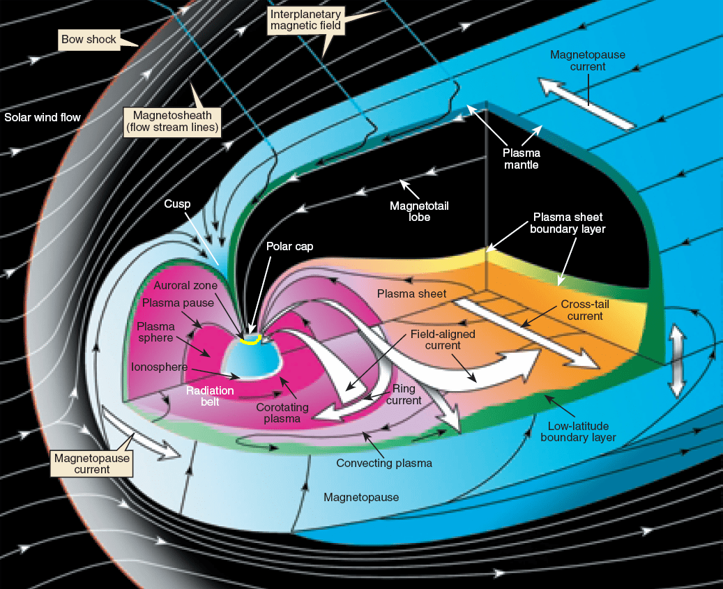
Cluster is a set of four spacecraft, still in operation after 14 years. Together with IMAGE, five craft were observing the event. Fear, et al utilized ESA spacecraft Cluster 1 (of four) and NASA’s IMAGE. On that fateful day, the IMF turned north. As described in Dr. Fear’s paper, on that day, the north and south lobes of the magnetosphere were closed. The magnetic field lines of the lobes were separated from the Solar wind and IMF due to what is called magnetic reconnection. The following diagram shows how complex Earth’s magnetosphere is; with regions such as the bow shock, magnetopause, cusps, magnetotail, particle belts and the lobes.
Illustration of the Earth’s magnetosphere showing it complexity. The Theta Aurora are now confidently linked to magnetic reconnection events in the lobes of the magnetotail. (Credit: NASA)
The science paper explains that what was previously observed by only lower altitude spacecraft was captured by Cluster within the magnetotail lobes. The southerly lobe’s plasma – ionized particles – was very energetic. The measurements revealed that the southern lobe of the magnetotail was acting as a bottle and the particles were bouncing between two magnetic mirrors, that is, the lobes were close due to reconnection. The particles were highly energetic.
The presence of what is called a double loss cone signature in the electron energy distribution was a clear indicator that the particles were trapped and oscillating between mirror points. The consequences for the Earth’s ionosphere was that highly energetic particles flooded down the field lines from the lobes and impacted the upper atmosphere transferring their energy and causing the magnificent light show that we know as the Northern Lights (or Southern) in the form of a Theta Auroral Oval. This strong evidence supports the theory that Theta aurora are produced by energized particles from within closed field lines and not by energetic particles directly from the Solar Wind that find a path into the magnetosphere and reach the upper atmosphere of the Earth.
A video of an observed major geomagnetic storm (July 15, 2000, southward IMF) taken by the Far Ultraviolet Imaging System (FUV) on the spacecraft IMAGE. IMAGE operated from 2000 until December 2005 when communications were inexplicably lost. (Credit: NASA/SWRI) [click to view the animated gif]Without the coordination of the observations and the collective analysis, the Theta aurora phenomenon would continue to be debated. The analysis by Dr. Fear, while not definitive, is strong proof that Theta aurora are generated from particles trapped within closed field lines.
The analysis of the Cluster mission data as well as that of many other missions takes years. Years after observations are made researchers can achieve new understanding through study of arduous details or sometimes by a ha-ha moment. Aurora represent the signature of the interaction of two magnetic fields and two populations of particles – the Sun’s field and energetic particles streaming at millions of miles per hour from its surface reaching the Earth’s magnetic field. The Earth’s field is transformed by the interaction and receives energetic particles that it bottles up and energizes further. Ultimately, the Earth’s magnetic field directs some of these particles to the topside of our atmosphere. For thousands and likely tens of thousands of years, humans have questioned what it all means. Now another piece of the puzzle has been laid down with a good degree of certainty; one that explains the Theta aurora.
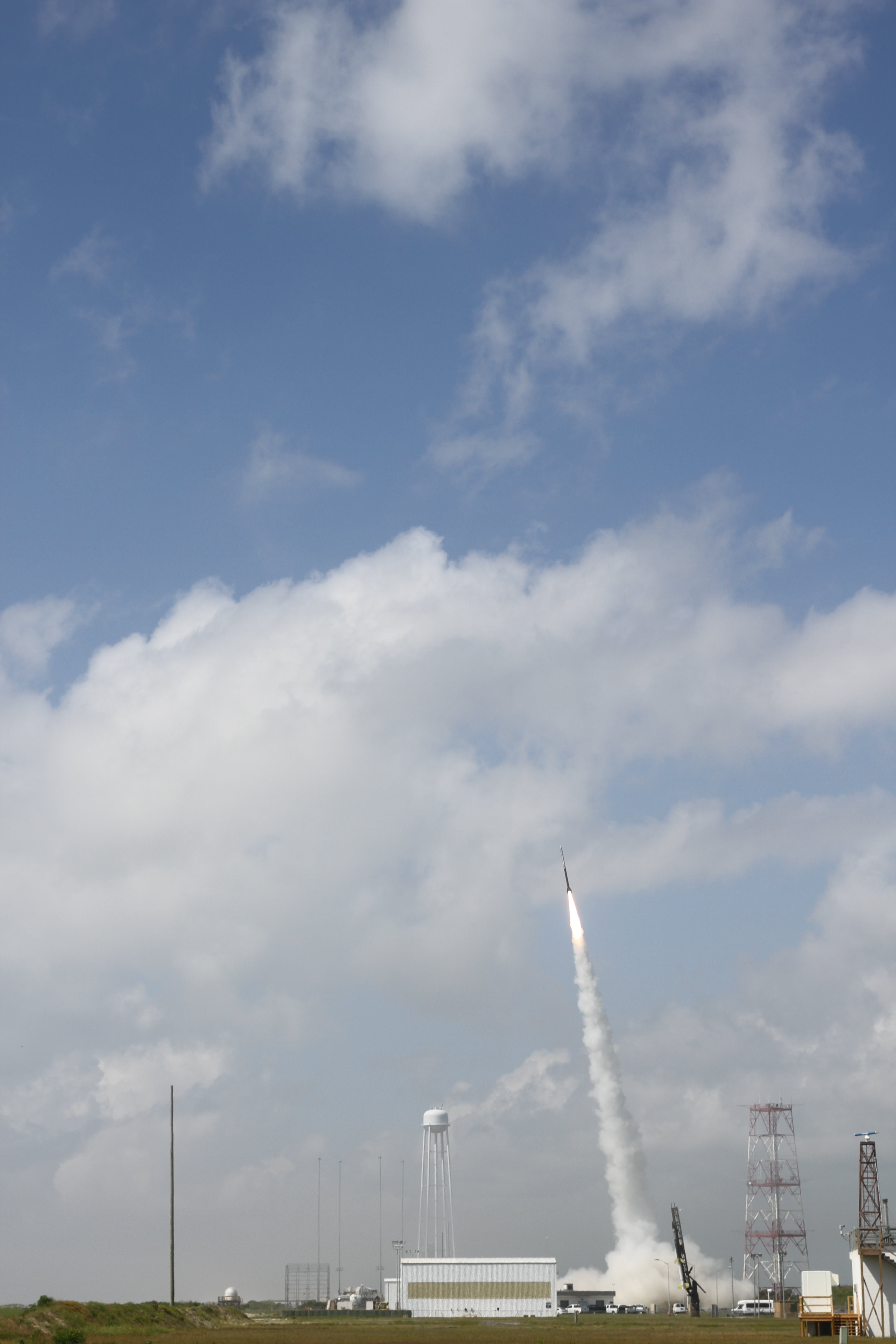
July 4 Morning Fireworks from NASA. A NASA Black Brant V Sounding Rocket launches in support of the Daytime Dynamo Mission on July 4, 2013 from NASA Wallops Flight Facility, VA, Credit NASA/J. Eggers
July 4 Morning Fireworks from NASA!
A NASA Black Brant V Sounding Rocket launches in support of the Daytime Dynamo Mission on July 4, 2013 from NASA Wallops Flight Facility, VA. Credit: NASA/J. Eggers[/caption]
WALLOPS ISLAND, VA – Today, July 4, NASA celebrated America’s Independence Day with a spectacular fireworks display of a dynamic duo of sounding rockets – blasting off barely 15 seconds apart this morning from the agencies NASA Wallops Island facility on the Eastern Shore of Virginia on a science experiment to study the ionosphere.
The goal of the two rocket salvo was an in depth investigation of the electrical currents in Earth’s ionosphere – called the Daytime Dynamo.
The Dynamo electrical current sweeps through the ionosphere, a layer of charged particles that extends from about 30 to 600 miles above Earth.
Disruptions in the ionosphere can scramble radio wave signals for critical communications and navigations transmissions that can impact our every day lives.
The launches suffered multiple delays over the past 2 weeks due to weather, winds, errant boats and unacceptable science conditions in the upper atmosphere.
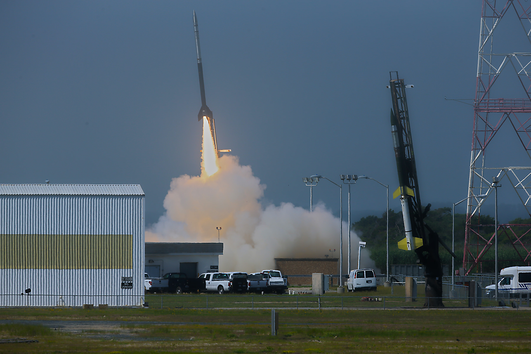
A Black Brant V launches first in support of Daytime Dynamo. Terroer improved Orion (at right) followed 15 seconds later from NASA Wallops on July 4, 2013. Credit: NASA/P. Black
At last, the Fourth of July was the irresistible charm.
The liftoff times were 10:31:25 a.m. for the Black Brant V and 10:31:40 a.m. (EDT) for the Terrier-Improved Orion.
The experiment involved launching two suborbital rockets and also dispatching a NASA King Air airplane to collect a stream of airborne science measurements.
Daytime Dynamo is a joint project between NASA and the Japanese Space Agency, or Japan Aerospace Exploration Agency, or JAXA, said Robert Pfaff to Universe Today in an exclusive interview inside Mission Control at Wallops. Pfaff is the principle investigator for the Dynamo sounding rocket at NASA’s Goddard Space Flight Center in Greenbelt, Md.
“The dynamo changes during the day and varies with the season,” Pfaff told me.
But they only have one chance to launch. So the science team has to pick the best time to meet the science objectives.
“We would launch every month if we could and had the funding, in order to even more fully characterize the Dynamo.”
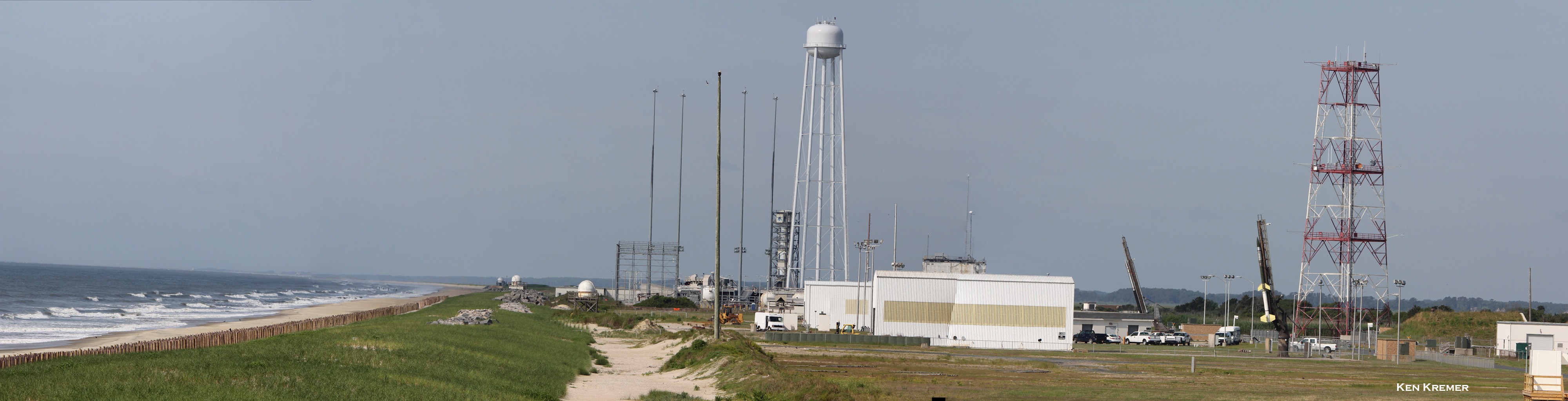
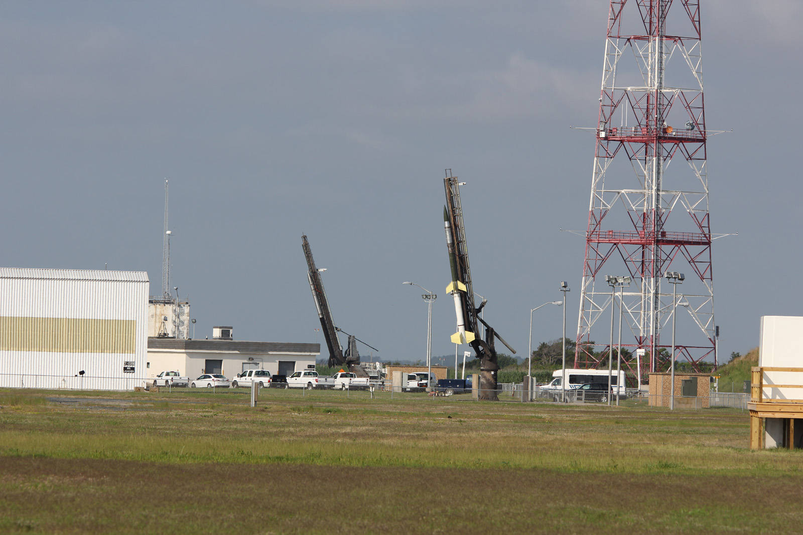
Two rocket salvo comprising a Black Brant V (left) and a Terrier-Improved Orion (right) sit ready to launch as part of the Daytime Dynamo mission in this panoramic view from NASA Wallops Flight Facility at Virginia’s Eastern Shore. Credit: Ken Kremer/kenkremer.com
The 35 foot tall single-stage Black Brant V launched first. It carried a 600 pound payload to collect the baseline data to characterize the neutral and charged ionospheric particles as it blasted skyward.
The 33 foot tall two-stage Terrier-Improved Orion took off just 15 seconds later in the wake of the exhaust of the Black Brant V.
Exhaust trails from Black Brant V and a Terrier-Improved Orion launched in support of Daytime Dynamo mission on July 4, 2013. Credit: NASA/P. Black
The Terrier-Improved Orion successfully deployed a lengthy trail of lithium gas from a pressurized canister that created a chemical tracer to track how the upper atmospheric winds vary with altitude. These winds are believed to be the drivers of the dynamo currents.
Both rockets fly for about five minutes to an altitude of some 100 miles up in the ionosphere. They both splashed down in the ocean after about 15 minutes.
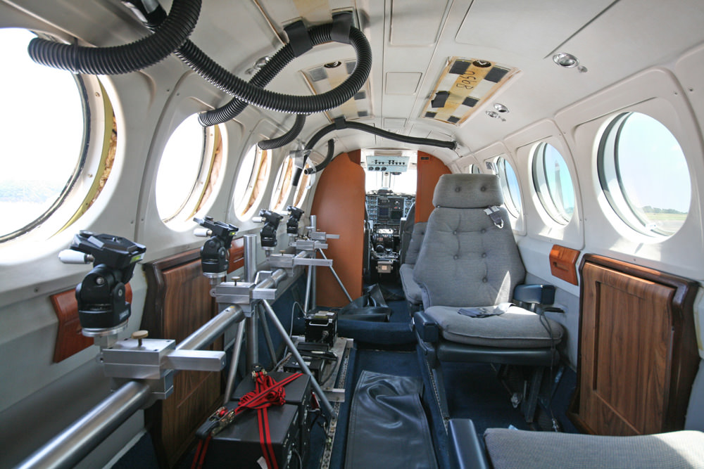
NASA’s King Air aircraft was essential to the mission. I toured the airplane on the Wallops runway for an up-close look inside. It is outfitted with a bank of precisely aimed analytical instruments peering through the aircraft windows to capture the critical science data – see my photos herein.
“The King Air launches about an hour before the scheduled liftoff time,” Pfaff told me.
“It uses special cameras and filters to collect visible and infrared spectroscopic data from the lithium tracer to characterize the daytime dynamo.”
The science instruments are newly developed technology to make the daytime measurements of the lithium tracer and were jointly created by NASA, JAXA and scientists at Clemson University.
“Everything worked as planned,” Pfaff announced from Wallops Mission Control soon after the magnificent Fourth of July fireworks show this morning.
Black Brant V (left) and Terrier-Improved Orion (right) rockets sit on launch pads as part of the Daytime Dynamo mission in this up close view from NASA Wallops Flight Facility at Virginia’s Eastern Shore. Credit: Ken Kremer/kenkremer.com
Inside cabin view of NASA King Air aircraft outfitted with science instrument mounts to support a bank of cameras to capture visible and infrared spectroscopic measurements in support of Daytime Dynamic launches on July 4, 2013. Credit: Ken Kremer/kenkremer.com
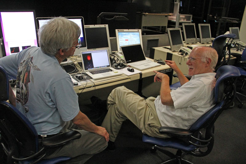
Robert Pfaff (right), Science Principle Investigator and Ken Kremer of Universe Today (left) discuss NASA’s Daytime Dynamo mission inside NASA Wallop’s Mission Control. Credit: Ken Kremer/kenkremer.com


![A video of an observed major geomagnetic storm (July 15, 2000) taken by the Far Ultraviolet Imaging System (FUV) on IMAGE. IMAGE operated from 2000 to December 2005 when communications were lost. (Credit: NASA/SWRI) [click to view the animated gif]](https://www.universetoday.com/wp-content/uploads/2014/12/IMAGE_Aurora-200007151.gif)