Charon Suffered Surprisingly Titanic Upheavals in Fresh Imagery from New Horizons

Charon in Enhanced Color. NASA's New Horizons captured this high-resolution enhanced color view of Charon just before closest approach on July 14, 2015. The image combines blue, red and infrared images taken by the spacecraft’s Ralph/Multispectral Visual Imaging Camera (MVIC); the colors are processed to best highlight the variation of surface properties across Charon. Charon’s color palette is not as diverse as Pluto’s; most striking is the reddish north (top) polar region, informally named Mordor Macula. Charon is 754 miles (1,214 kilometers) across; this image resolves details as small as 1.8 miles (2.9 kilometers). Credits: NASA/JHUAPL/SwRI

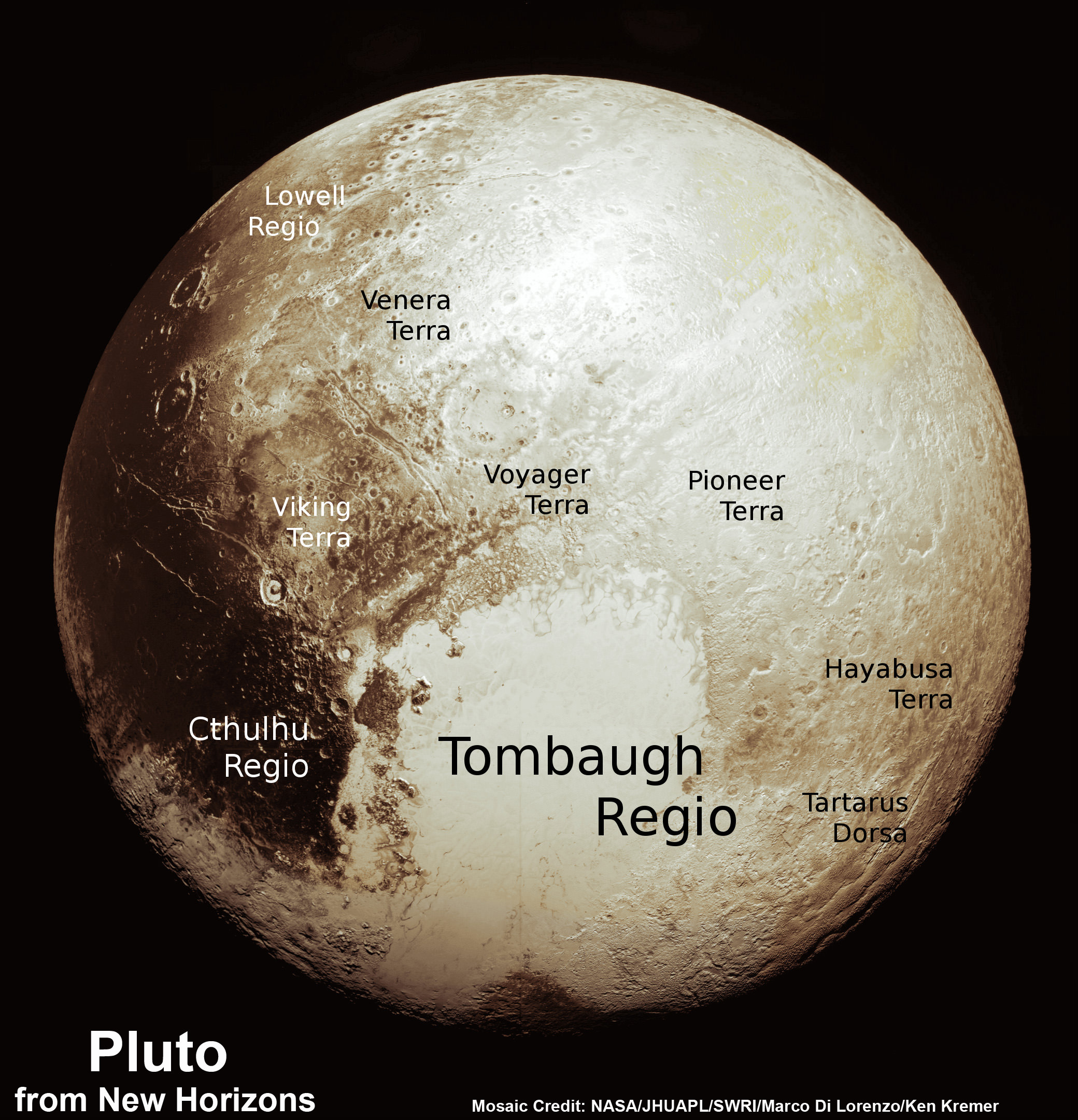
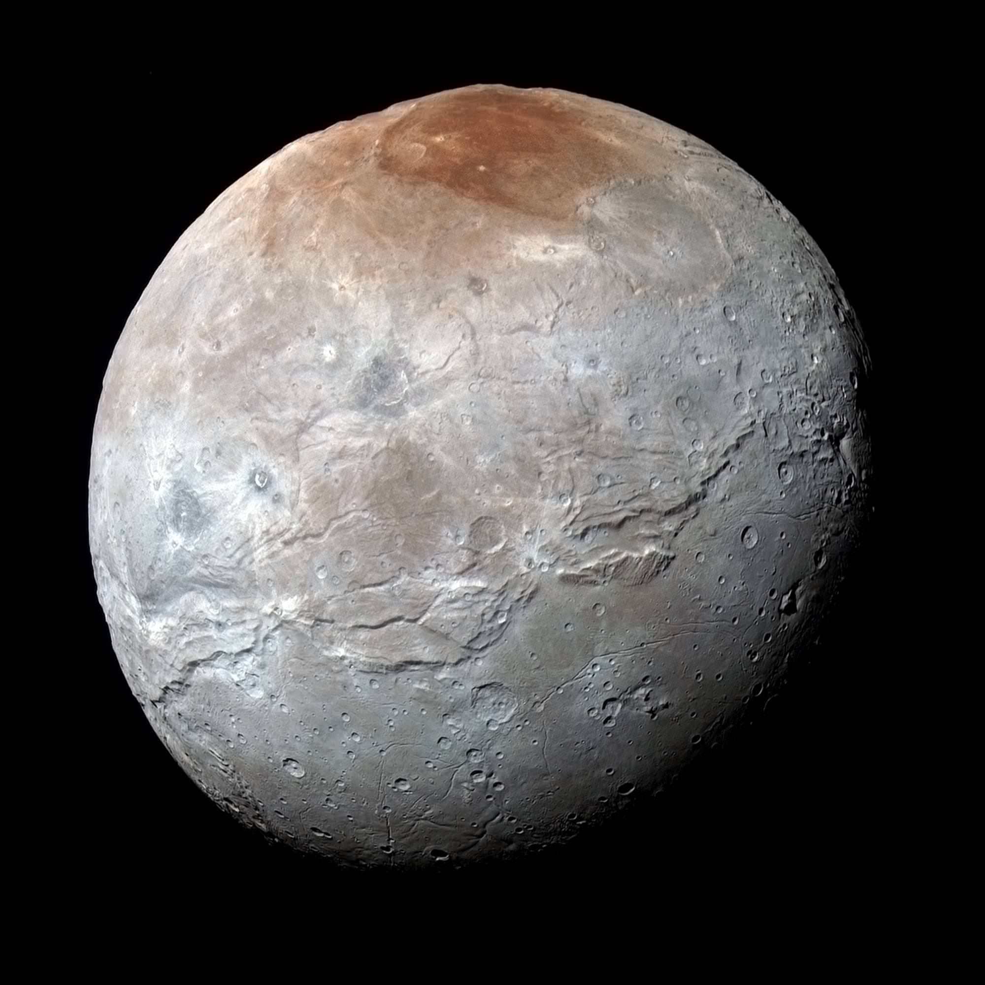
Charon in Enhanced Color with Grand Canyon
NASA’s New Horizons captured this high-resolution enhanced color view of Charon and its Grand Canyon just before closest approach on July 14, 2015. The image combines blue, red and infrared images taken by the spacecraft’s Ralph/Multispectral Visual Imaging Camera (MVIC); the colors are processed to best highlight the variation of surface properties across Charon. Charon’s color palette is not as diverse as Pluto’s; most striking is the reddish north (top) polar region, informally named Mordor Macula. Charon is 754 miles (1,214 kilometers) across; this image resolves details as small as 1.8 miles (2.9 kilometers). Credits: NASA/JHUAPL/SwRI[/caption]

Charon suffered such a surprisingly violent past of titanic upheavals that they created a humongous canyon stretching across the entire face of Pluto’s largest moon – as revealed in a fresh batch of images just returned from NASA’s New Horizons spacecraft.

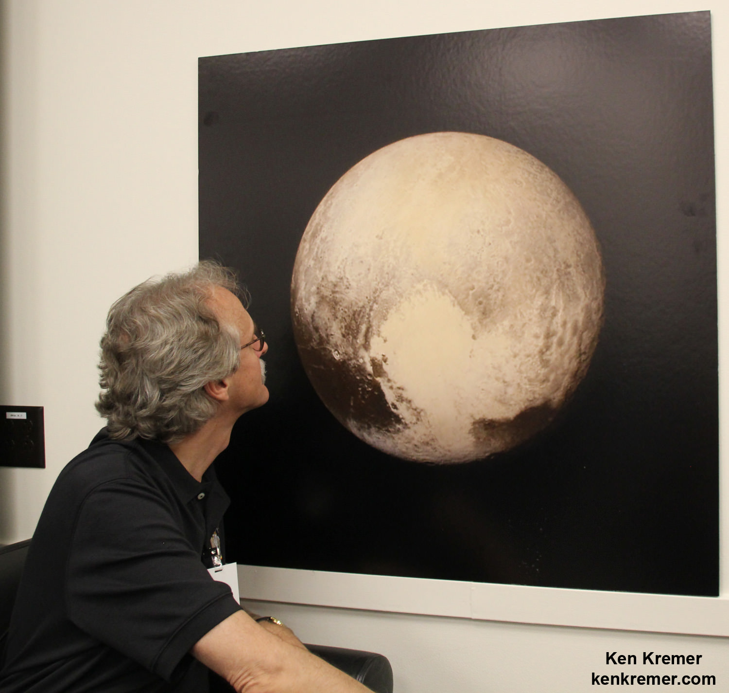
We have been agog in amazement these past few weeks as New Horizons focused its attention on transmitting astounding high resolution imagery and data of Pluto, captured during mankind’s history making first encounter with our solar systems last unexplored planet on July 14, 2015, at a distance of 7,750 miles (12,500 kilometers).

Now after tantalizing hints we see that Charon, Pluto’s largest moon, did
not disappoint and is no less exciting than the “snakeskin texture mountains” of Pluto revealed only last week.

“You’ll love this,” said New Horizons Principal Investigator Alan Stern of the Southwest Research Institute, Boulder, Colorado, in a blog posting.

Indeed researches say Charon’s tortured landscape of otherworldly canyons, mountains and more far exceeds scientists preconceived notions of a “monotonous, crater-battered world; instead, they’re finding a landscape covered with mountains, canyons, landslides, surface-color variations and more.”

“We thought the probability of seeing such interesting features on this satellite of a world at the far edge of our solar system was low,” said Ross Beyer, an affiliate of the New Horizons Geology, Geophysics and Imaging (GGI) team from the SETI Institute and NASA Ames Research Center in Mountain View, California, in a statement.

“But I couldn’t be more delighted with what we see.”

Measuring 754 miles (1,214 kilometers) across, Charon is half the diameter of Pluto and forms a double planet system. Charon also ranks as the largest satellite relative to its planet in the solar system. By comparison, Earth’s moon is one quarter the size of our home planet.

The new images of the Pluto-facing hemisphere of Charon were taken by New Horizons’ Long Range Reconnaissance Imager (LORRI) and the Ralph/Multispectral Visual Imaging Camera (MVIC) during the July 14 flyby and downlinked over about the past week and a half.

They reveal details of a belt of fractures and canyons just north of the moon’s equator.

High-resolution images of Charon were taken by the Long Range Reconnaissance Imager on NASA’s New Horizons spacecraft, shortly before closest approach on July 14, 2015, and overlaid with enhanced color from the Ralph/Multispectral Visual Imaging Camera (MVIC). Charon’s cratered uplands at the top are broken by series of canyons, and replaced on the bottom by the rolling plains of the informally named Vulcan Planum. The scene covers Charon’s width of 754 miles (1,214 kilometers) and resolves details as small as 0.5 miles (0.8 kilometers).  Credits: NASA/JHUAPL/SwRI
High-resolution images of Charon were taken by the Long Range Reconnaissance Imager on NASA’s New Horizons spacecraft, shortly before closest approach on July 14, 2015, and overlaid with enhanced color from the Ralph/Multispectral Visual Imaging Camera (MVIC). Charon’s cratered uplands at the top are broken by series of canyons, and replaced on the bottom by the rolling plains of the informally named Vulcan Planum. The scene covers Charon’s width of 754 miles (1,214 kilometers) and resolves details as small as 0.5 miles (0.8 kilometers). Credits: NASA/JHUAPL/SwRI

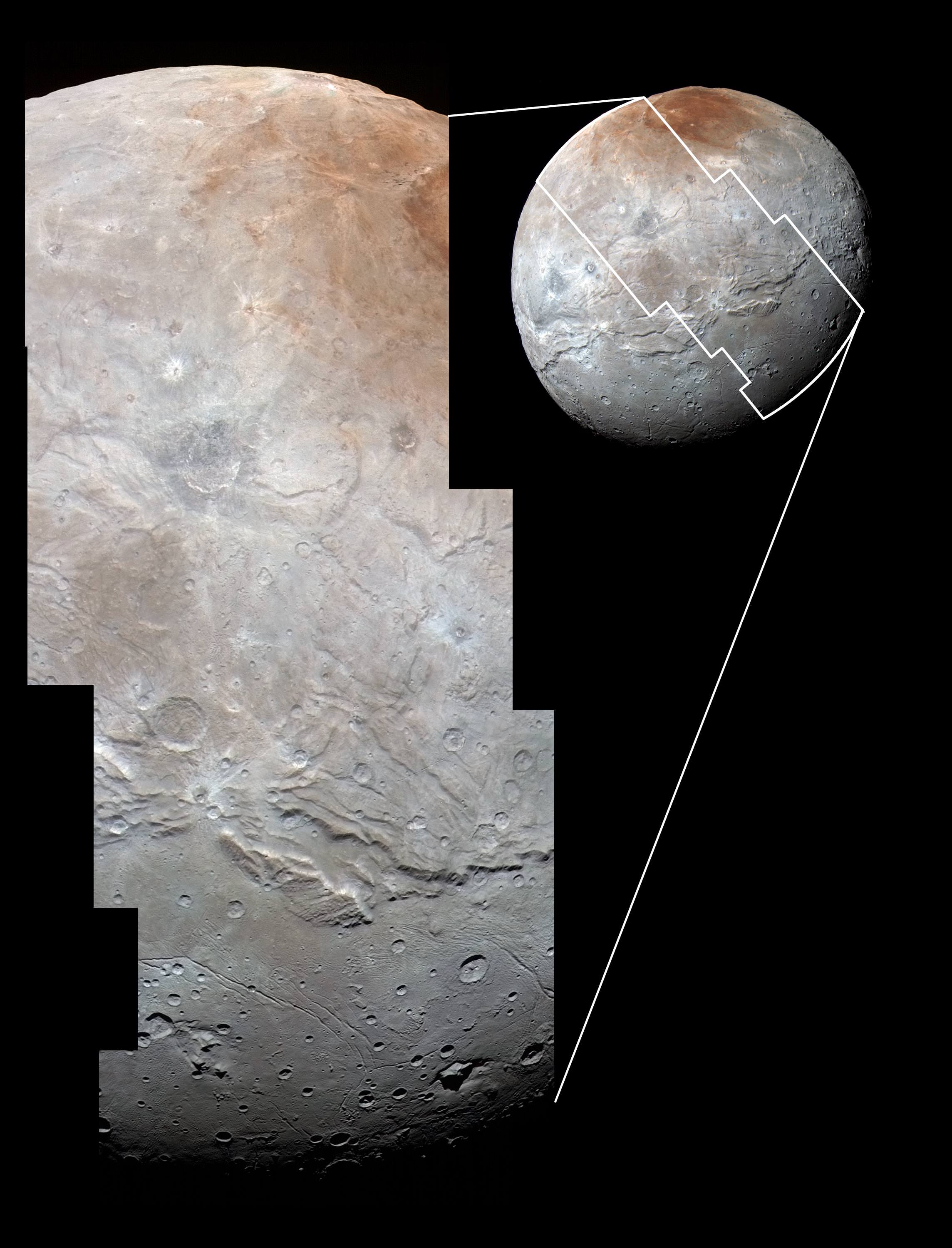
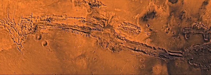
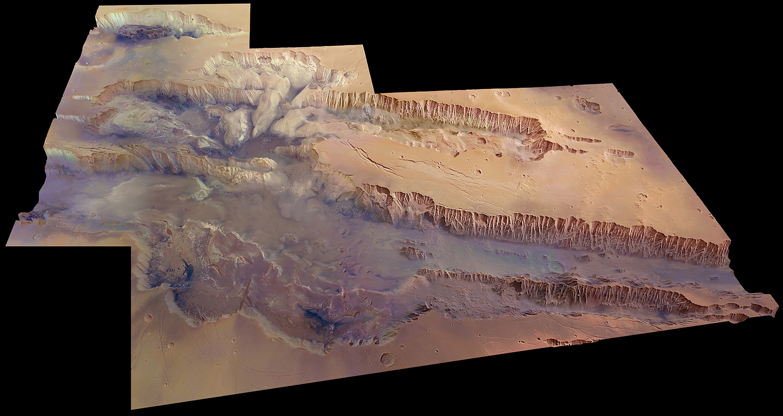
The “Grand Canyon of Charon” stretches more than 1,000 miles (1,600 kilometers) across the entire face of Charon visible in the new images. Furthermore the deep canyon probably extends onto the far side of Pluto and hearkens back to Valles Marineris on Mars.

“It looks like the entire crust of Charon has been split open,” said John Spencer, deputy lead for GGI at the Southwest Research Institute in Boulder, Colorado, in a statement.

“With respect to its size relative to Charon, this feature is much like the vast Valles Marineris canyon system on Mars.”

Charon’s “Grand Canyon” is four times as long as the Grand Canyon of the United States. Plus its twice as deep in places. “These faults and canyons indicate a titanic geological upheaval in Charon’s past,” according to the New Horizons team.

This composite of enhanced color images of Pluto (lower right) and Charon (upper left), was taken by NASA’s New Horizons spacecraft as it passed through the Pluto system on July 14, 2015. This image highlights the striking differences between Pluto and Charon. The color and brightness of both Pluto and Charon have been processed identically to allow direct comparison of their surface properties, and to highlight the similarity between Charon’s polar red terrain and Pluto’s equatorial red terrain. Pluto and Charon are shown with approximately correct relative sizes, but their true separation is not to scale. The image combines blue, red and infrared images taken by the spacecraft’s Ralph/Multispectral Visual Imaging Camera (MVIC).  Credits: NASA/JHUAPL/SwRI
This composite of enhanced color images of Pluto (lower right) and Charon (upper left), was taken by NASA’s New Horizons spacecraft as it passed through the Pluto system on July 14, 2015. This image highlights the striking differences between Pluto and Charon. The color and brightness of both Pluto and Charon have been processed identically to allow direct comparison of their surface properties, and to highlight the similarity between Charon’s polar red terrain and Pluto’s equatorial red terrain. Pluto and Charon are shown with approximately correct relative sizes, but their true separation is not to scale. The image combines blue, red and infrared images taken by the spacecraft’s Ralph/Multispectral Visual Imaging Camera (MVIC). Credits: NASA/JHUAPL/SwRI

Another intriguing finding is the area south of the canyon is much smoother, with fewer craters and may have been resurfaced by a type of “cryovolcanism.”

The southern plains are informally named “Vulcan Planum” and may be much younger.

“The team is discussing the possibility that an internal water ocean could have frozen long ago, and the resulting volume change could have led to Charon cracking open, allowing water-based lavas to reach the surface at that time,” said Paul Schenk, a New Horizons team member from the Lunar and Planetary Institute in Houston.

The piano shaped probe gathered about 50 gigabits of data as it hurtled past Pluto, its largest moon Charon and four smaller moons.

Barely 5 or 6 percent of the 50 gigabits of data captured by New Horizons has been received by ground stations back on Earth due to the slow downlink rate.

Stern says it will take about a year for all the data to get back. Many astounding discoveries await.

“I predict Charon’s story will become even more amazing!” said mission Project Scientist Hal Weaver, of the Johns Hopkins University Applied Physics Laboratory in Laurel, Maryland.

New Horizons science team co-investigator John Spencer examines print of the newest Pluto image taken on July 13, 2015 after the successful Pluto flyby. Credit: Ken Kremer/kenkremer.com

Stay tuned here for Ken’s continuing Earth and planetary science and human spaceflight news.

Ken Kremer

This new global mosaic view of Pluto was created from the latest high-resolution images to be downlinked from NASA’s New Horizons spacecraft and released on Sept. 11, 2015.   The images were taken as New Horizons flew past Pluto on July 14, 2015, from a distance of 50,000 miles (80,000 kilometers).  This new mosaic was stitched from over two dozen raw images captured by the LORRI imager and colorized.  Annotated with informal place names.  Credits: NASA/Johns Hopkins University Applied Physics Laboratory/Southwest Research Institute/Marco Di Lorenzo/Ken Kremer/kenkremer.com
This new global mosaic view of Pluto was created from the latest high-resolution images to be downlinked from NASA’s New Horizons spacecraft and released on Sept. 11, 2015. The images were taken as New Horizons flew past Pluto on July 14, 2015, from a distance of 50,000 miles (80,000 kilometers). This new mosaic was stitched from over two dozen raw images captured by the LORRI imager and colorized. Annotated with informal place names. Credits: NASA/Johns Hopkins University Applied Physics Laboratory/Southwest Research Institute/Marco Di Lorenzo/Ken Kremer/kenkremer.com

What Does the Grand Canyon Look Like from Space?

Image of the Grand Canyon from the International Space Station on March 26, 2014. Credit: NASA/JAXA Koichi Wakata.

Can you spot the Grand Canyon in this picture? It is surprisingly hard to see. Astronaut Koichi Wakata took this picture on March 26, 2014 from the International Space Station, and thankfully he provided a clue: look in the bottom center portion in the photo.

Astronaut Karen Nyberg also took a photo of the Grand Canyon last fall from the ISS, and this one offers a little better closeup:

If you’ve ever stood at this Canyon’s edge or even flew over in a plane, you know how dramatic the view is. From space … not so much.

You may have seen a fake image of the Grand Canyon from space floating around the various social medias last year that looks much more majestic. I won’t share it here, but suffice to say, it’s a doctored up aerial view with a starry sky photoshopped in. The images here are the real view of the Grand Canyon from space.

Earth’s Grand Canyon pales in comparison to Valles Marineris on Mars– the biggest canyon we know of in the Solar System — which is ten times longer and five times deeper than our Grand Canyon here on Earth.

In depth: Valles Marineris: The Grandest Canyon of All

Valles Marineris as seen in this mosaic of Viking orbiter images. Noctis Labyrinthus at the left, Melas Chasma in the middle, Hebes Chasma just left of top center, Eos Chasma at lower right and Ganges Chasma just above center right. Credit: NASA/JPL

Valles Marineris: The Grandest Canyon of All

A digital terrain model of a portion of Mars’ Valles Marineris, the largest canyon in the Solar System. Credit: ESA/DLR/FU Berlin (G. Neukum)

Anyone who’s visited the Grand Canyon in Arizona can attest to its beauty, magnificence and sheer sense of awe that comes upon approaching its rim, whether for the first time or hundred-and-first. “Grand” almost seems too inferior a title for such an enormous geological feature — yet there’s a canyon much, much bigger stretching across the surface of Mars, one that could easily swallow all of our Grand Canyon within one of its side gullies.

The image above, released online for the first time today by ESA, is a digital terrain model of a portion of Mars’ Valles Marineris: our Solar System’s grandest canyon.
It’s easy to fall into hyperbole when describing Valles Marineris. Named for NASA’s Mariner 9 spacecraft, which became the first spacecraft to orbit Mars on November 14, 1971, the canyon is over 4000 km long, 200 km wide, and 10 km deep (2,480 x 125 x 6 miles) — that’s five times deeper than the Grand Canyon and long enough to stretch across the entire contiguous United States! It’s a rift unparalleled on any other world in the Solar System.

Valles Marineris is thought to be the result of the formation of the nearby Tharsis volcanic region, home to Olympus Mons, the Solar System’s largest volcano. As the region swelled with magma billions of years ago the planet’s crust stretched and split, collapsing into a vast, deep canyon.

Much later, landslides and flowing water would help erode the canyon’s steep walls and carve out meandering side channels.

The 45-degree view above was was made from data acquired during 20 individual orbits of ESA’s Mars Express. It is presented in near-true color with four times vertical exaggeration (to increase relief contrast.) Download a high-res JPEG version here.

The largest portion of the canyon seen crossing left to right is known as Melas Chasma. Candor Chasma is the connecting trough to the north, and Hebes Chasma is in the far top left.

Below is a video released by JPL in 2006 showing a virtual fly-through of Valles Marineris, shown as if you were on a Grand Canyon-style helicopter sightseeing tour (that is, if helicopters could even work in the thin Martian air!)

Hopefully someday we’ll be seeing actual videos taken above Valles Marineris and photos captured from its rim… perhaps even by human explorers! (Please exit through the gift shop.)

Image source: ESA. Video by Eric M. De Jong and Phil Christiansen et. al, Arizona State University.