The “Potsdam Gravity Potato” Shows Variations in Earth’s Gravity

The Geoid 2011 model, based on data from LAGEOS, GRACE, GOCE and surface data. Credit: GFZ

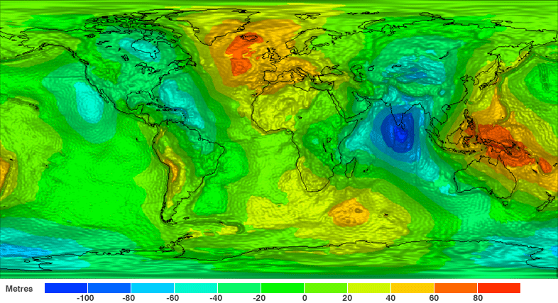
People tend to think of gravity here on Earth as a uniform and consistent thing. Stand anywhere on the globe, at any time of year, and you’ll feel the same downward pull of a single G. But in fact, Earth’s gravitational field is subject to variations that occur over time. This is due to a combination of factors, such as the uneven distributions of mass in the oceans, continents, and deep interior, as well as climate-related variables like the water balance of continents, and the melting or growing of glaciers.

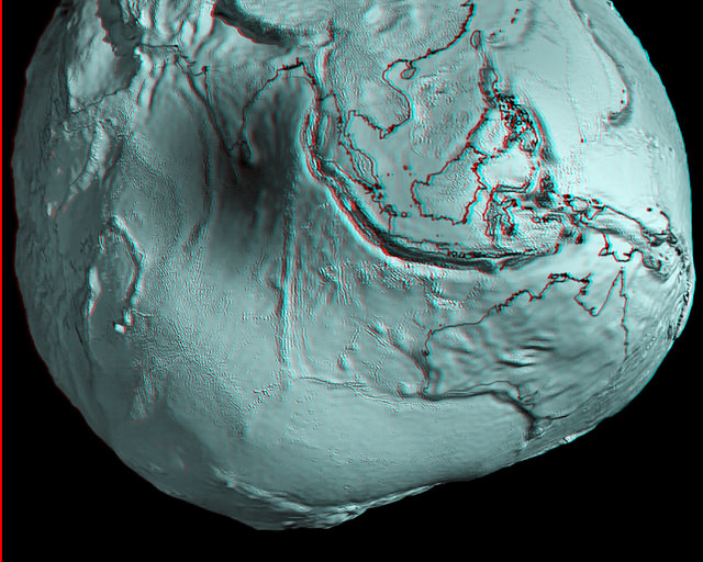
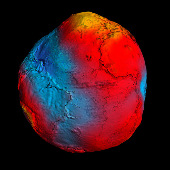
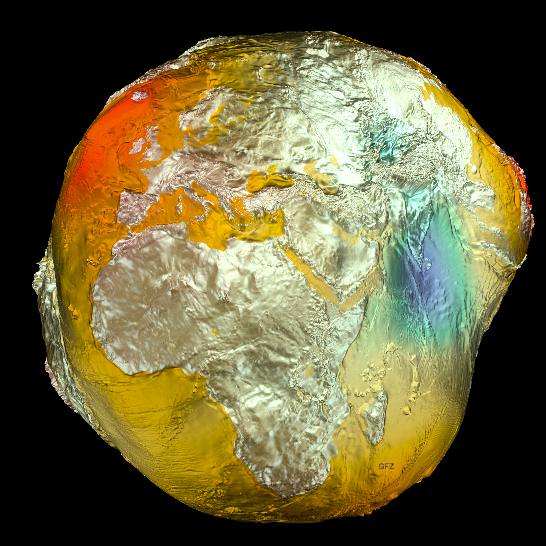
And now, for the first time ever, these variations have been captured in the image known as the “Potsdam Gravity Potato” –  a visualization of the Earth’s gravity field model produced by the German Research Center for Geophysics’ (GFZ) Helmholtz’s Center in Potsdam, Germany.

And as you can see from the image above, it bears a striking resemblance to a potato. But what is more striking is the fact that through these models, the Earth’s gravitational field is depicted not as a solid body, but as a dynamic surface that varies over time.This new gravity field model (which is designated EIGEN-6C) was made using measurements obtained from the LAGEOS, GRACE, and GOCE satellites, as well as ground-based gravity measurements and data from the satellite altimetry.

The Geoid 2005 model, which was based on data of two satellites (CHAMP and GRACE) plus surface data. Credit: GFZ
The 2005 model, which was based on data from the CHAMP and GRACE satellites and surface data, was less refined than the latest one. Credit: GFZ

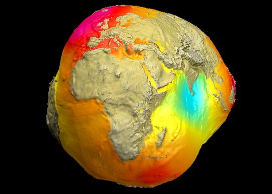
Compared to the previous model obtained in 2005 (shown above), EIGEN-6C has a fourfold increase in spatial resolution.

“Of particular importance is the inclusion of measurements from the satellite GOCE, from which the GFZ did its own calculation of the gravitational field,” says Dr. Christoph Foerste who directs the gravity field work group at GFZ along with Dr. Frank Flechtner.

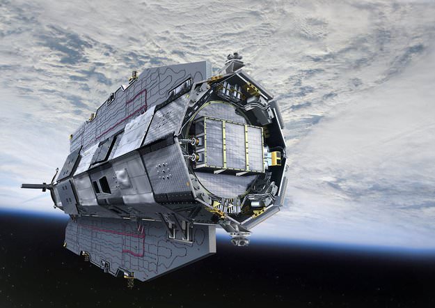
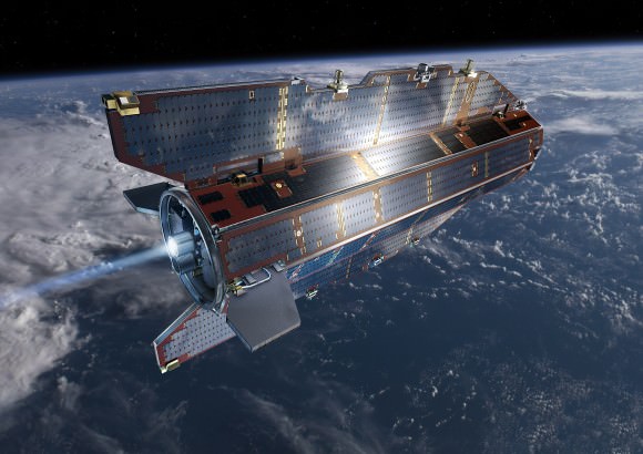
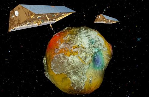
The ESA mission GOCE (Gravity Field and Steady-State Ocean Circulation Explorer) was launched in mid-March 2009 and has since been measuring the Earth’s gravitational field using satellite gradiometry – the study and measurement of variations in the acceleration due to gravity.

“This allows the measurement of gravity in inaccessible regions with unprecedented accuracy, for example in Central Africa and the Himalayas,” said Dr. Flechtner. In addition, the GOCE satellites offers advantages when it comes to measuring the oceans.

Within the many open spaces that lie under the sea, the Earth’s gravity field shows variations. GOCE is able to better map these, as well as deviations in the ocean’s surface – a factor known as “dynamic ocean topography” – which is a result of Earth’s gravity affecting the ocean’s surface equilibrium.

Twin-satellites GRACE with the earth's gravity field (vertically enhanceded) calculated from CHAMP data. Credit: GFZ
Twin-satellites GRACE with the earth’s gravity field (vertically enhanced) calculated from CHAMP data. Credit: GFZ

Long-term measurement data from the GFZ’s twin-satellite mission GRACE (Gravity Recovery And Climate Experiment) were also included in the model. By monitoring climate-based variables like the melting of large glaciers in the polar regions and the amount of seasonal water stored in large river systems, GRACE was able to determine the influence of large-scale temporal changes on the gravitational field.

Given the temporal nature of climate-related processes – not to mention the role played by Climate Change – ongoing missions are needed to see how they effect our planet long-term. Especially since the GRACE mission is scheduled to end in 2015.

In total, some 800 million observations went into the computation of the final model which is composed of more than 75,000 parameters representing the global gravitational field. The GOCE satellite alone made 27,000 orbits during its period of service (between March 2009 and November 2013) in order to collect data on the variations in the Earth’s gravitational field.

The final result achieved centimeter accuracy, and can serve as a global reference for sea levels and heights. Beyond the “gravity community,” the research has also piqued the interest of researchers in aerospace engineering, atmospheric sciences, and space debris.

But above all else, it offers scientists a way of imaging the world that is different from, but still complimentary to, approaches based on light, magnetism, and seismic waves. And it could be used for everything from determining the speed of ocean currents from space, monitoring rising sea levels and melting ice sheets, to uncovering hidden features of continental geology and even peeking at the convection force driving plate tectonics.

Further Reading: GFZ

GOCE Satellite Plunges Back to Earth Without Incident

Artist rendition of the GOCE Satellite in orbit. Credit: ESA

ESA’s GOCE satellite has reentered Earth’s atmosphere, with most of the spacecraft disintegrating high in the atmosphere. There have been no reports of damage to property or sightings of debris. Astrophysicist and satellite watcher Jonathan McDowell reported that the spacecraft came down at approximately 00:16 UTC on November 11, 2013 over the South Atlantic Ocean east of Tierra del Fuego – an archipelago off the southernmost tip of the South America.

The last visible sighting of GOCE was at 22:42 UTC on Nov. 10 as it passed 121km (75 miles) above Antarctica, BBC reported.

While most of the 1100 kg satellite disintegrated in the atmosphere, an estimated 25% reached Earth’s surface, likely falling in the ocean.

“The one-ton GOCE satellite is only a small fraction of the 100–150 tons of man-made space objects that reenter Earth’s atmosphere annually,” said Heiner Klinkrad, Head of ESA’s Space Debris Office. “In the 56 years of spaceflight, some 15,000 tons of man-made space objects have reentered the atmosphere without causing a single human injury to date.”

The GOCE spacecraft was designed to fly low and has spent most of its mission roughly 500 km below most other Earth-observing missions, at an altitude of 255 km (158 miles), but has recently been at the lowest altitude of any research satellite at 224 km (139 miles).

Its durable construction and sleek design allowed it to stay in space for longer than expected; it nearly tripled its planned lifetime.

With GOCE data, scientists created the first global high-resolution map of the boundary between Earth’s crust and mantle – called the Moho – and to detect sound waves from the massive earthquake that hit Japan on 11 March 2011, among other results.

Read more about GOCE at ESA.

GOCE Spacecraft Will Likely Make Uncontrolled Re-entry This Weekend

Artist rendition of the GOCE Satellite in orbit. Credit: ESA

The Gravity field and steady-state Ocean Circulation Explorer (GOCE) satellite has been orbiting Earth in super-low orbits since 2009, mapping out variations in Earth’s gravity in extreme detail. But its fuel ran out in mid-October and the satellite began its slow descent towards Earth, being brought lower and lower by the effects of the atmosphere. Engineers predict it will re-enter completely and fall back to Earth sometime this weekend.

But no one can say for sure when or where the 1-ton satellite will fall.

With no remaining fuel to guide its re-entry there’s no way to nudge or steer its descent. And while most of GOCE is predicted to disintegrate in the atmosphere, several parts might reach Earth’s surface. Experts predict as much as 25% of the spacecraft will survive reentry, as many parts are made of advanced materials, such as carbon-carbon composites.

Today, engineers from the GOCE mission said that the spacecraft is predicted to enter into Earth’s atmosphere sometime during the night between Sunday and Monday, November 10-11, 2013. Break-up of the spacecraft will occur at an altitude of approximately 80 km. “At the moment, the exact time and location of where the fragments will land cannot be foreseen,” says ESA.

The GOCE spacecraft was designed to fly low and has spent most of its mission roughly 500 km below most other Earth-observing missions, at an altitude of 255 km (158 miles), but has recently been at the lowest altitude of any research satellite at 224 km (139 miles).

Its durable construction and sleek design allowed it to stay in space for longer than expected; it nearly tripled its planned lifetime.

With GOCE data, scientists created the first global high-resolution map of the boundary between Earth’s crust and mantle – called the Moho – and to detect sound waves from the massive earthquake that hit Japan on 11 March 2011, among other results.

Heiner Klinkrad, Head of ESA’s Space Debris Office at ESOC, Darmstadt, Germany said that when the spacecraft reaches altitudes below 100 km, then atmospheric density will drastically increase on the spacecraft. It will enter at about 25,000 km/hour, and aerodynamic pressure and heating will cause a break-up of the spacecraft at approximately 80km altitude, causing a large number of fragments.

“The risk to the population on ground will be minute,” said Klinkrad. “Statistically speaking, it is 250,000 times more probable to win the jackpot in the German Lotto than to get hit by a GOCE fragment. In 56 years of space flight, no man-made space objects that have re-entered into Earth’s atmosphere have ever caused injury to humans.”

An international campaign will be monitoring the descent, involving the Inter-Agency Space Debris Coordination Committee. The situation is being continuously watched by ESA’s Space Debris Office, which will issue re-entry predictions and risk assessments.

ESA says they will keep the relevant safety authorities permanently updated.

Sources: ESA, ESA Blog

Sleek GOCE Spacecraft Will Have Uncontrolled Re-entry into Earth’s Atmosphere

GOCE in orbit. Credit: ESA

The sleek and sexy-looking GOCE spacecraft has been mapping Earth’s gravity for over four years, but soon its xenon fuel will run out and the satellite will end up re-entering our atmosphere. But no one can say for sure when or where the 1-ton satellite will fall.

The Gravity field and steady-state Ocean Circulation Explorer has been orbiting Earth at super-low orbits, mapping out variations in Earth’s gravity with extreme detail. Launched in March 2009, the GOCE spacecraft was designed to fly low and has spent most of its mission roughly 500 km below most other Earth-observing missions, at an altitude of 255 km (158 miles), but has recently been at the lowest altitude of any research satellite at 224 km (139 miles).

With its sleek, aerodynamic design, some have called it the ‘Ferrari of space,’ but we’ve just called it sexy, like a satellite straight out of a James Bond movie.

And the satellite has delivered with unique results of Earth’s ‘geoid’ — precise measurements of ocean circulation, sea-level change and ice dynamics, greatly improving our knowledge and understanding of the Earth’s internal structure. The mission has also been studying air density and wind in space. Its data also produced the first global high-resolution map of the boundary between Earth’s crust and mantle, called the Mohorovicic, or “Moho” discontinuity.

Mission managers predict that in mid-October 2013 the spacecraft will run out of fuel and the satellite will begin its descent towards Earth. There will be no remaining fuel to guide its re-entry, and while most of GOCE is predicted to disintegrate in the atmosphere, several parts might reach Earth’s surface. Experts predict as much as 25% of the spacecraft will survive reentry, as many parts are made of advanced materials, such as carbon-carbon composites.

But when and where these parts might land cannot yet be predicted, ESA says.

As the re-entry time nears, better predictions will be made. Re-entry is expected to happen about three weeks after the fuel is depleted.

ESA says that taking into account that two thirds of Earth are covered by oceans and vast areas are thinly populated, the danger to life or property is very low.

Recently, other larger satellites have made uncontrolled re-entries, such as NASA’s 6-ton UARS spacecraft and Germany’s 2.4-ton ROSAT in 2011 and the 13-ton failed Russian Mars probe, Phobos-Grunt in 2012.

About 40 tons of human-made space debris reach the ground per year, but the spread and size mean the risk of an individual being struck is lower than being hit by a meteorite.

An international campaign will be monitoring the descent, involving the Inter-Agency Space Debris Coordination Committee. The situation is being continuously watched by ESA’s Space Debris Office, which will issue re-entry predictions and risk assessments.

ESA says they will keep the relevant safety authorities permanently updated.

Additional info: ESA, BBC

GOCE Data Close Up: Around the World in Lumpy, Geoidy 3-D

Australia and Asia region of Earth's geoid. Credits: ESA/HPF/DLR, anaglyph by Nathanial Burton-Bradford.

[/caption]

Grab your red/cyan 3-D glasses and take a look at these marvelous new anaglyphs created by Nathanial Burton-Bradford from the latest data from GOCE satellite, showing Earth’s gravity field – or geoid. The geoid is essentially a map of the shape our world would be its surface were covered by water and if gravity were the only thing shaping this global ocean’s surface. These exaggerated views (the surface in the images of the geoid is amplified by a factor 7,000) show the most accurate model of how gravity varies across the planet. Nathanial was able to obtain high-resolution video from Dr. Rune Floberghagen of the GOCE team from which he extracted appropriate frames in order to construct hi-res anaglyph images of numerous longitudes across the globe.

In our previous article about GOCE (Gravity Field and Steady-State Ocean Circulation Explorer), we showed the entire globe and how it looks like a spinning potato. Nathanial’s anaglyphs show close-ups of various parts of the globe. Above is Australia and Asia. Take a trip around the GOCE geoid 3-D world below. Remember, use the red/cyan 3-D glasses to get the full effect!


GOCE view of South America. Credits: ESA/HPF/DLR, anaglyph by Nathanial Burton-Bradford.

GOCE view of the US and Mexico. Credits: ESA/HPF/DLR, anaglyph by Nathanial Burton-Bradford.
GOCE view of Europe. Credits: ESA/HPF/DLR, anaglyph by Nathanial Burton-Bradford.
GOCE view of Africa.. Credits: ESA/HPF/DLR, anaglyph by Nathanial Burton-Bradford.
GOCE global view, 145 East Longitude. Credits: ESA/HPF/DLR, anaglyph by Nathanial Burton-Bradford.
GOCE global view, 140 West Longitude. Credits: ESA/HPF/DLR, anaglyph by Nathanial Burton-Bradford.

Thanks to Nathanial Burton-Bradford for sharing his images. See more at his Flickr page.

New Results from GOCE: Earth is a Rotating Potato

In this GOCE image, gravity is strongest in yellow areas; it is weakest in blue ones. Credit: ESA

Although they aren’t particularly fond of the comparison, scientists from the GOCE satellite team had to admit that new data showing Earth’s gravity field – or geoid — makes our planet look like a rotating potato. After just two years in orbit, ESA’s sleek and sexy GOCE satellite (Gravity Field and Steady-State Ocean Circulation Explorer) has gathered sufficient data to map Earth’s gravity with unrivalled precision. While our world certainly doesn’t look like a spinning tuber, this exaggerated view shows the most accurate model of how gravity varies across the planet.

The geoid is nothing more than how the oceans would vary if there were no other forces besides gravity acting on our planet.

“If we had an homogeneous sphere, it would be a boring sphere,” said GOCE scientist Roland Pail from Technical University in Munich, speaking at the press briefing today. “But due to rotation, you get a flattening of the Earth, and we have topography such as mountains, and irregular mass distribution in Earth’s interior. What we are showing you here, in principle, is the gravity field by any deviations due to inhomogeneous mass distributions on the Earth and the Earth’s interior.”

[/caption]

While a previous gravity satellite, the Gravity Recovery And Climate Experiment (GRACE) operated for 8 years, most of the new data from GOCE was gathered in about 14 months, and provides data where there was none before.

GOCE is able to sense tiny variations in the pull of gravity over Earth, and the data is used to construct an idealized surface, which traces gravity lumps and bumps, and is the shape the oceans would take without winds, currents, Earth’s rotation and other forces.

By comparing sea level and geoid data, GOCE is revealing data on ocean currents and circulation, sea-level change, ice dynamics, said Rory Bingham, from the University of Newcastle, which helps understand heat transport and the changing climate.

But also of interest is how GOCE data reveals shifting tectonic plates in earthquakes and magma movements under volcanoes. Following the earthquakes in Japan, scientists are looking closely, as the data should reveal a three-dimensional view of what was going on inside the Earth. Even though the motion cannot be observed directly from space, earthquakes create signatures in gravity data, which could be used to understand the processes leading to these natural disasters and ultimately help to predict them.

“Even though these quakes resulted from big movements in the Earth, at the altitude of the satellite the signals are very small. But we should still seem them in the data,” said Dr. Johannes Bouman from the German Geodetic Research Institute.

GOCE in orbit. Credit: ESA

“GOCE will give us dynamic topography and circulation patterns of the oceans with unprecedented quality and resolution,” said professor Reiner Rummel, former Head of the Institute for Astronomical and Physical Geodesy at the Technische Universität München. “I am confident that these results will help improve our understanding of the dynamics of world oceans.”

“You could say that, at its early conception, GOCE was more like science fiction,” said Volker Liebig, Director of ESA’s Earth Observation Program. “GOCE has now clearly demonstrated that it is a state-of-the-art mission.”

Sources: GOCE press briefing, ESA press release

Earth’s Gravity Seen in HD

New map of Earth's gravity field from GOCE. Credit: ESA

[/caption]

The sleek and sexy-looking GOCE satellite has provided a new, finely detailed look at Earth’s gravity – in high definition. This is the first-ever global gravity model and is based on just two months of data from the low-flying GOCE. “GOCE is delivering where it promised: in the fine spatial scales,” GOCE Mission Manager Rune Floberghagen said. “We have already been able to identify significant improvements in the high-resolution ‘geoid’, and the gravity model will improve as more data become available.”

GOCE stands for Gravity field and steady-state Ocean Circulation Explorer.

The geoid is a measure of the lumps and bumps in Earth’s gravity, and shows how the surface would look if an ocean covered the earth, also known as surface of equal gravitational attraction and mean sea level.
Scientists say it is a crucial reference for accurately measuring ocean circulation, sea-level change and ice dynamics – all affected by climate change.

GOCE in orbit. Credit: ESA

The GOCE team presented their initial data at ESA’s Living Planet Symposium. ESA launched GOCE in March 2009, and the data is from November and December 2009.

“Over continents, and in particular in regions poorly mapped with terrestrial or airborne techniques, we can already conclude that GOCE is changing our understanding of the gravity field,” said Floberghagen. Over major parts of the oceans, the situation is even clearer, as the marine gravity field at high spatial resolution is for the first time independently determined by an instrument of such quality.”

This will greatly improve our knowledge and understanding of the Earth’s internal structure, and will be used as a much-improved reference for ocean and climate studies, including sea-level changes, oceanic circulation and ice caps dynamics survey. Numerous applications are expected in climatology, oceanography and geophysics.

“The computed global gravity field looks very promising. We can already see that important new information will be obtained for large areas of South America, Africa, Himalaya, South-East Asia and Antarctica,” said Prof. Reiner Rummel from Technische Universität München, Chairman of the GOCE Mission Advisory Group. “With each two-month cycle of data, the gravity model will become more detailed and accurate. I am convinced that the data will be of great interest to various disciplines of Earth sciences.”

The spacecraft can measure accelerations as small as 1 part in 10,000,000,000,000 of the gravity experienced on Earth.

GOCE flies in orbit at just 254.9 km (158 miles) mean altitude – the lowest orbit sustained over a long period by any Earth observation satellite, but the lower the altitude, the better the data.

Anaglyph images created from an ESA video animation of global gravity gradients. A more accurate global map will be generated by ESA's GOCE craft. Credit: ESA and Nathaniel Burton Bradford.

The residual air at this low altitude causes the orbit of a standard satellite to decay very rapidly. So, to counteract the drag, the satellite fires an ion thruster using xenon gas, maintaining its orbit. This ensures the gravity sensors are flying as though they are in pure freefall, so they pick up only gravity readings and not the disturbing effects from other forces.

To obtain clean gravity readings, there can be no disturbances from moving parts, so the entire satellite is a single extremely sensitive measuring device.

The new map is just from the first data, and more information will be forthcoming. In May, ESA made available the first set of gravity gradients and ‘high-low satellite-to-satellite tracking’ to scientific and non-commercial users – and much more will come in the following months.

Souces: ESA, BBC

GOCE Satellite Begins Mapping Earth’s Gravity in Lower Orbit Than Expected

Anaglyph images created from an ESA video animation of global gravity gradients. A more accurate global map will be generated by ESA's GOCE craft. Credit: ESA and Nathaniel Burton Bradford.

[/caption]
Is Earth’s gravity field as intriguing and misshapen as this image above? We’re about to find out. The sexy looking Gravity field and steady-state Ocean Circulation Explorer or GOCE satellite has completed its calibration and is now in its science orbit to map the tiny variations of Earth’s gravity in unprecedented detail. And it turns out the sun’s current period of low solar activity has a side benefit for the GOCE mission. Less solar activity means a calmer environment for GOCE in its low Earth orbit, so its current orbit of 255 km is a few kilometers lower than engineers had originally planned. This is good news – the gravity measurements being made at the moment will be even more accurate.

“The completion of the commissioning and first in-flight calibration marks an important milestone for the mission, ” said Rune Floberghagen, ESA’s GOCE Mission Manager. “We are now entering science operations and are looking forward to receiving and processing excellent three-dimensional information on the structure of Earth’s gravity field.”

Anaglyph created from an ESA GOCE craft animation. Credit:  ESA and Nathanial Burton Bradford
Anaglyph created from an ESA GOCE craft animation. Credit: ESA and Nathanial Burton Bradford

Gravity is stronger closer to Earth, so GOCE was designed to orbit as low as possible while remaining stable as it flies through the fringes of our atmosphere. GOCE’s sleek aerodynamic design helps this the satellite to cut though the tenuous fringes of Earth’s atmosphere at this low altitude. Moreover, the electric ion thruster at the back continuously generates tiny forces to compensate for any drag that GOCE experiences along its orbit.

To help avoid drag and ensure that the gravity measurements are of true gravity, the satellite has to be kept stable in ‘free fall’. Any buffeting from residual air at this low altitude could potentially drown out the gravity data.

Space gradiometry and the use of the sophisticated electric propulsion are both ‘firsts’ in satellite technology, so the commissioning and calibration were particularly important for the success of the mission. This phase was completed in the summer, ready for the tricky task of bringing GOCE down to its operational altitude, which took a couple of months.

Worldwide gravity gradients from simulations. GOCE is now gathering data such as shown here to map Earth's gravity with unprecedented accuracy and spatial resolution. Credit:  ESA
Worldwide gravity gradients from simulations. GOCE is now gathering data such as shown here to map Earth's gravity with unprecedented accuracy and spatial resolution. Credit: ESA

Over two six-month uninterrupted periods, GOCE will map these subtle variations with extreme detail and accuracy. This will result in a unique model of the ‘geoid’ – the surface of an ideal global ocean at rest.

A precise knowledge of the geoid is crucial for accurate measurement of ocean circulation and sea-level change, both of which are influenced by climate. The data from GOCE are also much-needed to understand the processes occurring inside Earth. In addition, by providing a global reference to compare heights anywhere in the world, the GOCE-derived geoid will be used for practical applications in areas such as surveying and leveling.

Stay tuned for some unique data about our home planet from GOCE.

Thanks to Nathanial Burton-Bradford for the terrific anaglyphs he created from a GOCE animation. See more of Nathanial’s images on his Flickr page.

Source: ESA