Three federal agencies — the National Park Service, the EPA and now NASA — have allegedly launched unofficial “protest” accounts on Twitter in defiance of the Trump team’s directives to not blog, tweet or talk to the news media about climate changes issues. While it’s not unusual for a new administration to want to control the message, many bristle at what they see as an administration that wants to redefine and control scientific fact.
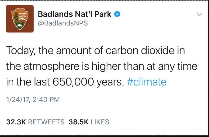
That brings us to these accounts. Are they really created by NASA and other government employees or are they the work of ticked off science advocates not connected to the agencies? In at least one case earlier this week in Badlands National Park, a former employee posted this unauthorized tweet:
“Today, the amount of carbon dioxide in the atmosphere is higher than at any time in the last 650,000 years.” The tweet was later removed.
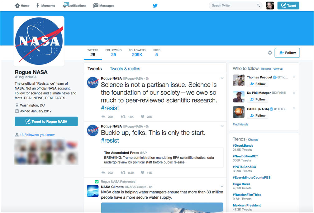
The @RogueNASA Twitter account uses NASA’s logo — a no-no unless you have specific permission. The site describes itself as “the unofficial “Resistance” team of NASA. Not an official NASA account. Follow for science and climate news and facts. REAL NEWS, REAL FACTS.”
NASA’s very strict about how it’s logo is used. Under Media Usage Guidelines, here’s what the agency has to say:
“The NASA insignia logo (the blue “meatball” insignia), the retired NASA logotype (the red “worm” logo) and the NASA seal may not be used for any purpose without explicit permission. These images may not be used by persons who are not NASA employees or on products, publications or web pages that are not NASA-sponsored. These images may not be used to imply endorsement or support of any external organization, program, effort, or persons.”
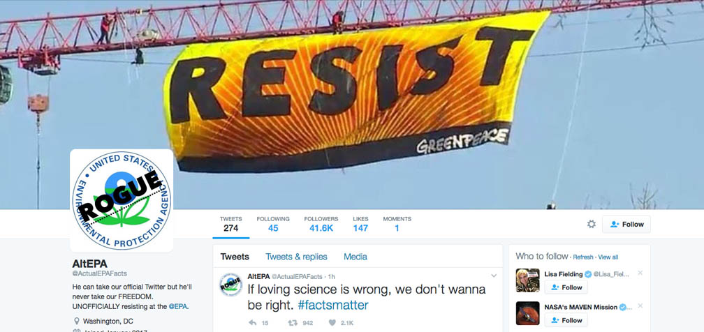
AltEPA Twitter page. Credit: Twitter
Moreover, NASA reported that it had not given permission for another group or person to use its logo on the new account. While the sites may be legit and you and I sympathetic to the cause, exercise skepticism when poking around these accounts. Be cautious of opening up or downloading files the same way you’re careful with e-mail attachments. Take a look, participate, but be wary.
For your perusal, the current “alt science” sites I’m aware of are listed below. My hunch after looking at them is that it’s possible they may have been created by the same group of people. Whatever their origin, they’re quickly becoming very popular. As of Wednesday evening (Jan. 25), Rogue NASA has 209,000 followers; AltEPA 41,600 and 883,000 at AltUSNatParkService.
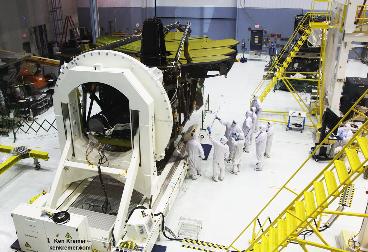
NASA engineers and technicians position the James Webb Space Telescope (inside a large tent) onto the shaker table used for vibration testing. Credits: NASA/Chris Gunn
NASA engineers and technicians position the James Webb Space Telescope (inside a large tent) onto the shaker table used for vibration testing. Credits: NASA/Chris Gunn
The vibration tests are conducted by the team on a shaker table at Goddard to ensure Webb’s worthiness and that it will survive the rough and rumbling ride experienced during the thunderous rocket launch to the heavens slated for late 2018.
“Testing on the ground is critical to proving a spacecraft is safe to launch,” said Lee Feinberg, an engineer and James Webb Space Telescope Optical Telescope Element Manager at Goddard, in a statement.
“The Webb telescope is the most dynamically complicated article of space hardware that we’ve ever tested.”
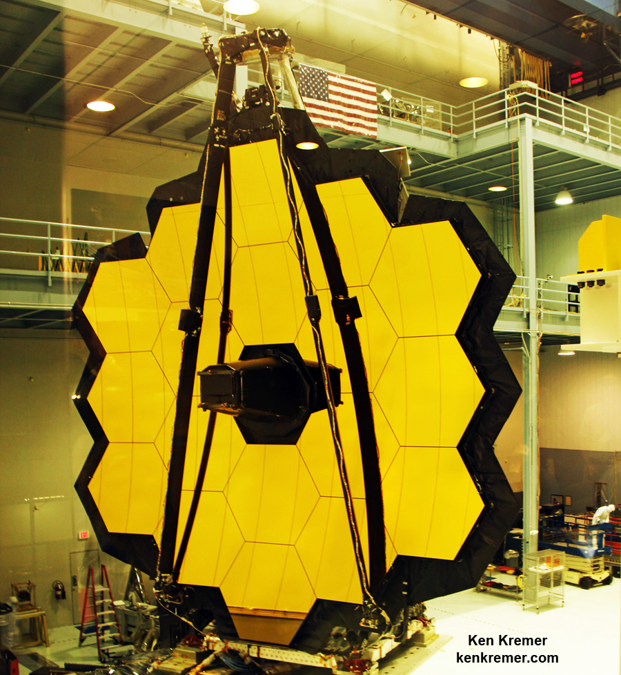
The 18-segment gold coated primary mirror of NASA’s James Webb Space Telescope is raised into vertical alignment in the largest clean room at the agency’s Goddard Space Flight Center in Greenbelt, Maryland, on Nov. 2, 2016. The secondary mirror mount booms are folded down into stowed for launch configuration. Credit: Ken Kremer/kenkremer.com
Testing of the gargantuan Webb Telescope had ground to a halt after a brief scare in early December when technicians initially detected “anomalous readings” that raised potential concerns about the observatories structural integrity partway through a preplanned series of vibration tests.
“On December 3, 2016, vibration testing automatically shut down early due to some sensor readings that exceeded predicted levels,” officials said.
Thereafter, engineers and technicians carried out a new batch of intensive inspections of the observatory’s structure during December.
Shortly before Christmas, NASA announced on Dec. 23 that JWST was deemed “sound” and apparently unscathed after engineers conducted both “visual and ultrasonic examinations” at NASA’s Goddard Space Flight Center in Maryland. Officials said the telescope was found to be safe at this point with “no visible signs of damage.”
As it turned out the culprit of the sensor anomaly was the many “tie-down … restraint mechanisms ” that hold the telescope in place.
“After a thorough investigation, the James Webb Space Telescope team at NASA Goddard determined that the cause was extremely small motions of the numerous tie-downs or “launch restraint mechanisms” that keep one of the telescope’s mirror wings folded-up for launch,” NASA officials explained in a statement.
Furthermore engineers revealingly discovered that “the ground vibration test itself is more severe than the launch vibration environment.”
Technicians work on the James Webb Space Telescope in the massive clean room at NASA’s Goddard Space Flight Center, Greenbelt, Maryland, on Nov. 2, 2016, as the completed golden primary mirror and observatory structure stands gloriously vertical on a work stand, reflecting incoming light from the area and observation deck. Credit: Ken Kremer/kenkremer.com
NASA reported today (Jan. 25) that the testing resumed last week at the point where it had been paused. Furthermore the testing was completed along the first of three axis.
“In-depth analysis of the test sensor data and detailed computer simulations confirmed that the input vibration was strong enough and the resonance of the telescope high enough at specific vibration frequencies to generate these tiny motions. Now that we understand how it happened, we have implemented changes to the test profile to prevent it from happening again,” explained Feinberg.
“We have learned valuable lessons that will be applied to the final pre-launch tests of Webb at the observatory level once it is fully assembled in 2018. Fortunately, by learning these lessons early, we’ve been able to add diagnostic tests that let us show how the ground vibration test itself is more severe than the launch vibration environment in a way that can give us confidence that the launch itself will be fully successful.”
The next step is to resume and complete shaking the telescope in the other two axis, or “two directions to show that it can withstand vibrations in all three dimensions.”
“This was a great team effort between the NASA Goddard team, Northrop Grumman, Orbital ATK, Ball Aerospace, the European Space Agency, and Arianespace,” Feinberg said. “We can now proceed with the rest of the planned tests of the telescope and instruments.”
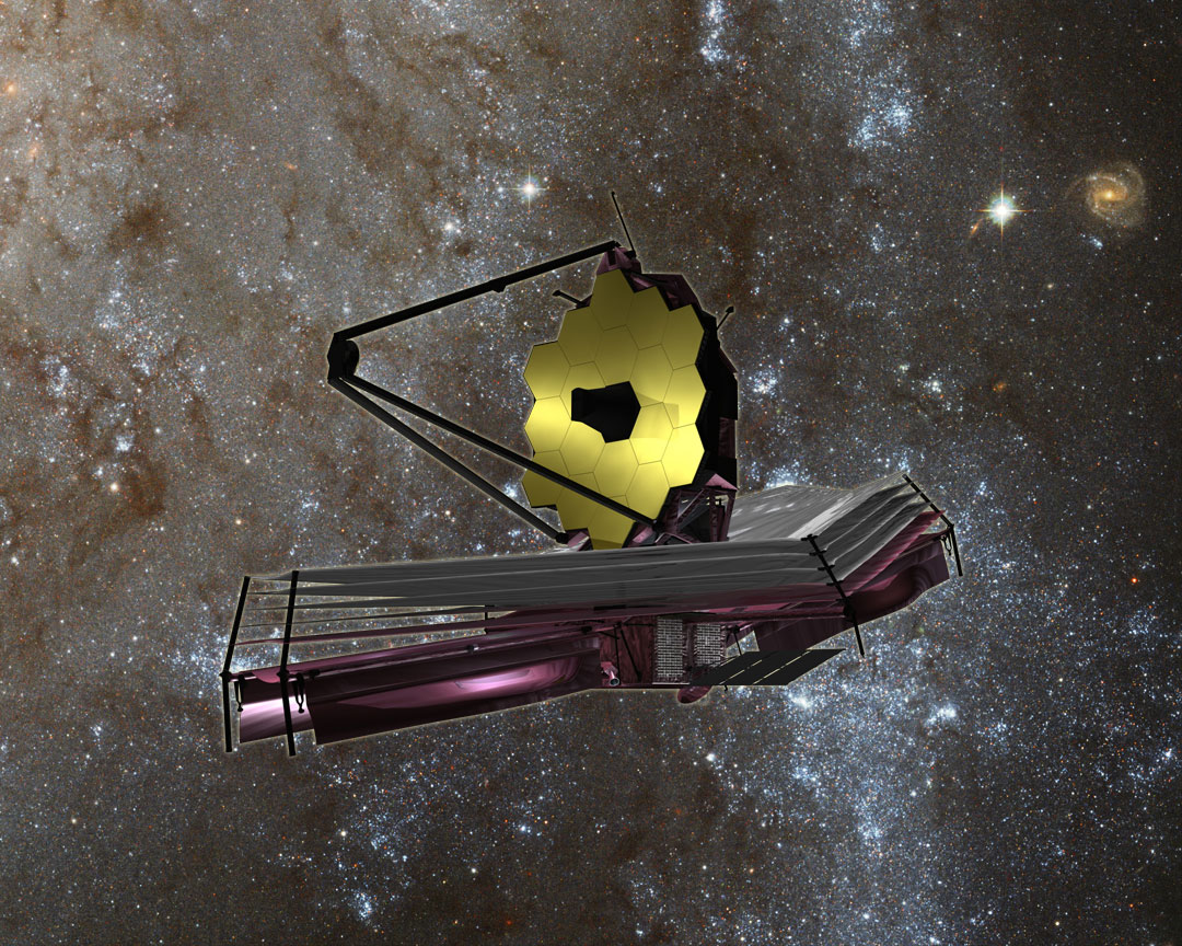
NASA’s James Webb Space Telescope is the most powerful space telescope ever built and is the scientific successor to the phenomenally successful Hubble Space Telescope (HST). The mammoth 6.5 meter diameter primary mirror has enough light gathering capability to scan back over 13.5 billion years and see the formation of the first stars and galaxies in the early universe.
The Webb telescope will launch on an ESA Ariane V booster from the Guiana Space Center in Kourou, French Guiana in 2018.
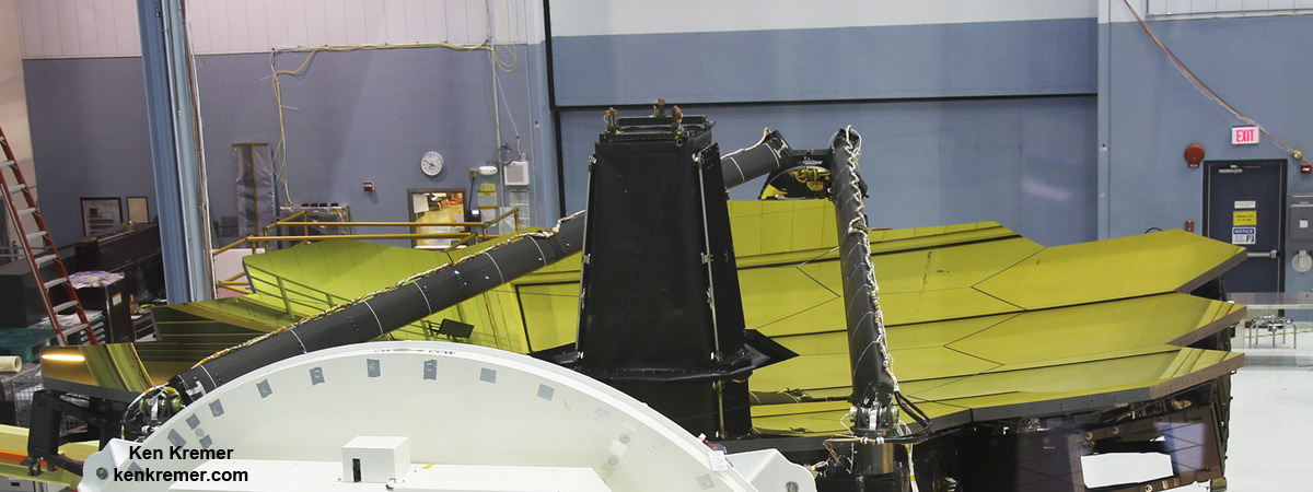
But Webb and its 18 segment “golden” primary mirror have to be carefully folded up to fit inside the nosecone of the Ariane V booster.
“Due to its immense size, Webb has to be folded-up for launch and then unfolded in space. Prior generations of telescopes relied on rigid, non-moving structures for their stability. Because our mirror is larger than the rocket fairing we needed structures folded for launch and moved once we’re out of Earth’s atmosphere. Webb is the first time we’re building for both stability and mobility.” Feinberg said.
“This means that JWST testing is very unique, complex, and challenging.”
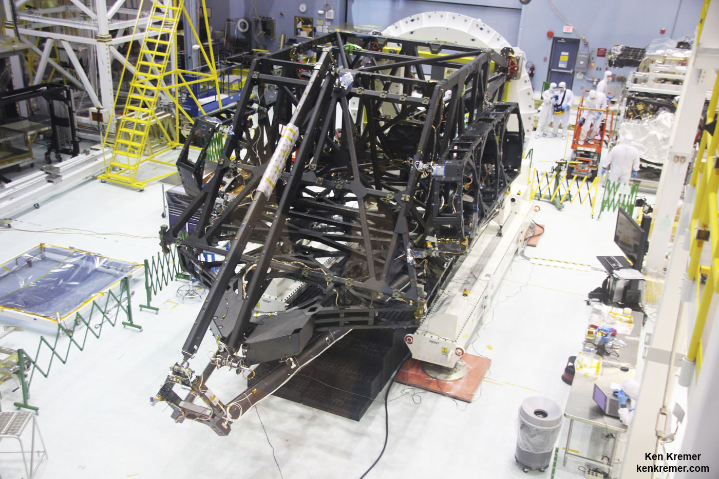
View showing actual flight structure of mirror backplane unit for NASA’s James Webb Space Telescope (JWST) that holds 18 segment primary mirror array and secondary mirror mount at front, in stowed-for-launch configuration. JWST is being assembled here by technicians inside the world’s largest cleanroom at NASA Goddard Space Flight Center, Greenbelt, Md. Credit: Ken Kremer/kenkremer.com
The environmental testing is being done at Goddard before shipping the huge structure to NASA’s Johnson Space Center in February 2017 for further ultra low temperature testing in the cryovac thermal vacuum chamber.
The 6.5 meter diameter ‘golden’ primary mirror is comprised of 18 hexagonal segments – looking honeycomb-like in appearance.
And it’s just mesmerizing to gaze at – as I had the opportunity to do on a few occasions at Goddard this past year – standing vertically in November and seated horizontally in May.
Each of the 18 hexagonal-shaped primary mirror segments measures just over 4.2 feet (1.3 meters) across and weighs approximately 88 pounds (40 kilograms). They are made of beryllium, gold coated and about the size of a coffee table.
All 18 gold coated primary mirrors of NASA’s James Webb Space Telescope are seen fully unveiled after removal of protective covers installed onto the backplane structure, as technicians work inside the massive clean room at NASA’s Goddard Space Flight Center in Greenbelt, Maryland on May 3, 2016. The secondary mirror mount booms are folded down into stowed for launch configuration. Credit: Ken Kremer/kenkremer.com
The Webb Telescope is a joint international collaborative project between NASA, the European Space Agency (ESA) and the Canadian Space Agency (CSA).
Webb is designed to look at the first light of the Universe and will be able to peer back in time to when the first stars and first galaxies were forming. It will also study the history of our universe and the formation of our solar system as well as other solar systems and exoplanets, some of which may be capable of supporting life on planets similar to Earth.
Gold coated primary mirrors newly exposed on spacecraft structure of NASA’s James Webb Space Telescope inside the massive clean room at NASA’s Goddard Space Flight Center in Greenbelt, Maryland on May 3, 2016. Aft optics subsystem stands upright at center of 18 mirror segments between stowed secondary mirror mount booms. Credit: Ken Kremer/kenkremer.com
Watch this space for my ongoing reports on JWST mirrors, science, construction and testing.
Stay tuned here for Ken’s continuing Earth and Planetary science and human spaceflight news.
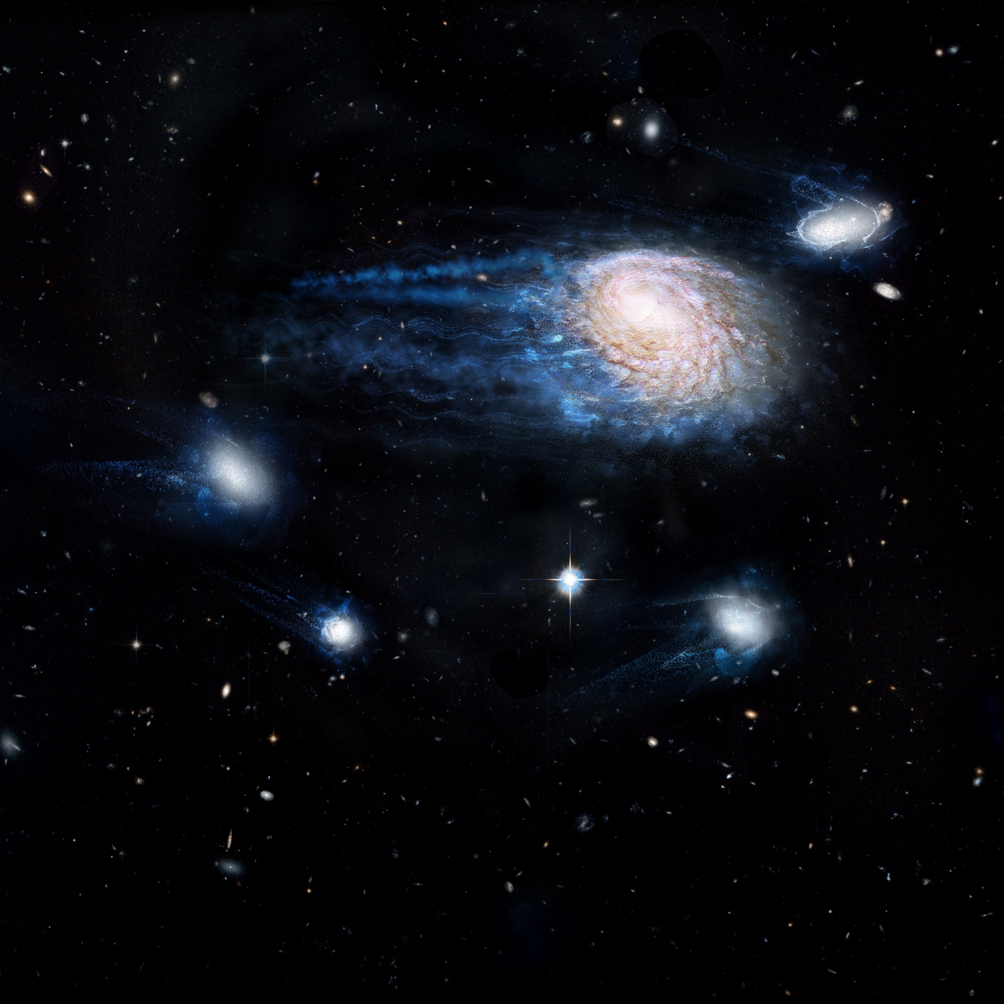
Artist’s impression showing the increasing effect of ram-pressure stripping in removing gas from galaxies, sending them to an early death. Credit: ICRAR/NASA/ESA/Hubble Heritage Team (STScI/AURA)
It’s what you might call a case of galactic homicide (or “galacticide”). All over the known Universe, satellite galaxies are slowly being stripped of their lifeblood – i.e. their gases. This process is responsible for halting the formation of new stars, and therefore condemning these galaxies to a relatively quick death (by cosmological standards). And for some time, astronomers have been searching for the potential culprit.
But according to a new study by a team of international researchers from the International Center for Radio Astronomy Research (ICRAR) in Australia, the answer may have to do with the hot gas galactic clusters routinely pass through. According to their study, which appeared recently in The Monthly Notices of the Royal Astronomical Society, this mechanism may be responsible for the slow death we are seeing out there.
This process is known as “ram-pressure stripping“, which occurs when the force created by the passage of galaxies through the hot plasma that lies between them is strong enough that it is able to overcome the gravitational pull of those galaxies. At this point, they lose gas, much in the same way that a planet’s atmosphere can be slowly stripped away by the effects of Solar wind.
‘Radio color’ view of the sky above the Murchison Widefield Array radio telescope, part of the International Center for Radio Astronomy Research (ICRAC). Credit: Natasha Hurley-Walker (ICRAR/Curtin)/Dr John Goldsmith/Celestial Visions.
By measuring the amount of stripping that took place within each, they deduced that the extent to which a galaxy was stripped of its essential gases had much to do with the mass of its dark matter halo. For some time, astronomers have believed that galaxies are embedded in clouds of this invisible mass, which is believed to make up 27% of the known Universe.
“During their lifetimes, galaxies can inhabit halos of different sizes, ranging from masses typical of our own Milky Way to halos thousands of times more massive. As galaxies fall through these larger halos, the superheated intergalactic plasma between them removes their gas in a fast-acting process called ram-pressure stripping. You can think of it like a giant cosmic broom that comes through and physically sweeps the gas from the galaxies.”
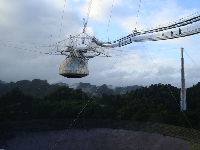
The Arecibo Observatory in Puerto Rico, where the Arecibo Legacy Fast ALFA Survey is conducted. Credit: egg.astro.cornell.edu
This stripping is what deprives satellites galaxies of their ability to form new stars, which ensures that the stars they have enter their red giant phase. This process, which results in a galaxy populated by cooler stars, makes them that much harder to see in visible light (though still detectable in the infrared band). Quietly, but quickly, these galaxies become cold, dark, and fade away.
Already, astronomers were aware of the effects of ram-pressure stripping of galaxies in clusters, which boast the largest dark matter halos found in the Universe. But thanks to their study, they are now aware that it can affect satellite galaxies as well. Ultimately, this shows that the process of ram-pressure stripping is more prevalent than previously thought.
As Dr. Barbara Catinella, an ICRAR researcher and co-author on the study, put it:
“Most galaxies in the Universe live in these groups of between two and a hundred galaxies. We’ve found this removal of gas by stripping is potentially the dominant way galaxies are quenched by their surroundings, meaning their gas is removed and star formation shuts down.”
Another major way in which galaxies die is known as “strangulation”, which occurs when a galaxy’s gas is consumed faster than it can be replenished. However, compared to ram-pressure stripping, this process is very gradual, taking billions of years rather than just tens of millions – very fast on a cosmological time scale. Also, this process is more akin to a galaxy suffering from famine after outstripping its food source, rather than homicide.
Another cosmological mystery solved, and one that has crime-drama implications no less!
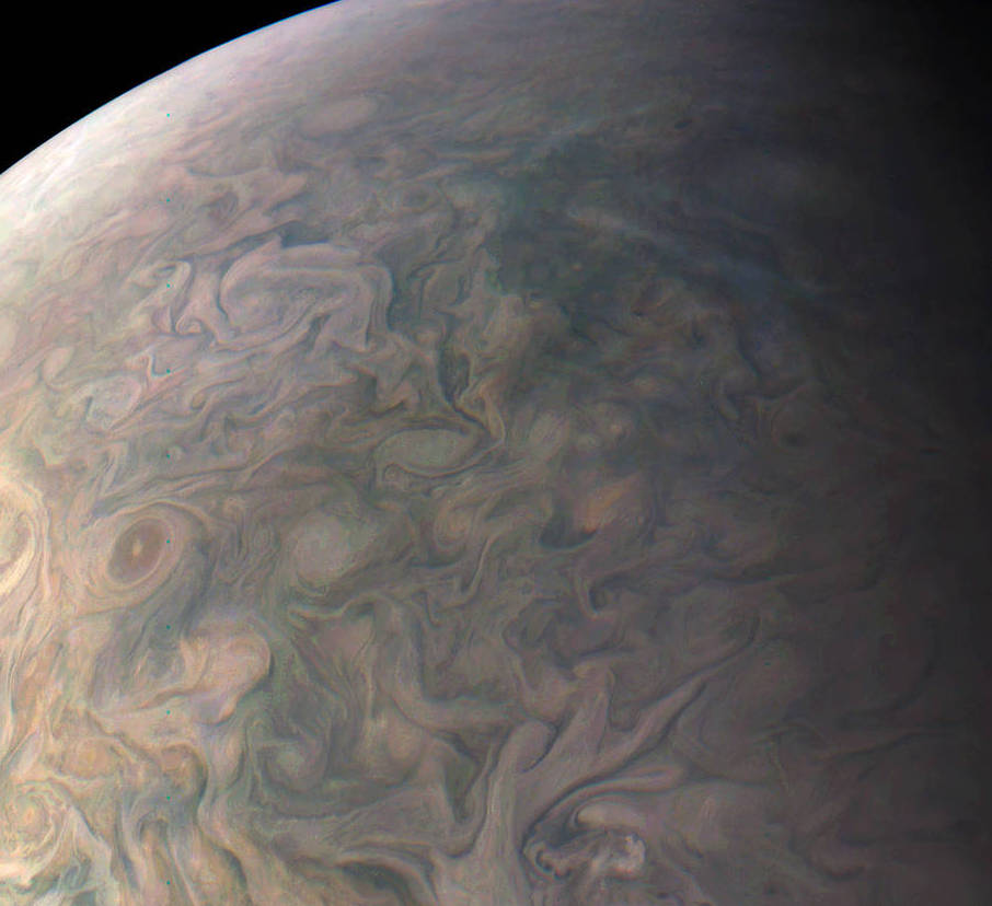
A portion of a new image taken by the JunoCam imager on NASA’s Juno spacecraft of Jupiter’s northern latitudes on Dec. 11, 2016. Credit: NASA/JPL-Caltech/SwRI/MSSS/Gerald Eichstaedt/John Rogers.
Wow! If you’ve ever wanted to know what it would be like to hang above Jupiter’s clouds, here you go. This absolutely stunning view of Jupiter’s northern latitudes shows incredible detail of gas giant’s swirling cloudtops. And it features, in the lower left in the image below, the storm on the gas planet known as NN-LRS-1, or more colloquially, the Little Red Spot.
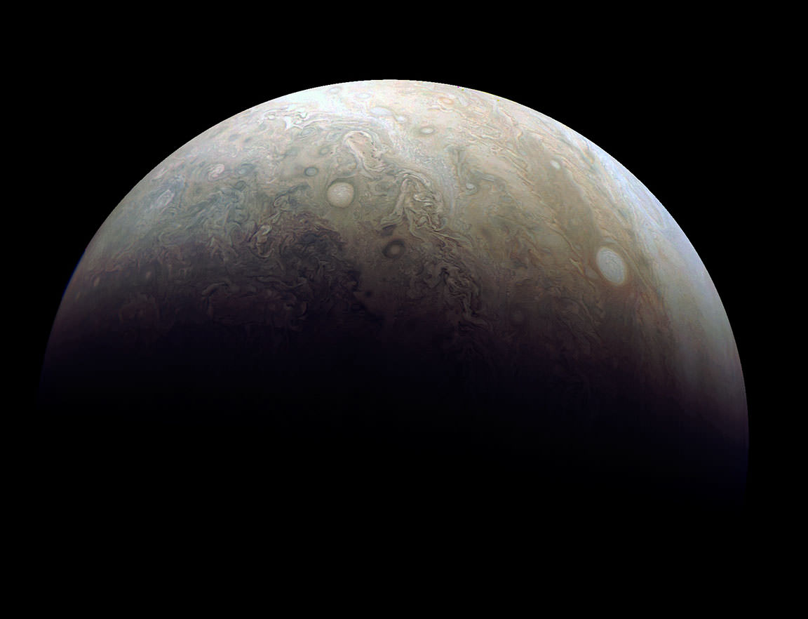
The JunoCam imager on NASA’s Juno spacecraft snapped this shot of Jupiter’s northern latitudes on Dec. 11, 2016. Credit: NASA/JPL-Caltech/SwRI/MSSS/Gerald Eichstaedt/John Rogers.
Juno’s JunoCam, a visible light camera, is able to get never-before-seen images like this because it is doing something that no other mission to Jupiter has done.
“The spacecraft’s proximity to Jupiter is very unusual,” Rick Nybakken told me during an interview at JPL last year. Nybakken is Juno’s project manager. “Juno has an elliptical orbit that brings it just 3,107 miles (5,000 km) above the cloud tops. No other mission has been this close, and we’re right on top of Jupiter so to speak.”
Special instruments are studying Jupiter’s radiation belt and magnetosphere, its interior structure, and the turbulent atmosphere, as well as providing views of the planet with spectacular, close-up images.
And another great thing about this image is that it was processed by citizen scientists. Gerald Eichstaedt and John Rogers processed the image and drafted the caption, and this will be the norm for many of the JunoCam images, because it’s “the public’s camera.”
“I’m excited though for what we’re doing with the visible light camera,” said Juno Project Scientist Steve Levin, who I also interviewed at JPL. “We’re making JunoCam as much as much as we possibly can an instrument that belongs to the public. We’ll solicit the aid of the public in picking which images to take, and releasing the data in its rawest form, and allow people to go and make the images.”
Scientist Candy Hansen is leading this citizen science effort, and she uses the phrase, “science in a fishbowl,” meaning the JunoCam team is showing people what it is like to do science by allowing anyone to participate and see the data as it arrives from Juno.
Damian Peach reprocessed one of the latest images taken by Juno’s JunoCam during its 3rd close flyby of the planet on Dec. 11. The photo highlights two large ‘pearls’ or storms in Jupiter’s atmosphere. Credit: NASA/JPL-Caltech/SwRI/MSSS
You can find the raw images here, so go ahead and test out your image processing skills.
JunoCam is designed to capture remarkable pictures of Jupiter’s poles and cloud tops. Although its images will be helpful to the science team to help provide context for the spacecraft’s other instruments, it is not considered one of the mission’s science instruments. JunoCam was included on the spacecraft specifically for purposes of engaging and including the public.
The Little Red Spot is the third largest anticyclonic oval on the planet, which Earth-based observers have tracked for the last 23 years. An anticyclone is a weather phenomenon with large-scale circulation of winds around a central region of high atmospheric pressure. They rotate clockwise in the northern hemisphere, and counterclockwise in the southern hemisphere. The Little Red Spot shows very little color these days, just a pale brown smudge in the center. Back in 2006, the storm was stronger and the color changed darker and more red. Now, with the storm not quite as active, the color is very similar to the surroundings, making it difficult to see.
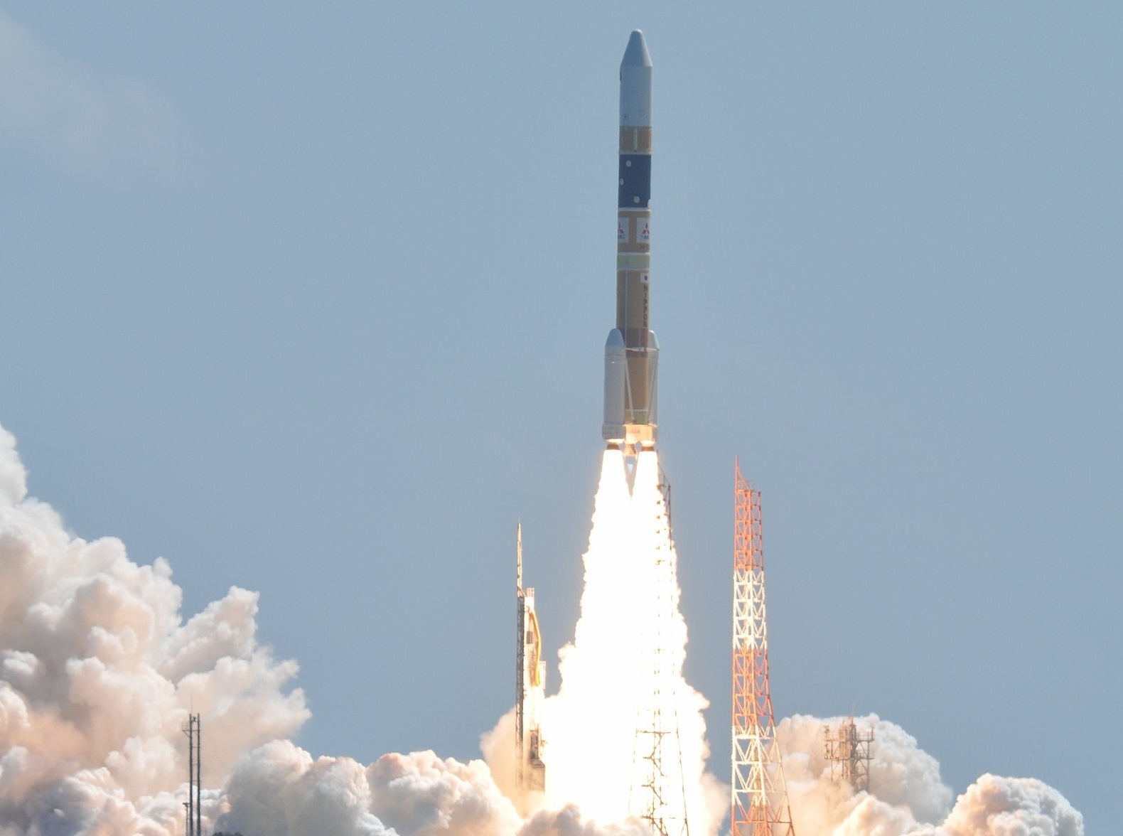
JAXA's H-IIA Launch Vehicle taking off from the Tanegashima Space Center. Credit: Wikipedia Commons/NARITA Masahiro
The Japanese Aerospace Exploration Agency (JAXA) has accomplished some impressive things over the years. Between 2003 (when it was formed) and 2016, the agency has launched multiple satellites – ranging from x-ray and infrared astronomy to lunar and Venus atmosphere exploration probes – and overseen Japan’s participation in the International Space Station.
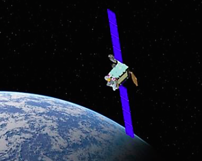
But in what is an historic mission – and a potentially controversial one – JAXA recently launched the first of three X-band defense communication satellites into orbit. By giving the Japanese Self-Defense Forces the ability to relay communications and commands to its armed forces, this satellite (known as DSN 2) represents an expansion of Japan’s military capability.
The launch took place on January 24th at 4:44 pm Japan Standard Time (JST) – or 0744 Greenwich Mean Time (GMT) – with the launch of a H-IIA rocket from Tanegashima Space Center. This was the thirty-second successful flight of the launch vehicle, and the mission was completed with the deployment of the satellite in Low-Earth Orbit – 35,000 km; 22,000 mi above the surface of the Earth.
Artist’s concept of a Japanese X-band military communications satellite. Credit: Japanese Ministry of Defense
Shortly after the completion of the mission, JAXA issued a press release stating the following:
“At 4:44 p.m., (Japan Standard Time, JST) January 24, Mitsubishi Heavy Industries, Ltd. and JAXA launched the H-IIA Launch Vehicle No. 32 with X-band defense communication satellite-2* on board. The launch and the separation of the satellite proceeded according to schedule. Mitsubishi Heavy Industries, Ltd. and JAXA express appreciation for the support in behalf of the successful launch. At the time of the launch the weather was fine, at 9 degrees Celsius, and the wind speed was 7.1 meters/second from the NW.”
This launch is part of a $1.1 billion program by the Japanese Defense Ministry to develop X-band satellite communications for the Japan Self-Defense Forces (JSDF). With the overall goal of deploying three x-band relay satellites into geostationary orbit, its intended purpose is to reduce the reliance of Japan’s military (and those of its allies) on commercial and international communications providers.
While this may seem like a sound strategy, it is a potential source of controversy in that it may skirt the edge of what is constitutionally permitted in Japan. In short, deploying military satellites is something that may be in violation of Japan’s post-war agreements, which the nation committed to as part of its surrender to the Allies. This includes forbidding the use of military force as a means of solving international disputes.
An H-2A rocket, Japan’s primary large-scale launch vehicle. Credit: JAXA
It also included placing limitations on its Self-Defense Forces so they would not be capable of independent military action. As is stated in Article 9 of the Constitution of Japan (passed in 1947):
“(1) Aspiring sincerely to an international peace based on justice and order, the Japanese people forever renounce war as a sovereign right of the nation and the threat or use of force as means of settling international disputes.
(2) In order to accomplish the aim of the preceding paragraph, land, sea, and air forces, as well as other war potential, will never be maintained. The right of belligerency of the state will not be recognized.”
However, since 2014, the Japanese government has sought to reinterpret Article 9 of the constitution, claiming that it allows the JSDF the freedom to defend other allies in case of war. This move has largely been in response to mounting tensions with North Korea over its development of nuclear weapons, as well as disputes with China over issues of sovereignty in the South China Sea.
This interpretation has been the official line of the Japanese Diet since 2015, as part of a series of measures that would allow the JSDF to provide material support to allies engaged in combat internationally. This justification, which claims that Japan and its allies would be endangered otherwise, has been endorsed by the United States. However, to some observers, it may very well be interpreted as an attempt by Japan to re-militarize.
In the coming weeks, the DSN 2 spacecraft will use its on-board engine to position itself in geostationary orbit, roughly 35,800 km (22,300 mi) above the equator. Once there, it will commence a final round of in-orbit testing before commencing its 15-year term of service.
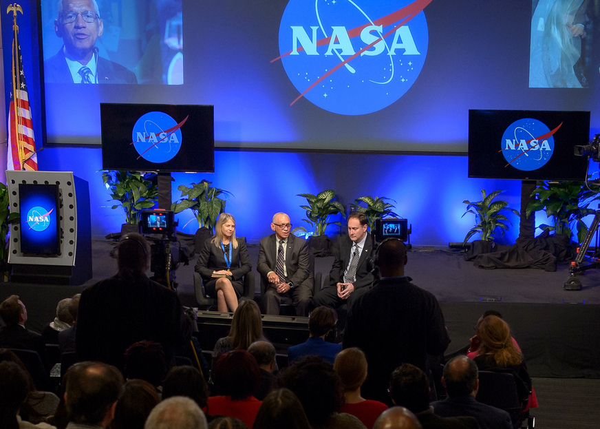
A NASA town hall meeting on Jan. 12, 2017 at NASA Headquarters with NASA employees, featured outgoing Deputy Administrator Dava Newman, left, NASA Administrator Charles Bolden, center, and the now acting NASA Administrator Robert Lightfoot. Credit: (NASA/Bill Ingalls)
The Trump Administration appears to be trying to change how government agencies disseminate information to the public. According to reports from multiple outlets, several agencies are being told to discontinue or suppress communications with the public, the media and even Congress.
Additionally, Reuters is reporting that the Trump administration has instructed the Environmental Protection Agency (EPA) to remove information about climate change from its website. (An update today from The Hill quotes Doug Ericksen, EPA transition team spokesman as they are only “taking a look at everything on there.”)
All this has anyone interested in NASA’s activities wondering if the US space agency could be ordered to stifle its very active social media presence, or to remove the extensive information it has available on several NASA-related sites on climate change.
Universe Today contacted several NASA sources to see if the space agency has received any orders similar to the other agencies. All indications appear that, for now, NASA has not received any such orders.
John Yembrick, who heads NASA Headquarters’ social media team told us via email that “Nothing has changed here at NASA. We are continuing to share information about our missions on social media.”
Another NASA employee who wished to remain anonymous said they would be surprised and horrified if the social media blocks would extend to NASA but it seems nothing is out of the question now.
This morning, several NASA social media accounts on Twitter and Facebook are posting as usual.
Jeff Foust from Space News reported on Twitter last night that he attended a talk by Michael Freilich, the director of NASA’s Earth science division at the meeting of the American Meteorological Society (AMS) going on this week in Seattle, Washington, and Freilich was asked if NASA been given direction like EPA and other agencies to not communicate with public. Foust tweeted that Freilich said they “have been given no direction to change” and that the transition to the new administration’s “landing team” of about eight people at NASA has gone smoothly.
NASA’s ‘meatball’ logo.
It is important to remember that federal law has required NASA to widely disseminate information about its activities and scientific research in a timely way. National Aeronautics and Space Act of 1958 chartered NASA to “provide for the widest practicable and appropriate dissemination of information concerning its activities and the results thereof.”
The anonymous NASA source Universe Today talked to said the bigger issue for them right now is the hiring freeze that was imposed on all government agencies, and a possible grant freeze, such as the freezes posed on the EPA. Many scientists and graduate student work programs rely on grants for their salaries.
Other agencies that have been reportedly muzzled are the Interior Department (and the National Park Service), the Department of Agriculture (USDA), Department of Commerce, and Health and Human Services. All this is sparking concerns that the new president might be attempting to silence any dissenting views and control any information from federal agencies.
A news article out this morning says the USDA has now “disavowed the gag order”, calling it “flawed” and indicating that new guidance would be sent to its employees.
“This internal email was released without Departmental direction, and prior to Departmental guidance being issued,” the USDA said in a statement.
Is This ‘Normal?’
It’s important to point out that previous incoming presidential administrations have placed somewhat similar restrictions on limiting communications during the transition in order to have consistent messages come out across agencies.
But of course, there hasn’t been a new administration for eight years, and during those years the amount of information government agencies have made available on the internet has increased exponentially, and participation on social media has exploded. So, the moves to limit or silence the information disseminated by the agencies via online outlets is therefore unprecedented.
And many say this presidential transition feels completely different from any before.
National Public Radio (NPR) correspondent Nathan Rott interviewed Andrew Light, Senior Fellow in the Climate Program at the World Resources Institute in Washington, D.C., who formerly worked at the State Department. Light said the muzzling of agencies “seems to be aimed at a cluster of science-driven agencies that primarily work on the environment or climate change, and that seems unique or targeted in this case and unprecedented.”
You can listen to the NPR interview below:
The two highest people in leadership at NASA under the Obama Administration, Administrator Charles Bolden and Deputy Administrator Dava Newman, both stepped down on January 20 at the end of Obama’s term. NASA Associate Administrator Robert Lightfoot was named as acting administrator of NASA. Two White House appointees were named, Erik Noble as White House senior advisor and Greg Autry as White House liaison, part of an eight-member “landing team” assigned to NASA by Trump’s transition team.
Autry is an assistant professor of entrepreneurship at the University of Southern California. He has been “a proponent of commercial space activities,” according to Space News. Noble, who earned a Ph.D. in environmental studies from the University of Colorado, spent seven years at the NASA Goddard Institute of Space Studies in New York, working on weather and climate models.
Concern about agencies being silenced were heightened yesterday when a National Park Service (NPS) Twitter account from the Badlands National Park in South Dakota began posting information about climate change, which were later deleted. The NPS told media outlets that a former employee without approved access wrote the Tweets and that’s why they were deleted.
A screenshot of a now-deleted Tweet from the Badlands National Park Twitter account.
This came just days after the NPS was told to shut down its Twitter activity over two retweets about crowd sizes at presidential inaugurations. The Department of the Interior said those tweets were deemed inconsistent with the agency’s mission.
About 60 science and journalism organizations have requested a meeting with President Trump and Vice President Mike Pence to discuss access to government, but the newly elected team has not replied to the request.
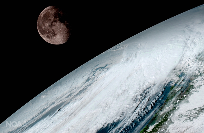
GOES-16 (previously known as GOES-R) captured this view of the moon as it looked across the surface of the Earth on January 15, 2017. Like earlier GOES satellites, GOES-16 will use the moon for calibration. Credit: NOAA/NASA
GOES-16 (previously known as GOES-R) captured this view of the moon as it looked across the surface of the Earth on January 15, 2017. Like earlier GOES satellites, GOES-16 will use the moon for calibration. Credit: NOAA/NASA
KENNEDY SPACE CENTER, FL – A new age has begun in the nations weather forecasting capabilities with the release today (Jan. 23) of the spectacular first images gathered by the recently launched NASA/NOAA GOES-16 observatory.
“It will be like high-definition from the heavens,” says NOAA.
“Today’s release of the first images from #GOES16 signals the start of a new age in satellite weather observation!!!”
Thus the newly obtained and published imagery has been anxiously awaited by scientists, meteorologists and ordinary weather enthusiasts.
“This is such an exciting day for NOAA! One of our GOES-16 scientists compared this to seeing a newborn baby’s first pictures — it’s that exciting for us,” said Stephen Volz Ph.D. director of NOAA’s Satellite and Information Service, in a statement.
“These images come from the most sophisticated technology ever flown in space to predict severe weather on Earth. The fantastically rich images provide us with our first glimpse of the impact GOES-16 will have on developing life-saving forecasts.”
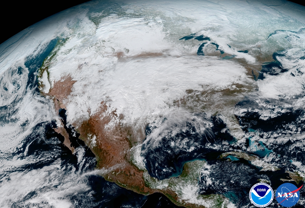
This image clearly shows the significant storm system that crossed North America that caused freezing and ice that resulted in dangerous conditions across the United States on January 15, 2017 resulting in loss of life. Credit: NOAA/NASA
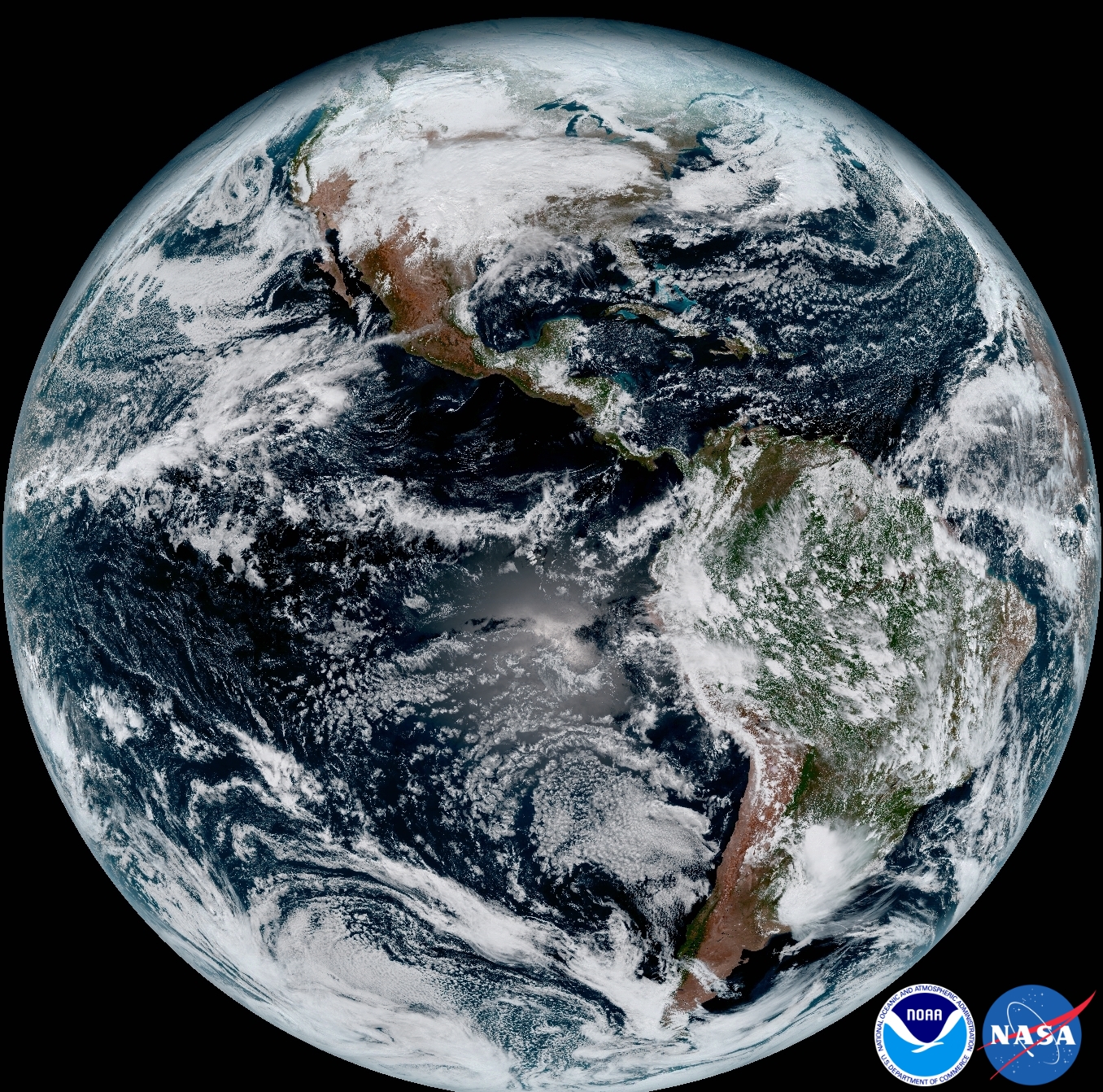
An especially eye-popping image taken by GOES -16 from its equatorial vantage point situated in geostationary orbit 22,300 miles (35,800 kilometers) above Earth and published today, shows both the Earth and the Moon together – as the lead image here.
The Earth/Moon combo shot is not only fantastically pleasing to the eye, but also serves a significant scientific purpose.
“Like earlier GOES satellites, GOES-16 will use the moon for calibration,” say NOAA officials.
“GOES-16 will boost the nation’s weather observation network and NOAA’s prediction capabilities, leading to more accurate and timely forecasts, watches and warnings.”
GOES-16 is the most advanced and powerful weather observatory ever built and will bring about a ‘quantum leap’ in weather forecasting.
“Seeing these first images from GOES-16 is a foundational moment for the team of scientists and engineers who worked to bring the satellite to launch and are now poised to explore new weather forecasting possibilities with this data and imagery,” said Volz.
“The incredibly sharp images are everything we hoped for based on our tests before launch. We look forward to exploiting these new images, along with our partners in the meteorology community, to make the most of this fantastic new satellite.”
It’s dramatic new imagery will show the weather in real time enabling critical life and property forecasting, help pinpoint evacuation zones and also save people’s lives in impacted areas of severe weather including hurricanes and tornadoes.
And the huge satellite can’t come online soon enough, as demonstrated by the severe winter weather and tornadoes that just wreaked havoc and death in various regions of the US.
Another breathtaking image product (seen below) produced by the GOES-16 Advanced Baseline Imager (ABI) instrument, built by Harris Corporation, shows a full-disc view of the Western Hemisphere in high detail — at four times the image resolution of existing GOES spacecraft.
This composite color full-disk visible image shows North and South America and was taken on January 15, 2017. It was created using several of the 16 spectral channels available on the GOES-16 Advanced Baseline Imager (ABI) instrument. Credit: NOAA/NASA
The 11,000 pound satellite was built by prime contractor Lockheed Martin and is the first of a quartet of four identical satellites – comprising GOES-R, S, T, and U – at an overall cost of about $11 Billion. This will keep the GOES satellite system operational through 2036.
This next generation of GOES satellites will replace the currently operating GOES East and GOES West satellites.
NOAA will soon decide whether GOES-16 will replace either the East or West satellites. A decision from NOAA is expected in May. GOES-16 will be operational by November 2017 as either the GOES-East or GOES-West satellite. Of course everyone wants it first.
The next satellite is nearing assembly completion and will undergo about a year of rigorous environmental and acoustic testing before launch. It will go to whichever slot was not selected this year.
This 16-panel image shows the continental United States in the two visible, four near-infrared and 10 infrared channels on the Advanced Baseline Imager (ABI). These channels help forecasters distinguish between differences in the atmosphere like clouds, water vapor, smoke, ice and volcanic ash. Credit: NOAA/NASA
The six instrument science suite includes the Advanced Baseline Imager (ABI) built by Harris Corporation, the Geostationary Lightning Mapper (GLM) built by Lockheed Martin, Solar Ultraviolet Imager (SUVI), Extreme Ultraviolet and X-Ray Irradiance Sensors (EXIS), Space Environment In-Situ Suite (SEISS), and the Magnetometer (MAG).
ABI is the primary instrument and will collect 3 times more spectral data with 4 times greater resolution and scans 5 times faster than ever before – via the primary Advanced Baseline Imager (ABI) instrument – compared to the current GOES satellites.
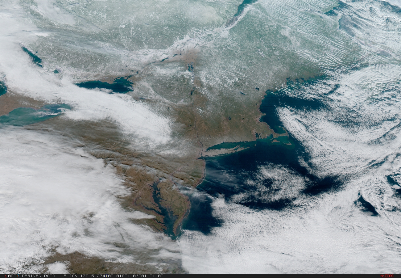
Northeast Coast and New York Metropolitan region. On January 15, 2017 severe weather moved across the central United States before passing through the Northeast on the 16th and 17th where it resulted in wet and wintry weather for travelers across the region. Credit: NOAA/NASA
“The higher resolution will allow forecasters to pinpoint the location of severe weather with greater accuracy. GOES-16 can provide a full image of Earth every 15 minutes and one of the continental U.S. every five minutes, and scans the Earth at five times the speed of NOAA’s current GOES imagers.”
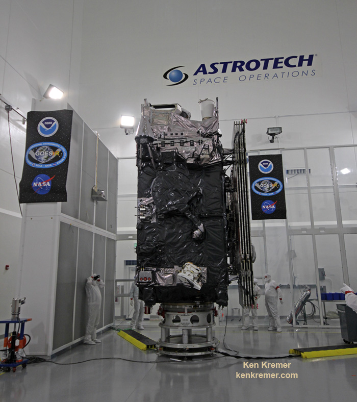
The NASA/NOAA GOES-R (Geostationary Operational Environmental Satellite – R Series) being processed at Astrotech Space Operations, in Titusville, FL, in advance of successful launch on a ULA Atlas V on Nov. 19, 2016. GOES-R/GOES-16 will be America’s most advanced weather satellite. Credit: Ken Kremer/kenkremer.com
Blastoff of revolutionary NASA/NOAA GOES-R (Geostationary Operational Environmental Satellite – R Series) on ULA Atlas V from Space Launch Complex 41 (SLC-41) on Cape Canaveral Air Force Station, Florida on Nov. 19, 2016. GOES-R will deliver a quantum leap in America’s weather forecasting capabilities. Credit: Ken Kremer/kenkremer.com
Stay tuned here for Ken’s continuing Earth and Planetary science and human spaceflight news.
Ken Kremer Florida and The Caribbean. In May 2017, NOAA will announce the planned location for GOES-16. By November 2017, GOES-16 will be operational as either the GOES-East or GOES-West satellite. At its current check out location the satellite captured this image of the Caribbean and Florida. Here the satellite captures the shallows waters of the Caribbean. Credit: NOAA/NASA
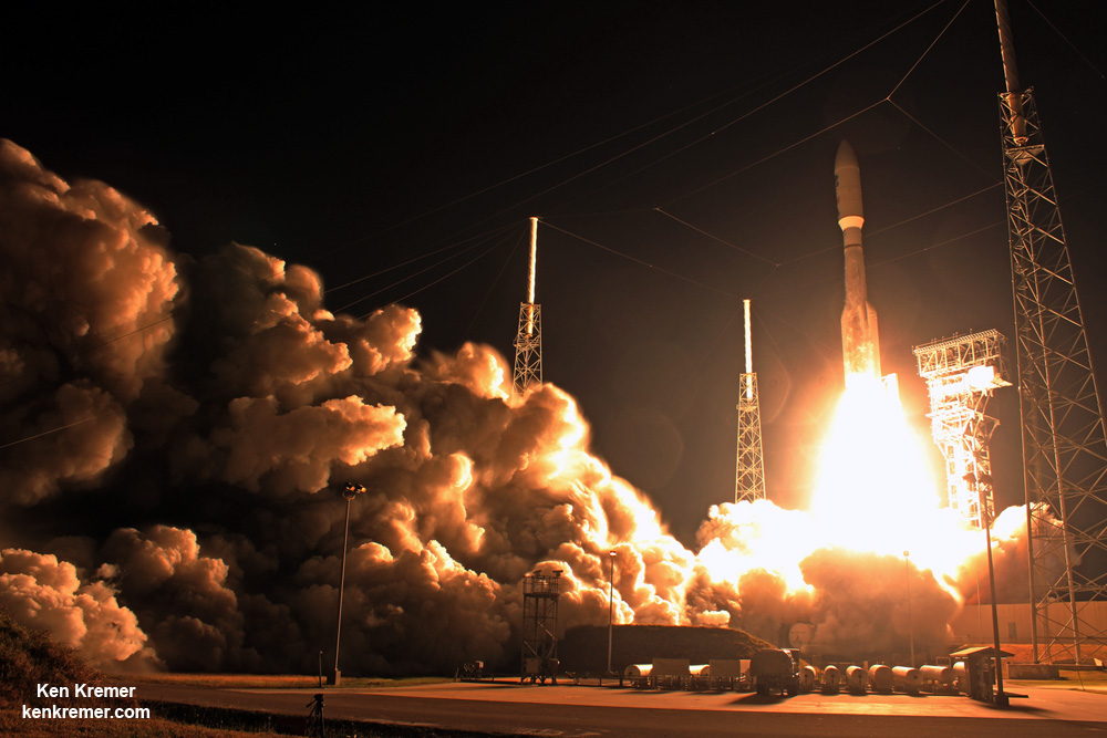
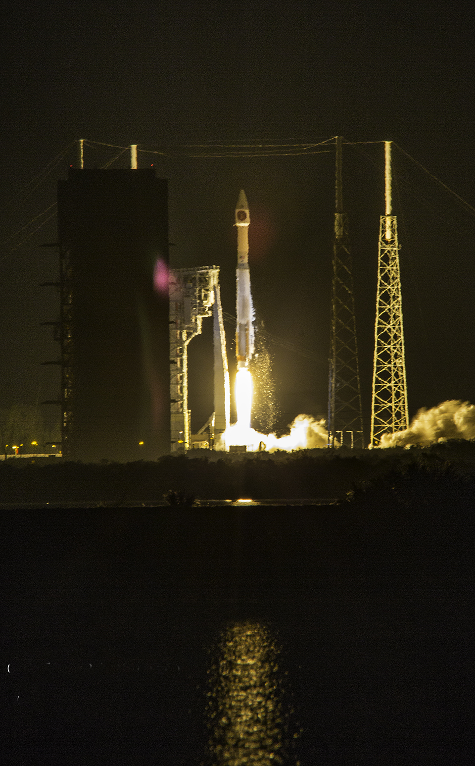
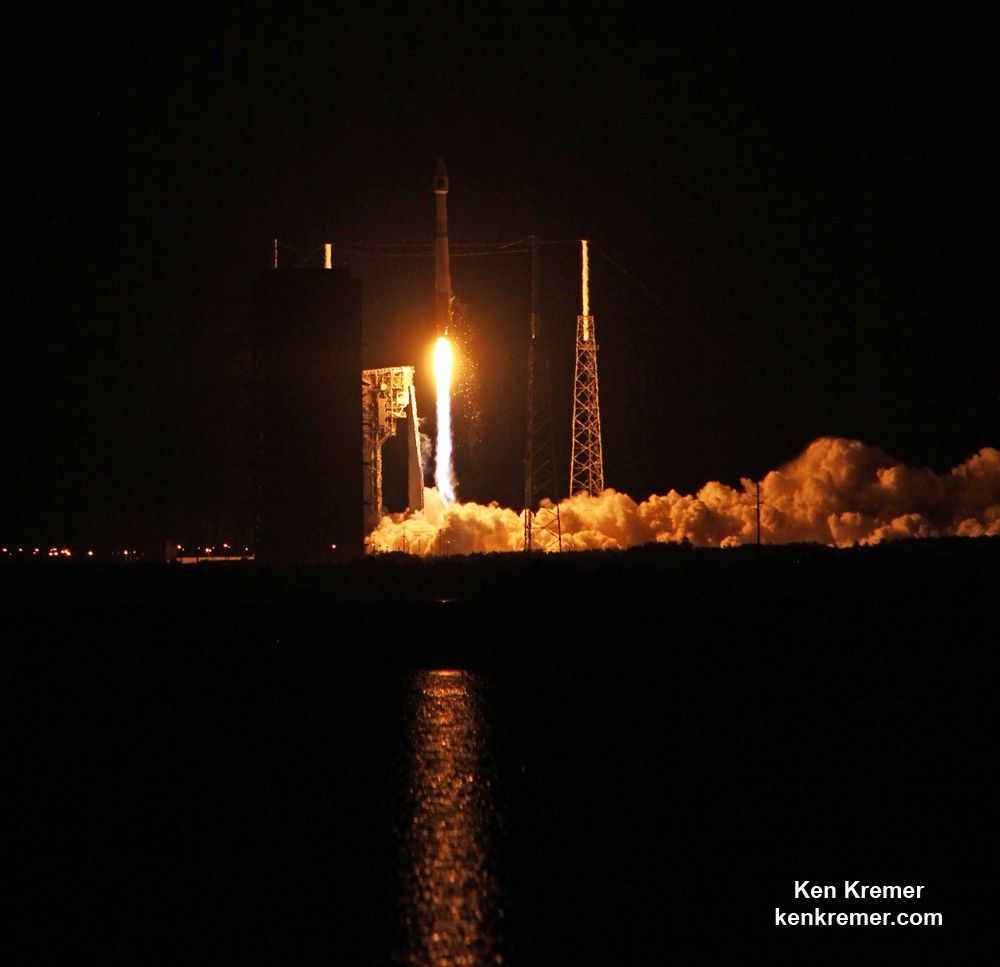
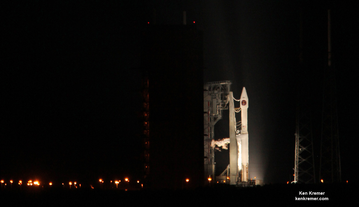
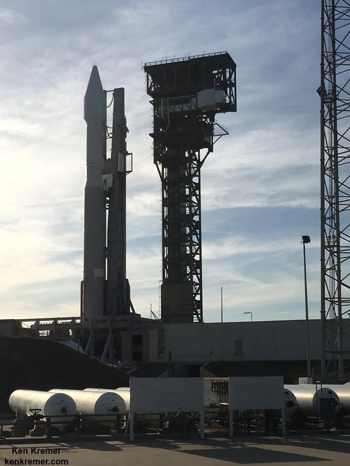
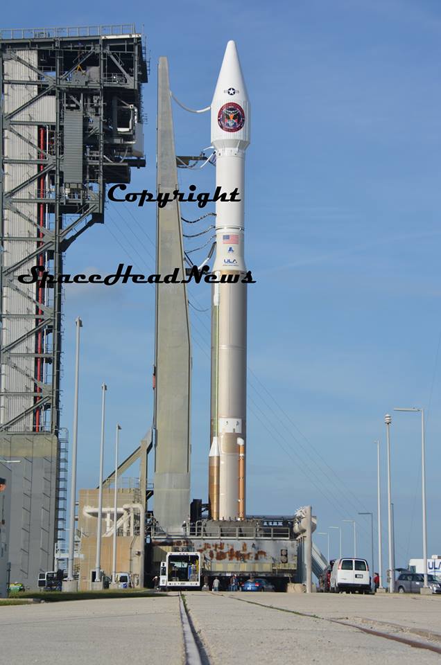
United Launch Alliance (ULA) Atlas V rocket carrying SBIRS GEO Flight 3 early missile warning satellite for USAF lifts off at 7:42 p.m. ET on Jan. 20, 2017 from Space Launch Complex-41 on Cape Canaveral Air Force Station in Florida. Credit: Ken Kremer/kenkremer.com
United Launch Alliance (ULA) Atlas V rocket carrying SBIRS GEO Flight 3 early missile warning satellite for USAF lifts off at 7:42 p.m. ET on Jan. 20, 2017 from Space Launch Complex-41 on Cape Canaveral Air Force Station in Florida. Credit: Ken Kremer/kenkremer.com
The United Launch Alliance Atlas V rocket carrying the $1.2 Billion Space Based Infrared System (SBIRS) GEO Flight 3 infrared imaging satellite lifted off at 7:42 p.m. ET from Space Launch Complex-41 on Cape Canaveral Air Force Station, Fla.
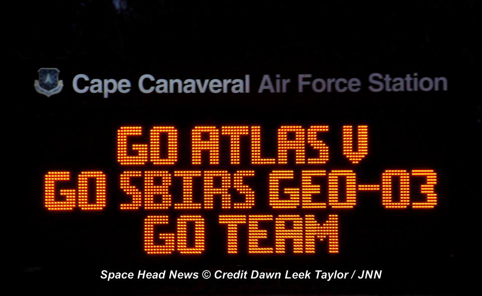
Check out this expanding gallery of eyepopping photos and videos from several space journalist colleagues and friends and myself – for views you won’t see elsewhere.
Click back as the gallery grows !
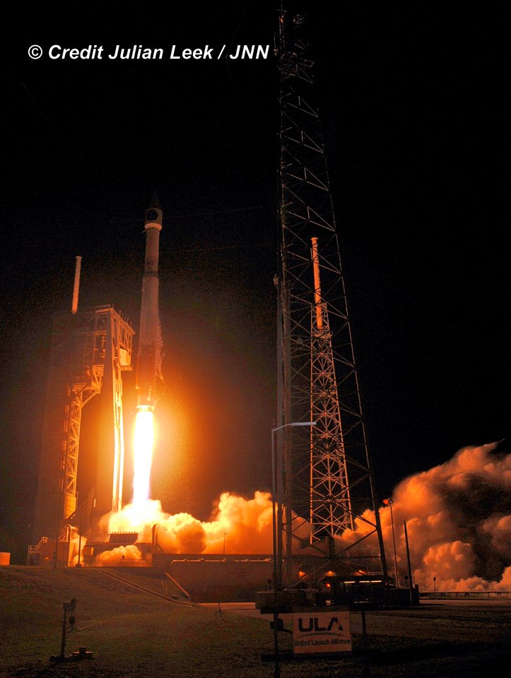
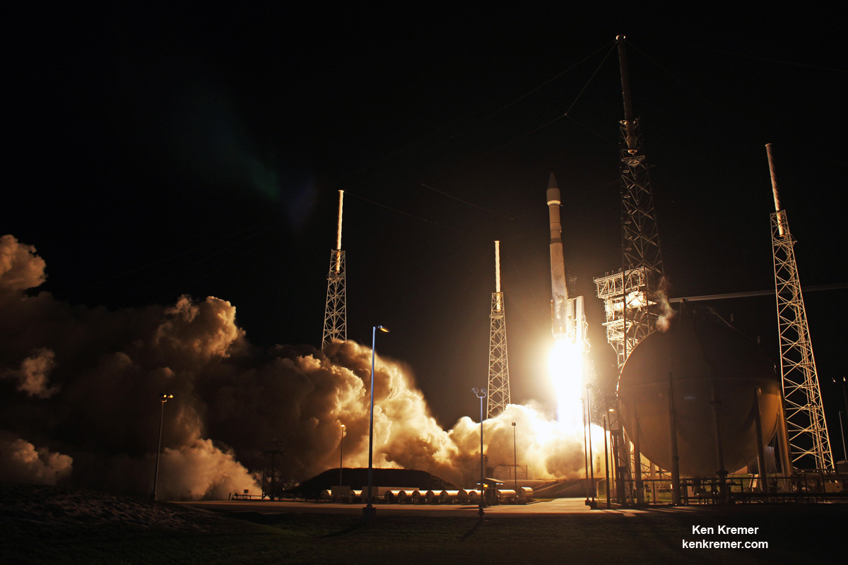
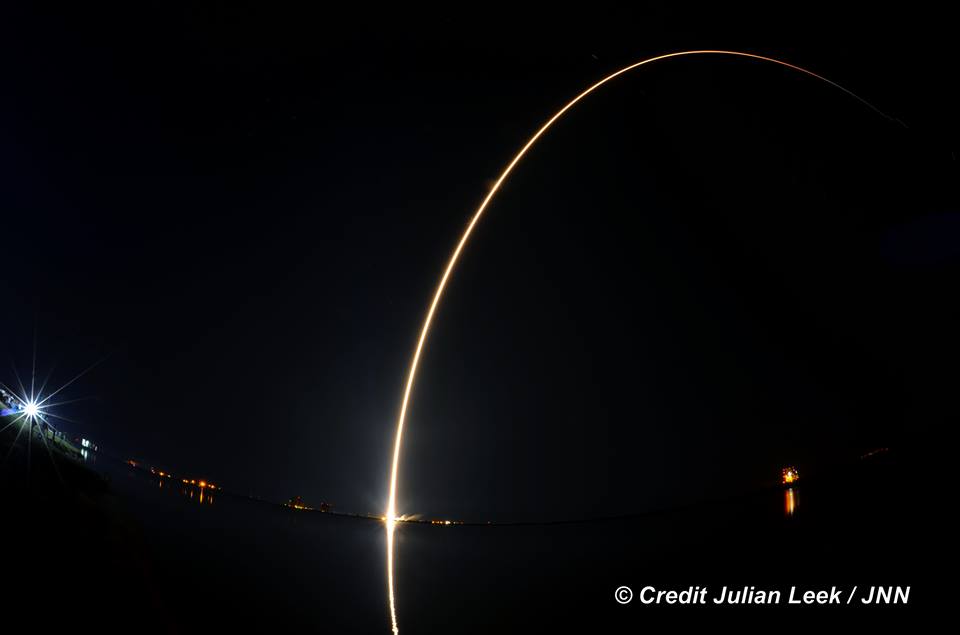
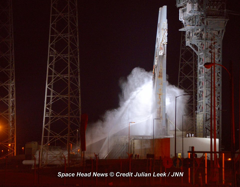
Nighttime blastoff of ULA Atlas V rocket carrying the USAF SBIRS GEO 3 missile defense satellite to orbit on Jan. 20, 2017 from Space Launch Complex-41 at Cape Canaveral Air Force Station in Florida. Credit: Julian Leek
“GEO Flight 3 delivery and launch marks a significant milestone in fulfilling our commitment to the missile-warning community, missile defense and the intelligence community. It’s an important asset for the warfighter and will be employed for years to come,” says Lt. Gen. Samuel Greaves, SMC commander and Air Force program executive officer for space, in a statement.
The Space Based Infrared System is designed to provide global, persistent, infrared surveillance capabilities to meet 21st century demands in four national security mission areas: missile warning, missile defense, technical intelligence and battlespace awareness.
“The hard work and dedication of the launch team has absolutely paid off,” Col. Dennis Bythewood, director of the Remote Sensing Directorate said in a statement.
“Today’s launch of GEO Flight 3 culminates years of preparation by a broad team of government and industry professionals.”
ULA Atlas V launch of USAF SBIRS GEO 3 missile defense satellite on Jan. 20, 2017 from Space Launch Complex-41 at Cape Canaveral Air Force Station in Florida. Credit: Joe Sekora
The SBIRS GEO Flight 3 missile defense observatory built for the USAF will detect and track the infrared signatures of incoming enemy missiles twice as fast as the prior generation of satellites and is vital to America’s national security.
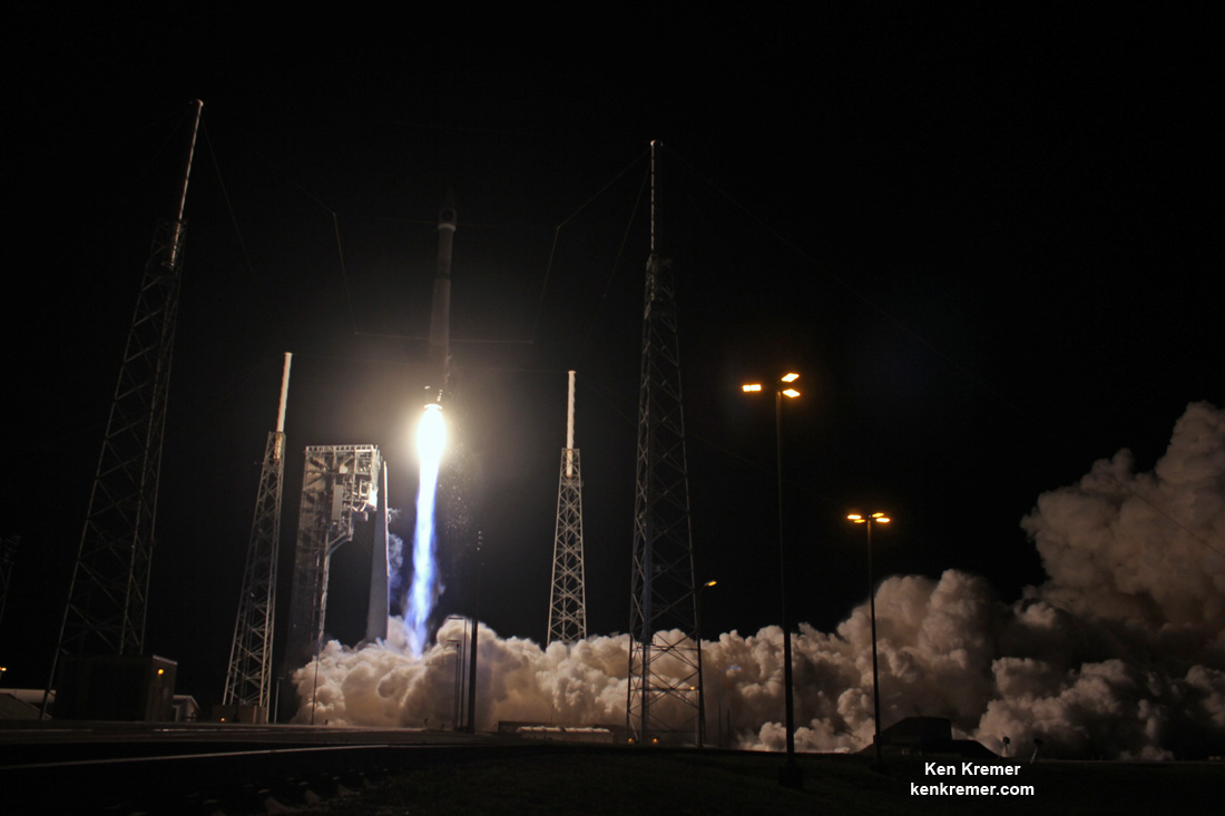
United Launch Alliance (ULA) Atlas V rocket carrying SBIRS GEO Flight 3 missile detection satellite for USAF lifts off at 7:42 p.m. ET on Jan. 20, 2017 from Space Launch Complex-41 on Cape Canaveral Air Force Station in Florida. Credit: Ken Kremer/kenkremer.com
SBIRS GEO Flight 3 was launched to geosynchronous transfer orbit to an altitude approx 22,000 miles (36,000 kilometers) above Earth.
The Atlas V was launched southeast at an inclination of 23.29 degrees. SBIRS GEO Flight 3 separated from the 2nd stage as planned 43 minutes after liftoff.
Following separation, the spacecraft began a series of orbital maneuvers to propel it to a geosynchronous earth orbit. Once in its final orbit, engineers will deploy the satellite’s solar arrays and antennas. The engineers will then complete checkout and tests in preparation for operational use, USAF officials explained.
Watch these eyepopping launch videos as the Atlas V rocket thunders to space – showing different perspectives of the blastoff from remote cameras ringing the pad and from the media’s launch viewing site on Cape Canaveral Air Force Station.
Video Caption: ULA Atlas 5 launch of the SBIRS GEO Flight 3 satellite from Pad 41 of the Cape Canaveral Air Force Station on January 20, 2017. Credit: Jeff Seibert
Video Caption: Launch of SBIRS GEO Flight 3 early missile warning satellite for USAF on a United Launch Alliance (ULA) Atlas V rocket from SLC-41 on Cape Canaveral Air Force Station, Fl., at 7:42 p.m. ET on Jan. 20, 2017 – as seen in this remote video taken at the pad. Credit: Ken Kremer/kenkremer.com
Lockheed Martin is the prime contractor, with Northrop Grumman as the payload integrator.
The SBIRS team is led by the Remote Sensing Systems Directorate at the U.S. Air Force Space and Missile Systems Center. Air Force Space Command operates the SBIRS system.
United Launch Alliance (ULA) Atlas V rocket carrying SBIRS GEO Flight 3 early missile warning satellite for USAF lifts off at 7:42 p.m. ET on Jan. 20, 2017 from Space Launch Complex-41 on Cape Canaveral Air Force Station in Florida. Credit: Ken Kremer/kenkremer.comULA Atlas V rocket carrying SBIRS GEO Flight 3 missile tracking observatory lifts off at 7:42 p.m. ET on Jan. 20, 2017 from Space Launch Complex-41 on Cape Canaveral Air Force Station in Florida. Credit: Ken Kremer/kenkremer.com
Stay tuned here for Ken’s continuing Earth and Planetary science and human spaceflight news.
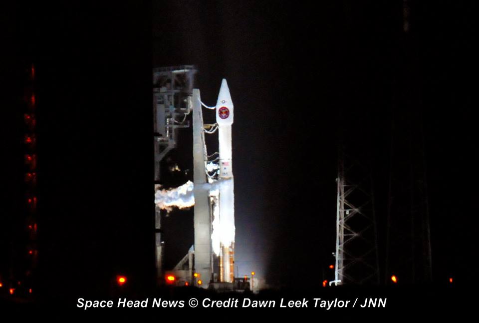
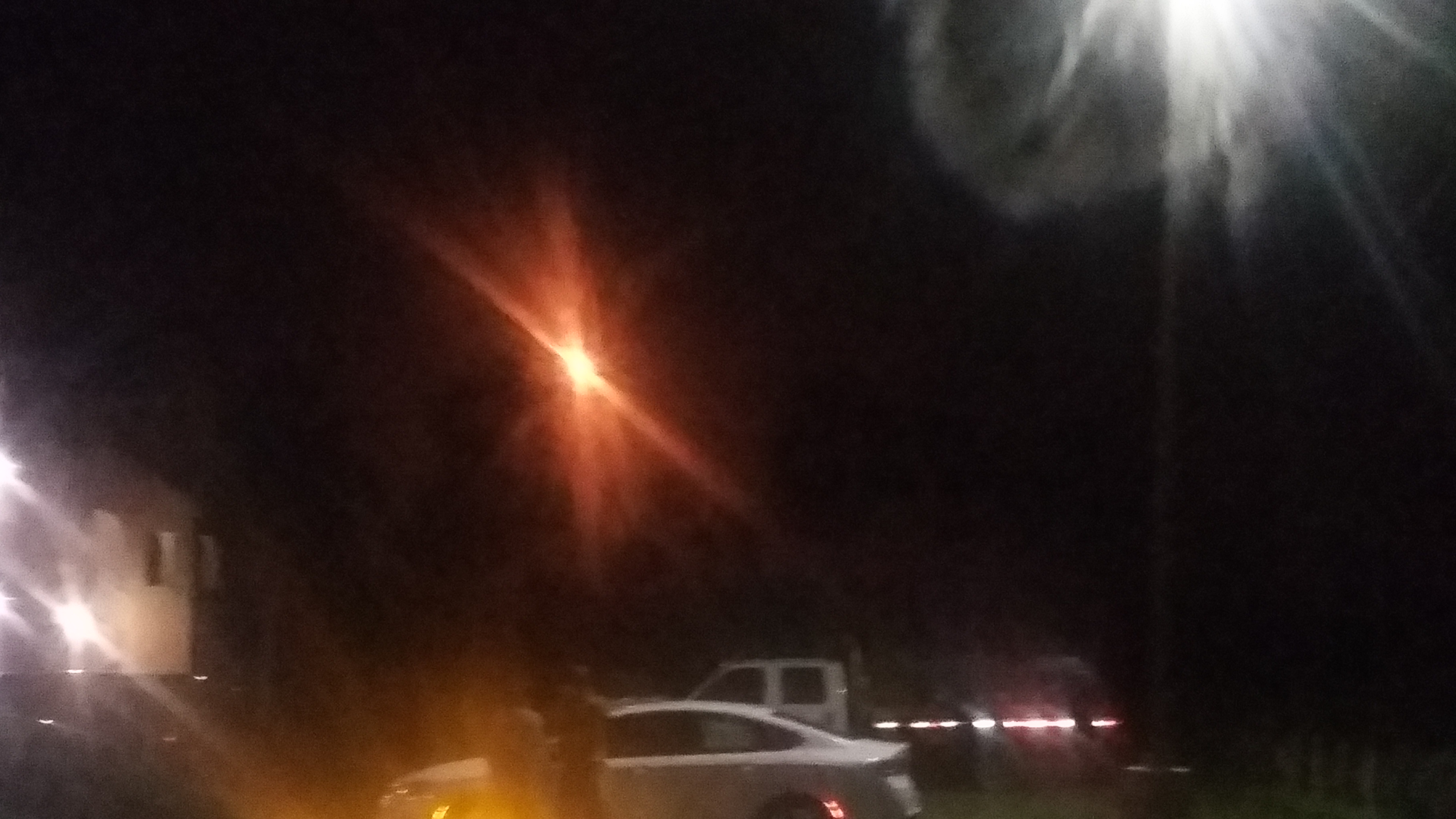
ULA Atlas V rocket carrying the USAF SBIRS GEO 3 missile warning satellite awaits blastoff from pad 41 at Cape Canaveral Air Force Station in Florida on Jan. 20 , 2017. Credit: Dawn TaylorA United Launch Alliance (ULA) Atlas V rocket carrying SBIRS GEO Flight 3 satellite lifts off at 7:42 p.m. ET on Jan. 20, 2017 from Space Launch Complex-41 on Cape Canaveral Air Force Station in Florida. Credit: Ken Kremer/kenkremer.com ULA Atlas V rocket carrying the USAF SBIRS GEO 3 missile warning satellite awaits blastoff from pad 41 at Cape Canaveral Air Force Station in Florida on Jan. 20 , 2017. Credit: Ken Kremer/kenkremer.com ULA Atlas V rocket carrying the USAF SBIRS GEO 3 missile defense satellite streaks to orbit on Jan. 20, 2017 after nighttime blastoff at 7:42 p.m. ET from Space Launch Complex-41 at Cape Canaveral Air Force Station in Florida. Credit: Julian LeekBanner announcing imminent launch of ULA Atlas V and USAF SBIRS GEO 3 from CCAFS on Jan. 20, 2017. Credit: Dawn Taylor Launch of Atlas V and USAF SBIRS GEO 3 missile defense satellite from CCAFS on Jan. 20, 2017 as seen from Titusville, Fl neighborhood. Credit: Melissa BaylesULA Atlas V rocket stands erect alongside newly built crew access tower at Cape Canaveral Air Force Station’s Space Launch Complex-41 ahead of Jan. 19, 2017 blastoff. Credit: Ken Kremer/kenkremer.comLaunch of Atlas V and USAF SBIRS GEO 3 missile defense satellite from CCAFS on Jan. 20, 2017 as seen from Titusville, Fl neighborhood. Credit: Melissa BaylesPad 41 gets hosed down about 1 hour post launch of ULA Atlas V rocket delivering USAF SBIRS GEO 3 missile defense satellite to orbit on Jan. 20, 2017 from Space Launch Complex-41 at Cape Canaveral Air Force Station in Florida. Credit: Julian LeekAtlas V/SBIRS GEO 3 awaits liftoff from pad 41 on Jan. 20, 2017 at Cape Canaveral Air Force Station in Florida. Credit: Lane Hermann
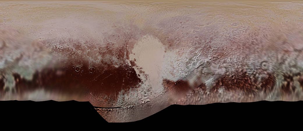
Color mosaic map of Pluto's surface, created from the New Horizons many photographs. Credit: NASA/JHUAPL/SwRI
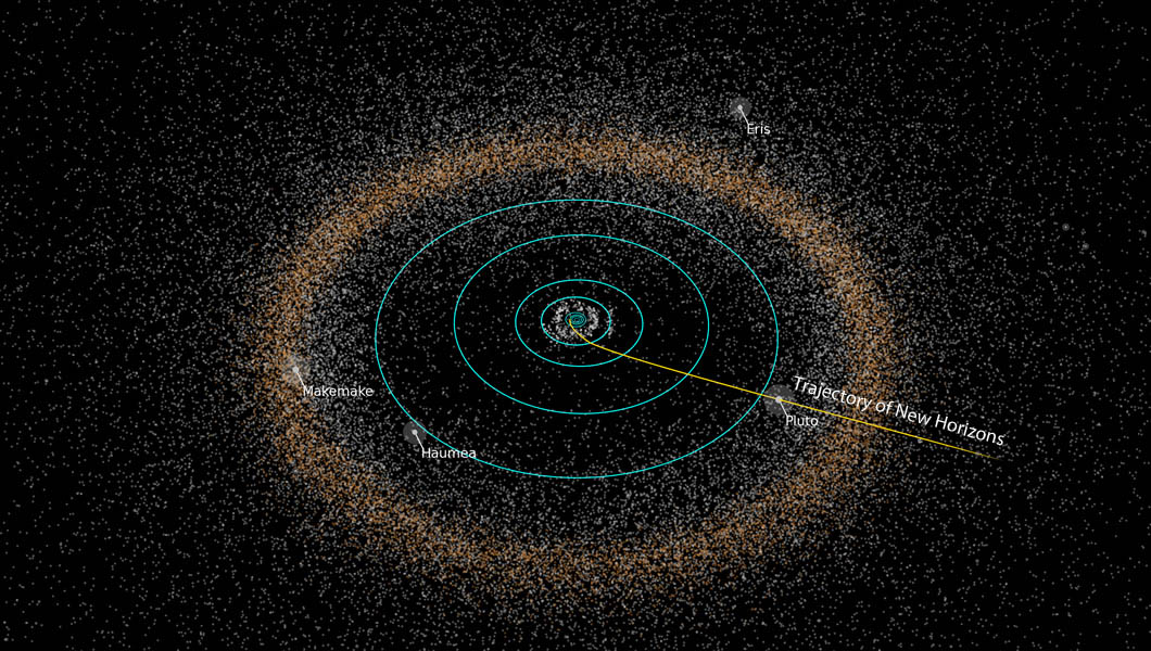
On July 14th, 2015, the New Horizons mission made history by conducting the first flyby of Pluto. This represented the culmination of a nine year journey, which began on January 19th, 2006 – when the spacecraft was launched from the Cape Canaveral Air Force Station. And before the mission is complete, NASA hopes to send the spacecraft to investigate objects in the Kuiper Belt as well.
To mark the 11th anniversary of the spacecraft’s launch, members of the New Horizons team took part in panel a discussion hosted by the Johns Hopkins University Applied Physics Laboratory (JHUAPL) located in Laurel, Maryland. The event was broadcasted on Facebook Live, and consisted of team members speaking about the highlights of the mission and what lies ahead for the NASA spacecraft.
The live panel discussion took place on Thursday, Sept. 19th at 4 p.m. EST, and included Jim Green and Alan Stern – the director the Planetary Science Division at NASA and the principle investigator (PI) of the New Horizons mission, respectively. Also in attendance was Glen Fountain and Helene Winters, New Horizons‘ project managers; and Kelsi Singer, the New Horizons co-investigator.
Artist’s concept of the New Horizons spacecraft encountering a Kuiper Belt object, part of an extended mission after the spacecraft’s July 2015 Pluto flyby. Credits: NASA/JHUAPL/SwRI
In the course of the event, the panel members responded to questions and shared stories about the mission’s greatest accomplishments. Among them were the many, many high-resolution photographs taken by the spacecraft’s Ralph and Long Range Reconnaissance Imager (LORRI) cameras. In addition to providing detailing images of Pluto’s surface features, they also allowed for the creation of the very first detailed map of Pluto.
Though Pluto is not officially designated as a planet anymore – ever since the XXVIth General Assembly of the International Astronomical Union, where Pluto was designated as a “dwarf planet” – many members of the team still consider it to be the ninth planet of the Solar System. Because of this, New Horizons‘ historic flyby was of particular significance.
As Principle Investigator Alan Stern – from the Southwestern Research Institute (SwRI) – explained in an interview with Inverse, the first phase of humanity’s investigation of the Solar System is now complete. “What we did was we provided the capstone to the initial exploration of the planets,” he said. “All nine have been explored with New Horizons finishing that task.”
Other significant discoveries made by the New Horizons mission include Pluto’s famous heart-shaped terrain – aka. Sputnik Planum. This region turned out to be a young, icy plain that contains water ice flows adrift on a “sea” of frozen nitrogen. And then there was the discovery of the large mountain and possible cryovolcano located at the tip of the plain – named Tombaugh Regio, (in honor of Pluto’s discovered, Clyde Tombaugh).
New Horizons path from the inner Solar System to Pluto and the Kuiper Belt. Credit: NASA/JHUAPL
The mission also revealed further evidence of geological activity and cryovolcanism, the presence of hyrdocarbon clouds on Pluto, and conducted the very first measurements of how Pluto interacts with solar wind. All told, over 50 gigabits of data were collected by New Horizons during its encounter and flyby with Pluto. And the detailed map which resulted from it did a good job of capturing all this complexity and diversity. As Stern explained:
“That really blew away our expectations. We did not think that a planet the size of North America could be as complex as Mars or even Earth. It’s just tons of eye candy. This color map is the highest resolution we will see until another spacecraft goes back to Pluto.”
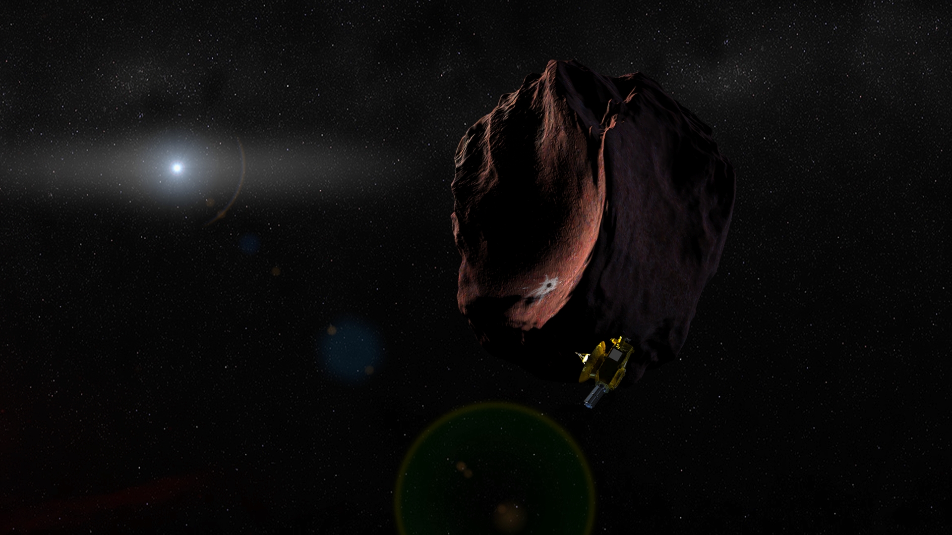
After making its historic flyby of Pluto, the New Horizons team requested that the mission receive an extension to 2021 so that it could explore Kuiper Belt Objects (KBOs). This extension was granted, and for the first part of the Kuiper Belt Extended Mission (KEM), the spacecraft will perform a close flyby of the object known as 2014 MU69.
This remote KBO – which is estimated to be between 25 – 45 km (16-28 mi) in diameter – was one of two objects identified as potential targets for research, and the one recommended by the New Horizons team. The flyby, which is expected to take place in January of 2019, will involve the spacecraft taking a series of photographs on approach, as well as some pictures of the object’s surface once it gets closer.
Before the extension ends in 2021, it will continue to send back information on the gas, dust and plasma conditions in the Kuiper Belt. Clearly, we are not finished with the New Horizons mission, and it is not finished with us!
A beautiful ISS transit on June 19 2015 recorded at Biscarrosse, France. Credit: David Duarte
What strange creature is this flitting across the Moon? Several members of the European Space Agency’s Astronomy Center captured these views of the International Space Station near Madrid, Spain on January 14 as it flew or transited in front of the full moon. Credit: Michel Breitfellner, Manuel Castillo, Abel de Burgos and Miguel Perez Ayucar / ESA
One-one thou… That’s how long it takes for the International Space Station, traveling at over 17,000 mph (27,300 kph), to cross the face of the Full Moon. Only about a half second! To see it with your own eyes, you need to know exactly when and where to look. Full Moon is best, since it’s the biggest the moon can appear, but anything from a half-moon up and up will do.
The photo above was made by superimposing 13 separate images of the ISS passing in front of the Moon into one. Once the team knew when the pass would happen, they used a digital camera to fire a burst of exposures, capturing multiple moments of the silhouetted spacecraft.
The ISS transits the Full Moon in May 2016
The ISS is the largest structure in orbit, spanning the size of a football field, but at 250 miles (400 km) altitude, it only appears as big as a modest lunar crater. While taking a photo sequence demands careful planning, seeing a pass is bit easier. As you’d suspect, the chances of the space station lining up exactly with a small target like the Moon from any particular location is small. But the ISS Transit Findermakes the job simple.
This is a screen grab from the homepage of Bartosz Wojczy?ski’s most useful ISS Transit Finder. Credit: Bartosz Wojczy?ski
Click on the link and fill in your local latitude, longitude and altitude or select from the Google maps link shown. You can always find your precise latitude and longitude at NASA’s Latitude/Longitude Finderand altitude at Google Maps Find Altitude. Next, set the time span of your Moon transit search (up to one month from the current date) and then how far you’re willing to drive to see the ISS fly in front of the Moon.
When you click Calculate, you’ll get a list of events with little diagrams showing where the ISS will pass in relation to the Moon and sun (yes, the calculator also does solar disk crossings!) from your location. Notice that most of the passes will be near misses. However, if you click on the Show on Map link, you’ll get a ground track of exactly where you will need to travel to see it squarely cross Moon or Sun. Times shown are your local time, not Universal or UT.
A beautiful ISS transit on June 19 2015 recorded at Biscarrosse, France. The photographer used CalSky, another excellent satellite site, to prepare a week in advance of the event. This composite image was made with a Canon EOS 60D. Notice how bright the space station appears against the moon due to the lower-angled lighting across the lunar landscape at crescent phase compared to full, when the ISS appears in silhouette. Credit: David Duarte
The map also includes Recalculate for this location link. Clicking that will show you a sketch of the ISS’ predicted path across the Moon from the centerline location along with other details. I checked my city, and while there are no lunar transits for the next month, there’s a very nice solar one visible just a few miles from my home on Feb. 8. Remember to use a safe solar filter if you plan on viewing one of these!
The ISS transits the Sun on May 3, 2016. Click for details on how the photo was taken. Credit: Szabolcs Nagy
While you might attempt to see a transit of the ISS in binoculars, your best bet is with a telescope. Nothing fancy required, just about any size will do so long as it magnifies at least 30x to 40x. Timing is crucial. Like an occultation, when the moon hides a background star in an instant, you want to be on time and 100% present.
Make sure you’re set up and focused on the moon or sun (with filter) at least 5 minutes beforehand. Keep your cellphone handy. I’ve found the time displayed at least on my phone to be accurate. One minute before the anticipated transit, glue your eye to the eyepiece, relax and wait for the flyby. Expect something like a bird in silhouette to make a swift dash across the moon’s face. The video above will help you anticipate what to expect.
The next lunar transit nearest my home is an hour and a half away in the small town of Biwabik, Minn. according to the ISS Transit Finder. On Jan. 30 at 8:00:08 p.m local time, the ISS will cross the crescent moon from there. Once you know the time of the prediction and the exact latitude and longitude of the location (all information shown in the info box on the map using the ISS Transit Finder), you can turn on the satellites feature in the free Stellarium program (stellarium.org), select the ISS and create a simulated, detailed path. Created with Stellarium
Even if you never go to the trouble of identifying a “direct hit”, you can still use the transit finder to compile a list of cool lunar close approaches that would make for great photos with just a camera and tripod.
The Transit Finder isn’t the only way to predict ISS flybys. Some observers also use the excellent satellite site, CalSky. Once you tell it your location, select the Lunar/Solar Disk Crossings and Occultations link for lots of information including times, diagrams of crossings, ground tracks and more.
I use Stellarium (above) to make nifty simulated paths and show me where the Moon will be in the sky at the time of the transit. When you’ve downloaded the free program, get the latest satellite orbital elements this way:
* Move you cursor to the lower left of the window and select the Configuration box
* Click the Plugins tab and scroll down to Satellites and click Configure and then Update
* Hover the cursor at the bottom of the screen for a visual menu. Slide over to the satellite icon and click it once for Satellite hints. The ISS will now be active.
* Set the clock and location (lower left again) for the precise time and location, then do a search for the Moon, and you’ll see the ISS path.
There you have it — lots of options. Or you can simply use the Transit Finder and call it a day! I hope you’ll soon be in the right place at the right time to see the space station pass in front of the Moon. Checking my usual haunts, I see that the space station will be returning next weekend (Jan. 27) to begin an approximately 3-week run of easily viewable evening passes.