A Day on Earth Used to Only Be 19 Hours

Meteosat
A full disk view of the Earth, courtesy of Meteosat-I 1. Credit: ESA/Meteosat

On Earth, a single solar day lasts 24 hours. That is the time it takes for the Sun to return to the same place in the sky as the day before. The Moon, Earth’s only natural satellite, takes about 27 days to complete a single circuit around our planet and orbits at an average distance of 384,399 km (~238,854.5 mi). Since time immemorial, humans have kept track of the Sun, the Moon, and their sidereal and synodic periods. To the best of our knowledge, the orbital mechanics governing the Earth-Moon system have been the same, and we’ve come to take them for granted.

But there was a time when the Moon orbited significantly closer to Earth, and the average day was much shorter than today. According to a recent study by a pair o researchers from China and Germany, an average day lasted about 19 hours for one billion years during the Proterozoic Epoch – a geological period during the Precambrian that lasted from 2.5 billion years to 541 million years ago. This demonstrates that rather than gradually increasing over time (as previously thought), the length of a day on Earth remained constant for an extended period.

Continue reading “A Day on Earth Used to Only Be 19 Hours”

What are You Doing With Your Added Leap Second Today?

Everyone loves a long weekend, this weekend will be officially one second longer than usual. An extra second, or “leap” second, will be added at midnight UTC tonight, June 30, 2012, to account for the fact that it is taking Earth longer and longer to complete one full turn, or one a solar day. Granted, it the additional time is not very long, but the extra second will ensure that the atomic clocks we use to keep time will be in synch with Earth’s rotational period.

“The solar day is gradually getting longer because Earth’s rotation is slowing down ever so slightly,” says Daniel MacMillan of NASA’s Goddard Space Flight Center.

So, rather than changing from 23:59:59 on June 30 to 00:00:00 on July 1, the official time will get an extra second at 23:59:60.

About every one and a half years, one extra second is added to Universal Coordinated Time (UTC) and clocks around the world. Since 1972, a total of 24 seconds have been added. This means that the Earth has slowed down 24 seconds compared to atomic time since then.

However, this doesn’t mean that days are 24 seconds longer now, as only the days on which the leap seconds are inserted have 86,401 seconds instead of the usual 86,400 seconds.

This leap second accounts for the fact that the Earth’s rotation around its own axis, which determines the length of a day, slows down over time while the atomic clocks we use to measure time tick away at almost the same speed over millions of years.

NASA explains it this way:

Scientists know exactly how long it takes Earth to rotate because they have been making that measurement for decades using an extremely precise technique called Very Long Baseline Interferometry (VLBI). VLBI measurements are made daily by an international network of stations that team up to conduct observations at the same time and correlate the results. NASA Goddard provides essential coordination of these measurements, as well as processing and archiving the data collected. And NASA is helping to lead the development of the next generation of VLBI system through the agency’s Space Geodesy Project, led by Goddard.

From VLBI, scientists have learned that Earth is not the most reliable timekeeper. The planet’s rotation is slowing down overall because of tidal forces between Earth and the moon. Roughly every 100 years, the day gets about 1.4 milliseconds, or 1.4 thousandths of a second, longer. Granted, that’s about 100 or 200 times faster than the blink of an eye. But if you add up that small discrepancy every day for years and years, it can make a very big difference indeed.

“At the time of the dinosaurs, Earth completed one rotation in about 23 hours,” says MacMillan, who is a member of the VLBI team at NASA Goddard. “In the year 1820, a rotation took exactly 24 hours, or 86,400 standard seconds. Since 1820, the mean solar day has increased by about 2.5 milliseconds.”

By the 1950s, scientists had already realized that some scientific measurements and technologies demanded more precise timekeeping than Earth’s rotation could provide. So, in 1967, they officially changed the definition of a second. No longer was it based on the length of a day but on an extremely predictable measurement made of electromagnetic transitions in atoms of cesium. These “atomic clocks” based on cesium are accurate to one second in 1,400,000 years. Most people around the world rely on the time standard based on the cesium atom: Coordinated Universal Time (UTC).

Another time standard, called Universal Time 1 (UT1), is based on the rotation of Earth on its axis with respect to the sun. UT1 is officially computed from VLBI measurements, which rely on astronomical reference points and have a typical precision of 5 microseconds, or 5 millionths of a second, or better.

“These reference points are very distant astronomical objects called quasars, which are essentially motionless when viewed from Earth because they are located several billion light years away,” says Goddard’s Stephen Merkowitz, the Space Geodesy Project manager.

For VLBI observations, several stations around the world observe a selected quasar at the same time, with each station recording the arrival of the signal from the quasar; this is done for a series of quasars during a typical 24-hour session. These measurements are made with such exquisite accuracy that it’s actually possible to determine that the signal does not arrive at every station at exactly the same time. From the miniscule differences in arrival times, scientists can figure out the positions of the stations and Earth’s orientation in space, as well as calculating Earth’s rotation speed relative to the quasar positions.

Originally, leap seconds were added to provide a UTC time signal that could be used for navigation at sea. This motivation has become obsolete with the development of GPS (Global Positioning System) and other satellite navigation systems. These days, a leap second is inserted in UTC to keep it within 0.9 seconds of UT1.

Normally, the clock would move from 23:59:59 to 00:00:00 the next day. Instead, at 23:59:59 on June 30, UTC will move to 23:59:60, and then to 00:00:00 on July 1. In practice, this means that clocks in many systems will be turned off for one second.

Proposals have been made to abolish the leap second and let the two time standards drift apart. This is because of the cost of planning for leap seconds and the potential impact of adjusting or turning important systems on and off in synch. No decision will made about that, however, until 2015 at the earliest by the International Telecommunication Union, a specialized agency of the United Nations that addresses issues in information and communication technologies. If the two standards are allowed to go further and further out of synch, they will differ by about 25 minutes in 500 years.

In the meantime, leap seconds will continue to be added to the official UTC timekeeping. The 2012 leap second is the 35th leap second to be added and the first since 2008.

Lead image credit: Rick Ellis

Sources: NASA, TimeandDate.com

Angular Velocity of Earth

Angular Velocity of Earth
This view of Earth comes from NASA's Moderate Resolution Imaging Spectroradiometer aboard the Terra satellite

[/caption]
The planet Earth has three motions: it rotates about its axis, which gives us day and night; it revolves around the sun, giving us the seasons of the year, and through the Milky Way along with the rest of the Solar System. In each case, scientists have striven to calculate not only the time it takes, but the relative velocities involved. When it comes to the Earth rotating on its axis, a process which takes 23 hours, 56 minutes and 4.09 seconds, the process is known as a sidereal day, and the speed at which it moves is known as the Earth’s Angular Velocity. This applies equally to the Earth rotating around the axis of the Sun and the center of the Milky Way Galaxy.

In physics, the angular velocity is a vector quantity which specifies the angular speed of an object and the axis about which the object is rotating. The SI unit of angular velocity is radians per second, although it may be measured in other units such as degrees per second, revolutions per second, etc. and is usually represented by the symbol omega (ω, rarely Ω). A radian, by definition, is a unit which connects the radius of an arc, the length of the arc and the angle subtended by the arc. A full radian is 360 degrees, hence we know that the Earth performs two radians when performing a full rotation around an axis. However, it is sometimes also called the rotational velocity and its magnitude – the rotational speed – is typically measured in cycles or rotations per unit time (e.g. revolutions per minute). In addition, when an object rotating about an axis, every point on the object has the same angular velocity.

Mathematically, the average angular velocity of an object can be represented by the following equation: ωaverage= Δθ/Δt, where ω is the radians/revolutions per second (on average), Δ is the change in quantity, θ is the velocity, and t is time. When calculating the angular velocity of the Earth as it completes a full rotation on its own axis (a solar day), this equation is represented as: ωavg = 2πrad/1day (86400 seconds), which works out to a moderate angular velocity of 7.2921159 × 10⁻⁵ radians/second. In the case of a Solar Year, where ωavg = 2πrad/1year (3.2×10⁷ seconds), we see that the angular velocity works out to 2.0×10⁻⁷ rad/s.

We have written many articles about the angular velocity of Earth for Universe Today. Here’s an article about angular velocity, and here’s an article about why the Earth rotates.

If you’d like more info on angular velocity of Earth, check out the following articles:
Angular Speed of Earth
Earth’s Rotation

We’ve also recorded an episode of Astronomy Cast all about planet Earth. Listen here, Episode 51: Earth.

Sources:
http://en.wikipedia.org/wiki/Angular_velocity
http://hyperphysics.phy-astr.gsu.edu/hbase/rotq.html
http://hypertextbook.com/facts/2002/JasonAtkins.shtml
http://en.wikipedia.org/wiki/Earth%27s_rotation#Rotation_period
http://www.livephysics.com/tables-of-physical-data/mechanical/angular-speed-of-earth.html

Solar Day

Winter Solstice
Earth as viewed from the cabin of the Apollo 11 spacecraft. Credit: NASA

[/caption]

Since the dawn of time, human beings have relied on the cycles of the sun, the moon, and the constellations through the zodiac in order to measure time. The most basic of these was the motion of the Sun as it traced an apparent path through the sky, beginning in the East and ending in the West. This procession, by definition, is what is known as a Solar Day. Originally, it was thought that this motion was the result of the Sun moving around the Earth, much like the Moon, celestial objects and stars seemed to do. However, beginning with Copernicus’ heliocentric model, it has since been known that this motion is due to the daily rotation of the earth around the Sun’s polar axis.

Up until the 1950’s, two types of Solar time were used by astronomers to measure the days of the year. The first, known as Apparent Solar Time, is measured in accordance with the observable motion of the Sun as it moves through the sky (hence the term apparent). The length of a solar day varies throughout the year, a result of the Earth’s elliptical orbit and axial tilt. In this model, the length of the day varies and the accumulated effect is a seasonal deviation of up to 16 minutes from the mean. The second type, Solar Mean Time, was devised as a way of resolving this conflict. Conceptually, Mean solar time is based on a fictional Sun that is considered to move at a constant rate of 360° in 24 hours along the celestial meridian. One mean day is 24 hours in length, each hour consisting of 60 minutes, and each minute consisting of 60 seconds. Though the amount of daylight varies significantly throughout the year, the length of a mean solar day is kept constant, unlike that of an apparent solar day.

The measure of time in both of these models depends on the rotation of the Earth. In both models, the time of day is not plotted based on the position of the Sun in the sky, but on the hour angle that it produces – i.e. the angle through which the earth would have to turn to bring the meridian of the point directly under the sun. Nowadays both kinds of solar time stand in contrast to newer kinds of time measurement, introduced from the 1950s and onwards which were designed to be independent of earth rotation.

We have written many articles about Solar Day for Universe Today. Here’s an article about how long a day is on Earth, and here’s an article about the rotation of the Earth.

If you’d like more info on Earth, check out NASA’s Solar System Exploration Guide on Earth. And here’s a link to NASA’s Earth Observatory.

We’ve also recorded an episode of Astronomy Cast all about planet Earth. Listen here, Episode 51: Earth.

Sources:
http://en.wikipedia.org/wiki/Solar_time
http://www.tpub.com/content/administration/14220/css/14220_149.htm
http://scienceworld.wolfram.com/astronomy/SolarDay.html
http://www.britannica.com/EBchecked/topic/553052/solar-time?anchor=ref144523
http://en.wikipedia.org/wiki/Hour_angle

What Is the Coriolis Effect

Coriolis Effect
Coriolis Effect

[/caption]

The Coriolis effect is one of those terms that you hear used from time to time, but it never seems to get fully explained, so you are left wondering ‘what is the Coriolis effect?’ The Coriolis effect is the apparent curvature of global winds, ocean currents, and everything else that moves freely across the Earth’s surface. The curvature is due to the rotation of the Earth on its axis. The effect was discovered by the nineteenth century French engineer Gaspard C. Coriolis. He used mathematical formulas to explain that the path of any object set in motion above a rotating surface will curve in relation to objects on that surface.

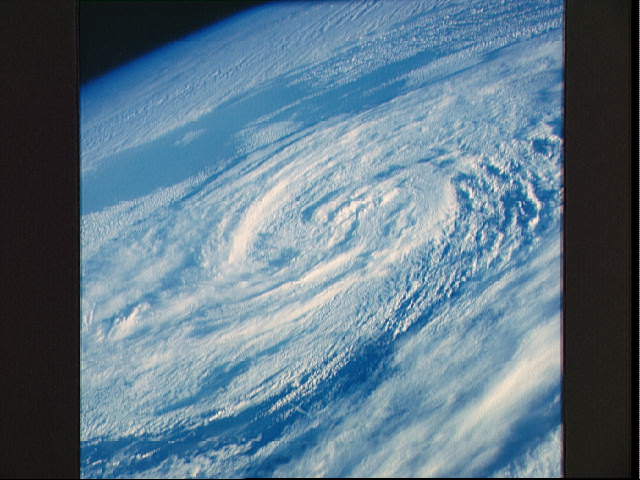
If not for the Earth’s rotation, global winds would blow in straight north-south lines. What actually happens is that global winds blow diagonally. The Coriolis effect influences wind direction around the world in this way: in the Northern Hemisphere it curves winds to the right; in the Southern Hemisphere it curves them left. The exception is with low pressure systems. In these systems there is a balance between the Coriolis effect and the pressure gradient force and the winds flow in reverse.

Satellites appear to follow curved paths when plotted on world maps because the Earth is a sphere and the shortest distance between two points on a sphere is not a straight line. Two-dimensional maps distort a three-dimensional surface in some way. The distortion increases with closer to the poles. In the northern hemisphere a satellite’s orbit using the shortest possible route will appear to follow a path north of the straight line from beginning to end, and then curve back toward the equator. This occurs because the latitudes, which are projected as straight horizontal lines on most world maps, are in fact circles on the surface of a sphere, which get smaller as they get closer to the pole. This happens simply because the Earth is a sphere and would be true if the Earth didn’t rotate. The Coriolis effect is of course also present, but its effect on the plotted path is much smaller, but increases in importance when calculating a trajectory or end destination. The effect becomes very important when you need to plot trajectories for missiles or artillery fire.

To sum up ‘what is the Coriolis effect’, it is an important meteorological force that is used to predict the path of storms and explains why a projectile will not hit a target at a great distance if the Earth’s rotation is not accounted for.

We have written many articles about Coriolis Effect for Universe Today. Here’s an article about the hurricane, and here’s an article about the Earth’s rotation.

If you’d like more info on Coriolis Effect, check out NASA’s Solar System Exploration Guide on Earth. And here’s a link to NASA’s Earth Observatory.

We’ve also recorded an episode of Astronomy Cast all about planet Earth. Listen here, Episode 51: Earth.

Sources:
University of Oregon
Wikipedia
NASA

What is the Diameter of Earth?

Our beautiful, precious, life-supporting Earth as seen on July 6, 2015 from a distance of one million miles by a NASA scientific camera aboard the Deep Space Climate Observatory spacecraft. Credits: NASA

For those people who have had the privilege of jet-setting or traveling the globe, its pretty obvious that the world is a pretty big place. When you consider how long it took for human beings to settle every corner of it (~85,000 years, give or take a decade) and how long it took us to explored and map it all out, terms like “small world” cease to have any meaning.

But to complicate matters a little, the diameter of Earth – i.e. how big it is from one end to the other – varies depending on where you are measuring from. Since the Earth is not a perfect sphere, it has a different diameter when measured around the equator than it does when measured from the poles. So what is the Earth’s diameter, measured one way and then the other?

Oblate Spheroid:

Thanks to improvements made in the field of astronomy by the 17th and 18th centuries  – as well as geodesy, a branch of mathematics dealing with the measurement of the Earth – scientists have learned that the Earth is not a perfect sphere. In truth, it is what is known as an “oblate spheroid”, which is a sphere that experiences flattening at the poles.

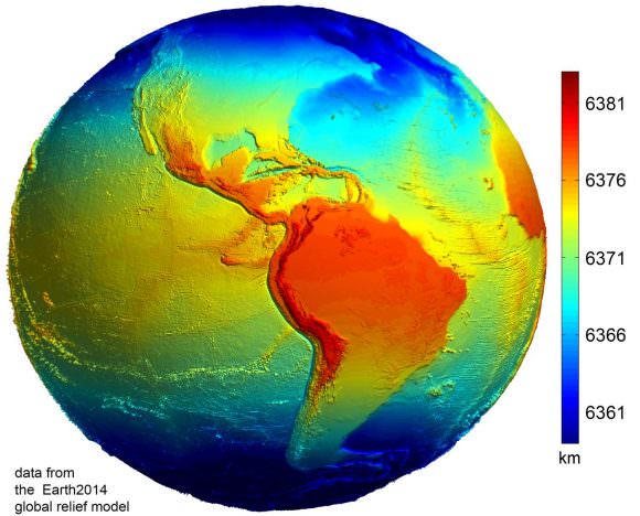
Data from the Earth2014 global relief model, with distances in distance from the geocentre denoted by color. Credit: Geodesy2000

According to the 2004 Working Group of the International Earth Rotation and Reference Systems Service (IERS), Earth experiences a flattening of 0.0033528 at the poles. This flattening is due to Earth’s rotational velocity – a rapid 1,674.4 km/h (1,040.4 mph) – which causes the planet to bulge at the equator.

Equatorial vs Polar Diameter:

Because of this, the diameter of the Earth at the equator is about 43 kilometers (27 mi) larger than the pole-to-pole diameter. As a result, the latest measurements indicate that the Earth has an equatorial diameter of 12,756 km (7926 mi), and a polar diameter of 12713.6 km (7899.86 mi).

In short, objects located along the equator are about 21 km further away from the center of the Earth (geocenter) than objects located at the poles. Naturally, there are some deviations in the local topography where objects located away from the equator are closer or father away from the center of the Earth than others in the same region.

The most notable exceptions are the Mariana Trench – the deepest place on Earth, at 10,911 m (35,797 ft) below local sea level – and Mt. Everest, which is 8,848 meters (29,029 ft) above local sea level. However, these two geological features represent a very minor variation when compared to Earth’s overall shape – 0.17% and 0.14% respectively.

Meanwhile, the highest point on Earth is Mt. Chiborazo. The peak of this mountain reaches an attitude of 6,263.47 meters (20,549.54 ft) above sea level. But because it is located just 1° and 28 minutes south of the equator (at the highest point of the planet’s bulge), it receives a natural boost of about 21 km.

Mean Diameter:

Because of the discrepancy between Earth’s polar and equatorial diameter, astronomers and scientists often employ averages. This is what is known as its “mean diameter”, which in Earth’s case is the sum of its polar and equatorial diameters, which is then divided in half. From this, we get a mean diameter of 12,742 km (7917.5 mi).

The difference in Earth’s diameter has often been important when it comes to planning space launches, the orbits of satellites, and when circumnavigating the globe. Given that it takes less time to pass over the Arctic or Antarctica than it does to swing around the equator, sometimes this is the preferred path.

We have written many interesting articles about the Earth and mountains here at Universe Today. Here’s Planet Earth, The Rotation of the Earth, What is the Highest Point on Earth?, and Mountains: How Are They Formed?

Here’s how the diameter of the Earth was first measured, thousands of years ago. And here’s NASA’s Earth Observatory.

We did an episode of Astronomy Cast just on the Earth. Give it a listen, Episode 51: Earth.

Sources: