1981 Climate Change Predictions Were Eerily Accurate

The disintegrated Wilkins Ice Shelf in April 2009. (Chelys/EOSnap)

[/caption]

A paper published in the journal Science in August 1981 made several projections regarding future climate change and anthropogenic global warming based on manmade CO2 emissions. As it turns out, the authors’  projections have proven to be rather accurate — and their future is now our present.

The paper, written by a team of atmospheric physicists led by the now-controversial James Hansen at NASA’s Institute for Space Studies at Goddard Space Flight Center, was recently rediscovered by researchers Geert Jan van Oldenborgh and Rein Haarsma from the Royal Netherlands Meteorological Institute (KNMI). Taking a break from research due to illness, the scientists got a chance to look back through some older, overlooked publications.

“It turns out to be a very interesting read,” they noted in their blog on RealClimate.org.

Even though the paper was given 10 pages in Science, it covers a lot of advanced topics related to climate — indicating the level of knowledge known about climate science even at that time.

“The concepts and conclusions have not changed all that much,” van Oldenborgh and Haarsma note. “Hansen et al clearly indicate what was well known (all of which still stands today) and what was uncertain.”

Within the paper, several graphs note the growth of atmospheric carbon dioxide, both naturally occurring and manmade, and projected a future rise based on the continued use of fossil fuels by humans. Van Oldenborgh and Haarsma overlaid data gathered by NASA and KNMI in recent years and found that the projections made by Hansen et al. were pretty much spot-on.

If anything, the 1981 projections were “optimistic”.

Data from the GISS Land-Ocean Temperature Index fit rather closely with the 1981 projection (van Oldenborgh and Haarsma)

Hansen wrote in the original paper:

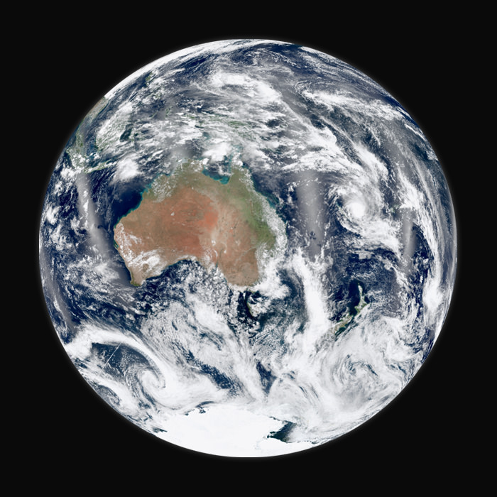
“The global temperature rose by 0.2ºC between the middle 1960’s and 1980, yielding a warming of 0.4ºC in the past century. This temperature increase is consistent with the calculated greenhouse effect due to measured increases of atmospheric carbon dioxide. Variations of volcanic aerosols and possibly solar luminosity appear to be primary causes of observed fluctuations about the mean rend of increasing temperature. It is shown that the anthropogenic carbon dioxide warming should emerge from the noise level of natural climate variability by the end of the century, and there is a high probability of warming in the 1980’s. Potential effects on climate in the 21st century include the creation of drought-prone regions in North America and central Asia as part of a shifting of climate zones, erosion of the West Antarctic ice sheet with a consequent worldwide rise in sea level, and opening of the fabled Northwest Passage.”

Now here we are in 2012, looking down the barrel of the global warming gun Hansen and team had reported was there 31 years earlier. In fact, we’ve already seen most of the predicted effects take place.

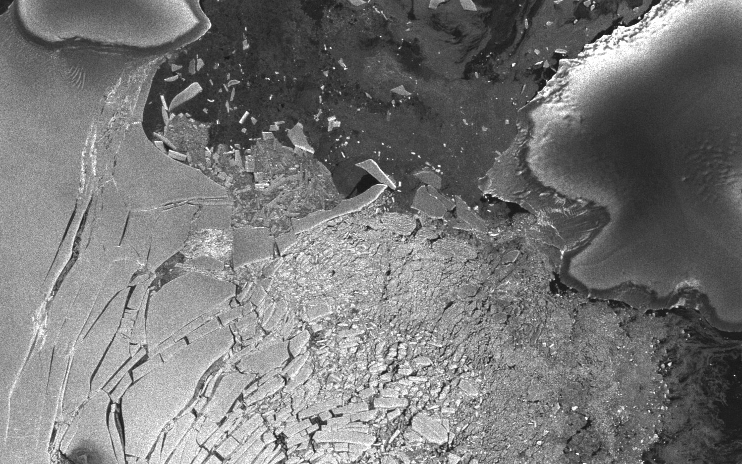
“Drought-prone regions” are receiving less rainfall, the Antarctic ice has begun to crack and crumble and bowhead whales are using the Northwest Passage as a polar short-cut. 

The retreat of Pedersen Glacier in Alaska. Left: summer 1917. Right: summer 2005. Source: The Glacier Photograph Collection, National Snow and Ice Data Center/World Data Center for Glaciology.

And that’s not the only prediction that seems to have uncannily come true.

“In light of historical evidence that it takes several decades to complete a major change in fuel use, this makes large climate change almost inevitable,” Hansen et al wrote in anticipation of the difficulties of a global shift away from dependence on carbon dioxide-emitting fossil fuels.

“CO2 effects on climate may make full exploitation of coal resources undesirable,” the paper concludes. “An appropriate strategy may be to encourage energy conservation and develop alternative energy sources, while using fossil fuels as necessary during the next few decades.”

(Watch a TED talk by James Hansen on “Why I Must Speak Out About Climate Change”)

As the “next few decades” are now, for us, coming to a close, where do we stand on the encouragement of energy conservation and development on alternative energy sources?  Sadly the outlook is not as promising as it should be, not given our level of abilities to monitor the intricate complexities of our planet’s climate and to develop new technologies. True advancement will rely on our acceptance that a change is in fact necessary… a hurdle that is proving to be the most difficult one to clear.

Read van Oldenborgh and Haarsma’s blog post here, and see the full 1981 paper “Climate Impact of Increasing Carbon Dioxide” here. And for more news on our changing climate, visit NASA’s Global Climate Change site.

Tip of the anthropogenically-warmer hat to The Register.

Is Earth Running Out Of Crust?

Panorama of a volcanic crater on Kilauea. (USGS)

[/caption]

Earth just doesn’t make crust like it used to… at least, not according to new research by a team of scientists in the UK.

Researchers with the Universities of Bristol, St Andrews and Portsmouth have studied elements trapped within zircon samples gathered from all over the planet to peer billions of years back in time at how Earth’s crust was being produced.

Zircon, a mineral found in granite, can be dated with precision and is thus an accurate measure for geologic timescales.

What they found was that 65% of our planet’s current crust had already existed 3 billion years ago. Since rocks older than 2.5 billion years are rare on Earth today, this means that some process began to take place that either reworked — or destroyed — a large portion of the older crust, and changed how new crust was formed.

During the first 1.5 billion years of Earth’s history, the team reports, the rate of crust formation was high — approximately 3 cubic kilometers was added to the continents each year. After that the rate dropped substantially, falling to about 0.8 cubic kilometers per year for the next 3 billion years — right up to the present day.

The cause is yet unknown, but it may be the result of the onset of plate tectonics driven by subduction — the process by which sections of Earth’s crust (“plates”) slide beneath other sections, sinking into the underlying mantle to be liquefied into magma by pressure and heat. New crust is created when the magma rises again where the plates separate… Earth’s current “conveyor belt” of crust formation.

Whatever process was in place prior to 3 billion years ago, it was much more efficient at creating crust.

“Such a sharp decrease in the crustal growth rate about 3 billion years ago indicates a dramatic change in the way the continental crust was generated and preserved,” said Dr. Bruno Dhuime of the University of Bristol’s School of Earth Sciences. “This change may in turn be linked to the onset of subduction-driven plate tectonics and discrete subduction zones as observed at the present day.  The next challenge is to determine which tectonic regime shaped the Earth’s crust in the planet’s first 1.5 billion years before this change.”

The team’s paper “A Change in the Geodynamics of Continental Growth 3 Billion Years Ago” (Bruno Dhuime, Chris J. Hawkesworth,  Peter A. Cawood, Craig D. Storey) was published March 16 in Science.

Read more on the University of Bristol’s press release here.

Shaking Up Theories Of Earth’s Formation

Earth may not have formed quite like once thought (Image: NASA/Suomi NPP)

[/caption]

Researchers from The Australian National University are suggesting that Earth didn’t form as previously thought, shaking up some long-standing hypotheses of our planet’s origins right down to the core — literally.

Ian Campbell and Hugh O’Neill, both professors at ANU’s Research School for Earth Sciences, have challenged the concept that Earth formed from the same material as the Sun — and thus has a “chondritic” composition — an idea that has been assumed accurate by planetary scientists for quite some time.


Chondrite meteorites are composed of spherical chondrules, which formed in the solar nebula before the asteroids. (NASA)

Chondrites are meteorites that were formed from the solar nebula that surrounded the Sun over 4.6 billion years ago. They are valuable to scientists because of their direct relationship with the early Solar System and the primordial material they contain.

“For decades it has been assumed that the Earth had the same composition as the Sun, as long the most volatile elements like hydrogen are excluded,” O’Neill said. “This theory is based on the idea that everything in the solar system in general has the same composition. Since the Sun comprises 99 per cent of the solar system, this composition is essentially that of the Sun.”

Instead, they propose that our planet was formed through the collision of larger planet-sized bodies, bodies that had already grown massive enough themselves to develop an outer shell.

This scenario is supported by over 20 years of research by Campbell on columns of hot rock that rise from Earth’s core, called mantle plumes. Campbell discovered no evidence for “hidden reservoirs” of heat-producing elements such as uranium and thorium that had been assumed to exist, had Earth actually formed from chondritic material.

“Mantle plumes simply don’t release enough heat for these reservoirs to exist. As a consequence the Earth simply does not have the same composition as chondrites or the Sun,” Campbell said.

The outer shell of early Earth, containing heat-producing elements obtained from the impacting smaller planets, would have been eroded away by all the collisions.

“This produced an Earth that has fewer heat producing elements than chondritic meteorites, which explains why the Earth doesn’t have the same chemical composition,” O’Neill said.

The team’s paper has been published in the journal Nature. Read the press release from The Australian National University here.

1st Student Selected MoonKAM Pictures Look Inspiringly Home to Earth

Student-run MoonKAM Imager Looks Homeward. This image of the far side of the lunar surface, with Earth in the background, was taken by the MoonKAM system board the Ebb spacecraft as part of the first image set taken from lunar orbit from March 15 – 18, 2012. A little more than half-way up and on the left side of the image is the crater De Forest. Due to its proximity to the southern pole, DeForest receives sunlight at an oblique angle when it is on the illuminated half of the Moon. NASA/Caltech-JPL/MIT/SRS

[/caption]

The first student selected photos of the Moon’s surface snapped by NASA’s new pair of student named Lunar Mapping orbiters – Ebb & Flow – have just been beamed back and show an eerie view looking back to the Home Planet – and all of Humanity – barely rising above the pockmarked terrain of the mysterious far side of our nearest neighbor in space.

Congratulations to Americas’ Youth on an outstanding and inspiring choice !!

The student photo is reminiscent of one of the iconic images of Space Exploration – the first full view of the Earth from the Moon taken by NASA’s Lunar Orbiter 1 back in August 1966 (see below).

The images were taken in the past few days by the MoonKAM camera system aboard NASA’s twin GRAIL spacecraft currently circling overhead in polar lunar orbit, and previously known as GRAIL A and B. The formation-flying probes are soaring over the Moon’s north and south poles.

The nearly identical ships were rechristened as Ebb and Flow after Fourth grade students from the Emily Dickinson Elementary School in Bozeman, Mont., won the honor to rename both spacecraft by submitting the winning entries in a nationwide essay competition sponsored by NASA.

“The Bozeman 4th graders had the opportunity to target the first images soon after our science operations began,” said Maria Zuber, GRAIL principal investigator of the Massachusetts Institute of Technology in Cambridge, Mass., to Universe Today.

“It is impossible to overstate how thrilled and excited we are !”

The initial packet of some 66 student-requested digital images from the Bozeman kids were taken by the Ebb spacecraft from March 15-17 and downlinked to Earth March 20. They sure have lots of exciting classwork ahead analyzing all those lunar features !

“GRAIL’s science mapping phase officially began on March 6 and we are collecting science data,” Zuber stated.

Far Side of Moon Imaged by MoonKAM
This image of the lunar surface was taken by the MoonKAM system onboard NASA’s Ebb spacecraft on March 15, 2012. The 42.3-mile-wide (68-kilometer-wide) crater in the middle of the image (with the smaller crater inside) is Poinsot. Crater Poinsot, named for the French mathematician Louis Poinsot, is located on the northern part of the moon's far side. The target was selected by 4th grade students at Emily Dickinson Elementary School in Montana who had the honor of choosing the first MoonKAM images after winning a nationwide contest. NASA/Caltech-JPL/MIT/SRS

GRAIL’s science goal is to map our Moon’s gravity field to the highest precision ever. This will help deduce the deep interior composition, formation and evolution of the Moon and other rocky bodies such as Earth and also determine the nature of the Moon’s hidden core.

Engaging students and the public in science and space exploration plays a premier role in the GRAIL project. GRAIL is NASA’s first planetary mission to carry instruments – in the form of cameras – fully dedicated to education and public outreach.

Over 2,700 schools in 52 countries have signed up to participate in MoonKAM.

Ebb and Flow - New Names for the GRAIL Twins in Lunar Orbit
4th Grade Students from Bozeman, Montana (inset) won NASA’s contest to rename the GRAIL A and GRAIL B spacecraft and also chose the first lunar targets to be photographed by the onboard MoonKAM camera system. Artist concept of twin GRAIL spacecraft flying in tandem orbits around the Moon to measure its gravity field Credit: NASA/JPL -M ontage: Ken Kremer

5th to 8th grade students can send suggestions for lunar surface targets to the GRAIL MoonKAM Mission Operations Center at UC San Diego, Calif. Students will use the images to study lunar features such as craters, highlands, and maria while also learning about future landing sites.

NASA calls MoonKAM – “The Universe’s First Student-Run Planetary Camera”. MoonKAM means Moon Knowledge Acquired by Middle school students.

The MoonKAM project is managed by Dr Sally Ride, America’s first female astronaut.

“What might seem like just a cool activity for these kids may very well have a profound impact on their futures,” Ride said in a NASA statement. “The students really are excited about MoonKAM, and that translates into an excitement about science and engineering.”

“MoonKAM is based on the premise that if your average picture is worth a thousand words, then a picture from lunar orbit may be worth a classroom full of engineering and science degrees,” says Zuber. “Through MoonKAM, we have an opportunity to reach out to the next generation of scientists and engineers. It is great to see things off to such a positive start.”

MoonKAM image from NASA’s Ebb Lunar Mapping orbiter. This lunar target was selected by the 4th graders at Emily Dickinson Elementary School in Montana who won the contest to rename the GRAIL probes in a nationwide essay contest. NASA/Caltech-JPL/MIT/SRS

Altogether there are eight MoonKAM cameras aboard Ebb and Flow – one 50 mm lens and three 6 mm lenses. Each probe is the size of a washing machine and measures just over 3 feet in diameter and height.

Snapping the first images was delayed a few days by the recent series of powerful solar storms.

“Due to the extraordinary intensity of the storms we took the precaution of turning off the MoonKAMs until the solar flux dissipates a bit,” Zuber told me.

“GRAIL weathered the storm well. The spacecraft and instrument are healthy and we are continuing to collect science data.”

The washing-machine sized probes have been flying in tandem around the Moon since entering lunar orbit in back to back maneuvers over the New Year’s weekend. Engineers spent the past two months navigating the spaceship duo into lower, near-polar and near-circular orbits with an average altitude of 34 miles (55 kilometers) that are optimized for science data collection and simultaneously checking out the spacecraft systems.

Ebb and Flow were launched to the Moon on September 10, 2011 aboard a Delta II rocket from Cape Canaveral, Florida and took a circuitous 3.5 month low energy path to the moon to minimize the overall costs.

The Apollo astronauts reached the Moon in just 3 days. NASA’s next generation Orion space capsule currently under development will send American astronauts back to lunar orbit by 2021 or sooner.

NASA has just granted an extension to the GRAIL mission. Watch for my follow-up report detailing the expanded science goals of GRAIL’s extended lunar journey.

One of the first two remote images of Earth taken from the distance of the Moon on August 23, 1966 by NASA’s Lunar Orbiter 1 spacecraft. Credit: NASA

…….

March 24 (Sat): Free Lecture by Ken Kremer at the New Jersey Astronomical Association, Voorhees State Park, NJ at 830 PM. Topic: Atlantis, the End of Americas Shuttle Program, Orion, SpaceX, CST-100, Moon and the Future of NASA Human & Robotic Spaceflight

A Slice of Daybreak

An orbital dawn view from the ISS on Feb. 4, 2012

[/caption]

Here’s a gorgeous view from the International Space Station, taken by the Expedition 30 crew on Feb. 4, 2012 as the station passed into orbital dawn. The greens and reds of the aurora borealis shimmer above Earth’s limb beyond the Station’s solar panels as city lights shine beneath a layer of clouds.

As the ISS travels around the planet at 17,500 mph (28,163 km/h) it moves in and out of daylight, in effect experiencing dawn 16 times every day.

From that vantage point, 240 miles (386 km) above the Earth, the lights of the aurora — both northern and southern — appear below, rather than above.

See this and more images from the Space Station’s nightly flights here.

Also, here’s a time-lapse video made from photos taken by the Expedition 30 crew a few days earlier. Enjoy!

(Video courtesy of the Image Science & Analysis Laboratory, NASA Johnson Space Center.)

Far Above the World

Astronaut Bruce McCandless untethered above the Earth on Feb. 12, 1984. (NASA)

[/caption]

28 years ago today, NASA astronaut Bruce McCandless left the relative safety of Challenger’s payload bay and went untethered into orbit around Earth, venturing farther than anyone ever before.

The historic photo above was taken when McCandless was 320 feet from the orbiter — about the length of an American football field, or just shy of the width of the International Space Station.

The free-flying endeavor was possible because of McCandless’ nitrogen-powered jet-propelled backpack, called a Manned Maneuvering Unit (MMU). It attached to the space suit’s life-support system and was operated by hand controls, allowing untethered access to otherwise inaccessible areas of the orbiter and was also used in the deployment, service and retrieval of satellites.

Astronaut Dale Gardner using the MMU during STS-51A in Nov. 1984 to travel to the Westar VI satellite. (NASA)

The MMU used a non-contaminating nitrogen propellant that could be recharged in the orbiter. It weighed 140 kg (308 lbs) and has a built-in 35mm camera.

After the Challenger disaster, the MMU was deemed too risky and was discontinued. But for a brief period of time in the early ’80s, humans had the means for really “soaring to new heights”.

Image credits: NASA

New Computer Simulations Show Earth’s Spaghetti-Like Magnetosphere

Supercomputer simulation showing the tangled magnetosphere surrounding Earth. Credit: OLCF

[/caption]

A new computer simulation is showing Earth’s magnetosphere in amazing detail – and it looks a lot like a huge pile of tangled spaghetti (with the Earth as a meatball). Or perhaps a cosmic version of modern art.

The magnetosphere is formed by the Sun’s magnetic field interacting with Earth’s own magnetic field. When charged particles from a solar storm, also known as a coronal mass ejection (CME), impact our magnetic field, the results can be spectacular, from powerful electrical currents in the atmosphere to beautiful aurorae at high altitudes. Space physicists are using the new simulations to better understand the nature of our magnetosphere and what happens when it becomes extremely tangled.

Using a Cray XT5 Jaguar supercomputer, the physicists can better predict the effects of space weather, such as solar storms, before they actually hit our planet. According to Homa Karimabadi, a space physicist at the University of California-San Diego (UCSD), “When a storm goes off on the sun, we can’t really predict the extent of damage that it will cause here on Earth. It is critical that we develop this predictive capability.” He adds: “With petascale computing we can now perform 3D global particle simulations of the magnetosphere that treat the ions as particles, but the electrons are kept as a fluid. It is now possible to address these problems at a resolution that was well out of reach until recently.”

It helps that the radiation from solar storms can take 1-5 days to reach Earth, providing some lead time to assess the impact and any potential damage.

The previous studies were done using the Cray XT5 system known as Kraken; with the new Cray XT5 Jaguar supercomputer, they can perform simulations three times as large. The earlier simulations contained a “resolution” of about 1 billion individual particles, while the new ones contain about 3.2 trillion, a major improvement.

So next time you are eating that big plate of spaghetti, look up – the universe has its own recipes as well.

The original press release from Oak Ridge National Laboratory is here.