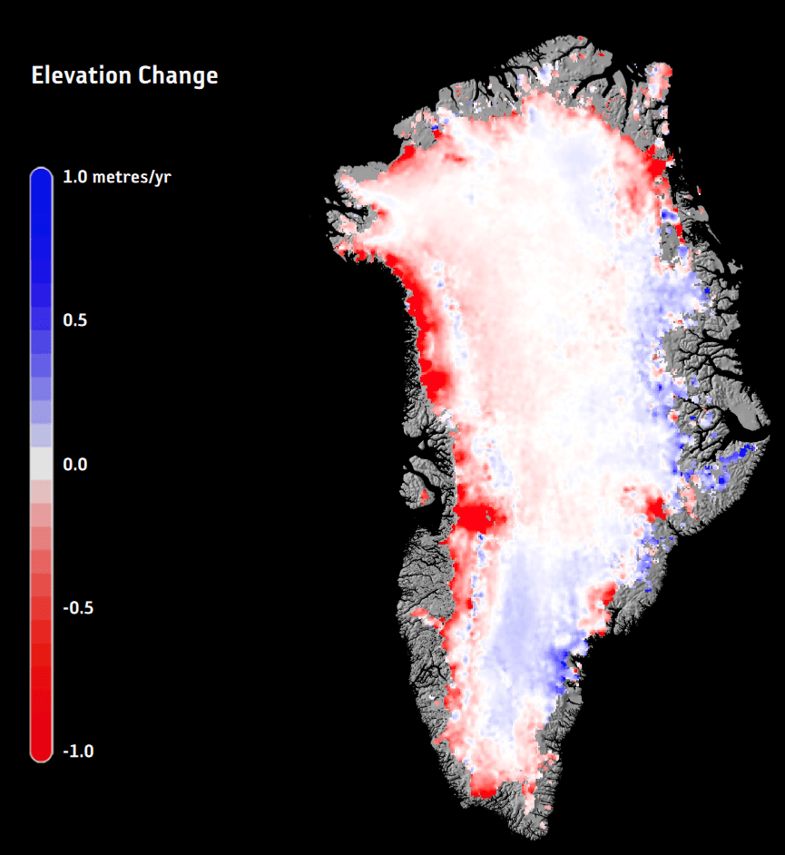
This image shows the change in Greenland ice thickness in just one year, 2015. Almost ten years have passed, Greenland is still melting, and our GHG emissions are still rising. Is it time to use geoengineering to stall the melting? Image Credit: ESA/Planetary Visions.
It’s time to take a thorough, more serious look at using geoengineering to protect the planet’s icesheets, according to a group of scientists who have released a new report examining the issue. Glacial geoengineering is an emerging field of study that holds some hope for Earth’s diminishing glaciers and ice sheets.
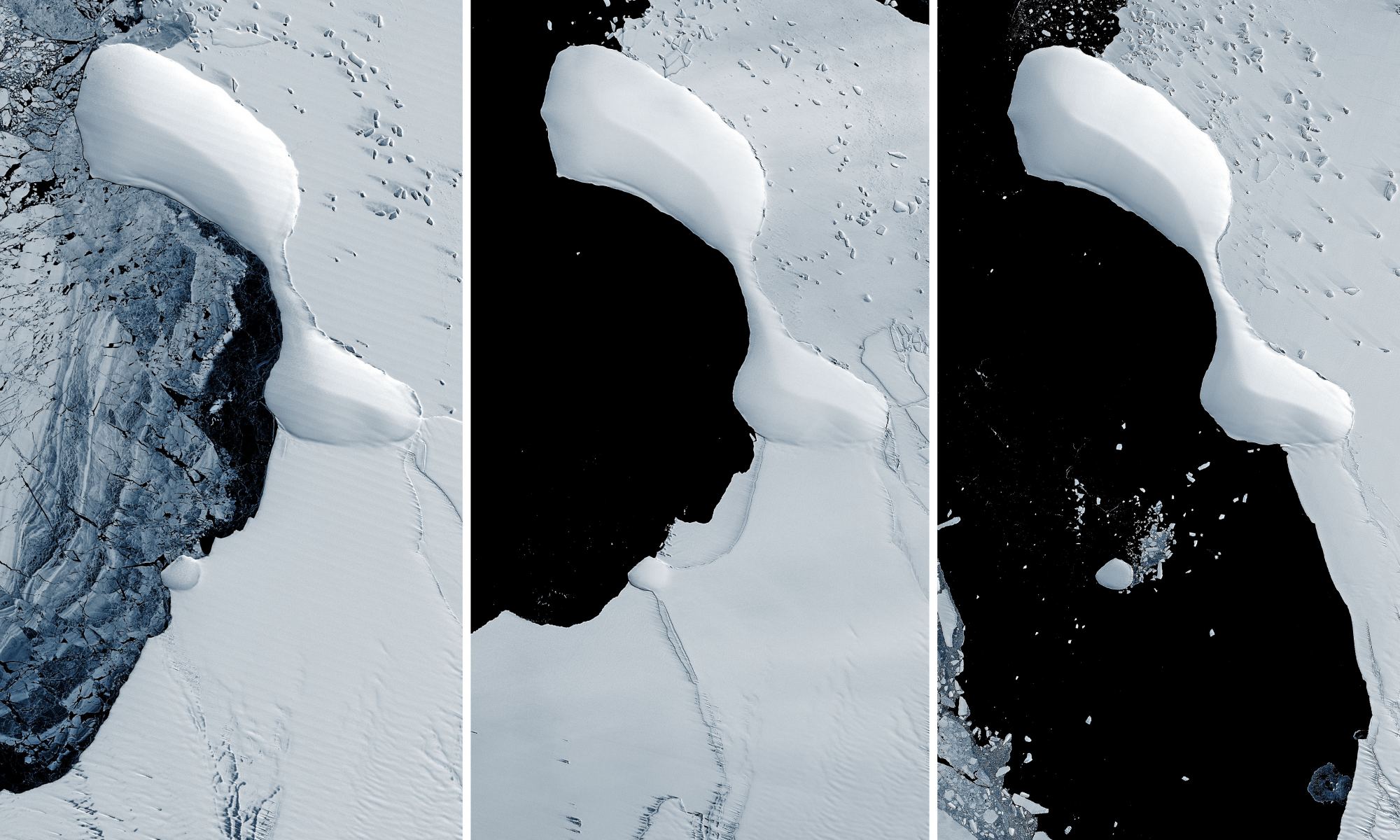
The eastern coast of Antarctica has lost most of the Glenzer and Conger ice shelves, as seen in these satellite images taken between November 15, 1989 - January 9, 2022. Credit: NASA GSFC/UMBC JCET.
Collapsing ice shelves on the eastern coast of Antarctica has revealed something never seen before: a landform that might be an island. But this is not the first newly revealed island off the Antarctic coast. A series of islands have appeared as the ice shelves along the continent’s coastline has disintegrated over the past few years.
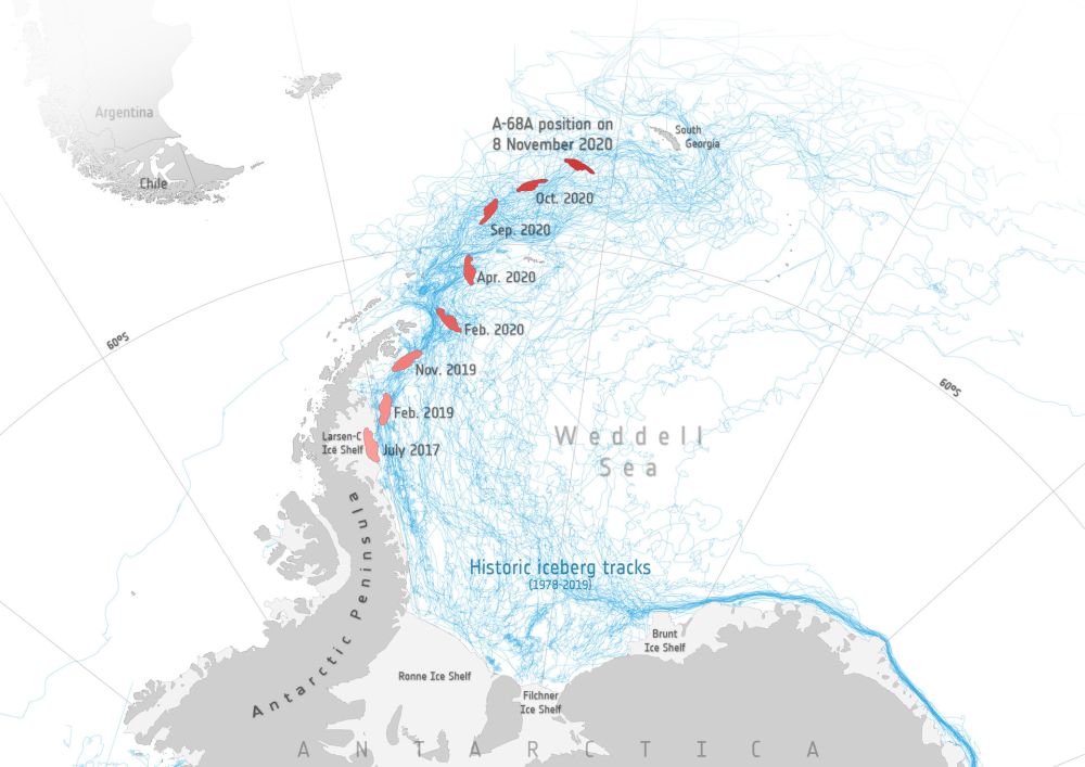
An iceberg the size of South Georgia Island is on a collision course with... South Georgia Island. Image Credit: contains modified Copernicus Sentinel data (2017–20), processed by ESA; Antarctic Iceberg Tracking Database
Back in July 2017, satellites watched as an enormous iceberg broke free from Antarctica’s Larsen C ice shelf on the Antarctic Peninsula. The trillion-ton behemoth has been drifting for over three years now. While it stayed close to its parent ice shelf for the first couple of years, it’s now heading directly for a collision with South Georgia Island.
It could be a slow-motion collision, but a collision nonetheless. If it does collide with the island and its shallow sea-floor, it won’t be the first iceberg to do so. And if the first one was any indication, wildlife could suffer.
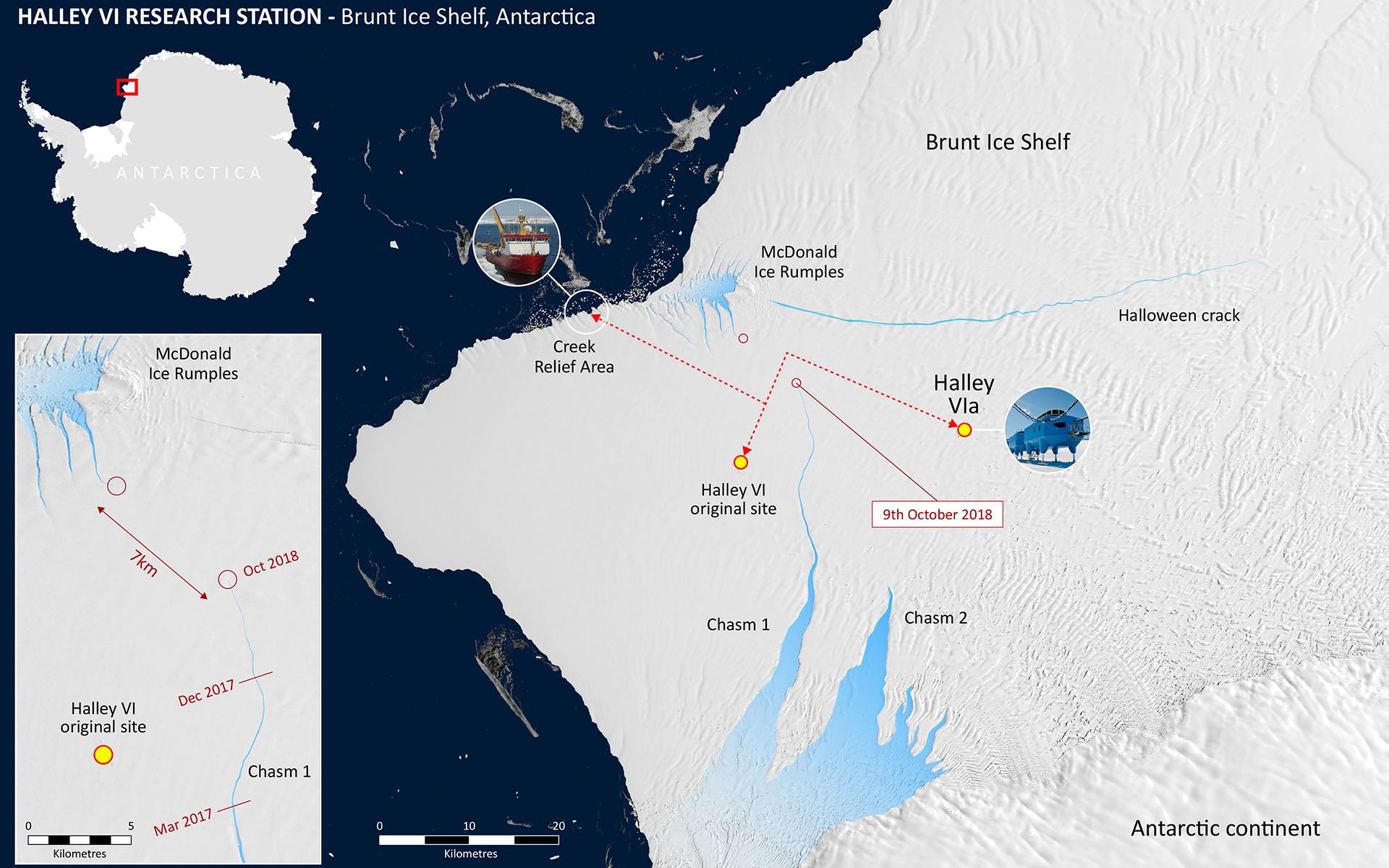
The Brunt Ice Shelf is about to calve an ice berg more than twice as large as New York City. Image: British Antarctic Survey.
An ice shelf in Antarctica is about to give birth to a baby. This baby is a giant, spawned by growing cracks in the Brunt Ice Shelf. It’s not clear what this’ll mean to the scientific infrastructure in the area, and to the human presence, which were both established in the 1950s.
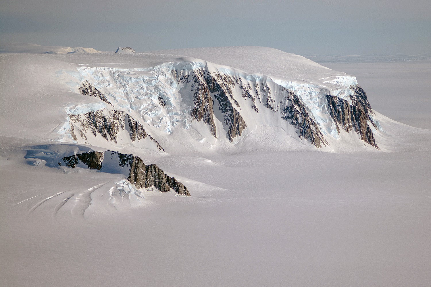
A view of mountains and glaciers in Antarctica’s Marie Byrd Land seen during the Nov. 2, 2014, IceBridge survey flight. Credit: NASA / Michael Studinger
One of the benefits of the Space Age is the way it has allowed human beings to see Earth in all of its complexity and splendor. In addition, it has allowed us to conduct studies of Earth’s surface and atmosphere from orbit, which helps us to see the impact we have on our the planet. It is with this purpose in mind that NASA’s Earth Observation Program has been monitoring the Arctic and Antarctic for many years.
For instance, Operation IceBridge has spent much of the past decade monitoring the Antarctic ice sheet for signs of cracks and flows. The purpose of this is to determine how and at what rate the ice sheet is changing due to Climate Change. Recently, NASA crews conducted a flight over the southern Antarctic Peninsula as part of Operation IceBridge ninth year, which resulted in some stunning pictures of the icy landscape.
The flight took place on November 4th, 2017, as part of IceBridge’s “Endurance West” mission to study sea ice. The path they chose follows the ground track of NASA’s Ice, Cloud, and land Elevation Satellite-2 (ICESat-2), an ice-mapping satellite that is scheduled for launch in late 2018. This path began at the northern tip of the Antarctic Peninsula and then moved southward across the Weddell Sea.
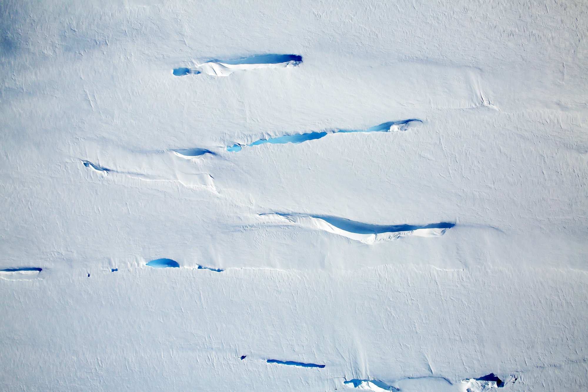
Semi-permanent cracks on the Antarctic Peninsula. Credit: NASA/Digital Mapping System.
The images the crew took aboard their P3 research plane were captured by a Digital Mapping System, a downward-pointing camera that collects thousands of high-resolution photographs during a single flight. While traveling over the southern Antarctic Peninsula, they imaged a landscape that resembled rapids, where the motion of rivers becomes amplified as the water flows through steeper, narrower terrain.
In a similar fashion, as ice flows through narrower canyons and down steeper bedrock, more fractures appear at the surface. But of course, the rate at which this takes place is much slower, which can make discerning movement in the ice sheet rather difficult. The first image (shown above) shows ice flowing into the southern part of the George VI ice shelf, which is located in Palmer Land south of the Seward Mountains.
In this location, cracks are likely to be a regular feature that form as the ice flows over the bedrock. However, since the ice flow is relatively slow (even on the steeper part of the bedrock), the surface cracks are not as dramatic as in other regions. For example, the second image (shown below), which shows a heavily crevassed glacier that measures about 21 km (13 mi) long and 11 km (7 mi) wide.
The glacier appears to be flowing west from the Dyer Plateau to George VI Sound while the north side merges with the Meiklejohn Glacier. The third image (bottom) shows a heavily crevassed glacier north of Creswick Peaks that also flows west into George VI Sound. In short, the pictures confirm that ice on the southern end of the Antarctic Peninsula is flowing towards the ocean.
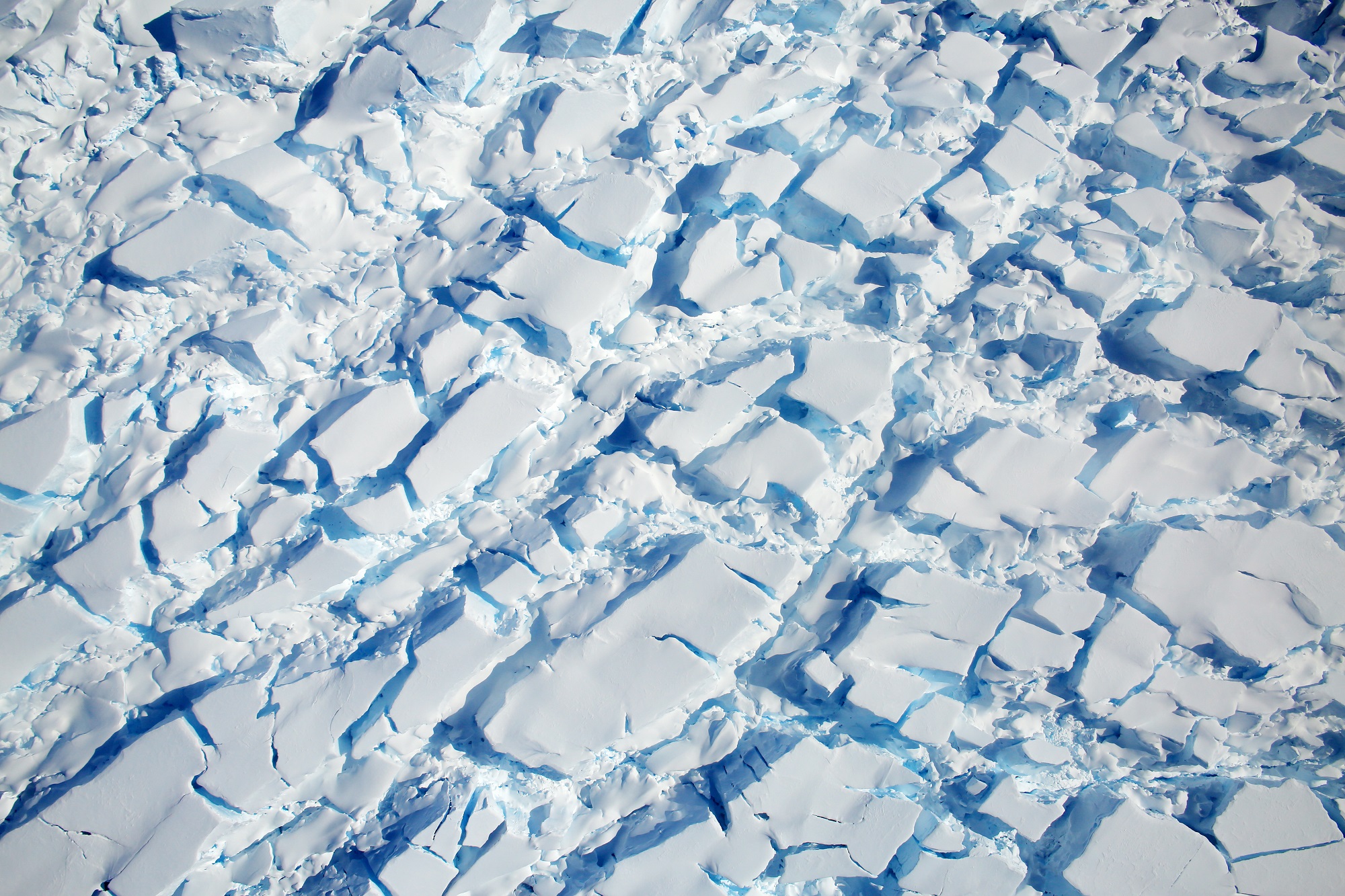
A heavily crevassed glacier flows west from the Dyer Plateau. Credit: NASA/Digital Mapping System
The purpose of IceBridge, which has been conducting regular measurements in the Antarctic Peninsula since 2009, has been to study just how fast and to what extent Climate Change has been impacting the region. While ice sheet loss is a well-documented phenomenon, scientists have known for some time that the most dramatic losses in Antarctica occur along its western side.
In addition, research has shown that the southern part of the peninsula is particularly vulnerable, as the glaciers and ice shelves there have become destabilized and are slowly feeding into the sea. And unlike sea ice, the land ice in this region has the potential to raise sea levels around the world. As Michael Studinger, the project manager for IceBridge, describes the operation:
“IceBridge exists because we need to understand how much ice the Greenland and Antarctic ice sheets will contribute to sea level rise over the next couple of decades. In order to do this, we need to measure how much the ice surface elevation is changing from year to year.”
Knowing how significant the impact of Climate Change will be is the first step in developing countermeasures. It also serves as a stark reminder that the problem exists, and that solutions need to be found before it is too late.
An airborne ‘eye in the sky’ has provided unprecedented views and details of a massive iceberg calving from its parent glacier in Antarctica. Essentially, we’re able to watch the process of an iceberg being born. NASA’s Operation IceBridge mission discovered a huge crack in the Pine Island Glacier in western Antarctica. The mammoth rift extends at least 18 miles and is 50 meters deep, and scientists say it could produce an iceberg more than 800 square kilometers in size.
“We are actually now witnessing how it happens and it’s very exciting for us,” said IceBridge project scientist Michael Studinger, Goddard Space Flight Center, Greenbelt, Md. “It’s part of a natural process but it’s pretty exciting to be here and actually observe it while it happens. To my knowledge, no one has flown a lidar instrument over an actively developing rift such as this.” Continue reading “An Iceberg Caught in the Act of Forming”