More Ancient Hot Springs Discovered on Mars?

Arabia Terra, a possible MSL landing site on Mars. Credit: NASA/JPL/HiRISE team

[/caption]

In March 2007, the Spirit rover found a patch of bright-colored soil rich in silica. Scientists proposed water must have been involved in creating the region, and not just water, but hot water. Now, data from retrieved from the Mars Reconnaissance Orbiter (MRO) suggest the discovery of another ancient hot springs region in Vernal Crater in Arabia Terra, an area in the northern hemisphere of Mars that is densely cratered and heavily eroded. The research team says the striking similarities between these features on Mars and hot springs found on Earth provide evidence of an ancient Martian hot-spring environment. On Earth these environments teem with microbial life.

If life forms have ever been present on Mars, hot spring deposits would be ideal locations to search for physical or chemical evidence of these organisms and could be target areas for future exploratory missions such as the Mars Science Labortory. Arabia Terra is currently on the list of possible landing sites for MSL.

In their research paper “A Case for Ancient Springs in Arabia Terra, Mars,” Carlton C. Allen and Dorothy Z. Oehler, from the Astromaterials Research and Exploration Science Directorate at the NASA Johnson Space Center, Houston, Texas, propose that new image data from the HiRISE (High Resolution Imaging Science Experiment) camera on MRO show structures in Vernal Crater that appear to be the product of ancient spring activity. The data suggest that the southern part of Vernal Crater has experienced episodes of water flow from underground to the surface and may be a site where Martian life could have developed.

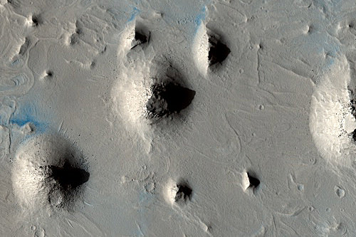
Vernal Crater is a 55-km diameter crater located at 6°N, 355.5°E, in the southwestern part of Arabia Terra. From orbital images, the crater appears to have layered sediments, and potentially, remnants of activity from water.

THEMIS image A. Credit: Allen and Oehler

One feature that is bright in both daytime and nighttime in THEMIS infrared images is prominent in the southern part of Vernal crater. In this image, marked A, the feature appears dark, as the THEMIS grayscale was inverted to resemble HiRISE images in the visible range. The feature is 3 km wide and is composed of alternating light-toned and dark-toned subunits, which the researchers interpret as cemented, resistant dunes,and water-laid deposits.

The research team compares this and other structures in the region with hot springs regions on Earth, using Google Earth. The similarities of the features on Mars and Earth, the researchers say, provides a strong case that the Vernal Crater structures are relics of ancient Martian springs.

Regional view of outcrops. CTX image P04_002456_1858.  Credit:  Allen and Oehlers
Regional view of aligned outcrops. CTX image P04_002456_1858. Credit: Allen and Oehlers

The team says their results are consistent with the growing body of orbital and rover data that is suggestive of widespread hydrothermal activity and possible spring deposits elsewhere on Mars.

“If clays or chemical precipitates such as evaporates or silica comprise the terraced structures or tonal anomalies, signatures of that life may be preserved in those minerals,” write the research team in their paper. “The fact that several other potential spring deposits occur on-trend with Vernal structures suggests that this may have been a significant province of long-lasting spring activity.”

Source: Paper: “A Case for Ancient Springs in Arabia Terra, Mars,” by Carlton C. Allen and Dorothy Z. Oehler.

How and Why Did Two Satellites Collide This Week?

A simulated view of the debris clouds shortly after the collision on Feb. 10, 2009. Image courtesy of Analytical Graphics, Inc. (www.agi.com)

[/caption]
The collision this week involving an active U.S. commercial Iridium satellite and an inactive Russian Cosmos 2251 satellite in low Earth orbit has, if nothing else, raised public awareness of the growing problem of space debris. But how and why did this collision happen? If NORAD, the U.S. Air Forces’s Space Surveillance Network, NASA’s Orbital Debris Program Office and other entities are tracking space debris, did anyone know the collision was going to occur? Those who analyze data and track satellites say predicting collisions is difficult because of changes in satellite orbits which occur due to solar radiation and the gravitational effects of the Moon and Earth. Therefore, the orbit analysis is only as good as the data, which may be imprecise. “The main problem here is the data quality for the data representing the satellites locations,” said Bob Hall, Technical Director of Analytical Graphics, Inc. (AGI), the company that released video and images on Thursday recreating the collision event. “Given the uncertainty in the accuracy of the TLE orbital data, I do not believe anyone was predicting or necessarily expecting an event.”

AGI has tools that run automatically every day such as SOCRATES – (Satellite Orbital Conjunction Reports Assessing Threatening Encounters in Space) which is based on the current space catalog supplied by NORAD to look for close approaches.

“This analysis is performed automatically every day and you can easily go in and search it,” Hall told Universe Today. “Because the analysis is performed with the public two-line element (TLE) set satellite catalog, the analysis is only as good as that imprecise data is. So when it shows conjunctions on any given day (and for Tuesday this Iridium event was not even in the ‘top 10’ close approach predictions!) this has to be taken with some uncertainty.”

Hall said the closest approach predicted for last Tuesday’s Iridium-Cosmos event was predicted to be 584 meters. “Again, as close as that sounds (and it is), there were at least 10 other on-orbit conjunction predictions that day alone with smaller miss distances,” Hall said.

Simulation of the satellite debris break-up. Image courtesy of Analytical Graphics, Inc. (www.agi.com)

The crash occurred on Tuesday 485 miles above northern Siberia in a crowded polar orbit used by satellites that monitor weather, relay communications and perform scientific surveys.

The International Space Station, as well as most satellites can be maneuvered out of harm’s way to avoid a possible collision, but a defunct satellite like the Russian Cosmos 2251 has no such ability.

Even with the uncertainties of tracking orbiting satellites, one group, the Secure World Foundation, is calling for the need to establish a civil space traffic control system.

“Unfortunately, it appears that there was data warning about the possibility of this collision beforehand,” noted Brian Weeden, Technical Consultant for Secure World Foundation. “However, it must be stressed that close approaches between satellites somewhere in Earth orbit occurs on almost a weekly basis…and until this event, have never before resulted in an actual collision.”

Weeden agreed that in every case it is impossible to give a definite answer on whether or not two objects will actually collide, only probabilities and potential risks.

“Getting the right information to the right authorities in time to make the right avoidance maneuver decision is a very complicated process that doesn’t entirely exist yet,” Weeden said. “The Secure World Foundation is working with many other organizations around the world to try and develop this process.”

The Secure World Foundation endorses the creation of a space traffic control system.

“This collision underscores in a dramatic way the importance of instituting an international civil space situational awareness (SSA) system as soon as possible,” said Dr. Ray Williamson Executive Director of Secure World Foundation.

Williamson said that such a civil SSA system could have been used to warn the Iridium operations managers of the danger of collision and allow them to take evasive action. “In the absence of reliable ways to clear debris from orbit, it will be increasingly important to follow all active satellites to prevent future preventable collisions,” he added.

Before this collision, another collision event happened in 1996, when a French spy satellite called Cerise was severely damaged by a piece of debris from the rocket that launched it.

The United States tracks debris or micro-meteorites down to 10 cm wide, but objects as small as a scrap of peeled-off paint can pose a threat once they start hurtling at orbital speeds through space.

Sources: Email exchange with Bob Hall of AGI, Secure World Foundation press release, Reuters

Q&A with Kepler Scientist from — Iowa?

Artist's rendering of the Kepler Mission (NASA)

[/caption]

kawaler

With a target launch date of March 5, NASA’s Kepler mission is just weeks away from its tantalizing journey to peer at faraway stars and the Earth-like planets they may be hosting. Hundreds of astronomers from all over the world have a stake in the data. The United States participants hail from all the usual astronomy hubs, among them Arizona, California, Texas and … Iowa? Steve Kawaler, an astrophysicist at Iowa State University, took a moment to chat with Universe Today about his role in a less-publicized goal of the Kepler mission — and his research out of a less-publicized astronomy program.

Q. Why Iowa?

Kawaler: Iowa’s a great place. I’m originally a New Yorker, and went to grad school at the University of Texas, but landing at Iowa State (mostly by chance) still feels right. 

(Still Kawaler:) You can get a lot of work done here. We’ve organized and run the Whole Earth Telescope from here for about 10 years. A few years ago [in 2004], the WET team showed a pulsating white dwarf (BPM 37093, but later dubbed the ‘Diamond Star’) may truly be crystalline. Finding one of the biggest diamonds in the cosmos and announcing it around Valentine’s Day was pretty fun! I’ve been part of some big collaborations where nearly all the work is done remotely, and that is important as we stare at the mountain of data we’re about to see.

Q. What’s your role in the Kepler mission?

Kawaler: I serve on the Steering Committee for the Kepler Asteroseismology Research Consortium. We’ll use the exquisite time-series measurements of the brightness of over 100,000 stars to measure their internal properties.  The KASC has over 250 scientists involved, and the Steering Committee is charged with helping organize and coordinate their efforts in reducing and interpreting the data.

Q. What’s most exciting about the science in this mission?

Kawaler: The most exciting discovery will be the discovery of Earth-like planets around other stars. It’s what we all wonder about – are there other planets out there that host life?  That said, most of the stars that Kepler examines won’t show any signs of planetary transits … but the data will provide a gold mine of information about how stars behave. From the point of view of my own research, the most exciting thing that will come out will be improvement, by a factor of almost 100, in the measure of brightness of over 100,000 stars. Asteroseismologists are drooling at this prospect, because we expect to find oscillations in many stars, but this huge increase in sensitivity is bound to reveal new phenomena that we can’t even guess at yet. 

Q. A press release described part of your interest as “peering into stars.” Can you elaborate?

Kawaler: Until very recently, everything we know about stars, we learned from looking at the outsides. When you want to really need to know what’s going on, you need some sort of probe that goes beneath the surface.  For the Earth, seismic waves generated by earthquakes give you that kind of probe.  For stars, we have to measure their vibrations from (very!) far away.  Those vibrations produce only tiny signals — very subtle brightness variations. We can also look at how the surfaces move up and down and use those as a measure of the oscillations that are going on inside. Once we do make those measurements, we use the tools that terrestrial seismologists have developed, along with some of our own that are adapted to the special circumstances within stars, to probe the insides of the stars.

Q. Why can’t we do this work from Earth?

Kawaler: The short answer is that we can, sort of, but Earth is a really poor place to do this kind of work.  An astronomer can only look at a star for a couple hours a night before the star sets or the sun comes up. It’s kind of the equivalent of listening to Beethoven’s 5th Symphony and listening to every third note. You can sort of do it from the ground by putting together a network of telescopes.  We’ve had some remarkable successes.  But it’s much easier if you can observe from a platform that isn’t rotating. And if that platform is above the atmosphere, you get the added benefit of a direct line of sight to the star that doesn’t have the atmosphere degrading the image.  With continuous views and no atmosphere, Kepler can do way, way better than we can from the ground.

6. Is this helping to realize a life-long ambition for you?

Kawaler: Absolutely – I’ve always been a space program ‘geek.’ I grew up in the 60s. My older brother grew up in the 50s, and he got caught up in the whole Sputnik thing. There were all these books and toys about space; I picked them up and was instantly fascinated. Later, I was just riveted to the TV all the time, watching Gemini and the Apollo missions. I guess I still haven’t grown out of it. My brother is one of the few rabbis that dresses as Captain Kirk on Purim, Jewish Halloween, so I guess he didn’t grow out of it, either. I’m actually heading down to Florida for the launch, with my father, so he can finally be convinced I didn’t have to be a ‘real doctor’ — I can be a PhD.

Sources: Steve Kawaler, NASA

kepler-1
Kepler's search space in the Milky Way, courtesy of NASA.

Orbital Spares: Iridium Already Replaced Destroyed Satellite

An Iridium satellite in orbit (Iridium)

[/caption]

On Tuesday, a communications satellite in the Iridium fleet suffered complete obliteration at the hands of a defunct Russian satellite Cosmos 2251. Although satellites have been hit by space junk in the past (four times since 1996), this is the first time a satellite has suffered a direct hit… from another satellite. The aftermath of the collision was messy and US Space Command is tracking hundreds of pieces of debris. There is some concern the ex-satellite parts could collide with other active satellites or even the International Space Station (although the odds are still well within safety margins for the crew), but much effort is being put into tracking and modelling the new space junk additions.

If you thought AGI was quick at assembling those superb satellite animations only a day after the event, you’ll be even more impressed with the company who lost their expensive piece of kit. Iridium has a replacement satellite. A spare. Already in orbit. And plans are afoot to “plug the hole” in the satellite phone network. Now that’s what I call service!

The Iridium constellation - a robust satellite network (Iridium)
The Iridium constellation - a robust satellite network (AGI)
It’s probably to be expected, especially when considering competition in the communication industry, but it is an amazing feat to have a backup plan enacted only a couple of days after losing an expensive satellite. But this isn’t only a plan, it’s a satellite, already in orbit, waiting to be powered up and redirected to its predecessor’s old orbit (or at least fulfil it’s coverage on the ground).

Although Iridium was concerned about patchy service for some customers, the satellite network’s mesh design will lower the likelihood of any service outages. So put your satellite phone away, the signal should still be strong.

The Iridium service hole patch addresses a significant portion of outages that customers otherwise might have experienced,” said Iridium spokesperson Liz DeCastro. “Due to the mesh design of the Iridium network, the company expects further impact to customers to be limited.”

So it sounds as if it’s a sturdy network that can easily deal with one lost component, but the best was yet to come in the press release. “The company also is taking the necessary steps to replace the lost satellite with one of its in-orbit spares, and the operational planning stage is underway,” DeCastro added.

Naturally, Iridium is investigating the incident, saying that they are working “with the appropriate government agencies”. At this time it is unclear whether Iridium will be seeking compensation from the Russian government, but this is a possibility. After all, dead satellites should either be de-orbited or moved from the paths of operational satellites. Unfortunately for Iridium 33, Cosmos 2251 was left at an altitude used by commercial satellite companies.

There may be no LEO traffic control, and there is certainly no “right of way” in space, the responsibility to dispose of space junk lies with the satellite’s last owner. In this case, that would be Russia.

Sources: Tech Radar, Iridium Press Release

Why Do Some Scientists Consider Pluto to Not Be a Planet?

Question: Why do some scientists consider Pluto to Not Be a Planet?

Answer: Since its discovery in 1930 until 2006, Pluto was considered a planet, just like the others in the Solar System. But in 2005, Caltech researcher Mike Brown announced that he had discovered a new object which was more distant, but larger in the Solar System.

This object was originally named 2003 UB 313, but then was given the official designation of Eris, after the Greek God of strife and discord. It briefly had the nickname Xena – yes, after the TV show.

With the discovery of Eris, astronomers had to reconsider their definition of a planet. Since Eris is larger than Pluto, the number of planets in the Solar System would need to be expanded to 10. And who knows how much larger it would become with future discoveries.

The International Astronomical Union met in Prague in 2006 to make a final decision. They decided that a planet must fulfill three criteria:

  • It must orbit the Sun
  • It must have enough mass to pull itself into a spherical shape
  • It must have cleared out the other objects in its orbit.

It’s this 3rd part where Pluto falls down. Pluto has only a fraction of the mass of the rest of the objects in its orbit, while the rest of the planets have essentially cleared theirs out completely. Does Pluto have moons? It does, but even with the mass of its moons, Pluto still doesn’t dominate its orbit.

Pluto, Eris and the Asteroid Ceres were given the new designation of “dwarf planet”.

I go into this in much more detail with the article, Why is Pluto Not a Planet?

Why Does Jupiter Have the Great Red Spot?

Frequently, readers send us questions here on Universe Today. One very good question is ”why does Jupiter have the Great Red Spot?” The short answer is that the Great Red Spot is a storm that has been raging since the 1600s, but a short answer does not tell the whole story. Read on for a much more detailed accounting.

The Great Red Spot (GRS) is an anti-cyclonic(rotates counter-clockwise) storm that is located 22° south of Jupiter’s equator. The storm has lasted an estimated 346 years, but many scientists believe that it is much older. The storm is known to have been larger than 40,000 km in diameter at one time and can be easily seen with large backyard telescopes. Currently it measures approximately 24–40,000 km east–to–west and 12–14,000 km north–to–south. The GRS is large enough to envelope two to three Earths. Despite the GRS’s enormous size, it is shrinking. In 2004, it had about half the longitudinal size that it had a century ago. Some scientist estimate that if it continues to shrink at its current rate, it could become circular by 2040. A study by scientists at the University of California, Berkeley showed that the GRS lost 15 percent of its diameter along its major axis between 1996 and 2006. Xylar Asay-Davis, a team member on the study, noted that the spot is not disappearing because ”[v]elocity is a more robust measurement because the clouds associated with the Red Spot are also strongly influenced by numerous other phenomena in the surrounding atmosphere.”

Infrared data indicates that the GRS is colder and located at a higher altitude than most of Jupiter’s other clouds. The cloudtops of the GRS are about 8 km above the surrounding clouds. The storm is held in place by an eastward jetstream to its south and a very strong westward jetstream to its north. Winds around the edge of the GRS peak at 432 km/h, but winds within the storm seem to nearly none existent, with little inflow or outflow. In 2010, astronomers imaged the GRS in the far infrared and found that its central(reddest) region is warmer than its surroundings by about 4 K. The warm airmass is located in the upper troposphere. This warm central spot slowly rotates in the opposite direction of the remainder of the storm and could be a remnant of air flow in the center.

Alright, so why is the storm red? The exact cause of the coloring has not been proven, but…lab experiments support the theory that the color is caused by complex organic molecules, red phosphorus, or another sulfur compound that are pulled from deeper within Jupiter. The color of the GRS varies. At times it is brick-red, fading to a pale salmon, and even white. The spot occasionally disappears from the visible spectrum and can only be seen as the Red Spot Hollow; its niche in the South Equatorial Belt(SEB). The visibility of GRS is apparently coupled to the appearance of the SEB. If the SEB is bright white, the spot tends to be dark. When it is dark, the GRS is usually light. The periods that the color changes last and occur on an unpredictable schedule.

As you can see, the answer to ”why does Jupiter have the Great Red Spot?” has been well researched by NASA and other space agencies. While the answer is not crystal clear at this time, future missions to the planet are designed to better study the atmosphere; hopefully, rendering the answers scientists seek.

We have written many articles about Jupiter for Universe Today. Here are some interesting facts about Jupiter, and here’s an article about the color of Jupiter.

If you’d like more information on Jupiter, check out Hubblesite’s News Releases about Jupiter, and here’s a link to NASA’s Solar System Exploration Guide to Jupiter.

We’ve also recorded an episode of Astronomy Cast just about Jupiter. Listen here, Episode 56: Jupiter.

Sources:
http://www.nasa.gov/multimedia/imagegallery/image_feature_413.html
http://www.nasa.gov/centers/goddard/news/topstory/2006/little_red_spot.html

Why Can’t We Launch Garbage into Space?

Now wouldn’t that be a tidy solution to a big problem? Gather together all the garbage, bundle it up and fire it off into space. Maybe just dump it into the Sun. We could live in a world without trash.

There are just two problems: humans produce an enormous amount of garbage; and rocket launches are extremely expensive.

It’s been estimated that launching material on the space shuttle costs about $10,000/pound ($22,000/kg). Even if engineers could bring down prices by a factor of 10, it would still be thousands of dollars to launch the garbage into space. Let’s imagine a wonderful dream world, where launch costs could be brought down to $1,000/kg – a factor of 1/20th the cost to launch on the space shuttle.

It has also been estimated that the United States alone produces 208 million metric tonnes of garbage per day… per day! So, to launch all that trash into space would cost the United States $208 trillion per day… per day!

The gross domestic product of the United States was $13.13 trillion in 2006, which works out to be about $36 billion a day. In other words, the United States would need to spend 5,800 times its daily gross domestic budget, just to launch its trash into space.

What about nuclear waste? A nuclear reactor releases about 25-30 tonnes of spent fuel every year. With our dream budget of $1,000/kg, that would cost about $25 million to launch a single reactor’s waste into orbit. According to Wikipedia, there are 63 operating reactors in the US, so it would cost about $1.6 billion/year to dispose of the nuclear waste generated.

It’s been estimated that Yucca Mountain – the United State’s current plan to store nuclear waste – will cost about $58 billion to store waste over the course of 100 years. So storing waste in Yucca Mountain will cost about 1/3rd the price of launching that material into space. Not to mention the terrible risk of launching rockets full of nuclear waste into space – imagine what might happen if a rocket exploded in mid-flight…

I’m sure I’ve made some math errors here somewhere…

We have written many articles about space for Universe Today. Here’s an article about the problem with space debris, and here’s an article about human space exploration.

Want more resources on space? Here’s a link to NASA’s Human Spaceflight page, and here’s NASA’s Space Place.

We have also recorded many episode of Astronomy Cast about space. Episode 100 is all about rockets, and Episode 84 is about getting around the Solar System.

Who Was the First Animal to go into Space?

The first rocket ever sent to space probably carried bacteria or some other accidental passenger. But the first animals ever intentionally sent into space were fruit flies launched aboard a V2 rocket in 1947. US scientists were studying the effects of radiation at high altitude.

A rhesus monkey called Albert 1 became the first monkey launched into space on June 11, 1948; also on board a US-launched V2 rocket.

These were just suborbital flights, though. The first animal to actually go into orbit was the dog Laika, launched on board the Soviet Sputnik 2 spacecraft on November 3, 1957. Unfortunately, Laika died during the flight.

At least 10 more dogs were launched into space and on sub-orbital flights by the Soviets until April 12, 1961, when Yuri Gagarin became the first human in space.

Since those first historic launches, many monkeys, chimpanzees, rats, mice, frogs, spiders, cats and even a tortoise were launched into space.

Read more about Laika’s mission in this article.

Want more resources on space? Here’s a link to NASA’s Human Spaceflight page, and here’s NASA’s Space Place.

We have also recorded many episode of Astronomy Cast about space. Episode 100 is all about rockets, and Episode 84 is about getting around the Solar System.

Climate Change Satellite gets Green Light for Launch

The European Space Agency’s Soil Moisture and Ocean Salinity (SMOS) satellite has been cleared for takeoff, following nearly a year in limbo while the mission team awaited the go-ahead from a private launch company.

Originally expected to launch in 2008, SMOS has been in storage at Thales Alenia Space’s facilities in Cannes, France since last May, awaiting a  launch appointment at the Russian Plesetsk Cosmodrome, north of Moscow. If all goes according to plan, the craft will now launch between July and October, the second ESA mission in a series of six designed to observe Earth from space and bolster an understanding of climate change. The first of the satellites in its new Living Planet Program, The Gravity field and steady-state Ocean Circulation Explorer (GOCE), is scheduled to go up March 16. 


Over its lifetime of about 20 months, GOCE will map global variations in the gravity field – crucial for deriving accurate measurements of ocean circulation and sea-level change, both of which are affected by climate change.

SMOS, circulating at a low orbit of around 750 km (466 miles) above the Earth,  will be the first mission dedicated to mapping soil moisture and ocean salinity. Salinity in the oceans has a significant impact on ocean circulation, which in turn helps drive the global climate. Among other applications, understanding the salinity and temperature of the seas will lead to easier predictions of the zones where hurricanes intensify. A specialized radiometer has been developed for the mission that is capable of observing both soil moisture and ocean salinity by capturing images of emitted microwave radiation around the frequency of 1.4 GHz (L-band). SMOS will carry the first-ever, polar-orbiting, space-borne, 2-D interferometric radiometer. The mission is designed to last three years.

Here’s a rundown of the final four planned crafts in the series:

  • ADM-Aeolus (Atmospheric Dynamics Mission), with a 2010 launch date, will collect data about the global wind profile to improve weather forecasting.
  • CryoSat-2, set to launch in late 2009, will determine variations in the thickness of the Earth’s continental ice sheets and marine ice cover to further our understanding of the relationship between ice and global warming. CryoSat-2 replaces CryoSat, which was lost at launch in 2005.
  • Swarm, due for launch in 2010, is a constellation of three satellites to study the dynamics of the magnetic field to gain new insights into the Earth system by studying Earth’s interior and its environment.  
  • EarthCARE (Earth Clouds Aerosols and Radiation Explorer), lanching in 2013, is a joint European-Japanese mission that aims to improve the representation and understanding of the Earth’s radiative balance in climate and numerical weather forecast models.
Source: ESA