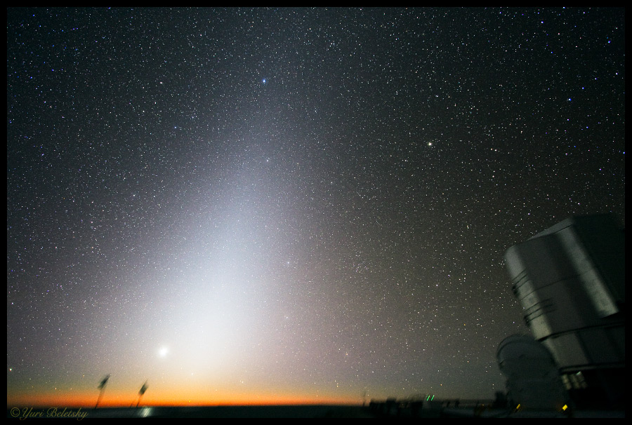
Zodiacal light can be seen in the sky before sunrise or after sunset. Credit: Yuri Beletsky/ESO Paranal
[/caption]
Imagine you could see the position of the Sun, in the sky, relative to the stars (and galaxies, and quasars, and …). If you could, and if you plotted that position throughout the year you’d get a line; that line is called the ecliptic.
And why is it called the ecliptic? Because when the new or full Moon is very close to this, there will be an eclipse (of the Sun, and Moon, respectively).
The Earth goes round the Sun, in an orbit. That orbit defines a plane, which is an infinite two-dimensional sheet; the plane of the ecliptic.
The other planets in the solar system orbit the Sun in planes too, but those planes are slightly tilted with respect to the plane of the ecliptic … so transits of Venus (across the Sun) are quite rare (most times Venus passes either above or below the Sun, when it’s between Earth and the Sun). Mutual transits and occultations of planets are even rarer.
If you’re in a location relatively free of light pollution, on a clear, moonless night you may see zodiacal light. If you trace a line through the middle of it, you’re tracing the ecliptic (zodiacal light is due to reflection of sunlight off dust; dust in the solar system is concentrated in a plane close to the ecliptic plane).
Today astronomers use equatorial coordinates to give positions on the sky, right ascension (RA) and declination (Dec); these are like projections of longitude and latitude out into space (or onto the celestial sphere). However, in Europe ecliptic coordinates were used (up to the 17th century anyway). Here’s a curious fact: historically, Chinese astronomers used equatorial coordinates!
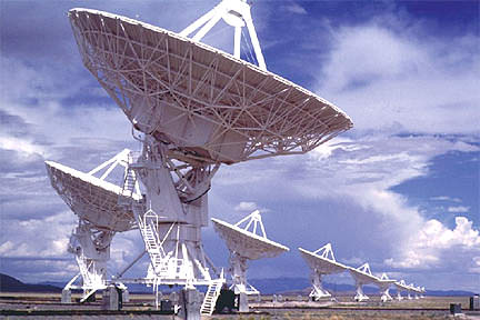
Radio Telescopes. Credit: University of Washington
Altazimuth is a contraction of altitude-azimuth; in astronomy it most often refers to a type of telescope mount (and is sometimes called alt-az), but it can also mean a coordinate system.
Altitude means the angular distance above the horizon; straight up (overhead) is 90o (and is called the zenith). Azimuth is also an angular distance, measured clockwise from north (so east is 90o). Any point, or direction, in the sky has one – and only one – altitude and azimuth; in other words, the altitude and azimuth are the coordinates of the point (on the celestial sphere).
An altazimuth telescope mount is one that can move separately in altitude (up and down, vertically) and azimuth (side to side, horizontally). Small telescopes used by amateur astronomers tend to have altazimuth mounts; larger ones tend to have equatorial mounts … unless they are Dobsonian. Why? Because while alt-az mounts are generally cheaper, tracking astronomical objects (like stars) is much easier with equatorial mounts.
Historically, the telescopes used by professional astronomers did not have alt-az mounts, because automatic tracking was impossible. As computers became powerful and cheap enough, they could be used to control the motors on each axis of an altazimuth mount; today, almost all ground-based astronomical telescopes have altazimuth mounts, whether optical, radio, or even high energy gamma ray! The first really large optical telescope to use an altazimuth mount is the 6-meter Bol’shoi Teleskop Azimultal’nyi, in Russia.
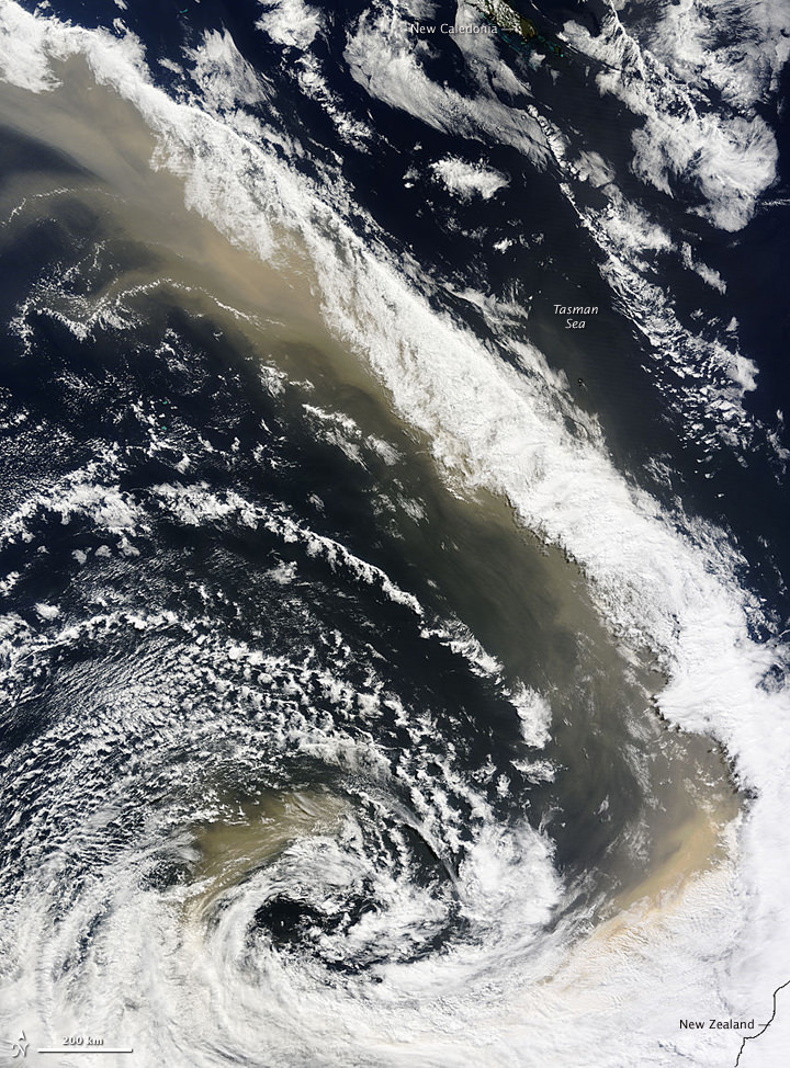
A river of dust over Eastern Australia on Sept. 24, 2009. NASA image courtesy Jeff Schmaltz, MODIS Rapid Response Team at NASA GSFC. Caption by Holli Riebeek.
[/caption]This isn’t a special effect image from a new catastrophe movie; it is an actual satellite image of the dust storm sweeping over and around eastern Australia, heading across the Tasman Sea toward New Zealand. A dense wall of dust descended upon Sydney on Sept. 23, creating an apocalyptic scene (see these images from Boston Globe’s Big Picture) and the river of dust continues unabated across water. The Moderate Resolution Imaging Spectroradiometer (MODIS) on NASA’s Terra satellite captured this image of the storm on September 24, at 11:10 a.m., New Zealand time (23:10 UTC on September 23). The distance between the far northern edge of the plume and the southern edge is about 3,450 kilometers (2,700 miles), roughly equivalent to the distance between New York City and Los Angeles. Below, see how the storm progressed across the Sea later in the day.
Dust storm over Australia during the afternoon of Sept. 24, 2009. NASA image courtesy Jeff Schmaltz, MODIS Rapid Response Team at NASA GSFC.
By the early afternoon of September 24, 2009, when the same satellite acquired this image, the thick dust that had covered the eastern shore of Australia previouly, stretched in a long plume from northern Queensland to New Zealand. This image shows the northern portion of the plume off the coast of Queenland. The tan dust is densely concentrated in a compact plume that mirrors the coastline. The gem-like blue-green Great Barrier Reef is visible beneath the plume near the top of the image where the tan dust mingles with gray-brown smoke from wildfires.
NASA has the absolute best resources on the web for pictures of space. We write so many articles about space here on Universe Today, so we’ve learned all the best places to look to get the latest and greatest NASA pictures.
Before we go right to some sites, here’s a general tip that you can use when you’re looking for NASA pictures. Use Google, but have it search for images within NASA’s sites. For example, let’s say that you’re looking for an astronomy picture of Mars, but you want it to be a NASA image. Search in Google for: mars picture site:nasa.gov. You can also switch over to the images tab and see lots and lots of images from NASA. You should be able to find the one you’re looking for.
Perhaps the best place to start is NASA’s Featured Images and Galleries. This is linked from the main NASA page and features current pictures as well as classics from the past. It also links you to other NASA image gallery sites.
Another classic is the Astronomy Picture of the Day. Keep in mind that although it’s endorsed by NASA, the pictures featured in Astronomy Picture of the Day are owned and copyright by the original photographers. So you can’t just use their pictures without asking permission first.
There’s a fairly new service out called NASA Images. It’s got a huge catalog of NASA pictures, with cool tools that let you organize and download your favorites.
The NASA Image Exchange is a huge database of NASA pictures. You can search by object, or by spacecraft and use other constraints to find the exact image you’re looking for.
The Johnson Digital Image Collection has photographs from all of NASA’s human spaceflight, from the original Mercury and Gemini flights, though the Apollo landings, right up until the space shuttle missions.
We have also recorded many episodes of Astronomy Cast about space, and we talk about NASA pictures all the time. Listen to this, Episode 88: The Hubble Space Telescope.
When it comes to the Moon, there are times when I feel like the “Queen of Selene”. In just a few short weeks there will be a whole new style of lunar observing book out on the market, and just when I thought I’d heard it all and seen it all… along comes something new! While the header photograph on this article is absolutely spectacular, you’re going to go about your day (and night) smiling if you stop to take a look at what’s inside…
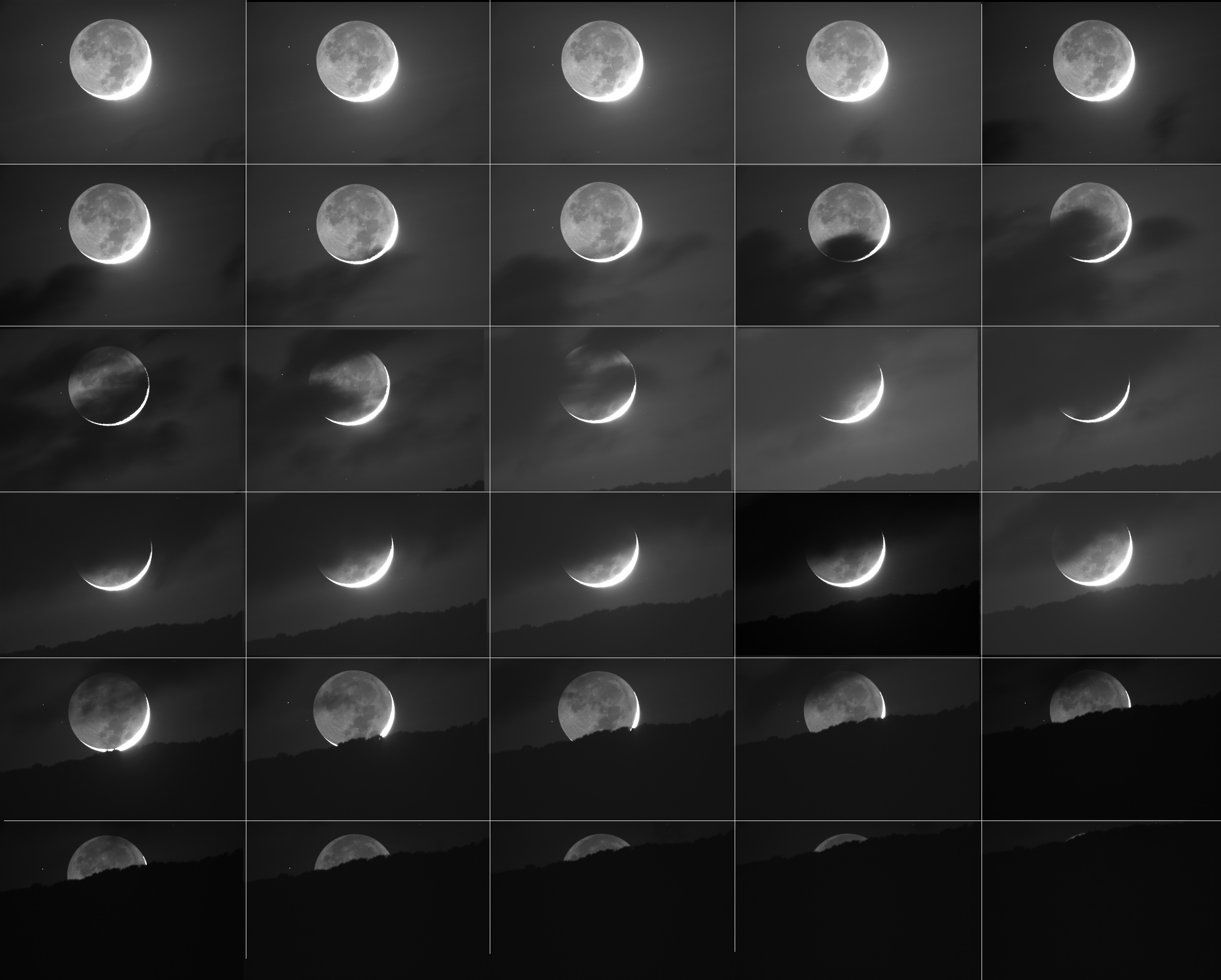
After spending an entire weekend with close friend, professional astronomer and member of the USGS team – Brent Archinal – who has been mapping out the information from the LRO, I’ve been in a real “Moon” mindset. Even our UT articles have seemed to have been geared towards our nearest astronomical neighbor, too! So, it just stands to reason that others might be feeling the call of lunacy as well. As it just so happens, one of the most prolific, dedicated and innovative astrophotographers I know – Joe Brimacombe – wasn’t cursing the Moon for re-appearing this month… He was celebrating it. Using a variety of techniques, he’s captured one of the most unique sets of sequences I’ve ever seen and I just had to share it with you!
“On the 20th September 2009 a crescent Moon set over the mountains behind Cairns and was captured in all its glory from Coral Towers Observatory using a variety of infrared cameras.” said Dr. Brimacombe, “These recordings not only show a majestic Moonset, but also the dramatic retrograde motion of the Moon against the fixed background of stars over a mere six minute period.”
This is simply one of those videos that were too good to go left unnoticed. Not only did it appeal to my scientific side, but it totally restored my faith that others can not only be creative and innovative – but know how to have fun, too!
I hope you enjoyed…
“Infrared Moonset” photo and video are courtesy, credit and copyright of Joe Brimacombe – Southerngalactic Imagers.
Greetings, fellow SkyWatchers! We’re back and recovered from a star party – and what an awesome time! (I felt like Dorothy in the “Land of Oz”… Comets and meteors and galaxies… oh, my!) I am sure that many of you also enjoyed a great time and although the Moon is back on this weekend scene, why not celebrate it? Just how long has it been since you’ve kicked back and relaxed with a little lunacy in your scope? Pick up a sketchbook, or get creative with a camera! Lunatic fringe? I know you’re out there. And I’ll see you inside…
Friday, September 25, 2009 – Today we celebrate the 1625 birth on this date of Ole (Christensen) Romer. Romer, by timing Jupiter’s moons being eclipsed, was the first to prove that light had a finite speed. Let’s walk upon our own Moon this evening as we take a look at sunrise over one of the most often studied and mysterious of all craters, Plato. Located on the northern edge of Mare Imbrium, and spanning 95 kilometers in diameter, Class IV Plato is simply a feature that all lunar observers check because of the many reports of unusual happenings. Over the years mists, flashes of light, areas of brightness and darkness, and the appearance of small craters have become a part of Plato’s lore.
On October 9, 1945, an observer sketched and reported ‘‘a minute but brilliant flash of light’’ inside the western rim. Lunar Orbiter 4 photos later showed where a new impact may have occurred. Although Plato’s interior craterlets average between less than 1 and up to slightly more than 2 kilometers in diameter, many times they can be observed, and sometimes they cannot be seen at all under almost identical lighting conditions. No matter how many times you observe this crater, it is ever-changing and very worthy of your attention!
Saturday, September 26, 2009 – Tonight’s featured lunar crater will be located on the south shore of Mare Imbrium right where the Apennine mountain range meets the terminator. Eratosthenes is unmistakable at 58 kilometers in diameter and 375 meters deep.
Named after the ancient mathematician, geographer, and astronomer Eratosthenes, this splendid Class I crater will display a bright west wall and a deep interior, which contains its massive crater-capped central mountain reaching up to 3,570 meters high! Extending like a tail, an 80-kilometer-long mountain ridge angles away to the southwest. As beautiful as Eratosthenes appears tonight, it will fade away to total obscurity as the Moon becomes more nearly full. See if you can spot it in 5 days!
Now let’s journey to a very pretty star field as we head toward the western wingtip of Cygnus, to have a look at Theta, also known as 13 Cygni (RA 19 36 26 Dec +50 13 15). Theta is a beautiful main sequence star that is also considered by modern catalogs to be a double. For large telescopes, look for a faint (13th magnitude) companion to the west. But it’s also a wonderful optical triple! In the field with Theta to the southeast is the Mira-type variable R Cygni, which ranges in magnitude from around 7–14 in slightly less than 430 days. This pulsating red star has a really interesting history that can be found at American Association of Variable Star Observers (AAVSO) and is circumpolar for far northern observers. Check it out!
Sunday, September 27, 2009 – Today we celebrate the 1814 birth on this date of Daniel Kirkwood. In 1866, this American astronomer was the first to publish his discovery of gaps in the distances of asteroids from the Sun, the ‘‘Kirkwood Gaps.’’ Not only did he study the orbits of asteroids, but he was also the first to suggest that meteor showers were caused by orbiting debris from comets. Known as ‘‘the American Kepler,’’ Kirkwood went on to author 129 publications, including three books.
Tonight on the Moon, let’s take an in-depth look at one of the most impressive of the southern lunar features—Clavius. Although you cannot help being drawn visually to this crater, let’s start at the southern limb near the terminator and work our way up.
Your first sighting will be the large and shallow dual rings of Casatus, with its central crater, and Klaproth adjoining it. Further north is Blancanus, with its series of very small interior craters, but wait until you see Clavius. Caught on the southeast wall is Rutherford, with its central peak, and crater Porter on the northeast wall. Look between them for the deep depression labeled D. West of D you will also see three outstanding impacts: C, N, and J; CB resides between D and Porter. The southern and southwest walls are also home to many impacts, and look carefully at the floor for many, many more! Clavius has been often used as a test of a telescope’s resolving power to see just how many more craters you can find inside it. Power up and enjoy!
This week’s awesome photos are (in order of appearance): Plato area (credit—Sketch by Deirdre Kelleghan), Eratosthenes (credit—Alan Chu), Theta Cygni (credit—Palomar Observatory, courtesy of Caltech), Daniel Kirkwood (widely used public image) and Clavius (credit—Wes Higgins). We thank you so much!
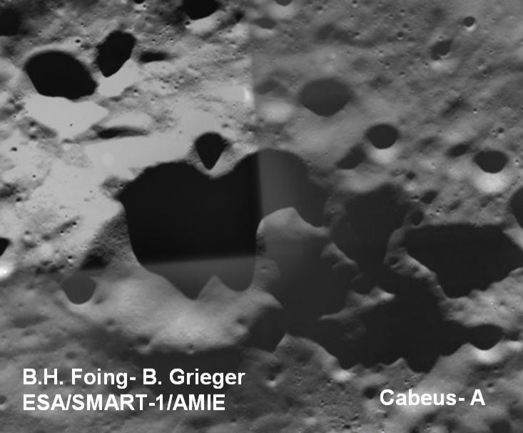
This image of LCROSS impact site Cabeus A was taken by the Advanced Moon Imaging Experiment (AMIE) on board ESA’s SMART-1 mission. The picture was taken from about 500 km, with small-field (about 50 km across) high resolution view (50 m/pixel). Image credit: B.Grieger, B.H. Foing & ESA/SMART-1/ AMIE team
[/caption]
ESA’s SMART-1 team has released an image of the future impact site of NASA’s Lunar Crater Observation and Sensing Satellite (LCROSS). The SMART-1 team searched through their database to find images of Cabeus A, where LCROSS will search for water ice by making two impacts into this crater at the lunar south pole. The impacts are scheduled for 11:30 and 11:34 am UT on 9 October 2009. This image was taken four years ago by SMART-1, a spacecraft that ended its mission in 2006 by deliberately crashing to the Moon, similar to what LCROSS will do, hoping to exhume materials buried under the lunar surface, particularly water ice. “This is like gathering evidence for a Crash Scene Investigation, but before the action takes place,” said Bernard Foing, SMART-1 project scientist.
Cabeus A is permanently shadowed, so ice lying inside the crater could be protected from the Sun’s harsh rays. LCROSS will send the upper stage Centaur rocket crashing into Cabeus A and a shepherd spacecraft will fly into the plume of dust generated and measure its properties before making a second impact with the lunar surface. Astronomers will observe both impacts using ground and space-based telescopes. The SMART-1 spacecraft also concluded its mission with a controlled bouncing impact on 3 September 2006. The event was observed with ground-based telescopes and the flash from the impact was detected at infrared wavelengths.
Foing and Bjoern Grieger, the liaison scientist for SMART-1’s AIMIE camera searched through SMART-1’s database for images of Cabeus A, taken four years ago at conditions where solar elevation and direction were similar to those of LCROSS impact. The SMART-1 image is at high resolution as the spacecraft was at its closest distance of 500 km from the South Pole.
“We are pleased to contribute these ESA SMART-1 observations of the LCROSS target site in order to help in the planning and interpretation of impact observations,” said Foing. “The coordination and exchange of information between lunar missions is an important step for future exploration of the Moon. Cooperation is vital if we are ever to see ‘villages’ of robotic landers and eventual lunar bases, as recommended by the International Lunar Exploration Working Group.”
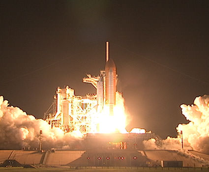
Space shuttle Discovery lifts off into the night sky on a mission to the International Space Station. Launch was on-time at 11:59 p.m. EDT. Photo credit: NASA TV
[/caption]
Russian Federal Space Agency Roscosmos head Anatoly Perminov said earlier today in Moscow that he hopes that the US space shuttle program will be prolonged, adding he has been informed of the possibility of shuttles flying beyond 2011. “We have received information from certain sources that the use of space shuttles could be extended beyond 2011,” Perminov was quoted in Interfax, adding that this information arrived through unofficial channels.
As of now, NASA plans only six more shuttle missions, with the program ending by late 2010 or early 2011 after the construction of the International Space Station (ISS) is complete.
But Perminov said he would prefer to see additional shuttle missions to the ISS.
“Then the situation would change substantially and it would be possible to work jointly with the Americans, unlike now, when the main burden (for the ISS) lies with the Russian side,” he said.
He added that NASA’s new chief and former astronaut Charles Bolden would visit Russia’s Baikonur cosmodrome on September 30 in his first foreign trip.
While the Augustine Commission review NASA’s future has only outlined a preliminary report, no strategy has been announced by NASA or the Obama administration.
The distribution of water (light blue) around a small young crater on the Moon. Credits: ISRO/NASA/JPL-Caltech/USGS/Brown Univ.
[/caption]
The Moon has been turned upside down. Figuratively, of course. La Luna still orbits and phases as it always has, but we are now looking at the moon anew. From this day forward we know the chemistry of the Moon is different than what we have thought for decades, the geology might vary from what is in textbooks today, and the physics of how the solar wind interacts with a rocky body without an atmosphere has implications not yet fully investigated. So, what does this mean for our future human and robotic exploration of our closest companion in space?
“The Moon continues to surprise us,” said Carle Pieters, principal investigator for the Moon Mineralogy Mapper (M cubed) at Thursdays press conference. “Widespread water has been detected on the surface of the Moon. You have to think outside of the box on this. This is not what any of us expected decades ago.”
Immediately, space enthusiasts’ thoughts turn to how finding water on the Moon will make future exploration there so much easier.
“Scientists thought they knew fairly accurately what the surface of the moon was like and these results show that they didn’t – or at least not completely,” said Dr. Chris Welch, astronautics and space systems expert at Kingston University in London. “Finding so much more water could make living on the moon much easier in the future…If there is water on the moon – in whatever form – then we have a potential reservoir that could be used for drinking or to make into hydrogen and oxygen which could be used as rocket propellant. Also, of course, we could use the oxygen to breathe.”
But the message the scientists wanted everyone to take away from today’s press conference is that a combination of water (H2O) and hydroxyl (OH) that resides in upper millimeter of the lunar surface doesn’t actually amount to much. The average amount of water, if extracted, is about a quart (1 liter) of water per ton of surface soil, or about 16 ounces (.5 liters) of water might be present for every 1,000 pounds (450 kg) of surface soil near the moon’s poles. For soil near the equator, only about two tablespoons of water is believed to be present in every 1,000 pounds (450 kg).
“That is truly astounding, and generating much excitement,” said Jim Green, director of the Planetary Science Division at NASA. “But please keep in mind that even the driest deserts on the Earth have more water than are at the poles and the surfaces of the moon.”
So maybe this water on the Moon is not such a big deal.
But there’s still the very real possibility that there could be water ice underneath the regolith on the Moon or buried deep within craters at the poles. Fairly recent (within the past million years) impact craters on the moon were found to have ejecta “rich” with water and hydroxyl, according to M cubed data, which implies recently those molecules are buried under the surface.
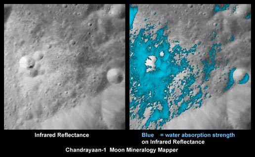
Plus the scientists hinted at data showing Goldschmidt Crater at the Moon’s north pole could be filled with water ice. The image on the left shows albedo, or the sunlight reflected from the surface of the moon. The image on the right shows where infrared light is absorbed in the characteristic manner that indicates the presence of water and hydroxyl molecules. That image shows that signature most strongly at the cool, high latitudes near the poles. The blue arrow indicates Goldschmidt crater, a large feldspar-rich region with a higher water and hydroxyl signature. Image credit: ISRO/NASA/JPL-Caltech/Brown Univ.
Additionally, what the scientists at today’s briefing found most astonishing about the new findings is that the water and hydroxyl show up at all latitudes, even at the equator in sunlight, where it is quite hot, and that there are a wide variety of hydroxyl bearing minerals at the surface. This is telling us there are some dynamic processes happening on a moon we thought to be bone dry and basically dead.
There appears to be a cycle of water being created and lost during a lunar day. Without an atmosphere, the moon is exposed to solar wind, which includes hydrogen ions. The hydrogen is able to interact with oxygen in lunar soil to create water molecules. The water appears to be created at night on the Moon, lost during the “hottest” parts of the two-week lunar day; then as it cools near evening, the cycle repeats itself. So, regardless of the type of terrain on the Moon, the entire surface of the moon will be hydrated at least for part of the day. The scientists said similar hydration effects may be present on any body in our solar system that doesn’t have an atmosphere, including asteroids and Mercury.
Those implications are huge for our explorations of other moons and worlds.
But back to the Moon. “Before this press conference, it was thought to be impossible to have water on the surface of the Moon in hot sunlight, especially on the surface at the equator,” said Roger Clark, with the M cubed and Cassini mission. Small amounts of water and hydroxyl (blue) were detected on the surface of the moon at various locations. This image illustrates their distribution at high latitudes toward the poles. Image credit: ISRO/NASA/JPL-Caltech/Brown Univ./USGS
Could water be a renewable resource on the Moon? If the water is constantly being created, could a devise be built to extract or collect the water? Easy availability of water would have an immense impact on any future human exploration on the Moon, be it brief sorties or permanent colonies.
This is intriguing,” said Pieters, “but we need to go back and re-determine this silicate surface and the vacuum around it. This is an environment we know very little about, and the physics is in its infancy.”
Discussing the implications, Pieters said first, the source of the water needs to be determined, whether it is actually from the solar wind, comets, meteorites, possibly an outgassing from the interior. “There are fundamental questions we need to understand about this silicate body,” she said. “Clearly this has to be a marriage between geology and space physics.”
And what about the “follow the water” mantra NASA has been following in regards to Mars? Could the “where there’s water, there’s life” hypothesis pertain to the Moon? Is there water on the Moon? While these new details about the Moon are groundbreaking, Welch does not believe the new findings show there is or could once have been life on the moon, but he says further research is needed. “There need to be more detailed science missions, preferably with astronauts landing on the moon, to analyse the soil in space.”
Certainly, the upcoming LCROSS impact on the Moon’s south pole will be watched with even greater interest. But what about future exploration?
Will this impel the Constellation Program to continue as planned with a return to the Moon? The Obama administration has some big decision to make in regards to NASA, and it’s hard to imagine this new information about the Moon won’t have some impact on the future path the space agency will take.
We can only hope this news brings more public and congressional interest in NASA’s future.
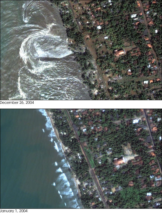
Tsunamis are some of the most devastating natural disasters. The recent Boxing Day Tsunami was generated by an enormous earthquake off the coast of Indonesia on December 26, 2004. Coastlines in Asia were inundated with enormous tsunami surges, killing more than 200,000 people.
Here are some Tsunami pictures capture by satellite that show before and after images of the regions affected by the tsunami.
[/caption]
This photograph shows the devastation that happened in Sri Lanka on December 26th. This picture was taken by the DigitalGlobe Quickbird satellite, and shows how the whole coastline was inundated with water. Devastation in Indonesia
Perhaps the most devastation from the tsunami occurred in Indonesia. This is an image of the town of Lhoknga, Indonesia. It was completely wiped off the map by the tsunami, except for the white mosque in the center of town.
Northern Sumatra
This photograph, captured by NASA’s Terra satellite shows how the whole northwest coast of the island of Sumatra was hit hard by the tsunami. It looks like the vegetation was just scraped back from the edge of the island.


 were detected on the surface of the moon at various locations. This image illustrates their distribution at high latitudes toward the poles. Image credit: ISRO/NASA/JPL-Caltech/Brown Univ./USGS")