And if you’re interested in looking back, here’s an archive to all the past Carnivals of Space. If you’ve got a space-related blog, you should really join the carnival. Just email an entry to [email protected], and the next host will link to it. It will help get awareness out there about your writing, help you meet others in the space community – and community is what blogging is all about. And if you really want to help out, sign up to be a host. Send an email to the above address.
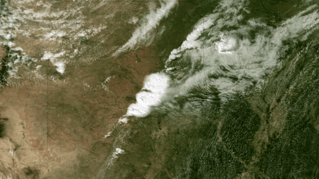
Satellite Image of Oklahoma Tornado. Acquired at 2:55 CT on May 20, 2013, this image from the NOAA GOES-13 satellite shows the storms developing directly over central Oklahoma. One minute later an incredibly destructive tornado touched down in Moore, OK. Credit: NOAA.
The massive tornado that tore through parts of Oklahoma on My 20, 2013 left a 32 km (20-mile) swath of destruction and death, with winds approaching 320 km/hr (200 mph). The US National Weather Service said the 3 km (2-mile)-wide tornado spent 40 minutes on the ground in the area of Moore, Oklahoma, outside of Oklahoma City, destroying schools, a hospital and hundreds of homes, killing dozens of people. Satellite images and video show how the storm developed.
Below is a video showing satellite imagery from the GOES 13 satellite from May 19-20, 2013. It shows the tornado outbreak and supercell thunderstorms that developed across portions of the Great Plains:
Weather satellites help scientists to observe weather patterns from the unique vantage point of space. This provides the ability to see a larger area of the Earth rather than with conventional radar which does not reveal a true overview of cloud structure and wind patterns.
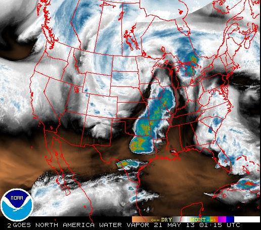
These satellites can measure many different things, such as in the image below, which looks at water vapor content of the clouds. The satellites operated by NASA and NOAA and are equipped to send back images in infrared and other wavelengths, providing snapshots of things like the water vapor measurements, temperatures, wind patterns, cloud coverage, storm movement and many other readings. This information also helps with the prediction of storms, allowing for warnings for people to seek shelter from potentially destructive weather events.
This screenshot shows a false color view of the water vapor content in the clouds during the tornado outbreak in Oklahoma on May 20, 2013, as seen from NOAA geostationary (GOES) satellites. Click on image to go to current NOAA imagery.
The news from Oklahoma is ongoing, and we encourage you to keep current on the latest information from other news sites. But as Phil Plait pointed out, if you are interested in helping the people involved in this tragedy, the Take Part website has a list of organizations that are in the area providing support.
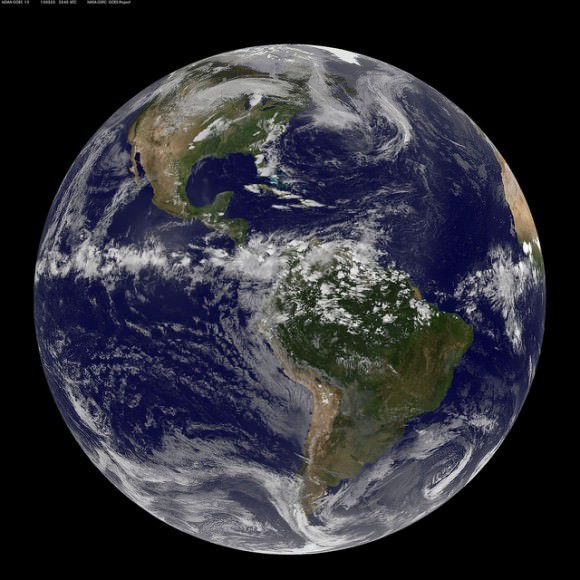
This full-disk view of Earth shows the formation of the Oklahoma tornado, from the Aqua satellite. Credit: NASA Goddard Space Flight Center.
As the first eclipse season of 2013 comes to an end this weekend, an extremely subtle lunar eclipse occurs on the night of Friday, May 24th going into the morning of Saturday, May 25th. And we do mean subtle, as in invisible to the naked eye… this eclipse only lasts 34 minutes in duration and less than 2% of the disk of the Moon enters the bright outer penumbra of the Earth’s shadow!
So, why talk about such a non-event at all?
Great things come from such humble beginnings. And while this weekend’s eclipse is one mostly for the almanacs and astronomical tables rather than a true observational event, it also marks the start of a new lunar saros cycle.
This weekend’s eclipse is one of five for 2013, a year which contains two solars and three lunars. This eclipse marks the end of the first “eclipse season” of the year, a time when the intersection of the Moon’s orbit (known as nodes) and the ecliptic nearly coincide with the position of the Sun (for a solar eclipse at New Moon) and the Earth’s shadow (for a lunar eclipse at Full Moon).
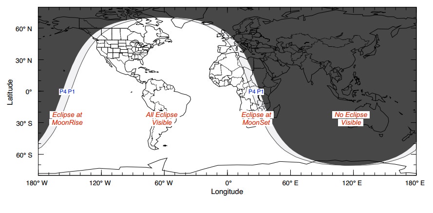
The current season began with a very slight partial eclipse on April 25th, followed by an annular eclipse on May 10th. It will last only 33 minutes and 45 seconds in duration starting at 03:53:11 UTC on May 25th. The Moon will be high over the Americas at the time, but again, shading on the southern limb of the Moon will be too slight to be seen.
Curiously, SLOOH will be providing live coverage of the eclipse, although again, it will be too slight to see.
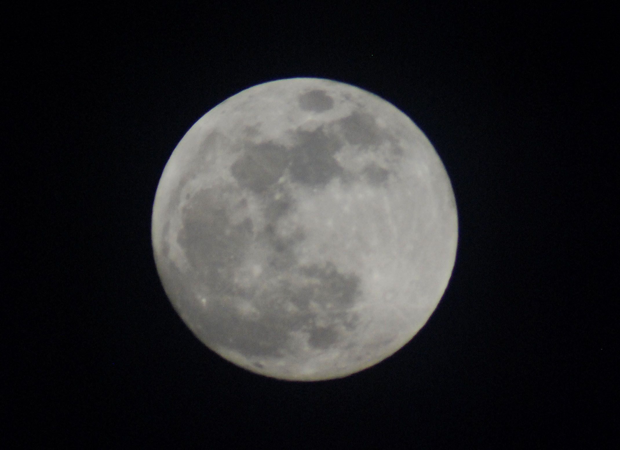
The Full Moon just nicks the Earth’s penumbra in the early morning hours of May 25th. (Created by the author in Starry Night).
What is a saros? A saros is a period of 18 years 11 days and 8 hours after which an eclipse cycle lines up, producing a similar eclipse to the one that preceded it 18 years before. Note that due to its 8 hour offset, the Earth will have rotated 120° and the visibility region will have shifted westward.
In said period, three lunar cycles very nearly line up;
The Anomalistic month (the period the Moon takes to go from one perigee to another) = 27.555 days.
The Draconic month (the period the Moon takes to return to the same node) = 27.212 days.
The Synodic month (the most familiar one, the period between similar phases) = 29.531 days.
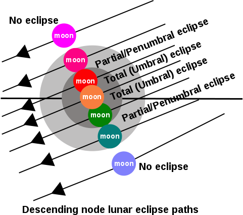
There’s that mis-alignment of a third of a day again (8 hours) for every 18 years and 11 days. This also causes the node of each eclipse in the cycle to drift eastward by 0.5° along the ecliptic. Thus, each eclipse isn’t exactly the same. A lunar saros series starts with a very brief penumbral like this weekend’s, becomes deeper and deeper every 18+ year period until partial and total eclipses begin centuries down the road. Thereafter, the cycle reverses, until a final faint penumbral marks the end of the lunar saros.
The progression of selected eclipses of the same saros cycle. (Credit: Matthew Zimmerman. Wikimedia Commons graphic in the Public Domain).
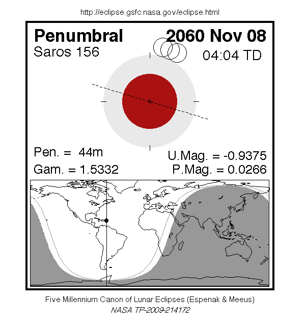
After this weekend’s eclipse, the next start of a lunar saros won’t occur until November 8th 2060 with the start of saros 156. The last new saros series (number 149) began on June 13th, 1984.
There are numbered saros series for both lunar and solar eclipses. There are currently 41 saroses (the plural of saros) active with the inclusion of this weekend’s start of lunar saros 150.
Saros 150, of which this eclipse is the 1st of 71, will last for just over 1,262 years. It will begin to produce partial eclipses on August 20th, 2157 and produce its 1st total on its 32nd lunar eclipse on April 29th, 2572.
It amazes me that ancient cultures such as the Chaldeans new of saros cycles and could predict eclipses. Being geographically isolated, lunar eclipse cycles would have been easier to decipher than solar ones, as you only have to be on the Moonward facing hemisphere of the Earth to witness the eclipse. They may well have stumbled upon the saros while attempting to calculate a slightly longer 19 year period known as a Metonic cycle to align ancient luni-solar calendars.
And yes, that 8 hour offset also means that after a triple saros period, lunar and solar eclipses of the same saros series do return to roughly the same longitude every 54 years & 34 days. This is known as an exeligmos, and if you get this on a triple-word score in Scrabble, you can safely retire from the game.
The theoretical visibility circumstances for this week’s penumbral eclipse. (Credit: F. Espenak/NASA/GSFC).
And while this eclipse is more of academic than observational interest, you can always enjoy the light of a brilliant Full Moon. The May Full Moon is referred to as the Flower, Milk, and Corn Planting Moon by the Algonquian Indians of North America, alluding the latent season of Spring.
Also, keep an eye out for several conjunctions and occultations this week by the Moon with bright stars and planets.
The first up is the bright star Spica (Alpha Virginis) which gets occulted by the waxing gibbous Moon around ~11:00 UT on Wednesday, May 22nd for viewers across northern Australia, southern Asia and the South Pacific. Spica is one of four stars brighter than magnitude +1.5 that the Moon can occult, the others being Antares, Aldebaran and Regulus. This is the 6th occultation in a cycle of 13 of Spica by the Moon spanning 2013.
The planet Saturn will lie about 4° north of the waxing gibbous Moon on the following evening of May 23rd.
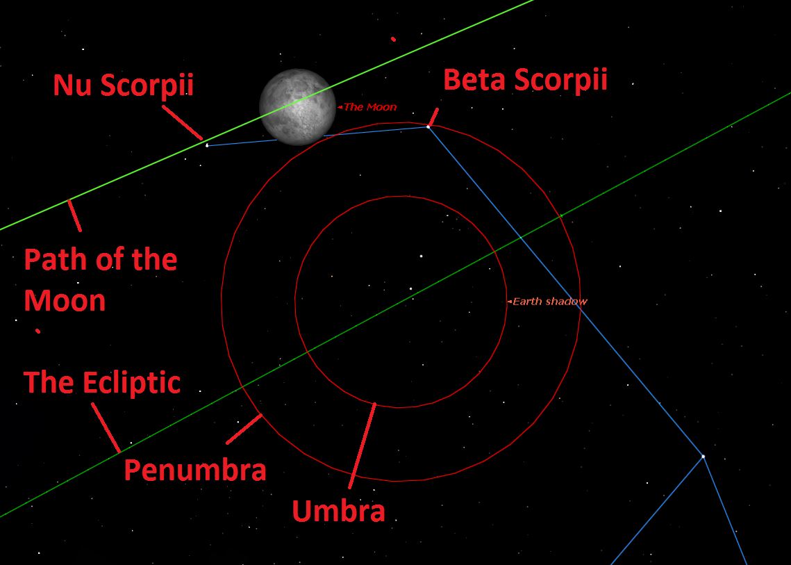
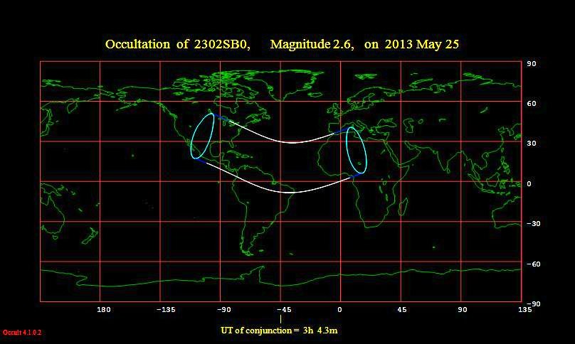
Also, watch for an occultation of the +2.6th magnitude star Beta Scorpii on the evening of May 24th around the time of the lunar eclipse. This will be a difficult one, as the Moon will be near 100% illumination. Conjunction of the Moon and Beta Scorpii in right ascension occurs at 3:04 UT on May 25th, about 2.5 hours after Full. The occultation will span the southeastern US, Caribbean, northern South America and western Africa.
Visibility path of the occultation of Beta Scorpii by the Moon. (Credit: Occult 4.1.0.2).
2013 isn’t a grand year for eclipses. We’ve got two more in the late season of the year, another slightly deeper penumbral on October 18th and a hybrid solar eclipse on November 3rd. And when, may you ask, will we FINALLY have another total lunar eclipse? Stick around ‘til U.S. Tax Day next year (April 15th 2014) for a total lunar eclipse spanning the Americas!
Artist's conception of the solar system, often used in the Eyes on the Solar System 3D Simulator. Credit: NASA
Venus and Mars may be all right tonight, but there’s still a lot we don’t understand about these planets. Why does one, Venus, have such a thick atmosphere? Why is that of Mars so thin? And why is Earth’s atmosphere so different again from what we see on Venus and Mars?
A new JAXA (Japan Aerospace Exploration Agency) satellite aims to better understand what’s going on. It’s called SPRINT-A, for Spectroscopic Planet Observatory for Recognition of Interaction of Atmosphere.
JAXA has set an official launch date of Aug. 22 from the Uchinoura Space Center, although the window extends as far as Sept. 30. (Launches can be delayed due to weather and mechanical difficulties.) The satellite’s expected Earth orbit will range from 590 to 715 miles (950 to 1150 kilometers) above the planet.
“Venus and Earth may be called twin planets, and it recently becomes clear that three terrestrial planets in the solar system – including Mars – have very similar environments in the beginning era of the solar system,” JAXA stated in a press release.
Earth’s atmosphere was similar to that of Venus and Mars in the early solar system, but now it’s quite different, says JAXA. (Image: NASA/Suomi NPP)
The agency pointed out, however, that these three planets ended up with different fates. Venus has a runaway greenhouse effect on its planet, with surface temperatures reaching a scorching 752 degrees Fahrenheit (400 degrees Celsius). Mars, on the other hand, has a very thin atmosphere and more variable temperatures that can get a little chilly.
Understanding how atmospheres escape into outer space is the main goal of SPRINT-A. The sun, the scientists stated, had more intense activity in the past than what we see presently, which could have blown away the atmosphere on some terrestrial planets.
“The study on interaction of the strong solar wind on the atmosphere of the planet leads to acquiring knowledge of history in the early stage of the solar system,” JAXA stated.
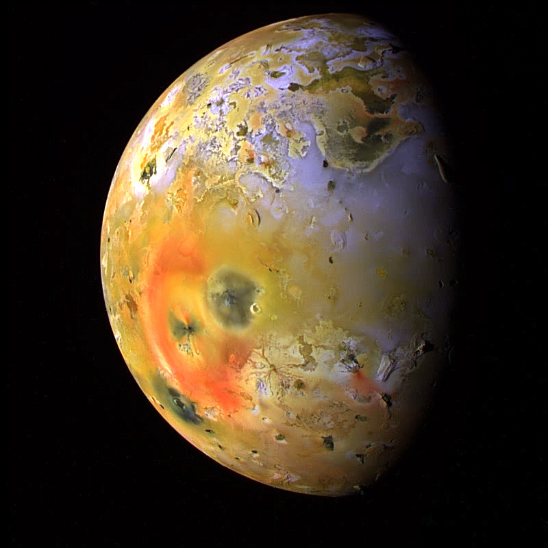
Besides looking at the inner solar system, SPRINT-A will investigate a phenomenon related to a splotchy volcanic moon orbiting the planet Jupiter.
Io, a moon of Jupiter. The colors in this image have been enhanced to better show differences. Sulfur dioxide frost appears in white and grey, and other types of sulfur are in yellow and brown. Recent volcanic activity is marked by red and black blotches. Credit: NASA
SPRINT-A aims to better understand a ring of material surrounding Jupiter that came from Io.
Electrons and ions from the volcanic moon surround Jupiter and, as they collide, produce ultraviolet light in a process similar to what causes auroras in the upper atmosphere of Earth and other planets. How this happens is still being figured out, though.
It’s a pretty radiation-heavy environment in that region of the solar system. The spacecraft Galileo safely orbited the Jovian moons for years, but humans would have a little more trouble surviving the radiation without heavy shielding and careful precautions.
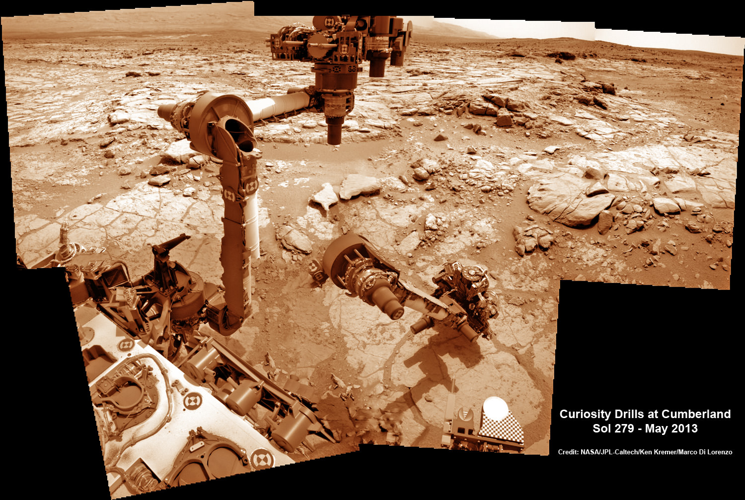
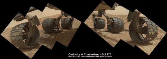
This time lapse mosaic shows Curiosity moving her robotic arm to drill into her 2nd rockt target named “Cumberland” to collect powdery material on May 19, 2013 (Sol 279) for analysis by her onboard chemistry labs; SAM & Chemin. The photomosaic was stitched from raw images captured by the navcam cameras on May 14 & May 19 (Sols 274 & 279). Credit: NASA/JPL-Caltech/Ken Kremer/Marco Di Lorenzo
NASA’s Curiosity rover has just successfully bored inside ancient rocks on Mars for only the 2nd time since her nail biting landing in August 2012 inside Gale Crater as she searches for the ingredients of life.
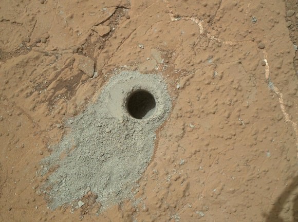
On Sunday, May 20, the rover drilled about 2.6 inches (6.6 centimeters) deep into a target named “Cumberland” to collect powdery samples from the rock’s interior that hold the secrets to the history of water and habitability on the Red Planet.
“Cumberland” is literally just a stone’s throw away from the first drill target named “John Klein” where Curiosity bored the historic first drill hole on an alien world three months ago in February.
NASA’s Mars rover Curiosity drilled into this rock target, “Cumberland,” during the 279th Martian day, or sol, of the rover’s work on Mars (May 19, 2013) and collected a powdered sample of material from the rock’s interior. Analysis of the Cumberland sample using laboratory instruments inside Curiosity will check results from “John Klein,” the first rock on Mars from which a sample was ever collected and analyzed. The two rocks have similar appearance and lie about nine feet (2.75 meters) apart. Image Credit: NASA/JPL-Caltech/MSSS
Analysis of the gray colored, powdery “John Klein” sample by Curiosity’s pair of onboard chemistry labs – SAM & Chemin – revealed that this location on Mars was habitable in the past and possesses the key chemical ingredients required to support microbial life forms – thereby successfully accomplishing the key science objective of the mission and making a historic discovery.
The Cumberland powder will be fed into SAM and Chemin shortly through a trio of inlet ports on the rover deck.
‘Cumberland’ lies about nine feet (2.75 meters) west of ‘John Klein’. Both targets are inside the shallow depression named ‘Yellowknife Bay’ where Curiosity has been exploring since late 2012.
The six wheeled NASA robot arrived at Cumberland just last week on May 14 (Sol 274) after a pair of short drives.
6 Wheels on Mars at “Cumberland” drill target is shown in this photo mosaic of Curiosity’s underbelly snapped on May 15, 2013 (Sol 275) after the rover drove about 9 feet (2.75 m) from the John Klein outcrop inside Yellowknife Bay. Credit: NASA/JPL-Caltech/Ken Kremer/Marco Di Lorenzo
The science team directed Curiosity to drill into ‘Cumberland’ to determine if it possesses the same ingredients found at “John Klein” and whether the habitable environment here is widespread and how long it existed in Mars’ history.
“We’ll drill another hole [at Cumberland] to confirm what we found in the John Klein hole,” said John Grotzinger to Universe Today. Grotzinger, of the California Institute of Technology in Pasadena, Calif., leads NASA’s Curiosity Mars Science Laboratory mission.
“The favorable conditions included the key elemental ingredients for life, an energy gradient that could be exploited by microbes, and water that was not harshly acidic or briny,” NASA said in a statement.
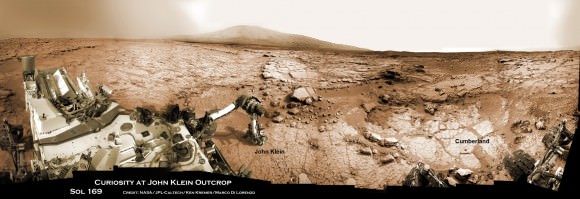
Panoramic view of Yellowknife Bay basin back dropped by Mount Sharp shows the location of the first two drill sites – John Klein & Cumberland – targeted by NASA’s Curiosity Mars rover. Curiosity accomplished historic 1st drilling into Martian rock at John Klein outcrop on Feb 8, 2013 (Sol 182) near where the robotic arm is touching the surface. This week the rover scooted about 9 feet to the right to Cumberland (right of center) for 2nd drill campaign on May 19, 2013 (Sol 279). Credit: NASA/JPL-Caltech/Ken Kremer/Marco Di Lorenzo
‘Cumberland’ and ‘John Klein’ are patches of flat-lying bedrock shot through with pale colored hydrated mineral veins composed of calcium sulfate and featuring a bumpy surface texture inside the ‘Yellowknife Bay’ basin that resembles a dried out lake bed.
“We have found a habitable environment [at John Klein] which is so benign and supportive of life that probably if this water was around, and you had been on the planet, you would have been able to drink it,” said Grotzinger.
Curiosity will remain at Cumberland for several weeks to fully characterize the area and then continue exploring several additional outcrops in and around Yellowknife Bay.
“After that we’re likely to begin the trek to Mt. Sharp, though we’ll stop quickly to look at a few outcrops that we passed by on the way into Yellowknife Bay,” Grotzinger told me.
One stop is likely to include the ‘Shaler’ outcrop of cross-bedding that was briefly inspected on the way in.
Thereafter the 1 ton rover will resume her epic trek to the lower reaches of mysterious Mount Sharp, the 3.5 mile (5.5 km) high layered mountain that dominates her landing site and is the ultimate driving goal inside Gale Crater.
And don’t forget to “Send Your Name to Mars” aboard NASA’s MAVEN orbiter- details here. Deadline: July 1, 2013
Video Caption: This JPL video shows the complicated choreography to get drill samples to Curiosity’s science instruments after completing 2nd drill campaign at “Cumberland.”
Cottonwood trees and the Milky Way on May 12, 2013. Credit and copyright: Randy Halverson/Dakotalapse.
Admittedly, I’m partial to Randy Halverson’s night sky photography from South Dakota. Having grown up in neighboring North Dakota myself, Halverson’s images bring back memories of the dark skies that grace the northern plains. But this one is just stunning, not to mention my early childhood home was surrounded by cottonwood trees — towering giants with ample limbs, and one of the few trees that grew well in the harsh prairies of the Dakotas.
Randy said he was trying out some new gear with this image, which is a frame from a timelapse he is shooting (can’t wait!) He used ased a Canon 6D and a Rokinon 24mm F1.4 lens (set at F2), using Emotimo TB3 Black timelapse equipment, shot at ISO 3200 for 20 seconds.
Want to get your astrophoto featured on Universe Today? Join our Flickr group or send us your images by email (this means you’re giving us permission to post them). Please explain what’s in the picture, when you took it, the equipment you used, etc.
This article originally appeared in 2009, but I’ve updated it and added this video.
The ground feels firm and solid beneath your feet. Of course, the Earth is rotating, turning once on its axis every day. Fortunately gravity keeps you firmly attached to the planet, and because of momentum, you don’t feel the movement – the same way you don’t feel the speed of a car going down the highway. But how fast does the Earth rotate?
You might be surprised to know that a spot on the surface of the Earth is moving at 1675 km/h or 465 meters/second. That’s 1,040 miles/hour. Just think, for every second, you’re moving almost half a kilometer through space, and you don’t even feel it.
Want to do the calculation for yourself? The Earth’s circumference at the equator is 40,075 km. And the length of time the Earth takes to complete one full turn on its axis is 23.93 hours.
Wait, 23.93 hours? Isn’t a day 24 hours? Astronomers calculate a day in two ways. There’s the amount of time it takes for the Earth to complete one full rotation on its axis, compared to the background stars. Imagine you were looking down at the Earth from above the North Pole. You’d see the Earth turn once completely in 23 hours and 56 minutes. Astronomers call this a sidereal day.
And then there’s the time it takes for the Sun to return to the same spot in the sky. Since the Earth is orbiting the Sun, we actually need an extra 4 minutes each day to return the Sun to the same spot. Astronomers call this a solar day.
Then we divide the length of a day into the distance a point on the equator travels in that period: 40,075 km/23.93 hours = 1,675 km/hour, 465 meters/second.
The speed of the Earth’s rotation changes as you go North or South away from the equator. Finally, when you reach one of the Earth’s poles, you’re taking a whole day to just turn once in place – that’s not very fast.
Because you’re spinning around and around on the Earth, there’s a force that wants to spin you off into space; like when you spin a weight on a string. But don’t worry, that force isn’t very strong, and it’s totally overwhelmed by the force of gravity holding you down. The force that wants to throw you into space is only 0.3% the force of gravity. In other words, if the Earth wasn’t spinning, you would weigh 0.3% more than you do right now.
Space agencies take advantage of the higher velocities at the Earth’s equator to launch their rockets into space. By launching their rockets from the equator, they can use less fuel, or launch more payload with the same amount of fuel. As it launches, the rocket is already going 1,675 km/hour. That makes it easier to reach the 28,000 km/hour orbital velocity; or even faster to reach geosynchronous orbit.
We have written many articles about the Earth for Universe Today. Here’s an article about why the Earth rotates.
A menagarie of animals launched to space last month has arrived back on Earth — with a few casualties for the voyage.
Bion-M, a small satellite carrying gerbils, lizards, mice and other critters, launched in April from the Plesetsk Cosmodrome in Russia and arrived, as planned, safely on Earth on Sunday (May 19).
However, not all of the assorted crew survived the voyage.
“This is the first time that animals have been put in space on their own for so long,” said Vladimir Sychov of the Russian Academy of Sciences, as reported by several news agencies. Half of the 45 mice were lost in the journey, which was expected, but the eight gerbils unexpectedly died “because of equipment failure”, he added.
The Bion-M hardware is readied for flight. Credit: Russian Federal Space Agency (Roscosmos)
Still, the scientists expect to pull a lot of long-duration data out of the mission. It is expected to help scientists better understand the effects of microgravity on biological organisms, with applications for long human voyages such as a trip to Mars.
Microgravity does a number on human systems, as just-returned-from-space astronaut Chris Hadfield eloquently described recently.
Bones lose calcium, muscles shrink and there are changes to your blood pressure flow and even your eyes. Taking a trip to space is like experiencing aging on fast-forward (although luckily, the effects are mostly reversible.)
Michael Foale on the ISS’s treadmill. Astronauts on station exercise two hours a day, typically, to fight against microgravity’s effects. Credit: NASA
“Knowledge gained in the use of animals reveals the fundamental mechanisms of adaptation to spaceflight,” NASA stated in a web page about the mission. “Such knowledge provides insight for potential long-duration human spaceflight risk mitigation strategies and potential new approaches for Earth bound biomedical problems.”
Before Bion-M journeyed to space, most mouse studies only took place during space shuttle missions that were in orbit for a maximum of two weeks. The new 30-day mission doubled the length of previous studies and also allow more advanced technologies to be brought to bear on the science, stated NASA, who participated in the mission.
“NASA researchers will study the cellular mechanisms responsible for spaceflight-induced changes on tissues and cell growth in mice, including muscle, bone and the cardiovascular and reproductive systems,” the agency wrote in an April press release. “They also will study behavioral effects in gerbils.”
Image from May 5, 2013 of a the inner region of Comet ISON using the 2-meter Liverpool telescope at La Palma. Credit: Nick Howes and Ernesto Guido, Remanzacco Observatory; Nalin Samarasinha, Planetary Science Institute.
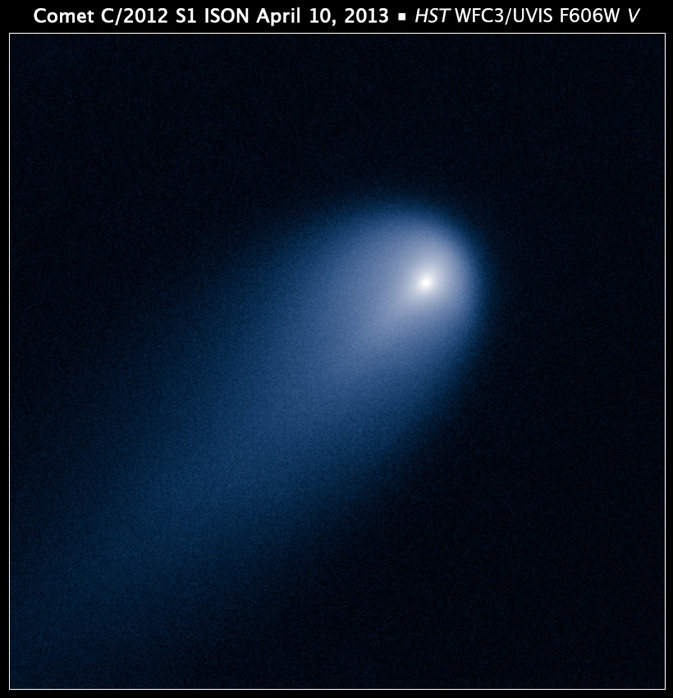
In April, when the Hubble Space Telescope looked out towards Jupiter’s orbit and observed what has been billed as the “Comet of the Century” – Comet C/2012 S1 ISON – the space telescope photographed a unique feature in the comet’s coma. Now, a team of ground-based astronomers have performed follow-up observations, imaging Comet ISON as it heads towards the Sun and was just outside the orbit of Mars. They, too, have seen something in the coma and suspect it’s a similar feature to what Hubble imaged. The object is thought to be a jet blasting dust particles off the sunward-facing side of the comet’s nucleus.
These very useful follow-up observations are providing more insight on this highly anticipated comet, as well as helping to predict what might happen when it makes its closest approach to the Sun in November 2013.
“The hype surrounding this comet has been extreme” said Nick Howes from the Remanzacco Observatory, “with some wildly optimistic estimates for magnitude. We’re hoping this measured scientific approach will yield results just as exciting to the science community, even if the comet doesn’t end up meeting everyone’s expectations visually, for whatever reason.”
NASA’s Hubble Space Telescope provides a close-up look of Comet ISON (C/2012 S1), as photographed on April 10, when the comet was slightly closer than Jupiter’s orbit at a distance of 386 million miles from the sun. Credit:NASA, ESA, J.-Y. Li (Planetary Science Institute), and the Hubble Comet ISON Imaging Science Team.
Some have predicted ISON may briefly become brighter than the full Moon. But right now the comet is far below naked-eye visibility, and larger telescopes are needed to makes observations.
Howes and Ernesto Guido from the Remanzacco Observatory in Italy used a suite of Hubble-sized ground-based telescopes in Australia, Hawaii and the Canary Islands to make their observations. They are collaborating with with Nalin Samarasinha, a Senior Scientist at the Planetary Science Institute (PSI) in an attempt to get high spatial resolution data on Comet ISON.
Howes and Guido have been imaging Comet C/2012 S1 ISON since the day it was discovered and actually played a small role in its discovery. They work on a variety of programs with professional and amateur astronomers around the world, but for this comet, their focus is on the so-called Afrho, a measure of a comet’s dust production. (Learn more about Arfho here.)
Samarasinha, a specialist in comets at the Planetary Science Institute, has been looking at the detailed structure of the near-nucleus coma of comet C/2012 S1 ISON using data, which the Remanzacco team is delivering in to the PSI.
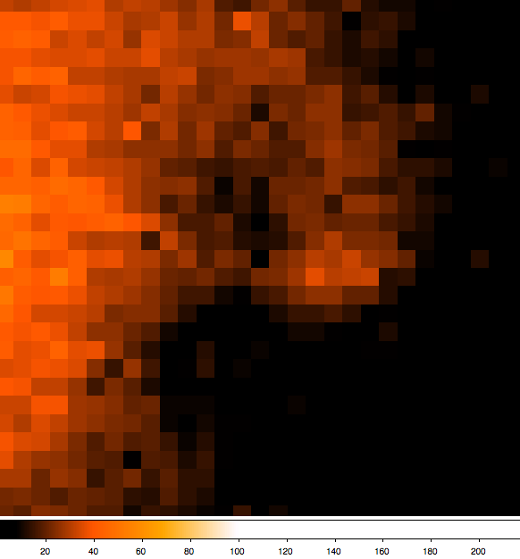
Recently, Samarasinha had looked at image comparisons for the Remanzacco team’s dataset from May 2, 5, and 7 taken with the F10 2-meter Liverpool telescope on La Palma, using an extremely sensitive camera, perfectly suited for detailed comet work.
Image from May 2, 2013 of a the inner region of Comet ISON, using the 2 meter Liverpool Telescope at La Palma. Credit: Nick Howes and Ernesto Guido, Remanzacco Observatory; Nalin Samarasinha, Planetary Science Institute.
The images shown here are 28×28 pixel crops of the inner region of the comet.
“This comparison shows that the sunward feature Nick’s team suspected from images taken on 02/05/2013 is originating slightly north of west and then the position angle of the feature (measured from north through east) increases as one moves away from the optocenter,” said Nalin.
Nalin’s interpretation is that the curvature of this feature (which the team suspected was not caused by image enhancing initially, but can now categorically state is real) is not due to any rotational effects but is due to radiation pressure pushing dust grains towards the tail. Ultimately, this feature merges in with the tail. Image from May 7, 2013 of a the inner region of Comet ISON, as seen with the 2-meter Liverpool Telescope at La Palma. Credit: Nick Howes and Ernesto Guido, Remanzacco Observatory; Nalin Samarasinha, Planetary Science Institute.
The team says these observations are in close agreement with features detected by the Hubble Space Telescope in April this year. As the comet comes closer to the Earth the spatial resolution will improve, and the team should get more detailed views on the coma structure.
Estimates suggest that the nucleus of ISON is no larger than 4-6 km (3-4 miles) across while the comet’s dusty coma, or head of the comet is approximately 5,000 km (3,100 miles) across, or 1.2 times the width of Australia. A dust tail extends more than 92,000 km (57,000 miles).
Ongoing observations seem to reveal this comet is ‘shedding’ quite a bit of mass, leaving astronomers to wonder if it will have enough body left to survive its perhihelion, the closest approach to the Sun on November 28, 2013.
Excitingly, Comet ISON observations are in the works for when the comet dashes past Mars, and the Curiosity rover is on tap to try imaging it from Mars’ surface with its high resolution Mastcam 100 camera, as well as on-orbit observations with the Mars Reconnaissance Orbiter (MRO).
As the comet performs a hairpin turn around the Sun in November, its ices will vaporize in the intense solar heat. Assuming it defies death by evaporation, some predict it could become as bright as the full Moon. If so, that would occur for a brief time around at perihelion when the comet would only be visible in the daytime sky very close to the Sun. When safely viewed, ISON might look like a brilliant, fuzzy star in a blue sky.
As C/2012 S1 ISON is now heading in to the evening twilight glare, Howes and Guido will turn from large aperture instrumentation on this comet for a while, and work on observations with a wider field CCD, more sensitive in the R’ band, and also imaging with the Polarimeter instrument which will allow them to create detailed maps of the inner coma region.
Howes said that these ongoing collaborations with scientists with the amateur community are delivering valuable scientific data on a hugely interesting object.
Nighttime image of southern India and Tropical Cyclone Mahasen (NASA/NOAA)
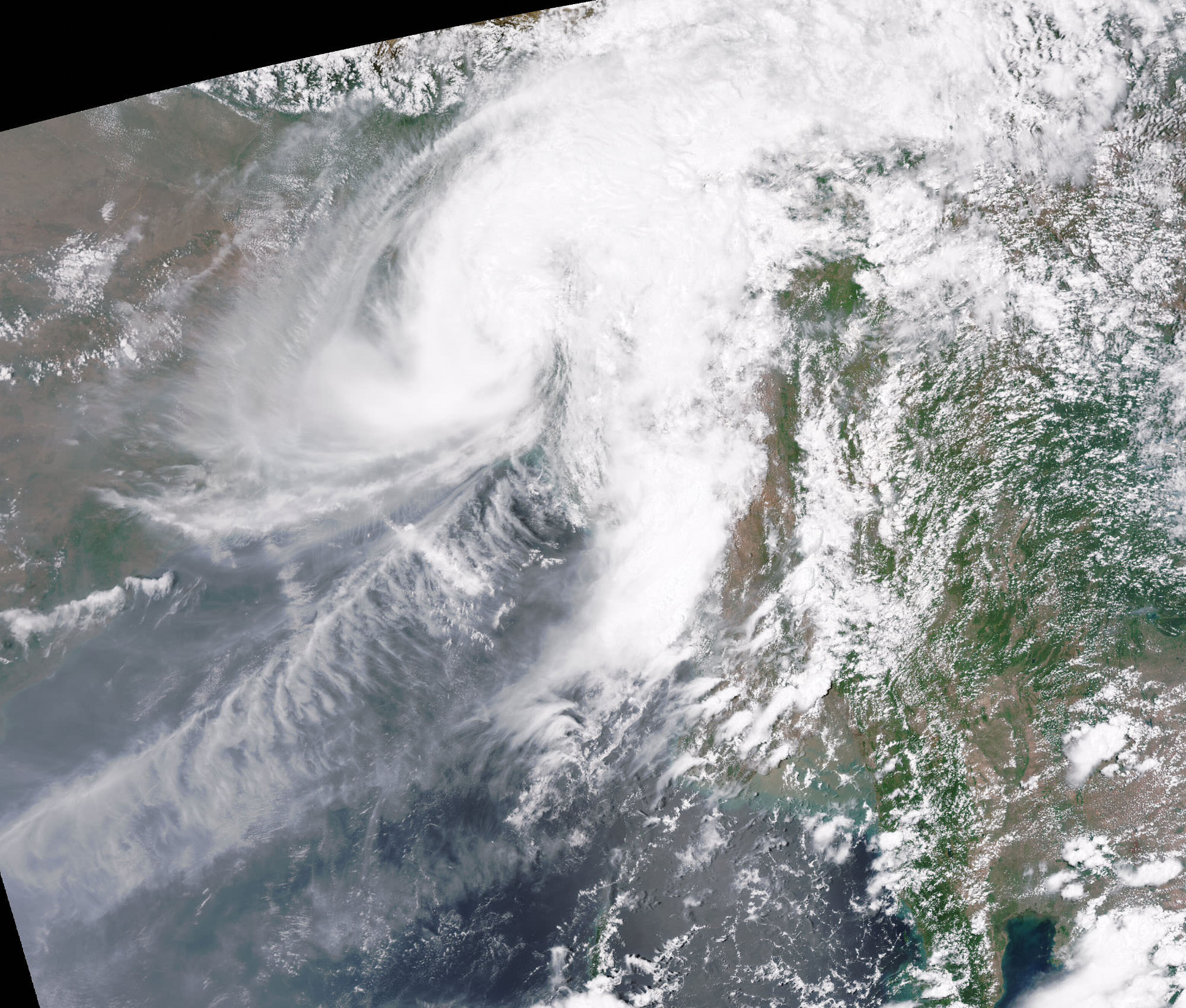
Last Monday, May 13, the Suomi NPP satellite captured a fascinating image of Tropical Cyclone Mahasen as it moved northeast over the Bay of Bengal. The clouds of the storm itself weren’t optically visible in the darkness of a nearly new Moon, but lightning flashes within it were… as well as the eerie ripples of atmospheric gravity waves spreading outwards from its center.
According to the Space Physics Research Group at the University of California, Berkeley:
Gravity waves are the oscillations of air parcels by the lifting force of bouyancy and the restoring force of gravity. These waves propagate vertically as well as horizontally, and actively transport energy and momentum from the troposphere to the middle and upper atmosphere. Gravity waves are caused by a variety of sources, including the passage of wind across terrestrial landforms, interaction at the velocity shear of the polar jet stream and radiation incident from space. They are found to affect atmospheric tides in the middle atmosphere and terrestrial weather in the lower atmosphere. (Source)
Atmospheric gravity waves aren’t to be confused with gravitational waves in space, which are created by very dense, massive objects (like white dwarf stars or black holes) orbiting each other closely.
When the image was captured, Tropical Cyclone Mahasen was moving north through the Indian Ocean along a track that placed landfall along the Bangladesh coast. As it moved off the coast of India Suomi’s VIIRS Day-Night Band was able to resolve lightning flashes towards the center of the storm, along with mesopheric gravity waves emanating outwards like ripples in a pond.
Such gravity waves are of particular interest to air traffic controllers so assist in identifying areas of turbulence.
Since the moon was in a new phase, the lights and other surface features of India and Sri Lanka are clearly visible although the clouds of Mahasen are not — a tradeoff that occurs as the amount of moonlight cycles throughout the month.
TS Mahasen on May 17, 2013 (Chelys/EOSnap)
Over the course of the next few days Mahasen weakened into a deep depression, making landfall as a tropical storm on Bangladesh on May 16. In preparation for the storm large-scale evacuations were recommended for parts of Myanmar; however, this resulted in the overcrowding of boats and several vessels capsized. (Source: eosnap.com)
NASA launched the National Polar-orbiting Operational Environmental Satellite System Preparatory Project (or NPP) on October 28, 2011 from Vandenberg Air Force Base. On Jan. 24, NPP was renamed Suomi National Polar-orbiting Partnership, or Suomi NPP, in honor of the late Verner E. Suomi. It’s the first satellite specifically designed to collect data to improve short-term weather forecasts and increase understanding of long-term climate change.
Suomi NPP orbits Earth about 14 times a day, observing nearly the entire surface of the planet.


