Chinese Moon Mission Blasts Off

2007-1024change1.thumbnail.jpg

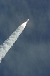
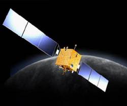
The Moon had been lonely for a while, but now there’s no shortage of spacecraft on the way. The latest visitor, China’s Chang’e-1, blasted off today from the Xichang Satellite Launch Centre, Sichuan, atop a Long March 3A rocket. Although this spacecraft is just a lunar orbiter, it begins the country’s journey to putting a lander down on the surface of the Moon before 2020.

Just like the Japanese spacecraft already orbiting the Moon, and the upcoming US Lunar Reconnaissance Orbiter, this Chinese spacecraft will studying the Moon in detail.

It has four major objectives: to map the Moon’s surface in 3-D, to analyze the abundance of 14 chemical elements, to measure the depth of the lunar soil (or regolith), and to study the space weather between the Earth and the Moon.

The ambitious spacecraft weighs in at 2,350 kg, and will transition to a low, circular lunar orbit, skimming just 200 km above the surface. It’s expected to begin its Earth-Moon transfer burn on October 31st, and arrive in lunar orbit on November 5th. It’s expected that Chang’e-1 will take its first images on the Moon in late November, and continue scientific observations for a year.

Original Source: ESA News Release

Kaguya Releases Its Second Baby Satellite

2007-1012vrad.thumbnail.jpg

As we mentioned in past articles, the Japanese Kaguya spacecraft, now orbiting the Moon, is actually a collection of satellites. The largest satellite is Kaguya. It’s the one equipped with all the cameras and the suite of scientific instruments.

But Kaguya was also carrying two baby satellites. The first Relay satellite, nicknamed Okina, was released on October 9th. Today Kaguya released its second sub-satellite: the tiny Very Long Baseline Interferometer (or VRAD). VRAD’s job will be to help Kaguya carefully map out the Moon’s gravity field.

Original Source: JAXA News Release

First Pictures From Kaguya

2007-1010moon.thumbnail.jpg

The Japanese space agency JAXA has confirmed that their lunar orbiter Kaguya (aka Selene) is now firmly in orbit around the Moon. That was quick. The agency released this image captured by Kaguya’s high-gain antenna motor camera showing its new home.

The spacecraft isn’t due to take photographs with its full suite of scientific instruments until it reaches its final science orbit later this month. This image was captured by the antenna motor, which just happens to have a view of the Moon in the background. Don’t worry, the images are going to get much, much better.

By the time Kaguya is in its final science orbit, it will be able to capture images of the lunar surface at a resolution of 1-metre. It will also be recording high-definition television images of the surface, which should look just amazing in the eventual documentaries.

Original Source: JAXA News Release

Lunar Probe’s High Definition View of the Earth

2007-1003earth.thumbnail.jpg

There’s nothing as nice as a pretty view of our home planet. It really puts things in perspective. I’m on that planet, and so are you. It’s a high definition image of the Earth, of course, captured on September 29th by the Japanese spacecraft Kaguya (aka Selene) from a distance of 110,000 km. It’s currently in Earth-orbit, but on October 3rd, it’ll begin transferring its orbit to the Moon.

As to the actual mission, here’s an article we posted a couple of weeks ago, when the spacecraft was launched. We’ll report back with further updates, for now, just enjoy the pretty picture.

Original Source: JAXA News Release

Carnegie Mellon’s New Prototype Lunar Rover

2007-923.thumbnail.jpg

Consider this: there are two rovers crawling around the surface of Mars. Isn’t it strange that we don’t have anything similar on the surface of the Moon. I mean, come on, it’s so close. Well, researchers at Carnegie Mellon are working to fix this problem. They’ve been tasked by NASA to develop a prototype lunar rover. One which can travel in the low lunar gravity, and hang on tight when it needs to drill down beneath the lunar soil.

The prototype lunar rover is called “Scarab”, and it’s being built by the Robotics Institute of Carnegie Mellon University’s School of Computer Science. Even though it’s being built to test out technologies designed for the surface of the Moon, this little rover will never make the trip. But its advances will be incorporated into future technologies for real missions.

Traveling around the Moon is going to be hard. Especially when you’re searching for water inside the perpetually darkened craters at the lunar southern pole. You’ve got regions of perpetual darkness at the lunar poles, where temperatures plunge to hundreds of degrees below zero. Instead of the traditional solar panels, Scarab will use a radioisotope source to generate energy.

It won’t get much power, though, probably less than the amount required to operate a 100-watt light bulb. This means that the rover will be operating in nearly complete darkness, relying on low-power, laser-based sensors. And it won’t be fast, crawling forward at only 10 cm/second (4 inch/s).

To be efficient, the rover must be light, but at the same time, it’ll need to have enough mass to let it operate as a drilling platform on the lunar surface. Engineers have calculated tat it needs to weigh at least 250 kg (550 pounds).

The researchers at Carnegie Mellon have been working on the rover since March, developing the structure and programming its software. They’re planning to do a field experiment near the end of the year, where the rover will drive and drill in total darkness.

They’ve also announced plans to enter the new Google Lunar X-Prize, offering $20 million to the first team to land a privately funded robotic rover on the Moon by 2012.

You can learn more about the rover, and see some videos of it in action at the Lunar Rover Initiative website.

Original Source: Carnegie Mellon News Release

Google Moon Gets a Big Update

2007-0918googlemoon.thumbnail.jpg

When Google Moon was released last year, it was a bit of a joke. Google Earth, but for the Moon. Zoom in far enough and the familiar lunar craters were replaced with swiss cheese. The time for silliness is over, Google Moon has gotten an update, and they’re making it a serious learning tool this time around. The website incorporates photographs from orbiters and the Apollo missions to let you zoom in and out, exploring the Moon.

Head over to Google Moon, and follow along. You can change the view between Charts, Apollo, Visible and Elevation. All of the Apollo landing sites are marked on the map, so you can click each one to get more information.

Zoom in all the way, and you don’t see swiss cheese anymore. Instead you see the most detailed images available from NASA showing high resolution details about the landing sites. Each landing site has more than 10 additional detailed place markers, showing points of interest about the mission.

For example, click on the Apollo 16 mission, and the interface informs you there are 21 additional place markers. Click to zoom in, and you can see all the little markers. Click on any one and you’ll see more details, such as interesting rocks, craters, and landing spacecraft. Some of the detailed views are just photographs, but others are panoramas that you can scroll around to see the landscape from the astronauts’ point of view. Very cool!

There are also some landmarks with audio clips and video clips. All in all, the site feels like an educational CD-ROM.

And that’s part of its problem – it’s not really an atlas of the Moon, and more of a presentation of the Apollo missions. Many of those lunar craters have names. There are plenty more interesting features on the Moon than just the Apollo landing sites. I’d love to see some of that information incorporated as well. They could also bring in images from other spacecraft, like ESA’s SMART-1 to provide better coverage in some areas.

My other concern is that it doesn’t really work if you zoom all the way out. Instead of seeing a nice view of the whole Moon, there’s a confusing set of repeating images showing the same portions of the Moon over and over again. Google Maps does the same thing with the Earth, but still, it should look like you’re zooming into the Moon.

Anyway, enough of my review, check it out at http://www.google.com/moon

Original Source: NASA News Release

Japan’s Mission to the Moon Blasts Off

2007-0917selene.thumbnail.jpg

If you think the Americans are going to be dominating lunar exploration, think again. Many countries are considering our heavenly companion, helping to unlock its secrets. The next mission to head off is the Japanese lunar probe Kaguya, which blasted off from the Tanegashima space center at 10:31:01 Japan Standard Time (01:31:01 UTC) on September 14th – after an initial delay due to weather. The spacecraft is currently in Earth orbit, and will leave for the moon on October 3rd. It’ll start making scientific observations on October 21st.

Once near the moon, Kaguya will split into three satellites; a 3-ton main orbiter which will orbit the planet at an altitude of 100km, and the smaller Relay and VRAD Satellites, which will orbit and gather information about the poles.

There are three main goals for the mission:

Kaguya will be on the moon to study how it evolved and where it came from by looking at the topography and the abundance of elements in the lunar soil, and measuring the Moon’s gravity and weak magnetic field. Hopefully, it’ll help explain the question: was the Moon captured by the Earth, did it solidify out of the same material and at the same time as our planet, was it somehow fissioned or secreted by the Earth, or is the result of a massive collision by another object.

It’ll also study the plasma, energetic particles and electromagnetic field surrounding the Moon. This will be valuable information, when humans arrive back at the Moon, decide to colonize, or utilize it as a base for other operations. Unlike the Earth, the Moon has no strong magnetic field to shield the surface from harmful radiation from the Sun, and if we are to travel there it will be essential to know what kind of protection we will need to bring along. The polar orbiters will also scope out possible sites for an astronomical observatory on the surface.

Finally, the probes will turn their electromagnetic eyes towards our planet to study the plasma surrounding the Earth, and allow us to better understand how our own magnetosphere and ionosphere protect us from the deadly radiation of the solar wind. One of the neatest aspects of the Kaguya mission is its inclusion of a High Definition Television camera to send back movies of the Earth from the Moon. This means that we will be able to see the Earth-rise from the Moon’s horizon!

Kaguya is the start of exciting times for Earth’s satellite, and for the continued exploration of our solar system. The launch of Kaguya kicks off the International Lunar Decade, ten years of lunar exploration that will end when humans once again land on the Moon. The International Lunar Decade is a project of The Planetary Society to foster international cooperation in studying the moon and invigorate the public about space exploration. Other missions in the spirit of the project include China’s lunar orbiter, Chang’E, which is set to launch sometime in 2007, and India’s Chandrayaan-1 mission, scheduled to launch this month.

Source: Japan Aerospace Exploration Agency

Google Pledges $30 Million for Private Moon Rover Prize

2007-0913google.thumbnail.jpg

Are you working on anything right now? If you’ve got a little time to kill between now and 2012, you might want to win the newly announced $30 million prize announced by the X-Prize Foundation and Google. You’ll need some engineering expertise as well; in order to take the prize home, you’ve got to land a rover on the Moon, capture some video, and drive around a little – maybe find some water ice while you’re at it.

The newly announced Google Lunar X Prize isn’t a single $30 million prize. In fact, it’s actually a collection of prizes. The main prize is $20 million, awarded to the first team that can soft land a privately funded spacecraft onto the surface of the Moon, and then drive a rover 500 metres transmitting video and images back to Earth. If nobody claims the prize by 2012, it will shrink to $15M and go until the end of 2014.

Unlike the Ansari X-Prize, which offered $10M to the first privately built craft to reach 100 km altitude, the Google Lunar X-Prize does award a second place finisher. The second team to put a rover on the surface of the Moon will take home $5M.

They’ve also announced a series of bonus prizes totaling $5M for other completed tasks, such as surviving the lunar night (14.5 days), driving further on the Moon, capturing images of Apollo hardware, and discovering deposits of water ice.

Needless to say, the skills and resources required to accomplish a goal like this are massive. Traditionally it requires the resources of government and the entire populations of countries. If a private firm could accomplish this on a reasonable budget, it would be a tremendous accomplishment for private space exploration.

Original Source: Google Lunar X-Prize News Release

SMART-1 Links Geologic and Volcanic Activity on the Moon

2007-0822moon.thumbnail.jpg

ESA’s SMART-1 spacecraft was purposely crashed into the Moon on September 3, 2006. But before it died, it analyzed the Moon in incredible detail. One of the key questions it’s attempting to help scientists answer: how were surface features formed? By putting together data from both SMART-1 and NASA’s Clementine spacecraft, scientists have detailed views of some of the fine details that will help answer these questions.

Most of the Moon’s surface features – all those big craters – were created approximately 350-750 million years after the formation of the Moon, during a period called the Lunar Late Heavy Bombardment period. Almost all of the large lunar basins 300 km or larger were created during that period. And then after that, many of these basins were filled in by lava from volcanic activity.

By combining images from SMART-1 and Clementine, scientists can now see many of the fine geological structures, using SMART-1’s AMIE micro-camera. During its orbits, SMART-1 passed very close to the surface of the Moon, and took low-elevation images that revealed very fine scale geological features that had been undetected before now.

One example of this is the Humorum basin; a nice, round compact basin that was created by a simple impact event. The spacecraft data shows a thin crust and mass concentration within a small area.

This is different from the Procellarum basin. This region is a large, extended, complex basin that is moderately thick and has no mass concentration. It might have been formed by faulting associated with an adjacent crater, and not a gigantic impact.

Each lunar crater has a story to tell. The SMART-1 data is helping scientists understand when the Moon was volcanically active, and how and when the lava flowed into ancient impact craters.

Original Source: EPC News Release

Details on Germany’s Lunar Exploration Orbiter

leo_basic.thumbnail.png

The Moon is going to be a busy place. NASA is sending the Lunar Reconnaissance Orbiter in 2008, and will be sending humans back as early as 2020. Germany, a member of the European Space Agency, announced they’ll be getting in the lunar game too. Their recently announced Lunar Exploration Orbiter will be heading to the Moon in 2012, giving our satellite another satellite of its own.

The new details on the Lunar Exploration Orbiter were announced at the European Planetary Science Congress, which is being held this week in Potsdam.

The mission will consist of two spacecraft flying in formation, and taking simultaneous measurements of the lunar surface. As with NASA’s Stereo mission, targeted at the Sun, this twin vision will give scientists a true stereoscopic view of the Moon’s surface features. The Moon, in thrilling 3-D!

It will also be able to study the Moon’s magnetic and gravitational fields in 3 dimensions as well, both on the near side, and the far side of the Moon. The main satellite will weigh about 500 kg (1100 pounds), and the secondary satellite will only weigh about 150 kg (330 pounds), carrying duplicate magnetic and gravity instruments.

The main satellite carries a microwave radar that will allow it to peer beneath the lunar surface to a depth of several hundred metres. At maximum depths, it’ll be able to resolve structures two metres across, and within the top few metres, it’ll be able to resolve structures just a few millimetres across. This will help scientists track the distribution of rocks and particles, and help reveal the history of impacts.

LEO will create high resolution maps of the entire lunar surface in stereo and multispectral bands. The whole mission should last 4 years, so it will even be able to watch for new impacts, by looking for new craters and detecting impact events. That should be pretty impressive.