What Mars Looked Like Billions of Years Ago

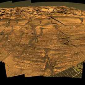
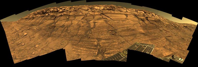
A view of “Burns Cliff” by Opportunity. Image credit: NASA/JPL/Cornell. Click to enlarge
Life may have had a tough time getting started in the ancient environment that left its mark in the Martian rock layers examined by NASA’s Opportunity rover. The most thorough analysis yet of the rover’s discoveries reveals the challenges life may have faced in the harsh Martian environment.

“This is the most significant set of papers our team has published,” said Dr. Steve Squyres of Cornell University, Ithaca, N.Y. He is principal investigator for the science instruments on Opportunity and its twin Mars Exploration Rover, Spirit. The lengthy reports reflect more thorough analysis of Opportunity’s findings than earlier papers.

Scientists have been able to deduce that conditions in the Meridiani Planum region of Mars were strongly acidic, oxidizing, and sometimes wet. Those conditions probably posed stiff challenges to the potential origin of Martian life.

Based on Opportunity’s data, nine papers by 60 researchers in volume 240, issue 1 of the journal Earth and Planetary Science Letters discuss what this part of the Martian Meridiani Planum region was like eons ago. The papers present comparisons to some harsh habitats on Earth and examine the ramifications for possible life on Mars.

Dr. Andrew Knoll of Harvard University, Cambridge, Mass., a co-author of the paper, said, “Life that had evolved in other places or earlier times on Mars, if any did, might adapt to Meridiani conditions, but the kind of chemical reactions we think were important to giving rise to life on Earth simply could not have happened at Meridiani.”

Scientists analyzed data about stacked sedimentary rock layers 23 feet thick, exposed inside “Endurance Crater.” They identified three divisions within the stack. The lowest, oldest portion had the signature of dry sand dunes; the middle portion had windblown sheets of sand. Particles in those two layers were produced in part by previous evaporation of liquid water. The upper portion, with some layers deposited by flowing water, corresponded to layers Opportunity found earlier inside a smaller crater near its landing site.

Materials in all three divisions were wet both before and after the layers were deposited by either wind or water. Researchers described chemical evidence that the sand grains deposited in the layers had been altered by water before the layers formed. Scientists analyzed how acidic water moving through the layers after they were in place caused changes such as the formation of hematite-rich spherules within the rocks.

Experimental and theoretical testing reinforces the interpretation of changes caused by acidic water interacting with the rock layers. “We made simulated Mars rocks in our laboratory, then infused acidic fluids through them,” said researcher Nicholas Tosca from the State University of New York, Stony Brook. “Our theoretical model shows the minerals predicted to form when those fluids evaporate bear a remarkable similarity to the minerals identified in the Meridiani outcrop.”

The stack of layers in Endurance Crater resulted from a changeable environment perhaps 3.5 to 4 billion years ago. The area may have looked like salt flats occasionally holding water, surrounded by dunes. The White Sands region in New Mexico bears a similar physical resemblance. For the chemistry and mineralogy of the environment, an acidic river basin named Rio Tinto, in Spain, provides useful similarities, said Dr. David Fernandez-Remolar of Spain’s Centro de Astrobiologia and co-authors.

Many types of microbes live in the Rio Tinto environment, one of the reasons for concluding that ancient Meridiani could have been habitable. However, the organisms at Rio Tinto are descended from populations that live in less acidic and stressful habitats. If Meridiani had any life, it might have had to originate in a different habitat.

“You need to be very careful when you are talking about the prospect for life on Mars,” Knoll said. “We’ve looked at only a very small parcel of Martian real estate. The geological record Opportunity has examined comes from a relatively short period out of Mars’ long history.”

NASA’s Jet Propulsion Laboratory, Pasadena, Calif., manages the Mars Exploration Rover project. Images and information about the rovers and their discoveries are available at http://www.nasa.gov/vision/universe/solarsystem/mer_main.html .

Original Source: NASA News Release

Spirit Wraps Up a Martian Year of Exploration

NASA’s Mars Exploration Rover Spirit. Image credit: NASA/JPL-Caltech. Click to enlarge
Spirit, the untiring robotic “wonder child” sent by NASA to explore the eerily earthlike fourth planet from the sun, has completed one martian year–that’s almost two Earth years–on Mars. Designed to last only 90 martian days (sols), the six-wheeled marvel the size of a golf cart has pursued a steady course of solar-driven geologic fieldwork, bringing back some 70,000 images and a new understanding of Mars as a potential habitat.

During Spirit’s martian year, the seasons have changed from summer to winter and back again. In its orbit around the Sun, Mars has returned to where it was when the rover first landed. Having survived seven times its expected lifetime and traveling over 3 miles (about 5,000 meters), Spirit is still going strong.

Hill Climbing with Spirit
“When we first took a look around after landing,” noted Cornell geologist and principal investigator Steve Squyres, “the ‘Columbia Hills’ seemed impossibly far away. Given its longer life, though, Spirit reached them and became the first explorer to climb a mountain on another planet. ‘Husband Hill’ is about as tall as the Statue of Liberty, but for a little rover, that was a heck of a climb.”

To achieve that feat, Spirit’s handlers painstakingly plotted a path up the slopes to keep the rover alive during the colder months of the martian year. A few months into the mission, winter was fast approaching and the Sun was ever lower above the northern horizon.

“We followed a circuitous path uphill, using the higher, uneven terrain to tilt the solar panels toward the Sun, keep the communications antenna facing Earth, and avoid rocks along the way,” said rover driver Chris Leger at NASA’s Jet Propulsion Laboratory.

While keeping warm in the winter, Spirit’s uphill battle also centered on what NASA sent both rovers to find: signs of past water on Mars. If water persisted for long periods of time in martian history, the red planet might have once had a life-supporting environment. At first, Spirit’s studies showed plenty of volcanic rocks, but few signs of minerals formed by water.

“Only by climbing did Spirit find what we were seeking,” said Ray Arvidson, deputy principal investigator from Washington University in St. Louis. “With Spirit’s engineering stamina, we finally found rocks in the ‘Columbia Hills’ that either formed in, or were altered by, water. Perhaps best of all, the hills hold the highest sulfur content ever found on Mars: sulfate salts, deposited by water.”

Besides finding these prized signs of past water on Mars, Spirit has discovered at least five distinct classes of rocks. Among these are molten rocks blasted upward and outward during meteorite impacts, materials formed during violent volcanic explosions, and lava flows. Beyond these large features, Spirit has taken a close look at grain-sized rock particles as well. “At a small scale, the geology of ‘Husband Hill’ looks like it’s been put in a blender,” said Squyres.

“All of this variety churned up in the rock record shows how volatile Mars was in the past,” Arvidson says. “Rocks in one layer say volcanoes were exploding, in another that lava was flowing, in another that water was seeping. And then imagine that some massive geologic force uplifted the whole of ‘Columbia Hills,’ exposing all of these layers to millions of years of wind erosion, gravity-driven landslides, and meteorite impacts.”

Seeing this rich geologic record on the north side of the Columbia Hills, Arvidson says, heightens the science team’s anticipation of what more they will learn about the history of the hills during Spirit’s trek down the other side.

Raising Spirit’s Energy
For Spirit’s continued journey, engineers are delighted with the unlikely role the martian wind has played in increasing the rover’s staying power. A peak threat of wind is the planet-encircling dust storms that can arise in martian spring through early summer, blocking out sunlight needed for power. “Luckily,” said project scientist Joy Crisp, “we haven’t yet seen a global dust storm since the rovers landed on Mars, but we have seen a lot of dust devils.”

Dust devils occur when the wind whirls over the surface, stirring dust up like a miniature tornado and traveling up to 13 feet per second (4 meters per second). It turns out the dust devils are primarily a lunchtime affair, mostly occurring between 11 a.m. and 3 p.m. at each rover site. For both rovers, these noontime winds have been very favorable.

While dozens of dust devils have passed before Spirit’s cameras, some have made contact, sweeping dust from the rover’s solar panels. The solar panels are then able to take in more sunlight and convert it into electricity, keeping Spirit “alive” for even longer.

Keeping Spirit Alive
While no one can predict how long Spirit will last, the rover’s stamina throughout the long martian year encourages hope. The science team is busy even now plotting new destinations to strive toward. If the “Columbia Hills” were once a distant dream, new far-off horizons beckon just as much. Getting there will stretch the rover’s capabilities as much as the imagination. Team member Jim Rice calls one such distant target, a rough and rugged terrain to the south, “the Promised Land.”

One thing is sure. No matter what the future holds, Spirit is already there.

Original Source: NASA News Release

Mars Reconnaissance Orbiter is Halfway to Mars

Artist’s concept of Mars Reconnaissance Orbiter. Image credit: NASA/JPL. Click to enlarge
NASA’s Mars Reconnaissance Orbiter successfully fired six engines for about 20 seconds today to adjust its flight path in advance of its March 10, 2006, arrival at the red planet.

Since its Aug. 12 launch, the multipurpose spacecraft has covered about 60 percent of the distance for its trip from Earth to Mars. It will fly about 40-million kilometers (25-million miles) farther before it enters orbit around Mars. It will spend half a year gradually adjusting the shape of its orbit, then begin its science phase. During that phase, it will return more data about Mars than all previous missions combined. The spacecraft has already set a record transmission rate for an interplanetary mission, successfully returning data at 6 megabits per second, fast enough to fill a CD-ROM every 16 minutes.

“Today’s maneuver mainly increases the speed to bring us to the target point at just the right moment,” said Tung-hanYou, chief of the Mars Reconnaissance Orbiter navigation team at NASA’s Jet Propulsion Laboratory, Pasadena, Calif. The intended nudge in velocity is 75 centimeters per second (less than 2 miles per hour). The spacecraft’s speed relative to the sun is about 27 kilometers per second (61,000 miles per hour).

Four opportunities for course adjustments were planned into the schedule before launch. Today’s, the second, used only the trajectory-correction engines. Each engine produces about 18 newtons (4 pounds) of thrust. The first course adjustment, on Aug. 27, doubled as a test of the six main engines, which produce nearly eight times as much thrust. Those main engines will have the big job of slowing the spacecraft enough to be captured into orbit when it reaches Mars. The next scheduled trajectory adjustment, on Feb. 1, 2006, and another one 10 days before arrival will be used, if necessary, for fine tuning, said JPL’s Allen Halsell, the mission’s deputy navigation chief.

The Mars Reconnaissance Orbiter mission will examine Mars in unprecedented detail from low orbit. Its instrument payload will study water distribution — including ice, vapor or liquid — as well as geologic features and minerals. The orbiter will also support future missions to Mars by examining potential landing sites and by providing a high-data-rate relay for communications back to Earth.

The mission is managed by JPL, a division of the California Institute of Technology, Pasadena, for the NASA Science Mission Directorate. Lockheed Martin Space Systems, Denver, is the prime contractor for the project and built the spacecraft.

For information about the Mars Reconnaissance Orbiter on the Web, visit http://www.nasa.gov/mro . For information about NASA and agency programs on the Web, visit http://www.nasa.gov/home/index.html .

Original Source: NASA News Release

Mars Express Radar Data is Coming In

Artist’s impression of MARSIS deployment complete. Image credit: ESA. Click to enlarge
The Mars Express radar, MARSIS, has now been deployed for more than four months. Here we report on the activities so far.

For the operational period up to now, Mars Express has been making its closest approaches to Mars predominantly in the daytime portion of its orbit. The MARSIS radar’s scientists are mainly collecting data about the upper layers of the Martian atmosphere, or “ionosphere”, which is the highly electrically conducting layer that is maintained by sunlight.

They are also continuing the laborious analysis of all data gathered during the first night-time observations last summer, especially in the search for and interpretation of possible signals from subsurface layers. This includes the search for a possible signature of underground water, in frozen or liquid state.

Radar science is a complex business – it is based on the detection of radio waves reflected by boundaries between different materials. By analysis of these “echoes”, it is possible to deduce information about the kind of material causing the reflection, such as estimates of its composition and physical state.

Different materials are characterised by their “dielectric constant”, that is the specific way they interact with electromagnetic radiation, such as radio waves. When a radio wave crosses the boundary of different layers of “material”, an echo is generated and carries a sort of “fingerprint” from the specific materials.

From the time delay for an echo to be received by the radar instrument, the distance or the depth of the layers of material producing the echo can be deduced.

While the Mars Express point closest approach is in daylight, MARSIS is only operating at higher frequencies within its capability because the lower-frequency radio signals get disturbed. With these higher frequencies, MARSIS can study the ionosphere and the surface, while some shallow subsurface sounding can still be attempted.

During night-time observations, like those performed briefly last summer immediately after deployment, it is possible for MARSIS to use all frequencies for scientific measurements, including the lowest ones, suitable for penetrating under the soil of Mars.

Tuning to different frequencies for different targets in different conditions is not the only secret of MARSIS. The instrument, responding to signals reflected from any direction, requires scientists also do a huge amount of analysis work to remove these interfering signals from the echoes.

A typical example of what they look for is “clutter backscattering”, which are reflections apparently coming from the subsurface, but actually produced by irregularities in the surface terrain that delay the return of the echo. For this “cleaning” work, the team also makes use of “surface echo simulator” computer programs.

In the first months of operations, MARSIS performed its first ionospheric sounding. The data are converted into typical plots, called “ionograms”, where the altitude at which the echo was generated, deduced by the echo time delay, is given for each transmitted frequency. The intensity of the various echo signals detected is indicated in different colours.

In parallel to the analysis of surface and subsurface signals, the scientists are studying all ionograms to draw the first conclusions on the nature and behaviour of the ionosphere of Mars, and of its interaction with the planet and the surrounding environment.

Original Source: ESA Portal

Spirit Sees a Martian Lunar Eclipse

Phobos. Image credit: NASA. Click to enlarge
NASA’s Mars Exploration Rover Spirit continues to take advantage of favorable solar power conditions to conduct occasional nighttime astronomical observations from the summit region of “Husband Hill.”

Spirit has been observing the martian moons Phobos and Deimos to learn more about their orbits and surface properties. This has included observing eclipses. On Earth, a solar eclipse occurs when the Moon’s orbit takes it exactly between the Sun and Earth, casting parts of Earth into shadow. A lunar eclipse occurs when the Earth is exactly between the Sun and the Moon, casting the Moon into shadow and often giving it a ghostly orange-reddish color. This color is created by sunlight reflected through Earth’s atmosphere into the shadowed region. The primary difference between terrestrial and martian eclipses is that Mars’ moons are too small to completely block the Sun from view during solar eclipses.

Recently, Spirit observed a “lunar” eclipse on Mars. Phobos, the larger of the two martian moons, was photographed while slipping into the shadow of Mars. Jim Bell, the astronomer in charge of the rover’s panoramic camera (Pancam), suggested calling it a “Phobal” eclipse rather than a lunar eclipse as a way of identifying which of the dozens of moons in our solar system was being cast into shadow.

With the help of the Jet Propulsion Laboratory’s navigation team, the Pancam team planned instructions to Spirit for acquiring the views shown here of Phobos as it entered into a lunar eclipse on the evening of the rover’s 639th martian day, or sol (Oct. 20, 2005) on Mars. This image is a time-lapse composite of eight Pancam images of Phobos moving across the martian sky. The entire eclipse lasted more than 26 minutes, but Spirit was able to observe only in the first 15 minutes. During the time closest to the shadow crossing, Spirit’s cameras were programmed to take images every 10 seconds.

In the first three images, Phobos was in sunlight, moving toward the upper right. After a 100-second delay while Spirit’s computer processed the first three images, the rover then took the fourth image, showing Phobos just starting to enter the darkness of the martian shadow. At that point, an observer sitting on Phobos and looking back toward the Sun would have seen a spectacular sunset! In the fifth image, Phobos appeared like a crescent, almost completely shrouded in darkness.

In the last three images, Phobos had slipped entirely into the shadow of Mars. However, as with our own Moon during lunar eclipses on Earth, it was not entirely dark. The small amount of light still visible from Phobos is a kind of “Mars-shine” — sunlight reflected through Mars’ atmosphere and into the shadowed region.

Rover scientists took some images later in the sequence to try to figure out if this “Mars-shine” made Phobos colorful while in eclipse, but they’ll need more time to complete the analysis because the signal levels are so low. Meanwhile, they will use the information on the timing of the eclipse to refine the orbital path of Phobos. The precise position of Phobos will be important to any future spacecraft taking detailed pictures of the moon or landing on its surface. In the near future it might be possible for one of the rovers to take images of a “Deimal” eclipse to learn more about Mars’ other enigmatic satellite, Deimos, as well.

Original Source: NASA News Release

Hubble Sees a Dust Storm on Mars

Mars photographed by Hubble. Image credit: Hubble. Click to enlarge.
NASA’s Hubble Space Telescope snapped this picture of Mars on October 28, within a day of its closest approach to Earth on the night of October 29. Hubble astronomers were also excited to have captured a regional dust storm on Mars that has been growing and evolving over the past few weeks.

The dust storm, which is nearly in the middle of the planet in this Hubble view is about 930 miles (1500 km) long measured diagonally, which is about the size of the states of Texas, Oklahoma, and New Mexico combined. No wonder amateur astronomers with even modest-sized telescopes have been able to keep an eye on this storm. The smallest resolvable features in the image (small craters and wind streaks) are the size of a large city, about 12 miles (20 km) across. The occurrence of the dust storm is in close proximity to the NASA Mars Exploration Rover Opportunity’s landing site in Sinus Meridiani. Dust in the atmosphere could block some of the sunlight needed to keep the rover operating at full power.

On October 29/30, Mars and Earth reached the point in their orbits where the two planets were the closest they have been since August of 2003. The red planet, named after the Roman god of war, won’t be this close again to Earth until 2018. At the 2005 closest approach Mars was at a distance of 43 million miles (69 million km), comparatively a stone’s throw across the solar system. Mars goes through a 26-month cycle where its distance from Earth changes. At times when the distance is smallest between the two planets, Mars appears brighter in the sky and larger through telescopes for Earth viewers.

This image of 2005 Mars closest approach was taken with Hubble’s Advanced Camera for Surveys. Different filters show blue, green, and red (250, 502 and 658 nanometer wavelengths). North is at the top of the image. Mars is now in its warmest months, closest to the Sun in its orbit, resulting in a smaller than normal south polar ice cap which has largely sublimated with the approaching summer.

The large regional dust storm appears as the brighter, redder cloudy region in the middle of the planet’s disk. This storm has been churning in the planet’s equatorial regions for several weeks now, and it is likely responsible for the reddish, dusty haze and other dust clouds seen across this hemisphere of the planet in views from Hubble, ground based telescopes, and the NASA and ESA spacecraft studying Mars from orbit. Bluish water-ice clouds can also be seen along the limbs and in the north (winter) polar region at the top of the image.

Original Source: Hubble News Release

Mars Express Instrument Working Again

Artist illustration of Mars Express. Image credit: ESA. Click to enlarge.
The Planetary Fourier Spectrometer (PFS) on board ESA’s Mars Express spacecraft is now back in operation after a malfunction, reported a few months ago.

The instrument had been successfully investigating the chemical composition of the Martian atmosphere since the beginning of 2004, when Mars Express began orbiting the Red Planet.

PFS is a very sensitive instrument, capable of measuring the distribution of the major gaseous components of the atmosphere, the vertical distribution of their temperature and pressure, and determining their variation and global circulation during the different Martian seasons.

PFS is also capable of detecting minor gaseous species and the presence of dust in the atmosphere and, during favourable observing conditions, even deducing the mineralogical composition of the soil.

PFS was the first instrument ever to make direct ‘in situ’ measurements of methane in the atmosphere of Mars, and provided first indications of traces of formaldehyde, both candidate ingredients for life.

To identify the nature of chemical compounds of the Martian atmosphere and their physical status, PFS detects the distinctive infrared radiation re-emitted by different molecules when they are exposed to the light of the Sun.

The complex PFS instrument uses the interferometry technique, a high-precision measurement method in which beams of electromagnetic radiation are split and subsequently recombined after travelling different path-lengths. The beams interfere and produce an ‘interference pattern’.

This pattern, or ‘interferogram’, is then used to measure physical properties such as temperature, pressure and chemical composition.

The PFS instrument was unable to produce scientific data from July to September 2005. A series of tests and investigations took place between September and October this year.

The ‘pendulum motor’, used to drive various elements in the instrument optics, was shown to be at fault. The recovery was made possible through using internal instrument redundancy.

After switching to the instrument’s back-up motor, more powerful than the first one – the instrument has been shown to be able to produce science data just as before. Following this recovery activity, PFS will start to take new measurements routinely in early November 2005.

Original Source: ESA News Release

Anything That Can Go Wrong, Will… on Mars

Mars. Image credit: NASA/JPL.
The spacecraft door has just clanged shut behind you, locking you and your fellow astronauts into the small cabin that will be your home for the next half-year’s journey through interplanetary space–at the end of which you personally will be the first human to set foot on Mars.

As the countdown echoes in your ears and as you feel the boosters rumbling beneath you, you wonder … Are we ready?

According to Murphy’s Law, whatever can go wrong, will go wrong, and presumably this applies on Mars as well as Earth. So if things go wrong on Mars, are we ready for them? What do we need to know about Mars before we send people there?

That question is what NASA’s Mars Exploration Program Analysis Group (MEPAG for short) addressed in its report dated June 2, 2005, which bears the long mouthful of a title An Analysis of the Precursor Measurements of Mars Needed to Reduce the Risk of the First Human Mission to Mars.

The heart of MEPAG’s June report is a full-page table on p. 11 that lists 20 risks, “any one of which could take out a mission,” says David Beaty, Mars Program Science Manager at the Jet Propulsion Laboratory, and the report’s lead author.

Top among those risks:
* Martian dust–its corrosiveness, its grittiness, its effect on electrical systems such as computer boards;
* possible Martian “replicating biohazards”–organisms dangerous either to the astronauts or for return to Earth;
* the dynamics of the Martian atmosphere, including dust storms, that might affect landing and takeoff;
* potential sources of water, especially crucial if the first astronauts were to stay on the surface longer than a month.

The group asked itself, “What would we need to learn by sending robotic missions to Mars to reduce each risk? And how much would that information lower the risk [e.g., if engineers could design the spacecraft differently to protect astronauts]?”

Loud and clear from the MEPAG report is that “Martian dust is a #1 risk,” says Jim Garvin, NASA chief scientist at the Goddard Space Flight Center. “We need to understand the dust in designing power systems, space suits and filtration systems. We need to mitigate it, keep it out, figure out how to live with it.”

According to MEPAG, a mission to gather and return samples of Martian soil and dust to Earth is crucial.

“Most scientists believe it’s not possible to evaluate biohazards without a sample return,” notes Beaty. In addition, a sample return could resolve controversies about just how gritty or how chemically toxic the Martian soil may be. Even though lunar dust proved to be a major problem for the Apollo astronauts, “lunar dust does not equal Martian dust,” Garvin cautions. Scientists and engineers simply need to get their hands on real Martian dirt. The significance of a sample even as small as 1 kilogram “should not be underestimated” for both its scientific and engineering value, Beaty adds.

The MEPAG report also gave high rank to measurements involving the release of probes with parachutes and balloons into the Martian atmosphere. “We could observe Martian wind speeds at different altitudes, which is vital both for targeting accuracy when a mission lands, and for reaching the right orbit when the mission departs,” Beaty says.

And then there’s water: MEPAG assigns high priority to robotic expeditions that could definitively find water, either as water ice or as deposits of hydrous minerals. Two versions of a first human expedition are being debated: a short stay of about a month, and a long stay of about a year and a half. While a short-stay mission might be able to carry all the water it needed with it–relying on closed-loop life-support systems to recycle waste-water–a long-stay mission would need to excavate fresh water and manufacture breathable oxygen from ice-filled Martian soils.

These are but a few of MEPAG’s recommendations. The full report may be read here.

MEPAG itself is something new.

“NASA is reinventing how it formally acquires advice,” explains Garvin. Until the last few years, NASA has relied either on commissioning formal recommendations from the National Academy of Sciences, or on constituting ad hoc working groups. But both “would go quiet” after completing a single report, so there was no mechanism for evaluating how such high-level recommendations translated into concrete specifications for engineering hardware, scientific experiments, and actual measurements.

In contrast, MEPAG is a permanent body of scientists and engineers, working rather like the former U.S. Congressional Office of Technology Assessment. Its sole purpose is to figure out how big-picture goals translate into specific design options for exploration.

“It’s worked so well that we’re seeking to use the MEPAG model to form similar groups devoted to analyzing mission approaches to the Moon, Venus, and the outer planets,” Garvin says.

Are we ready? Ask MEPAG.

Original Source: Science@NASA Story

Bright Mars This Weekend

Hubble image of Mars. Image credit: Hubble. Click to enlarge.
Look east in the next few evenings and you may see a big, reddish-yellow ‘star’, shining much brighter than any other. This is the planet Mars, and it is passing unusually close to Earth during late October and early November 2005.

Anyone should be able to see it, no matter how little you know about the stars or how badly light-polluted your sky may be.

During mid- to late October, Mars will be low in the east after sunset. Later in November evenings, Mars climbs higher into better view and shifts over to the south-east. Mars is at opposition (opposite the Sun in our sky) on 7 November. This means it rises at sunset, is up all night, and sets at sunrise.

Mars will be closest to Earth on the night of 29 October, passing by our planet at 69.4 million kilometres distance. However, Mars will look just about as big and brilliant for a couple of weeks before and after this date.

This is the nearest that Mars has come since its record-breaking close approach in August 2003 just after ESA’s Mars Express spacecraft was launched and sent to the Red Planet. At that time it passed by at a distance of only 55.8 million kilometres, the closest it had come in nearly 60 000 years.

In fact, not until summer 2018 will Mars again come as close to Earth as it is now. But this year, skywatchers at North American and European latitudes have a big advantage they did not have in 2003.

That year Mars was far south in the sky and never rose high enough for telescope users at mid-northern latitudes. But this time Mars is farther north and rises higher during the night, giving a sharper, cleaner view with a telescope through Earth’s blurring atmosphere.

Original Source: ESA News Release

Mars Once Had Plate Tectonics

Crustal magnetism readings across Mars. Image credit: NASA/JPL. Click to enlarge.
NASA scientists have discovered additional evidence that Mars once underwent plate tectonics, slow movement of the planet’s crust, like the present-day Earth. A new map of Mars’ magnetic field made by the Mars Global Surveyor spacecraft reveals a world whose history was shaped by great crustal plates being pulled apart or smashed together.

Scientists first found evidence of plate tectonics on Mars in 1999. Those initial observations, also done with the Mars Global Surveyor’s magnetometer, covered only one region in the Southern Hemisphere. The data was taken while the spacecraft performed an aerobraking maneuver, and so came from differing heights above the crust.

This high resolution magnetic field map, the first of its kind, covers the entire surface of Mars. The new map is based on four years of data taken in a constant orbit. Each region on the surface has been sampled many times. “The more measurements we obtain, the more accuracy, and spatial resolution, we achieve,” said Dr. Jack Connerney, co-investigator for the Mars Global Surveyor magnetic filed investigation at NASA’s Goddard Space Flight Center, Greenbelt, Md.

“This map lends support to and expands on the 1999 results,” said Dr. Norman Ness of the Bartol Research Institute at the University of Delaware, Newark. “Where the earlier data showed a “striping” of the magnetic field in one region, the new map finds striping elsewhere. More importantly, the new map shows evidence of features, transform faults, that are a “tell-tale” of plate tectonics on Earth.” Each stripe represents a magnetic field pointed in one direction­positive or negative­and the alternating stripes indicate a “flipping” of the direction of the magnetic field from one stripe to another.

Scientists see similar stripes in the crustal magnetic field on Earth. Stripes form whenever two plates are being pushed apart by molten rock coming up from the mantle, such as along the Mid-Atlantic Ridge. As the plate spreads and cools, it becomes magnetized in the direction of the Earth’s strong global field. Since Earth’s global field changes direction a few times every million years, on average, a flow that cools in one period will be magnetized in a different direction than a later flow. As the new crust is pushed out and away from the ridge, stripes of alternating magnetic fields aligned with the ridge axis develop. Transform faults, identified by “shifts” in the magnetic pattern, occur only in association with spreading centers.

To see this characteristic magnetic imprint on Mars indicates that it, too, had regions where new crust came up from the mantle and spread out across the surface. And when you have new crust coming up, you need old crust plunging back down­the exact mechanism for plate tectonics.

Connerney points out that plate tectonics provides a unifying framework to explain several Martian features. First, there is the magnetic pattern itself. Second, the Tharsis volcanoes lie along a straight line. These formations could have formed from the motion of a crustal plate over a fixed “hotspot” in the mantle below, just as the Hawaiian islands on Earth are thought to have formed. Third, the Valles Marineris, a large canyon six times as long as the Grand Canyon and eight times as deep, looks just like a rift formed on Earth by a plate being pulled apart. Even more, it is oriented just as one would expect from plate motions implied by the magnetic map.

“It’s certainly not an exhaustive geologic analysis,” said Dr. Mario Acuña, principal investigator for the Mars Global Surveyor magnetic filed investigation at Goddard Space Flight Center. “But plate tectonics does give us a consistent explanation of some of the most prominent features on Mars.”

Results were published in the Oct. 10 edition of the Proceedings of the National Academy of Science.

Other scientists working on the project included Dr. G. Kletetschka of the Catholic University of America, Washington, DC, and Goddard Space Flight Center; Dr. D.L. Mitchell and Dr. R.P. Lin of the University of California at Berkeley; and Dr. H. Reme of the Centre d’Etude Spatiale des Rayonnements in France. Dr. Acuña leads the international team that built and operates the Mars Global Surveyor magnetometers. The Jet Propulsion Laboratory, a division of the California Institute of Technology in Pasadena, manages the mission for NASA’s Science Mission Directorate in Washington.

Original Source: NASA News Release