Mars Will Be Closest on October 29/30

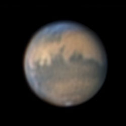
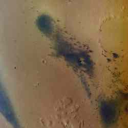
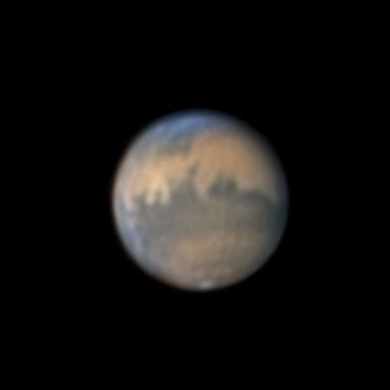
Mars on October 17?18, 2005, as recorded by Sky & Telescope assistant editor Sean Walker. Image credit: Sky and Telescope. Click to enlarge.
Look east late these evenings and you’ll see a big, fiery yellow “star” shining much brighter than any other. This is the planet Mars, and it’s passing unusually close to Earth during late October and early November 2005. Anyone can see it ? no matter how little you know about the stars or how badly light-polluted your sky may be.

During mid- to late October, look for Mars glaring low in the east after 8 p.m. local daylight-saving time. In November, it’s there in view as early as 6 p.m. standard time. Later in the evening, Mars climbs higher into better view and shifts over to the southeast. There’s nothing else nearly as bright that you can confuse it with.

Mars will be its closest to Earth on the night of October 29?30, passing 43.1 million miles (69.4 million kilometers) from our planet around 11:25 p.m. on the 29th Eastern Daylight Time. However, Mars will look just about as big and brilliant for a couple of weeks before and after that date.

Mars is at opposition (opposite the Sun in our sky) on November 7th. This means it rises at sunset, is up all night, and sets at sunrise.

This is the nearest that Mars has come since its record-breaking close approach in August 2003. At that time it passed by at a distance of only 34.7 million miles (55.8 million kilometers), the closest it had come in nearly 60,000 years. But for amateur telescope users, now is still a very special time. The planet will reach an apparent diameter of 20.2 arcseconds (the angular size of a penny seen at a distance of 620 feet), offering an usually detailed view of its surface. That compares with 25.1 arcseconds in August 2003 (the angular size of a penny at 500 feet), and only 15.9 arcseconds at Mars’s next swing-by, in December 2007 (a penny at 800 feet).

In fact, not until the summer of 2018 will Mars again come as close to Earth as it is right now (this statement remains true until mid-November).

Moreover, this year skywatchers at the latitudes of North America and Europe have a big advantage they didn’t have in 2003. That year Mars was far south in the sky and never got very high for telescope users at mid-northern latitudes. But this time Mars is farther north and rises higher during the night, affording a sharper, cleaner view in a telescope through Earth’s blurry atmosphere.

Telescope Tips
Good as this fall’s showing is, surface details on Mars are always a pretty tough target in a telescope. To begin with, Mars is only about half the size of Earth. Even at its closest, under high magnification it will appear as only a surprisingly small, bright ball with some subtle dark markings, possible white clouds around its edges, and perhaps a tiny remnant of the white South Polar Cap shrunken in the warmth of the Martian summer. The brightest yellow areas are deserts covered by fine, windblown dust. The darker markings are terrain displaying more areas of bare rock or darker sand and dust. Mars rotates every 24? hours, so you can see it turning in just an hour or two of watching.

To see much detail on Mars, several things all have to be working in your favor. You?ll need at least a moderately large telescope with high-quality optics. (For the lowdown on how to select a telescope wisely, see Sky & Telescope’s article “Choosing Your First Telescope”.) And you?ll need to wait until Mars rises high in the sky, well above the thick, murky layers of Earth’s atmosphere near the horizon. Moreover, the atmospheric “seeing” must be good. This is the astronomer?s term for the constant fuzzing and shimmering of highly magnified telescopic images due to the tiny heat waves that are always rippling through the atmosphere. The seeing changes from night to night and sometimes from moment to moment.

More about Mars and its unusual close approach appears in the September issue of Sky & Telescope and in the November/December 2005 issue of Night Sky, our new bimonthly magazine for beginners

Original Source: Sky and Telescope News Release

Mid-Latitude Glaciers on Mars

Viking image of Mars. Image credit: NASA/JPL. Click to enlarge.
New high-resolution images of mid-latitude Mars are revealing glacier-formed landscapes far from the Martian poles, says a leading Mars researcher.

Conspicuous trains of debris in valleys, arcs of debris on steep slopes and other features far from the polar ice caps bear striking similarities to glacial landscapes of Earth, says Brown University’s James Head III. When combined with the latest climate models and orbital calculation for Mars, the geological features make a compelling case for Mars having ongoing climate shifts that allow ice to leave the poles and accumulate at lower latitudes.

“The exciting thing is a real convergence of these things,” said Head, who will present the latest Mars climate discoveries on Sunday, 16 October, at the Annual Meeting of the Geological Society of America in Salt Lake City (specific time and location provided below).

“For decades people have been saying that deposits at mid and equatorial latitudes look like they are ice-created,” said Head. But without better images, elevation data and some way of explaining it, ice outside of Mars’ polar regions was a hard sell.

Now high-resolution images from the Mars Odyssey spacecraft’s Thermal Emission Imaging System combined with images from the Mars Global Surveyor spacecraft’s Mars Orbiter Camera and Mars Orbiter Laser Altimeter can be compared directly with glacier features in mountain and polar regions of Earth. The likenesses are hard to ignore.

For instance, consider what Head calls “lineated valley fill.” These are lines of debris on valley floors that run downhill and parallel to the valley walls, as if they mark some sort of past flow. The same sorts of lines of debris are seen in aerial images of Earth glaciers. The difference is that on Mars the water ice sublimes away (goes directly from solid ice to gas, without any liquid phase between) and leaves the debris lines intact. On Earth the lines of debris are usually washed away as a glacier melts.

The lines of debris on Mars continue down valleys and converges with other lines of debris – again, just like what’s seen on Earth where glaciers converge.

“There’s so much topography and the debris is so thick (on Mars) that it’s possible some of the ice might still be there,” said Head. The evidence for present day ice includes unusually degraded recent impact craters in these areas – just what you’d expect to see if a lot of the material ejected from the impact was ice that quickly sublimed away.

Another peculiarly glacier-like feature seen in Martian mid-latitudes are concentric arcs of debris breaking away from steep mountain alcoves – just as they do at the heads of glaciers on Earth.

As for how ice could reach Mars lower latitudes, orbital calculations indicate that Mars may slowly wobble on its spin axis far more than Earth does (the Moon minimizes Earth’s wobble). This means that as Mars’ axis tilted to the extremes – up to 60 degrees from the plane of Mars’ orbit – the Martian poles get a whole lot more sunshine in the summertime than they do now. That extra sun would likely sublime water from the polar ice caps, explains Head.

“When you do that you are mobilizing a lot of ice and redistributing it to the equator,” Head said. “The climate models are saying it’s possible.”

It’s pure chance that we happen to be exploring Mars when its axis is at a lesser, more Earth-like tilt. This has led to the false impression of Mars being a place that’s geologically and climatically dead. In fact, says Head, Mars is turning out to be a place that is constantly changing.

Original Source: Geological Society of America News Release

Ballooning on Mars

Artist illustration of a balloon floating above Mars. Image credit: ESA/Global Aerospace. Click to enlarge.
Mars rovers, Spirit and Opportunity, have, by now, spent almost two years on the surface of Mars. They traveled several miles each, frequently stopping and analyzing scientific targets with their cameras, spectrometers and other instruments to uncover evidence of liquid water on Mars in the past. Their mission is a smashing success for NASA.

But what if NASA had a platform on Mars that was able to cover these distances in a matter of hours instead and study the rocks on the surface in the same detail as rovers do? Scientific return from such a vehicle would be immense scientists would be able to study the whole planet in greater detail in a time span of a single year.

While orbiters can look at virtually any point on the surface of a planet, they lack the resolution provided by instruments on rovers or landers. Rovers, on the other hand, have limited mobility and cannot travel very far from their landing site. As the atmosphere of Mars is very thin, an airplane at Mars would last for just an hour until it runs out of fuel.

Global Aerospace Corporation of Altadena, CA proposes that the Mars exploration vehicle combining the global reach similar to that of orbiters and high resolution observations enabled by rovers could be a balloon that can be steered in the right direction and that would drop small science packages over the target sites. The concept being developed by the Global Aerospace Corporation is funded by the NASA Institute for Advanced Concepts (NIAC).

Balloons have been long recognized as unique, scientific platforms due to their relatively low cost and low power consumption. Two balloons flew in the atmosphere of Venus in 1984. In the past the inability to control the path of Mars balloons has limited their usefulness, and therefore scientific interest in their use.

Global Aerospace Corporation has designed an innovative device, called Balloon Guidance System (BGS) that enables steering a balloon through the atmosphere. The BGS is an aerodynamic surface a wing that hangs on a several kilometer-long tether below the balloon. The difference in winds at different altitudes create a relative wind at the latitude of the BGS wing, which in turn creates a lifting force. This lifting force is directed sideways and can be used to pull the balloon left or right relative to the prevailing winds.

Floating just several kilometers above the surface of Mars, the guided Mars balloons can observe rock formations, layerings in canyon walls and polar caps, and other features at very high resolution using relatively small cameras. They can be directed to fly over specific targets identified from orbital images and to deliver small surface laboratories, that will analyze the site at the level of detail rovers would do. Instruments at the balloon’s gondola can also measure traces of methane in the atmospheric and follow its increasing concentrations to the source on the ground. This way the search for existing or extinct life on Mars can be accelerated.

Original Source: NASA Astrobiology

Mars Express Mission Extended

Artist illustration of Mars Express. Image credit: ESA. Click to enlarge.
ESA?s Mars Express mission has been extended by one Martian year, or about 23 months, from the beginning of December 2005.

The decision, taken on 19 September by ESA?s Science Programme Committee, allows the spacecraft orbiting the Red Planet to continue building on the legacy of its own scientific success.

Co-ordinated from the beginning with the Mars science and exploration activities of other agencies, Mars Express has revealed an increasingly complex picture of Mars.

Since the start of science operations in early 2004, new aspects of Mars are emerging day by day, thanks to Mars Express data. These include its present-day climate system, and its geological ?activity? and diversity. Mars Express has also started mapping water in its various states.

In building up a global data set for composition and characteristics of the surface and atmosphere, Mars Express has revealed that volcanic and glacial processes are much more recent than expected.

It has confirmed the presence of glacial processes in the equatorial regions, and mapped water and carbon dioxide ice, either mixed or distinct, in the polar regions. Through mineralogical analysis, it found out that large bodies of water, such as lakes or seas, might not have existed for a long period of time on the Martian surface.

Mars Express has also detected methane in the Martian atmosphere. This, together with the possible detection of formaldehyde, suggests either current volcanic activity on Mars, or, more excitingly, that there are current active ?biological? processes.

This hypothesis may be reinforced by the fact that Mars Express saw that the distribution of water vapour and methane, both ingredients for life, substantially overlap in some regions of the planet.

Furthermore, the mission detected aurorae for the first time on the Red Planet. It has made global mapping of the density and pressure of the atmosphere between 10 and 100 kilometres altitude, and studied atmospheric escape processes in the upper layers of the atmosphere. This is contributing to our understanding of the weather and climate evolution of the planet.

There is still much to be discovered by the extraordinary set of instruments on board Mars Express. First, the 23-month extension will enable the Mars Express radar, MARSIS, to restart Martian night-time measurements in December this year.

MARSIS will continue its subsurface studies mainly in the search for liquid and frozen water. By combining subsurface, surface and atmospheric data, Mars Express will provide an unprecedented global picture of Mars and, in particular, its water.

So far, the High Resolution Stereo Camera has imaged only 19% of the Martian surface at high resolution. In the extended phase, it will be able to continue the 3D high-resolution colour imaging. After the Viking missions, Mars Express is building today?s legacy of Mars imagery for present and future generations of scientists.

Thanks to the extension, Mars Express will also be able to study for a second year the way the atmosphere varies during different seasons, and to observe again variable phenomena such as frost, fog or ice.

Finally, Mars Express will be able to revisit those areas where major discoveries, such as new volcanic structures, sedimentary layering, methane sources, nightglow and auroras, have been made, thus allowing to confirm and understand all aspects related to these discoveries.

Original Source: ESA News Release

Brand New Martian Gullies

Before (2002) and after pictures of a new gully on a sand dune on Mars. Image credit: NASA/JPL. Click to enlarge.
New gullies that did not exist in mid-2002 have appeared on a Martian sand dune.

That’s just one of the surprising discoveries that have resulted from the extended life of NASA’s Mars Global Surveyor, which this month began its ninth year in orbit around Mars. Boulders tumbling down a Martian slope left tracks that weren’t there two years ago. New impact craters formed since the 1970s suggest changes to age-estimating models. And for three Mars summers in a row, deposits of frozen carbon dioxide near Mars’ south pole have shrunk from the previous year’s size, suggesting a climate change in progress.

“Our prime mission ended in early 2001, but many of the most important findings have come since then, and even bigger ones might lie ahead,” said Tom Thorpe, project manager for Mars Global Surveyor at NASA’s Jet Propulsion Laboratory, Pasadena, Calif. The orbiter is healthy and may be able to continue studying Mars for five to 10 more years, he said.

Mars years are nearly twice as long as Earth years. The orbiter’s longevity has enabled monitoring of year-to-year patterns on Mars, such as seasonal dust storms and changes in the polar caps. “Mars is an active planet, and over a range of timescales changes occur, even in the surface,” said Dr. Michael Malin of Malin Space Science Systems, San Diego, principal investigator for the Mars Orbiter Camera on Mars Global Surveyor.

“To see new gullies and other changes in Mars surface features on a time span of a few years presents us with a more active, dynamic planet than many suspected before Mars Global Surveyor got there,” said Michael Meyer, Mars Exploration Program chief scientist, NASA Headquarters, Washington.

Two gullies appear in an April 2005 image of a sand-dune slope where they did not exist in July 2002. The Mars Orbiter Camera team has found many sites on Mars with fresh-looking gullies, and checked back at more than 100 gullied sites for possible changes between imaging dates, but this is the first such find. Some gullies, on slopes of large sand dunes, might have formed when frozen carbon dioxide, trapped by windblown sand during winter, vaporized rapidly in spring, releasing gas that made the sand flow as a gully-carving fluid.

At another site, more than a dozen boulders left tracks when they rolled down a hill sometime between the taking of images in November 2003 and December 2004. It is possible that they were set in motion by strong wind or by a “marsquake,” Malin said.

Some changes are slower than expected. Studies suggest new impact craters might appear at only about one-fifth the pace assumed previously, Malin said. That pace is important because crater counts are used to estimate the ages of Mars surfaces.

The camera has recorded seasonal patterns of clouds and dust within the atmosphere over the entire planet. In addition, other instruments on Mars Global Surveyor have provided information about atmospheric changes and year-to-year patterns on Mars as the mission has persisted. Daily mapping of dust abundance in Mars’ atmosphere by the Thermal Emission Spectrometer has shown dust over large areas during three Mars southern hemisphere summers in a row. However, the extent and duration of dust storms varied from year to year.

Mars Global Surveyor was launched Nov. 7, 1996; entered orbit around Mars Sept. 12, 1997; and returned the first Mars data from its science instruments Sept. 15, 1997. Beyond its own investigations, the orbiter provides support for other Mars missions, such as landing-site evaluations, atmospheric monitoring, communication relay and imaging of hardware on the surface. JPL, a division of the California Institute of Technology in Pasadena, manages the mission for NASA’s Science Mission Directorate, Washington. JPL’s industrial partner is Lockheed Martin Space Systems, Denver, which built and operates the spacecraft.

For newly released images on the Internet, visit: http://www.nasa.gov/vision/universe/solarsystem/mgs-092005-images.html and http://www.msss.com/mars_images/moc/2005/09/20/ .

Original Source: NASA/JPL News Release

Mars Reconnaissance Orbiter is Doing Well

Artist’s concept of Mars Reconnaissance Orbiter. Image credit: NASA/JPL Click to enlarge
Three cameras on NASA’s Mars Reconnaissance Orbiter worked as expected in a test pointing them at the moon and stars on Sept. 8.

“We feel great about how the camera performed and can hardly wait to see what it will show us at Mars,” said Dr. Alfred McEwen of the University of Arizona, Tucson, principal investigator for the High Resolution Imaging Science Experiment aboard Mars Reconnaissance Orbiter.

The test also checked operation of the spacecraft’s Context Camera and Optical Navigation Camera, plus the spacecraft’s high-gain antenna and systems for handling and distributing data from the instruments.

“The instruments and the ground data system passed this test with flying colors,” said Mars Reconnaissance Orbiter Project Manager Jim Graf of NASA’s Jet Propulsion Laboratory, Pasadena, Calif. “We received 75 gigabits of data in less than 24 hours, which is a new one-day record for any interplanetary mission.”

The spacecraft was about 10 million kilometers (6 million miles) from the moon when it turned to slew the cameras’ fields of view across that test target. At that distance, the moon would appear as a single star-like dot to the unaided eye. In the test images by the high-resolution camera, it is about 340 pixels in diameter and appears as a crescent about 60 pixels wide. The tests also included imaging of the star cluster Omega Centauri for data to use in calibrating the camera.

During its primary science mission at Mars, the spacecraft will orbit within about 300 kilometers (186 miles) of that planet’s surface. From that distance, the high-resolution camera will discern objects as small as one meter or yard across.

The Mars Reconnaissance Orbiter, launched on Aug. 12, will reach Mars and enter orbit on about March 10, 2006. After gradually adjusting the shape of its orbit for half a year, it will begin its primary science phase in November 2006. The mission will examine Mars in unprecedented detail from low orbit, returning several times more data than all previous Mars missions combined. Scientists will use its instruments to gain a better understanding of the history and current distribution of Mars’ water. By inspecting possible landing sites and by providing a high-data-rate relay, it will also support future missions that land on Mars.

More information about the mission, including new test images of the moon by the high-resolution camera, is available online at http://www.nasa.gov/mro.

The Mars Reconnaissance Orbiter mission is managed by JPL, a division of the California Institute of Technology, Pasadena, for the NASA Science Mission Directorate. Lockheed Martin Space Systems, Denver, prime contractor for the project, built both the spacecraft and the launch vehicle. Ball Aerospace & Technologies Corp., Boulder, Colo., built the High Resolution Imaging Science Experiment instrument for the University of Arizona to provide to the mission. Malin Space Science Systems, San Diego, Calif., provided the Context Camera. JPL provided the Optical Navigation Camera.

Original Source: NASA News Release

Investigation Into One of Mars Express’ Instruments

Artist’s impression of Mars Express. Image credit: ESA Click to enlarge
ESA has started a technical investigation into the Planetary Fourier Spectrometer (PFS) on board Mars Express, after a problem developed in the instrument a few months ago.

Vibration effects (induced by spacecraft activities) have been suggested as a cause for the observed behaviour. However no source has yet been identified and other causes internal to the instrument cannot be fully ruled out.
In order to establish the exact cause of the problem, ESA?s Mars Express team is setting up an investigations board involving experts from the Mission Science Working Team, ESA, industry and the Italian Space Agency (ASI).

This could lead to resuming scientific observations using modified procedures but, until all existing data and a number of additional measurements currently being planned have been examined, it is too early to draw a conclusion on the operational status of the PFS instrument.

The PFS instrument has performed without any such problems for almost two years, following the launch of Mars Express in June 2003. In this period, the instrument has provided much new information on the global composition and movement of the Martian atmosphere.

Even if it is found that PFS is no longer fully functional, it is only one element in the scientific package on board Mars Express. The other six instruments (HRSC, OMEGA, ASPERA, SPICAM, MARSIS, MaRS) are all currently working well and are providing new insights into the Red Planet and its evolution. These remaining instruments will continue the scientific success of the Mars Express mission.

Original Source: ESA Portal

Water detection at Gusev crater described

Color picture of Gusev crater. Image credit: ESA Click to enlarge
A large team of NASA scientists, led by earth and planetary scientists at Washington University in St. Louis details the first solid set of evidence for water having existed on Mars at the Gusev crater, exploration site of the rover Spirit.

Using an array of sophisticated equipment on Spirit, Alian Wang, Ph.D., Washington University senior research scientist in earth and planetary sciences in Arts & Sciences, and the late Larry A. Haskin, Ph.D., Ralph E. Morrow Distinguished University Professor of earth and planetary sciences, found that the volcanic rocks at Gusev crater near Spirit’s landing site were much like the olivine-rich basaltic rocks on Earth, and some of them possessed a coating rich in sulfur, bromine, chlorine and hematite, or oxidized iron. The team examined three rocks and found their most compelling evidence in a rock named Mazatzal.

The rock evidence indicates a scenario where water froze and melted at some point in Martian history, dissolving the sulfur, chlorine and bromine elements in the soil. The small amount of acidic fluids then react with the rocks buried in the soil and formed these highly oxidized coatings.

Trench-digging rover

During its traverse from landing site to Columbia Hills, the rover Spirit dug three trenches, allowing researchers to detect relatively high levels of magnesium sulfate comprising more than 20 percent of the regolith ? soil containing pieces of small rocks ? within one of the trenches, the Boroughs trench. The tight correlation between magnesium and sulfur indicates an open hydrologic system ? these ions had been carried by water to this site and deposited.

Spirit’s fellow rover Opportunity earlier had detected a history of water at another site on Mars, Meridiani planum. This study (by Haskin et al.) covered the investigation of Spirit rover sols (a sol is a Martian day) 1 through 156, with the major discoveries occurring after sol 80. After the findings were confirmed, Spirit traversed to the Columbian hills, where it found more evidence indicating water. The science team is currently planning for sol 551 operation of Spirit rover, which is only 55 meters away from the summit of Columbia Hills.

Spirit was on sol 597 on Sept 6 and on the summit of Husband Hill.

“We will stay on the summit for a few weeks to finish our desired investigations, then go downhill to explore the south inner basin, especially the so-called ‘home-plate,’ which could be a feature of older rock or a filled-in crater,” Wang said. “We will name a major geo-feature in the basin after Larry.”

Buried again and again

“We looked closely at the multiple layers on top of the rock Mazatzal because it had a very different geochemistry and mineralogy,” said Wang. “This told us that the rock had been buried in the soil and exposed and then buried again several times over the history. There are chemical changes during the burial times and those changes show that the soil had been involved with water.

“The telltale thing was a higher proportion of hematite in the coatings. We hadn’t seen that in any previous Gusev rocks. Also, we saw very high chlorine in the coating and very high bromine levels inside the rock. The separation of the sulfur and chlorine tells us that the deposition of chlorine is affected by water.”

While the multilayer coatings on rock Mazatzal indicates a temporal occurrence of low quantity water associated with freezing and melting of water, the sulfate deposition at trench sites indicates the involvement of a large body of water.

“We examined the regolith at different depths within the Big Hole and the Boroughs trenches and saw an extremely tight correlation between magnesium and sulfur, which was not observed previously,” Wang said. “This tells us that magnesium sulfate formed in these trench regoliths. The increasing bromine concentration and the separation of chlorine from sulfur also suggests the action of water. We don’t know exactly how much water is combined with that. The fact that the magnesium sulfate is more than 20 percent of the examined regolith sample says that the magnesium and sulfur were carried by water to this area from another place, and then deposited as magnesium sulfate. A certain amount of water would be needed to accomplish that action.”

Original Source: WUSTL News Release

Biblis Patera Volcano

Biblis Patera. Image credit: ESA Click to enlarge
This image, taken by the High Resolution Stereo Camera (HRSC) on board ESA?s Mars Express spacecraft, shows the Biblis Patera volcano, located in the western part of the Tharsis rise on Mars.

The HRSC obtained this image during orbit 1034 with a ground resolution of approximately 10.8 metres per pixel. The scene shows the region of Biblis Patera, at approximately 2.0? North and 236.0? East.

Located between Olympus Mons and Tharsis Montes, the volcano Biblis Patera is 170 kilometres long, 100 kilometres wide and rises nearly three kilometres above its surroundings.

The bowl-shaped depression (the ?caldera?) may have been formed as the result of collapse of the magma chamber during eruptions of the volcano. The caldera has a diameter of 53 kilometres and extends to a maximum depth of roughly 4.5 kilometres.

The morphology of the caldera suggests that multiple collapse events have occurred.The radial depressions and faint concentric circles on the flanks of the volcano are most likely faults associated with the formation of Biblis Patera.

In the south-west (top left), the linear features extending north-west to south-east appear to be faults. Surrounding Biblis Patera there are more faults with a similar orientation and which may be related to the formation of the Tharsis Rise.

Biblis Patera is older than the surrounding plains, which consist of lava flows originating from Pavonis Mons (the middle one of the Tharsis Montes volcanoes). In the main colour image, clouds obscure the surface to the north-east of the caldera (bottom right), making it appear grey and less reddish-orange in colour.

The stereo and colour capability and the high-resolution coverage of extended areas with the HRSC allow the improved study of the complex geological evolution of the Red Planet.

By supplying new image data for volcanoes like Biblis Patera, the HRSC provides scientists with the opportunity to better understand the morphology and volcanic history of Mars.

Data from the HRSC, coupled with information from other instruments on Mars Express and other missions, improves our understanding of this fascinating planet.

Original Source: ESA Mars Express

Spirit’s Mountaintop View

Mini-panorama taken by Spirit. Image credit: NASA/JPL Click to enlarge
Working atop a range of Martian hills, NASA’s Spirit rover is rewarding researchers with tempting scenes filled with evidence of past planet environments.

“When the images came down and we could see horizon all the way around, that was every bit as exhilarating as getting to the top of any mountain I’ve climbed on Earth,” said Chris Leger, a rover planner at NASA’s Jet Propulsion Laboratory, Pasadena, Calif.

The summit sits 82 meters (269 feet) above the edge of the surrounding plains. It is 106 meters (348 feet) higher than the site where Spirit landed nearly 20 months ago. Spirit and twin rover, Opportunity, successfully completed their three-month prime missions in April 2004. They have inspected dozens of rocks and soil targets since then, continuing their pursuit of geological evidence about formerly wet conditions on Mars.

“Spirit has climbed to the hilltop and looked over the other side, but NASA did not do this just to say we can do it. The Mars rovers are addressing fundamental questions about Martian history and planetary environments,” said NASA’s Mars Exploration Program Director Doug McCuistion.

The crest of “Husband Hill” offers Spirit’s views of possible routes into a basin to the south with apparently layered outcrops. Shortly after Spirit landed, it observed a cluster of seven hills about 3 kilometers (2 miles) east of its landing site. NASA proposed naming the range “Columbia Hills” in tribute to the last crew of Space Shuttle Columbia. The tallest of the hills commemorates Rick Husband, Columbia’s commander.

Volcanic rocks covering the plain Spirit crossed on its way to the hills bore evidence of only slight alteration by water. When Spirit reached the base of the hills five months after landing, it immediately began finding rocks with wetter histories.

“This climb was motivated by science,” said Steve Squyres of Cornell University, Ithaca, N.Y. Squyres is principal investigator for the rovers’ science instruments. “Every time Spirit has gained altitude, we’ve found different rock types. Also, we’re doing what any field geologist would do in an area like this: climbing to a good vantage point for plotting a route.”

Researchers are viewing possible routes south to apparently layered ledges and to a feature dubbed “home plate,” which might be a plateau of older rock or a filled-in crater.

The landing site and the Columbia Hills are within Gusev Crater, a bowl about 150 kilometers (95 miles) in diameter. The crater was selected as the landing site for the Spirit rover because the shape of the terrain suggests the crater once held a lake. Volcanic deposits appear to have covered any sign of ancient lakebed geology out on the plain, but scientists say the hills expose older layers that have been lifted and tipped by a meteorite impact or other event.

“We’re finding abundant evidence for alteration of rocks in a water environment,” said Ray Arvidson of Washington University, St. Louis, Mo. Arvidson is deputy principal investigator for the rovers’ science instruments. “What we want to do is figure out which layers were on top of which other layers. To do that it has been helpful to keep climbing for good views of how the layers are tilted to varying degrees. Understanding the sequence of layers is equivalent to having a deep drill core from drilling beneath the plains.”

Both Spirit and Opportunity have been extremely successful. Their solar panels are generating plenty of energy thanks to repeated dust-cleaning events. Spirit has driven 4,827 meters (3.00 miles), and Opportunity 5,737 meters (3.56 miles).

JPL manages the Mars Exploration Rover project for NASA’s Science Mission Directorate. For images and information about the rovers and their discoveries on the Web, visit: http://www.nasa.gov/vision/universe/solarsystem/mer_main.html or http://marsrovers.jpl.nasa.gov.

Original Source: NASA News Release