Juventae Chasma on Mars

The depression of Juventae Chasma taken by HRSC. Image credit: ESA Click to enlarge
These images, taken by the High Resolution Stereo Camera (HRSC) on board ESA’s Mars Express spacecraft, show the depression of Juventae Chasma, cut into the plains of Lunae Planum on Mars.

The HRSC obtained these images during orbit 243 with a ground resolution of approximately 23.4 metres per pixel. The scenes show the region of Lunae Planum, at approximately 5? South and 297? East.

The depression of Juventae Chasma, located north of Valles Marineris, cuts more than 5000 metres into the plains of Lunae Planum. The floor of Juventae Chasma is partly covered by dunes.

In the valley, to the north-east, there is a mountain composed of bright, layered material. This mountain is approximately 2500 metres high, it has a length of 59 kilometres and a width of up to 23 kilometres.

The OMEGA spectrometer on board Mars Express will be able to confirm that this mountain is indeed composed of sulphate deposits. The colour scenes have been derived from the three HRSC-colour channels and the nadir channel.

***image4:left***The perspective views have been calculated from the digital terrain model derived from the stereo channels. The 3D anaglyph image was calculated from the nadir and one stereo channel. Image resolution has been decreased for use on the internet.

Original Source: ESA Mars Express

When a Meteor Slashed Mars

Color view of ‘butterfly’-shaped crater at Hesperia Planum. Image credit: ESA Click to enlarge
These images, taken by the High Resolution Stereo Camera (HRSC) on board ESA?s Mars Express spacecraft, show a large elliptical impact crater in the Hesperia Planum region of Mars.

The HRSC obtained these images during orbit 368 with a ground resolution of approximately 16.7 metres per pixel. The scenes show the region of Hesperia Planum, at approximately 35.3? South and 118.7? East. A large elliptical impact crater is visible within the scene, measuring approximately 24.4 km long, 11.2 km wide and reaching a maximum depth of approximately 650 metres below the surrounding plains.

Ejecta from this impact can be seen extending away from the crater, including two prominent lobes of material north-west and south-east of the crater.

The large circular feature, partly cut off by the border of the image, has a diameter of roughly 45 km.

This appears to be an impact crater that was subsequently resurfaced by lava flows, preserving the outline of the underlying crater. The curving features visible in the north of the image, known as ?wrinkle ridges?, are caused by compressional tectonics.

While the majority of impact craters are relatively circular, the elliptical shape of this impact crater suggests a very low impact angle (less than 10 degrees).

The long axis of the impact crater is viewed as the impacting direction of the projectile. Similar elliptical craters are observed elsewhere on Mars, as well as on our Moon.

The colour scenes have been derived from the three HRSC-colour channels and the nadir channel. The perspective views have been calculated from the digital terrain model derived from the stereo channels.

Color view of ‘butterfly’-shaped crater at Hesperia Planum. Image credit: ESA Click to enlarge

The 3D anaglyph image was calculated from the nadir and one stereo channel. Image resolution has been decreased for use on the internet.

Original Source: ESA Mars Express

Lakebed on Mars Wasn’t So Watery In the Past

Mars seems not to be as wet as it was predicted. Image credit: NASA Click to enlarge
A region of Mars that some planetary scientists believe was once a shallow lakebed and likely habitable for life may not have been so wet after all, according to a new University of Colorado at Boulder study.

The new study indicates chemical signatures in the bedrock, interpreted in 2004 by the Mars Exploration Rover, or MER, mission team as evidence for widespread, intermittent water at Mars’ surface, may have instead been created by the reaction of sulfur-bearing steam vapors moving up through volcanic ash deposits. Known as Meridiani Planum, the region may have been more geologically similar to volcanic regions in parts of North America, Hawaii or Europe, said Thomas McCollom of CU-Boulder’s Center for Astrobiology.

“Our study indicates it was probably more like parts of Yellowstone, Hawaii or Italy than something like the Great Salt Lake,” said McCollom, also a research associate at CU-Boulder’s Laboratory for Atmospheric and Space Physics. “We think it was far less favorable for past biological activity than other scenarios that have been proposed.”

A paper on the subject by McCollom and CU-Boulder Research Associate Brian Hynek of CU-Boulder’s LASP appears in the Dec. 22 issue of Nature.

A series of scientific papers published in December 2004 by the Mars Exploration Rover team and based on data gathered by the rover Opportunity, concluded that the Meridiani Planum region once probably had a large sea or huge lake that may have waxed and waned over eons. The authors proposed that the evaporation of surface and subsurface water over time left behind various chemical precipitates — predominately sulfate salts — which they interpreted as evidence for a watery environment that would have been conducive for life to exist.

But if the sulfate was the result of precipitation from an evaporating brine of surface and subsurface water as has been proposed, McCollom and Hynek contend the bedrock should be enriched with a large amount of positively charged atoms, known as cations, from minerals like iron, calcium and magnesium. But it is not, they said.

“We think the bedrock was laid down by enormous volcanic ash flows over time that were then permeated by sulfur dioxide-rich steam vapors,” said McCollom. “The sulfur dioxide and water combined to form sulfuric acid, which reacted with and altered the bedrock to give it its present chemical composition.”

The new scenario does not require prolonged interaction between bedrock and a standing body of surface water as proposed by the MER team, and the process likely occurred at high temperatures, perhaps more than 200 degrees F, said McCollom. “Everything about the site seems to be consistent with our conclusions,” he said.

“In our scenario, the water required to support the chemistry in this bedrock would only have had to have been around for months, years or perhaps as much as a few centuries,” said Hynek. “This is very different than previous scenarios, which require that a much larger amount of water be present for many millennia.”‘

The European Space Agency’s Mars Express spacecraft recently showed the chemistry of layered deposits surrounding the Meridiani Planum region is similar to the bedrock at the Opportunity landing site, implying the entire area hosted volcanic activity, said Hynek. The size of the suspected Meridiani Planum volcanic deposits appears much larger than any similar deposit on Earth and encompasses an area roughly the size of Arizona, according to the CU-Boulder researchers.

McCollom described the geology of the region as “solfatara-like,”‘ a term that originated from Solfatara Crater, a volcanic region near Naples, Italy, harboring vents that emit vapors. “While solfataras are riddled with vents and fissures giving off sulfurous vapors at the surface, the deposits we see at Meridiani probably represent the subsurface beneath such fissures,” said McCollom.

On Earth, solfataras host microbes that are capable of using sulfur for sustenance, McCollom said. Some of the areas are now under study by astrobiologists looking to characterize extreme environments on Earth that support life.

“My view is that there is a good possibility there is life on Mars, probably in the subsurface,” he said. “We know from examples on Earth that life can exist in extreme places, and Mars seems to have the necessary ingredients for that.”

Hynek said that in the distant past, Meridiani Planum may have had all the necessary ingredients to support organisms like those found in solfataras. “But the unique and probably short-lived nature of the environment suggests it may not be the best place to look for evidence of Martian life today,” he said.

Original Source: CU-Boulder News Release

Has Beagle 2 Been Found?

Artist’s impression of Beagle 2 lander. Image credit: ESA Click to enlarge
The news that Beagle 2 may have been spotted on the surface of Mars in the immediate vicinity of where it was expected to land was welcomed by the European Space Agency.

ESA?s Mars Express spacecraft had delivered the Beagle 2 lander to Mars on 25 December 2003.

ESA?s Director of Science David Southwood said, “If this turns out to be a definitive sighting then we can feel very pleased not only for the Beagle 2 team but also for everyone else involved in getting the probe to Mars and accurately into its descent.”

“Although the discovery cannot make up for the loss of science, there can be more confidence that Beagle 2 made it down to the surface. The search itself has been not been easy and it says something for the persistence and dedication of the team that this report has emerged.”

It is also important if the scenario of impact, as outlined by the team on the basis of the NASA Mars Global Surveyor spacecraft images, can be further investigated.

“This information, if consolidated, can limit what might have gone wrong two years ago and we can use it to increase our own confidence and faith in the methods used when we next face the challenge of going to Mars,” added Southwood.

ESA received the go-ahead for a new European lander mission to Mars, Exomars, with the subscription by Member States for a new exploration programme, Aurora, just a few weeks ago at the ESA Council of Ministers in Berlin on 5-6 December 2005.

Original Source: ESA Portal

Mission to Mars via Antarctica

Concordia Station in Antarctica. Image credit: IPEV Click to enlarge
A few weeks before leaving for the Antarctic Concordia Station, the Italian-French crew that will spend over one year in one of the harshest, isolated environments on Earth, attended two days of preparatory training at ESA’s Headquarters in Paris, France. During their stay at the research station the crew will participate in a number of ESA experiments ? the outcome of which will help prepare for long-term missions to Mars.

As part of the Aurora Exploration Programme, ESA is considering participating in a human mission to Mars by the year 2030. Research projects are planned or are already underway to develop the technology and knowledge needed. By being involved in programmes that have requirements similar to those of a mission to Mars, ESA will gain experience on how best to prepare for such a challenging mission.

“The Concordia Station is an ideal location as it replicates certain aspects of a Mars mission,” explains Oliver Angerer, ESA’s coordinator for the Concordia research programme. “The crew lives in an extreme environment in one of the most remote places on Earth. During the winter the base is completely cut off with no visitors and no chance for rescue. In such an isolated location, the crew has to learn to be fully self-sufficient.”

Cooperation

Built and operated jointly by the French Polar Institute (Institute Paul Emile Victor, IPEV) and the Italian Antarctic Programme (Consorzio per l?attuazione del Programma Nazionale di Richerche in Antartide, PNRA S.C.r.l.), the Concordia Station was completed in 2004. A letter of intent was signed with IPEV and PNRA in 2002 that enabled ESA to cooperate on some aspects of the project.

Capable of providing home to up to 16 crewmembers in the winter, the station consists of three buildings, which are interlinked by enclosed walkways. Two large cylindrical three-storey buildings provide the station’s main living and working quarters, whilst the third building houses technical equipment, like the electrical power plant and boiler room.

Last November, the first crew finished their winter-over which was dedicated to the technical qualification of the station . The summer season sees a swelling in the number of inhabitants as short-stay scientists take advantage of the less extreme weather (however, mean air temperature is about -30?C during this time!). With the second crew now starting to gather at the remote research station, the summer season also marks a change over of the crew.

Briefings

Three scientists who are part of the next Concordia winter-over crew have already made the long journey to Antarctica. The rest of the crew, who will leave for the Antarctic research station during December, gathered at ESA’s Headquarters in Paris for two days of pre-departure training. They received briefings about life at Concordia, including aspects such as safety and the implications of the Antarctic Treaty for activities at the station.

The seven crewmembers also heard about research at the station, including two special experiments for which they will act as subjects during their stay. In 2003, ESA coordinated together with the Concordia partners a Research Announcement for medical and psychological research, from which six proposals were selected.

The two experiments, which are the first to be implemented in the coming season, look at psychological adaptation to the environment and the process of developing group identity; issues that will also be important factors for humans travelling to Mars. For this research the crew will complete questionnaires at regular intervals throughout their stay.

ESA’s Mistacoba experiment, which already started a year ago when the first crew started living at the station, will also continue after the crew rotation. Starting from a newly built clean environment, samples are taken from fixed locations in the base as well as from crewmembers themselves. The Mistacoba experiment will provide a profile of how microbes spread and evolve in the station – an isolated and confined environment – over time.

Water-recycling

To protect the Antarctic environment, all waste materials must be removed from the Continent. For the Concordia Station, this means that all waste materials have to be appropriately treated. Regarding water, based on ESA life support technologies, ESA developed, together with PNRA and IPEV, a system to recycle the so-called ‘grey water’ collected from showers, laundry and dishwashing, which has been operating for a year in line with the requirements of the Concordia partners.

Other ESA activities for Concordia include the ongoing development of a system to monitor the health and well being of the crew, part of the Long Term Medical Survey (LMTS). Physiological parameters, collected using a vest-like item of clothing, will provide valuable data about the health and fitness of crew during long-term stays in harsh environments.

Real environment

In mid-February the last plane of summer visitors will depart from Concordia leaving the crew to their own devices. “For those nine winter months the crew will experience extreme isolation,” adds Oliver Angerer. “Concordia is a real operational environment, something we would never be able to simulate in a laboratory. This will enhance and complement our research and give us valuable insight we need to prepare for Mars.”

Original Source: ESA Portal

Martian Bacteria Could Be Under the Ice

Martian surface. Image credit: NASA Click to enlarge
A University of California, Berkeley, study of methane-producing bacteria frozen at the bottom of Greenland’s two-mile thick ice sheet could help guide scientists searching for similar bacterial life on Mars.

Methane is a greenhouse gas present in the atmospheres of both Earth and Mars. If a class of ancient microbes called Archaea are the source of Mars’ methane, as some scientists have proposed, then unmanned probes to the Martian surface should look for them at depths where the temperature is about 10 degrees Celsius (18 degrees Fahrenheit) warmer than that found at the base of the Greenland ice sheet, according to UC Berkeley lead researcher P. Buford Price, a professor of physics.

This would be several hundred meters – some 1,000 feet – underground, where the temperature is slightly warmer than freezing and such microbes should average about one every cubic centimeter, or about 16 per cubic inch.

While Price is not expecting any time soon a mission to Mars to drill several hundred meters beneath the surface, methanogens (methane-generating Archaea) could just as easily be detected around meteor craters where rock has been thrown up from deep underground.

“Detecting this concentration of microbes is within the ability of state-of-the-art instruments, if they could be flown to Mars and if the lander could drop down at a place where Mars orbiters have found the methane concentration highest,” Price said. “There are oodles of craters on Mars from meteorites and small asteroids colliding with Mars and churning up material from a suitable depth, so if you looked around the rim of a crater and scooped up some dirt, you might find them if you land where the methane oozing out of the interior is highest.”

Price and his colleagues published their findings last week in the Early Online edition of the journal Proceedings of the National Academy of Sciences, and presented their results at last week’s meeting of the American Geophysical Union in San Francisco.

Variations in methane concentration in ice cores, such as the 3,053-meter-long (10,016-foot-long) core obtained by the Greenland Ice Sheet Project 2, have been used to gauge past climate. In that core, however, some segments within about 100 meters, or 300 feet, of the bottom registered levels of methane as much as 10 times higher than would be expected from trends over the past 110,000 years.

Price and his colleagues showed in their paper that these anomalous peaks can be explained by the presence in the ice of methanogens. Methanogens are common on Earth in places devoid of oxygen, such as in the rumens of cows, and could easily have been scraped up by ice flowing over the swampy subglacial soil and incorporated into some of the bottom layers of ice.

Price and his colleagues found these methanogens in the same foot-thick segments of the core where the excess methane was measured in otherwise clear ice at depths 17, 35 and 100 meters (56, 115 and 328 feet) above bedrock. They calculated that the measured amount of Archaea, frozen and barely active, could have produced the observed amount of excess methane in the ice.

“We found methanogens at precisely those depths where excess methane had been found, and nowhere else,” Price said. “I think everyone would agree that this is a smoking gun.”

Biologists at Pennsylvania State University had earlier analyzed ice several meters above bedrock that was dark gray in appearance because of its high silt content, and identified dozens of types of both aerobic (oxygen-loving) and anaerobic (oxygen-phobic) microbes. They estimated that 80 percent of the microbes were still alive.

Though methane has been detected in Mars’ atmosphere, ultraviolet light from the sun would have broken down the amount observed in about 300 years if some process was not replenishing the methane, Price noted. While interaction of carbon-bearing fluid with basaltic rock might be responsible, methanogens might instead take in subsurface hydrogen and carbon dioxide to make the methane, he said.

If methanogens are responsible, Price calculated that they would occur in a concentration of about one microbe per cubic centimeter at a depth of several hundred meters, where the temperature – about zero degrees Celsius (32 degrees Fahrenheit) or a bit warmer – would allow just enough metabolism for them to keep alive, just as the microbes in the Greenland ice sheet are doing.

Most of the laboratory work was performed by UC Berkeley undergraduate H. C. Tung of the Department of Environmental Science, Policy and Management. She is now a graduate student at UC Santa Cruz. Also coauthoring the paper was Nathan E. Bramall, a graduate student in the Department of Physics.

The work was supported by the National Science Foundation Office of Polar Programs.

Original Source: UC Berkeley News Release

Thousands of Auroras on Mars

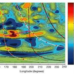
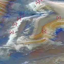
Location of aurora on Mars. Image credit: ESA Click to enlarge
Auroras similar to Earth’s Northern Lights appear to be common on Mars, according to physicists at the University of California, Berkeley, who have analyzed six years’ worth of data from the Mars Global Surveyor.

The discovery of hundreds of auroras over the past six years comes as a surprise, since Mars does not have the global magnetic field that on Earth is the source of the aurora borealis and the antipodal aurora australis.
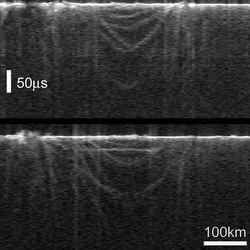
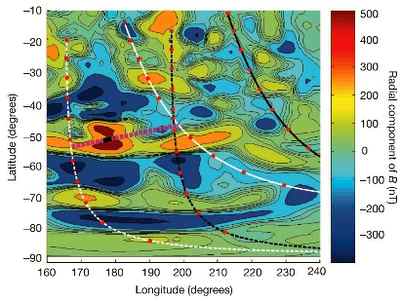
plot of the 13,000 auroral events on Mars

According to the physicists, the auroras on Mars aren’t due to a planet-wide magnetic field, but instead are associated with patches of strong magnetic field in the crust, primarily in the southern hemisphere. And they probably aren’t as colorful either, the researchers say: The energetic electrons that interact with molecules in the atmosphere to produce the glow probably generate only ultraviolet light – not the reds, greens and blues of Earth.

“The fact that we see auroras as often as we do is amazing,” said UC Berkeley physicist David A. Brain, the lead author of a paper on the discovery recently accepted by the journal Geophysical Research Letters. “The discovery of auroras on Mars teaches us something about how and why they happen elsewhere in the solar system, including on Jupiter, Saturn, Uranus and Neptune.”

Brain and Jasper S. Halekas, both assistant research physicists at UC Berkeley’s Space Sciences Laboratory, along with their colleagues from UC Berkeley, the University of Michigan, NASA’s Goddard Space Flight Center and the University of Toulouse in France, also reported their findings in a poster presented Friday, Dec. 9, at the American Geophysical Union meeting in San Francisco.

Last year, the European spacecraft Mars Express first detected a flash of ultraviolet light on the night side of Mars and an international team of astronomers identified it as an auroral flash in the June 9, 2005, issue of Nature. Upon hearing of the discovery, UC Berkeley researchers turned to data from the Mars Global Surveyor to see if an on-board UC Berkeley instrument package – a magnetometer-electron reflectometer – had detected other evidence of auroras. The spacecraft has been orbiting Mars since September 1997 and since 1999 has been mapping from an altitude of 400 kilometers (250 miles) the Martian surface and Mars’ magnetic fields. It sits in a polar orbit that keeps it always at 2 a.m. when on the night side of the planet.

Within an hour of first delving into the data, Brain and Halekas discovered evidence of an auroral flash – a peak in the electron energy spectrum identical to the peaks seen in spectra of Earth’s atmosphere during an aurora. Since then, they have reviewed more than 6 million recordings by the electron reflectometer and found amid the data some 13,000 signals with an electron peak indicative of an aurora. According to Brain, this may represent hundreds of nightside auroral events like the flash seen by the Mars Express.

When the two physicists pinpointed the position of each observation, the auroras coincided precisely with the margins of the magnetized areas on the Martian surface. The same team, led by co-authors Mario H. Acu?a of NASA’s Goddard Space Flight Center and Robert Lin, UC Berkeley professor of physics and director of the Space Sciences Laboratory, has extensively mapped these surface magnetic fields using the magnetometer/reflectometer aboard the Mars Global Surveyor. Just as Earth’s auroras occur where the magnetic field lines dive into the surface at the north and south poles, Mars’ auroras occur at the borders of magnetized areas where the field lines arc vertically into the crust.

Of the 13,000 auroral observations so far, the largest seem to coincide with increased solar wind activity.

“The flash seen by Mars Express seems to be at the bright end of energies that are possible,” Halekas said. “Just as on Earth, space weather and solar storms tend to make the auroras brighter and stronger.”
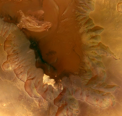
Depiction of surface magnetic fields on Mars

Earth’s auroras are caused when charged particles from the sun slam into the planet’s protective magnetic field and, instead of penetrating to the ground, are diverted along field lines to the pole, where they funnel down and collide with atoms in the atmosphere to create an oval of light around each pole. Electrons are a big proportion of the charged particles, and auroral activity is associated with a physical process still not understood that accelerates electrons, producing a telltale peak in the spectrum of electron energies.

The process on Mars is probably similar, Lin said, in that solar wind particles are funneled around to the night side of Mars where they interact with crustal field lines. The ultraviolet light is produced when the particles hit carbon dioxide molecules.

“The observations suggest some acceleration process occurs like on Earth,” he said. “Something has taken the electrons and given them a kick.”

What that “something” is remains a mystery, though Lin and his UC Berkeley colleagues lean towards a process called magnetic reconnection, where the magnetic field traveling with the solar wind particles breaks and reconnects with the crustal field. The reconnecting field lines could be what flings the particles to higher energies.

The surface magnetic fields, Brain said, are produced by highly magnetized rock that occurs in patches up to 1,000 kilometers wide and 10 kilometers deep. These patches probably retain magnetism left from when Mars had a global field in a way similar to what occurs when a needle is stroked with a magnet, inducing magnetization that remains even after the magnet is withdrawn. When Mars’ global field died out billions of years ago, the solar wind was able to strip the atmosphere away. Only the strong crustal fields are still around to protect portions of the surface.

“We call them mini-magnetospheres, because they are strong enough to stand off the solar wind,” Lin said, noting that the fields extend up to 1,300 kilometers above the surface. Nevertheless, the strongest Martian magnetic field is 50 times weaker than the field at the Earth’s surface. It’s hard to explain how these fields are able to funnel and accelerate the solar wind efficiently enough to generate an aurora, he said.

Brain, Halekas, Lin and their colleagues hope to mine the Mars Global Surveyor data for more information on the auroras and perhaps join with the European team operating the Mars Express to get complementary data on the flashes that could solve the mystery of their origin.

“Mars Global Surveyor was designed for a lifetime of 685 days, but it has been very valuable for more than six years now, and we are still getting great results,” Lin observed.

The work was supported by NASA. Coauthors with Brain, Halekas, Lin and Acu?a are Laura M. Peticolas, Janet G. Luhmann, David L. Mitchell and Greg T. Delory of UC Berkeley’s Space Sciences Laboratory; Steve W. Bougher of the University of Michigan; and Henri R?me of the Centre d’Etude Spatiale des Rayonnements in Toulouse.

Original Source: UC Berkeley News Release

Opportunity Nears its Second Martian Year

Opportunity’s image of an outcrop called “Olympia”. Image credit: NASA Click to enlarge
NASA’s durable twin Mars rovers have successfully explored the surface of the mysterious red planet for a full Martian year (687 Earth days). Opportunity starts its second Martian year Dec. 11; Spirit started a new year three weeks ago. The rovers’ original mission was scheduled for only three months.

“The rovers went through all of the Martian seasons and are back to late summer,” said Dr. John Callas of NASA’s Jet Propulsion Laboratory, Pasadena, Calif. He is deputy rover project manager. “We’re preparing for the challenge of surviving another Martian winter.”

Both rovers keep finding new variations of bedrock in areas they are exploring on opposite sides of Mars. The geological information they have collected increased evidence about ancient Martian environments including periods of wet, possibly habitable conditions.

Spirit is descending from the top of “Husband Hill” to examine a platform-like structure seen from the summit. It will then hurry south to another hill in time to position itself for maximum solar-cell output during the winter.

“Our speed of travel is driven as much by survival as by discovery, though the geology of Husband Hill continues to fascinate, surprise, puzzle and delight us,” said Dr. Steve Squyres of Cornell University, Ithaca, N.Y., principal investigator for the rover’s science instruments. “We’ve got this dramatic topography covered with sand and loose boulders, then, every so often, a little window into the bedrock underneath.”

From the composition and texture of more than six different types of rock inspected, scientists deduced what this part of Mars was like long ago. “It was a hot, violent place with volcanic explosions and impacts,” Squyres said. “Water was around, perhaps localized hot springs in some cases and trace amounts of water in other cases.

Aided by a good power supply from Spirit’s solar cells, researchers have been using the rover at night for astronomical observations. One experiment watched the sky during a meteor shower as Mars passed through the debris trail left by a passage of Halley’s comet. “We’re taking advantage of a unique opportunity to do some bonus science we never anticipated we would be able to do,” Said Cornell’s Dr. Jim Bell, lead scientist for the rovers’ panoramic cameras.

Opportunity is examining bedrock exposures along a route between Endurance and Victoria craters. It recently reached what appears to be a younger layer of bedrock than examined inside Endurance. In Endurance, the lowest layers of bedrock were deposited as windblown dunes. Some of the upper layers were deposited as underwater sediments, indicating a change from drier to wetter conditions over time.

The bedrock Opportunity began seeing about two-thirds of the way to Victoria appears to lie higher than the upper layers at Endurance, but its texture is more like the lowest layer, petrified sand dunes. This suggests the change from drier to wetter environmental conditions may have been cyclical.

Iron-rich granules are abundant in all the layers at Endurance but are much smaller in the younger bedrock. These granules were formed by effects of water soaking the rocks. One possibility for why they are smaller is these layers spent less time wet. Another is the material in these layers had a different chemistry to begin with.

Rover researchers are presenting their latest data today during the American Geophysical Union meeting in San Francisco. Images and information about the rovers and their discoveries are available on the Web at:

http://www.nasa.gov/vision/universe/solarsystem/mer_main.html

Original Source: NASA News Release

Mars Express Confirms Liquid Water Once Existed on Mars’ Surface

Mars Express’s OMEGA instrument adds detail to Candor Chasma. Image credit: ESA Click to enlarge
From previous observations, Mars must have undergone water-driven processes, which left their signature in surface structures such as channel systems and signs of extensive aqueous erosion. However, such observations do not necessarily imply the stable presence of liquid water on the surface over extended periods of time during the Martian history.

The data collected by OMEGA unambiguously reveal the presence of specific surface minerals which imply the long-term presence of large amounts of liquid water on the planet.

These ‘hydrated’ minerals, so called because they contain water in their crystalline structure, provide a clear ‘mineralogical’ record of water-related processes on Mars.

During 18 months of observations OMEGA has mapped almost the entire surface of the planet, generally at a resolution between one and five kilometres, with some areas at sub-kilometre resolution.

The instrument detected the presence of two different classes of hydrated minerals, ‘phyllosilicates’ and ‘hydrated sulphates’, over isolated but large areas on the surface.

Both minerals are the result of a chemical alteration of rocks. However, their formation processes are very different and point to periods of different environmental conditions in the history of the planet.

Phyllosilicates, so-called because of their characteristic structure in thin layers (‘phyllo’ = thin layer), are the alteration products of igneous minerals (minerals of magmatic origin) sustaining a long-term contact with water. An example of phyllosilicate is clay.

Phyllosilicates were detected by OMEGA mainly in the Arabia Terra, Terra Meridiani, Syrtis Major, Nili Fossae and Mawrth Vallis regions, in the form of dark deposits or eroded outcrops.

Hydrated sulphates, the second major class of hydrated minerals detected by OMEGA, are also minerals of aqueous origin. Unlike phyllosilicates, which form by an alteration of igneous rocks, hydrated sulphates are formed as deposits from salted water; most sulphates need an acid water environment to form. They were spotted in layered deposits in Valles Marineris, extended exposed deposits in Terra Meridiani, and within dark dunes in the northern polar cap.

When did the chemical alteration of the surface that led to the formation of hydrated minerals occur? At what point of Mars’s history was water standing in large quantities on the surface? OMEGA’s scientists combined their data with those from other instruments and suggest a likely scenario of what may have happened.

“The clay-rich, phyllosilicate deposits we have detected were formed by alteration of surface materials in the very earliest times of Mars,” says Jean-Pierre Bibring, OMEGA Principal Investigator.

“The altered material must have been buried by subsequent lava flows we observe around the spotted areas. Then, the material would have been exposed by erosion in specific locations or excavated from an altered crust by meteoritic impacts,” Bibring adds.

Analysis of the surrounding geological context, combined with the existing crater counting techniques to calculate the relative age of surface features on Mars, places the formation of phyllosilicates in the early Noachian era, during the intense cratering period. The Noachian era, lasting from the planet’s birth to about 3.8 thousand million years ago, is the first and most ancient of the three geological eras on Mars.

“An early active hydrological system must have been present on Mars to account for the large amount of clays, or phyllosilicates in general, that OMEGA has observed,” says Bibring.

The long-term contact with liquid water that led to the phyllosilicate formation could have existed and be stable at the surface of Mars, if the climate was warm enough. Alternatively, the whole formation process could have occurred through the action of water in a warm, thin crust.

OMEGA data also show that the sulphate deposits are distinct from, and have been formed after, the phyllosilicate ones. To form, sulphates do not need a particularly long-term presence of liquid water, but water must be there and it must be acidic.

The detection and mapping of these two different kinds of hydrated minerals point to two major climatic episodes in the history of Mars: an early ? Noachian ? moist environment in which phyllosilicates formed, followed by a more acid environment in which the sulphates formed. These two episodes were separated by a Mars global climatic change.

“If we look at today’s evidence, the era in which Mars could have been habitable and sustained life would be the early Noachian, traced by the phyllosilicates, rather than the sulphates. The clay minerals we have mapped could still retain traces of a possible biochemical development on Mars,” Bibring concludes.

Original Source:ESA Portal

Mars Express Finds a Buried Impact Crater

MARSIS ‘radargrams’ of buried basin on Mars. Image credit: ESA Click to enlarge
For the first time in the history of planetary exploration, the MARSIS radar on board ESA’s Mars Express has provided direct information about the deep subsurface of Mars.

First data include buried impact craters, probing of layered deposits at the north pole and hints of the presence of deep underground water-ice.

The subsurface of Mars has been so far unexplored territory. Only glimpses of the Martian depths could be deduced through analysis of impact crater and valley walls, and by drawing cross-sections of the crust deduced from geological mapping of the surface.

With measurements taken only for a few weeks during night-time observations last summer, MARSIS – the Mars Advanced Radar for Subsurface and Ionospheric Sounding – is already changing our perception of the Red Planet, adding to our knowledge the missing ‘third’ dimension: the Martian interior.

First results reveal an almost circular structure, about 250 km in diameter, shallowly buried under the surface of the northern lowlands of the Chryse Planitia region in the mid-latitudes on Mars. The scientists have interpreted it as a buried basin of impact origin, possibly containing a thick layer of water-ice-rich material.

To draw this first exciting picture of the subsurface, the MARSIS team studied the echoes of the radio waves emitted by the radar, which passed through the surface and then bounced back in the distinctive way that told the ‘story’ about the layers penetrated.

These echo structures form a distinctive collection that include parabolic arcs and an additional planar reflecting feature parallel to the ground, 160 km long. The parabolic arcs correspond to ring structures that could be interpreted as the rims of one or more buried impact basins. Other echoes show what may be rim-wall ‘slump blocks’ or ‘peak-ring’ features.

The planar reflection is consistent with a flat interface that separates the floor of the basin, situated at a depth of about 1.5 to 2.5 km, from a layer of overlying different material. In their analysis of this reflection, scientists do not exclude the intriguing possibility of a low-density, water-ice-rich material at least partially filling the basin.

“The detection of a large buried impact basin suggests that MARSIS data can be used to unveil a population of hidden impact craters in the northern lowlands and elsewhere on the planet,” says Jeffrey Plaut, Co-Principal Investigator on MARSIS. “This may force us to reconsider our chronology of the formation and evolution of the surface.”

MARSIS also probed the layered deposits that surround the north pole of Mars, in an area between 10? and 40? East longitude. The interior layers and the base of these deposits are poorly exposed. Prior interpretations could only be based on imaging, topographic measurements and other surface techniques.

Two strong and distinct echoes coming from the area correspond to a surface reflection and subsurface interface between two different materials. By analysis of the two echoes, the scientists were able to draw the likely scenario of a nearly pure, cold water-ice layer thicker than 1 km, overlying a deeper layer of basaltic regolith. This conclusion appears to rule out the hypothesis of a melt zone at the base of the northern layered deposits.

To date, the MARSIS team has not observed any convincing evidence for liquid water in the subsurface, but the search has only just begun. “MARSIS is already demonstrating the capability to detect structures and layers in the subsurface of Mars which are not detectable by other sensors, past or present,” says Giovanni Picardi, MARSIS Principal Investigator.

“MARSIS holds exciting promise to address, and possibly solve, a number of open questions of major geological significance,” he concluded.

Original Source:ESA Portal