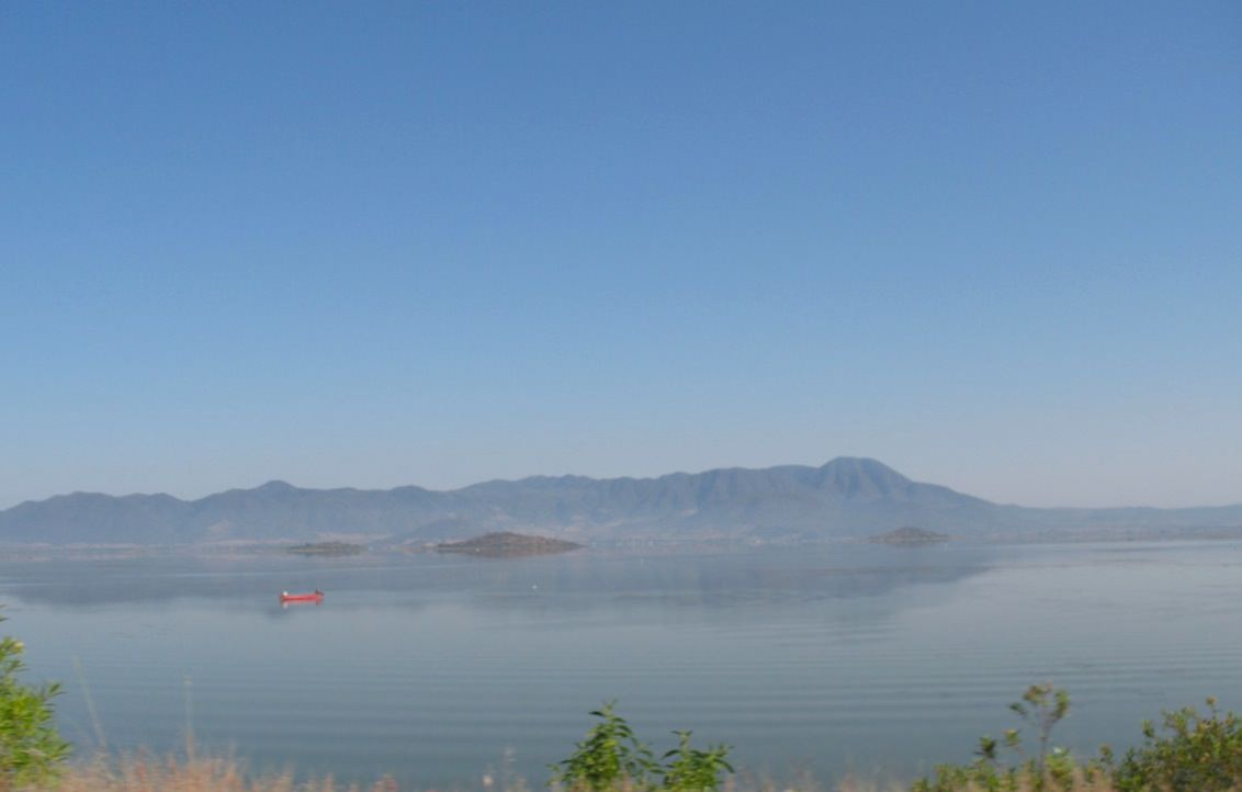
Lake Cuitzeo in central Mexico. (Via Julio Marquez, Wikipedia Commons)
[/caption]
Exotic sediments found beneath the floor of Lake Cuitzeo in central Mexico support theories of a major cosmic impact event 12,900 years ago, report a 16-member international research team. The impact may have caused widespread environmental changes and contributed to the extinctions of many large animal species.
Images of single and twinned nanodiamonds show the atomic lattice framework of the nanodiamonds. Each dot represents a single atom. (Source: UCSB release.)
The team found a 13,000-year-old layer of sediment that contains materials associated with impact events, such as soot, impact spherules and atomic-scale structures known as nanodiamonds. The nanodiamonds found at Lake Cuitzeo are of a variety known as lonsdaleite, even harder than “regular” diamond and only found naturally as the result of impact events.
The thin layer of sediment below Cuitzeo corresponds to layers of similar age found throughout North America, Greenland and Western Europe.
It’s thought that a large several-hundred-meter-wide asteroid or comet entered Earth’s atmosphere at a shallow angle 12,900 years ago, melting rocks, burning biomass and, in general, causing widespread chaos and destruction. This hypothesized event would have occurred just before a period of unusually cold climate known as the Younger Dryas.
The Younger Dryas has been associated with the extinction of large North American animals such as mammoths, saber-tooth cats and dire wolves.
“The timing of the impact event coincided with the most extraordinary biotic and environmental changes over Mexico and Central America during the last approximately 20,000 years, as recorded by others in several regional lake deposits,” said James Kennett, professor of earth science at UC Santa Barbara and member of the research team. “These changes were large, abrupt, and unprecedented, and had been recorded and identified by earlier investigators as a ‘time of crisis.’ ”
The exotic materials found in the sediment beneath Cuitzeo could not have been created by any volcanic, terrestrial or man-made process. “These materials form only through cosmic impact,” Kennett said.
The only other widespread sedimentary layer ever found to contain such an abundance of nanodiamonds and soot is found at the K-T boundary, 65 million years ago. This, of course, corresponds to the impact event that led to the extinction of the dinosaurs.
The researchers’ findings appeared March 5 in the Proceedings of the National Academy of Sciences. Read the news release from UC Santa Barbara here.
he launch of the Phoenix spacecraft on a Delta II rocket in 2007. NASA is looking for alternatives to hydrazine monopropellant, used en route by Phoenix's navigational thrusters Image credit: NASA/Sandra Joseph and John Kechele
[/caption]
NASA announced yesterday that it’s looking for new technology proposals using environmentally friendly fuels to launch payload. The space agency is hoping to move away from hydrazine, the fuel that currently launches anything that travels beyond the atmosphere from commercial satellites to private spaceflight and exploration probes.
As a rocket propellant, hydrazine is great. It’s incredibly efficient, can be stored for long periods of time, has excellent handling characteristics, is stable up to 250 degrees Celsius (482 Fahrenheit) under normal conditions, and decomposes cleanly.
It also happens to be extremely toxic.
Shifting away from hydrazine would be a shift away from known environmental hazards and pollutants. There would be fewer operational hazards for those dealing with fueled rockets before launch. The change could also simplify the complexity of the rockets’ systems and, possibly, increase overall propellant performance.
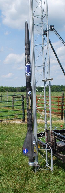
The ALICE powered rocket before launch. Image credit: Dr. Steven F. Son, Purdue University
The benefits don’t stop there. Advantages on every level trickle down. “High performance green propulsion has the potential to significantly change how we travel in space,” said Michael Gazarik, director of NASA’s Space Technology Program at the agency’s headquarters in Washington. “By reducing the hazards of handling fuel, we can reduce ground processing time and lower costs for rocket launches, allowing a greater community of researchers and technologists access to the high frontier.”
Developing green propellants won’t be quick or easy. It will be a major challenge for NASA, particularly from a cost, schedule, and risk perspective. The agency has established the Technology Demonstration Missions Program at the Marshall Spaceflight Centre in Huntsville, Alabama to oversee the green fuel program. It will act as a bridge between laboratory confirmation of a technology and its use on a mission.
This isn’t the first time NASA has tried to develop green fuel. In 2009, the space agency and the US Air Force successfully launched a 9-foot rocket 1,300 vertical feet using a mixture of aluminum powder and water ice. The mixture, called ALICE, has been studied since the 1960s as an alternative propellant. The reaction between substances produces a large amount of energy during combustion and green exhaust products.
Environmental impact aside, fuels like ALICE could be manufactured on the Moon or Mars, negating the cost of sending propellants along as cargo on long-duration missions. This would be when designing long-term missions.
The winning aircraft - Pipistrel-USA, Taurus G4 - during its flight as part of the miles per gallon flight. (NASA/Bill Ingalls)
Aviation, too has been an outlet for NASA’s green fuel initiatives in the past. 2011’s CAFE Green Flight Challenge, sponsored by Google, had competitors in general aviation design aircraft capable of flying 200 miles in less than two hours and use less than one gallon of fuel per passenger. The first place winner of $1.35 million was the team Pipistrel-USA.com of State College, Pennsylvania used an electric aircraft that achieved twice the fuel efficiency required by the competition — they flew 200 miles on the equivalent of a half-gallon of fuel per passenger.
With this shift to green fuels, NASA hopes to partner with American companies to usher in a new environmentally friendly era of open access to space. The agency is planing to make multiple contract awards for green technologies with no single away exceeding $50 million.
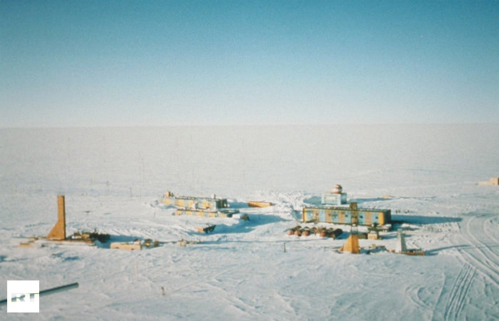
Panoramic photo of Vostok Station showing the layout of the camp. Credit: Todd Sowers LDEO, Columbia University, Palisades, New York (Image from physorg.com)
[/caption]
Sealed off for millions of years beneath an almost impenetrable layer of ice, Lake Vostok has kept a vast archive of ancient history waiting for just the right moment to reveal itself. Here is a unique closed ecosystem captured in time below four kilometers of ice. Saved from environmental contamination, its water has been isolated from Earth’s atmosphere, and the outside world, long before man existed. Only one burning question remains… Could this pristine pocket of Lake Vostok show signs of early life?
“According to our research, the quantity of oxygen there exceeds that on other parts of our planet by 10 to 20 times. Any life forms that we find are likely to be unique on Earth,” says Sergey Bulat, the Chief Scientist of Russia’s Antarctic Expedition to Russian Reporter magazine.
So why be so excited over finding a few organisms? The reason is clear as the hidden waters. If a life form could exist here, it could also exist on a similar world…. Jupiter’s satellite, Europa.
“The discovery of microorganisms in Lake Vostok may mean that, perhaps, the first meeting with extra-terrestrial life could happen on Europa,” said Dr Vladimir Kotlyakov, Director of the Geography Institute at the Russian Academy of Sciences to Vzglyad newspaper.
Image from earth.columbia.eduHowever, drilling through over 3,700 meters of pure ice hasn’t been an easy process – especially when you’re working in temperatures as low as minus 80 centigrade. The chill thrill drill began in 1970, but it was over 25 years later before Russian specialists discovered the hidden lake beneath the ice sheet. Along with British support, they then began sonar and satellite imagining to reveal one of the world’s largest undisclosed fresh water reservoirs. Now, speculation began in earnest. What might these waters contain? Could it be tiny microbes? Or perhaps even a dangerous organism… There was only one way to find out. Drill and sample.
“Everything but the samples themselves will be carefully decontaminated using radiation. There is no need to worry,” Valeriy Lukin, Head of the Antarctic Expedition told Russian Reporter Magazine. According to researchers at the Russian Arctic and Antarctic Research Institute, they surmise the findings as “the only giant super-clean water system on the planet.” and pristine water will be “twice cleaner than double-distilled water.”
Over the last few decades, there had been a lot of discord over anti-freeze drilling methods – each with its pros and cons. From kerosene to Freon – even hot water – the end result needed to be the same. No chance of contamination… either to the samples or the native environment. As it ended up, the Russian method of using the former turned out to be fine when 40 liters of frozen, pure water came to light on February 4. Just a day later, 1,500 liters of kerosene and Freon poured into special containers with no problems and the sample proved to be immaculate. The clear waters are now safely tucked away in sterile containers and are heading back home.
“I can say that everyone at Bellingshausen on the Antarctic Peninsula could probably tell you down to the meter what the daily progress of the drilling was at the Vostok Station in the center of the continent.” says reporter, Sean Thomas. ” After all, the work at Lake Vostok was a Russian project, at a Russian base with Russian scientists, so there is a lot of pride in the work that is being done there.”
According to conventional thinking, plant life first took hold on Earth after oceans and rivers formed; the soil produced by liquid water breaking down bare rock provided an ideal medium for plants to grow in. It certainly sounds logical, but a new study is challenging that view – the theory is that vascular plants, those containing a transport system for water and nutrients, actually created a cycle of glaciation and melting, conditions which led to the formation of rivers and mud which allowed forests and farmland to later develop. In short, they helped actually create the landscapes we see today.
The evidence was just published in two articles in a special edition of Nature Geoscience.
In the first article, analysis of the data proposes that vascular plants began to absorb the carbon dioxide in the atmosphere about 450 million years ago. This led to a cooling of temperatures on a global scale, resulting in widespread glaciation. As the glaciers later started to melt, they ground up the Earth’s surface, forming the kind of soils we see today.
The second article goes further, stating that today’s rivers were also created by vascular plants – the vegetation broke the rocks down into mud and minerals and then also held the mud in place. This caused river banks to start forming, acting as channels for water, which up until then had tended to flow over the surface much more randomly. As the water was channeled into more specific routes, rivers formed. This led to periodic flooding; sediments were deposited over large areas which created rich soil. As trees were able to take root in this new soil, debris from the trees fell into the rivers, creating logjams. This had the effect of creating new rivers and causing more flooding. These larger fertile areas were then able to support the growth of larger lush forests and farmland.
According to Martin Gibling, a professor of Earth science at Dalhousie University, “Sedimentary rocks, before plants, contained almost no mud. But after plants developed, the mud content increased dramatically. Muddy landscapes expanded greatly. A new kind of eco-space was created that wasn’t there before.”
The new theory also leads to the possibility that any exoplanets that happen to have vegetation would look different from Earth; varying circumstances would create a surface unique to each world. Any truly Earth-like exoplanets might be very similar in general, but the way that their surfaces have been modified might be rather different.
It’s an interesting scenario, but it also raises other questions. What about the ancient river channels on Mars? Some appear to have been formed by brief catastrophic floods, but others seem more similar to long-lived rivers here on Earth, especially if there actually was a northern hemisphere ocean as well. How did they form? Does this mean that rivers could form in a variety of ways, with or without plant life being involved? Could Mars have once had something equivalent to vascular plant life as well? Or could the new theory just be wrong? Then there’s Titan, which has numerous rivers still flowing today. Albeit they are liquid methane/ethane instead of water, but what exactly led to their formation?
Without the workings of life, the Earth would not be the planet it is today. Even if there are a number of planets that could support tectonics, running water and the chemical cycles that are essential for life as we know it, it seems unlikely that any of them would look like Earth. Even if evolution follows a predictable path, filling all available niches in a reproducible and consistent way, the niches on any Earth analogue could be different if the composition of its surface and atmosphere are not identical to those of Earth. And if evolution is random, the differences would be expected to be even larger. Either way, a glimpse of the surface of an exoplanet — if we ever get one — may give us a whole new perspective on biogeochemical cycling and geomorphology.
Just as the many exoplanets now being found are of a previously unknown and amazingly wide variety, and all uniquely alien, even the ones that (may) support life are likely to be just as diverse from each other as they are from Earth itself. Earth’s “twin” may be out there, but in terms of outward appearance, it may be somewhat more of a fraternal twin than an exact replica.
Gifford Miller collects vegetation samples on Baffin Island. (Photo courtesy University of Colorado Boulder.)
[/caption]
In a study led by the University of Colorado Boulder with co-authors at the National Center for Atmospheric Research (NCAR) and other organizations, researchers may have possibly found evidence the “Little Ice Age” may have had ties to an unusual era of volcanic activity… one that lasted for about 50 years. In just five decades, four massive tropical volcanic eruptions managed to take Earth’s entire environment and put it on ice. Somewhere near the years between 1275 and 1300 A.D., these eruptions caused some very cool summer weather in the northern hemisphere which triggered an expansion of sea ice that – in turn – weakened Atlantic currents. However, it didn’t weaken the already cool climate. It strengthened it.
The international study was done in layers – like a good cake – but instead of sweet frosting, it was a composite look at dead vegetation, ice and sediment core data. By engaging highly detailed computer climate modeling, scientists are now able to have a strong theory of what triggered the Little Ice Age.. a theory which begins with decreased summer solar radiation and progresses through erupting volcanoes. Here planet-wide cooling could have been started by sulfates and other aerosols being ejected into our atmosphere and reflecting sunlight back into space. Simulations have shown it could have even been a combination of both scenarios.
“This is the first time anyone has clearly identified the specific onset of the cold times marking the start of the Little Ice Age,” says lead author Gifford Miller of the University of Colorado Boulder. “We also have provided an understandable climate feedback system that explains how this cold period could be sustained for a long period of time. If the climate system is hit again and again by cold conditions over a relatively short period—in this case, from volcanic eruptions—there appears to be a cumulative cooling effect.”
“Our simulations showed that the volcanic eruptions may have had a profound cooling effect,” says NCAR scientist Bette Otto-Bliesner, a co-author of the study. “The eruptions could have triggered a chain reaction, affecting sea ice and ocean currents in a way that lowered temperatures for centuries.” The team’s research papers will be published this week in Geophysical Research Letters. Members of the group include co-authors from the University of Iceland, the University of California Irvine, and the University of Edinburgh in Scotland. The study was funded in part by the National Science Foundation, NCAR’s sponsor, and the Icelandic Science Foundation.
“Scientific estimates regarding the onset of the Little Ice Age range from the 13th century to the 16th century, but there is little consensus,” Miller says. It’s fairly clear these lower temperatures had an impact on more southerly regions such as South American and China, but the effect was far more clear in areas such as northern Europe. Glacial movement eradicated populated regions and historical images show people ice skating in places known to be too warm for such solid freezing activities before the Little Ice Age.
“The dominant way scientists have defined the Little Ice Age is by the expansion of big valley glaciers in the Alps and in Norway,” says Miller, a fellow at CU’s Institute of Arctic and Alpine Research. “But the time in which European glaciers advanced far enough to demolish villages would have been long after the onset of the cold period.”
By employing the technique of radiocarbon dating, approximately 150 plant specimens, complete with roots, were gathered from the receding edges of ice caps located on Baffin Island in the Canadian Artic. In these samples they found evidence of a “kill date” which ranged between 1275 and 1300 A.D. This information led the team to surmise the plants were quickly frozen and then just as quickly encased in solid ice. A second documented kill date occurred about 1450 A.D. showing another major event. To further flesh out their findings, the research team took sediment sample cores from a glacial lake which is linked to the mile-high Langikull ice cap. These important samples from Iceland can be reliably dated back as far as 1,000 years and the results showed a sudden increase in ice during the late 13th century and again in the 15th. Thanks to these techniques which rely on the presence tephra deposits, we know these climate cooling events occurred as a result of volcanic eruptions.
“That showed us the signal we got from Baffin Island was not just a local signal, it was a North Atlantic signal,” Miller says. “This gave us a great deal more confidence that there was a major perturbation to the Northern Hemisphere climate near the end of the 13th century.”
What brought the team to their final conclusions? Through the use of the Community Climate System Model developed by scientists at NCAR and the Department of Energy with colleagues at other organizations, they were able to simulate the impact of volcanic cooling on the extent and mass of Artic sea ice. The model painted a portrait of what could have occurred from about 1150 to 1700 A.D. and showed that some large scale eruptions could have impacted the northern hemisphere if they happened within a close time frame. In this scenario, the long term cooling effect could have expanded the Artic Sea ice to the point where it eventually met – and melted – in the North Atlantic. During the modeling, the solar radiation was set at a constant to show ” the Little Ice Age likely would have occurred without decreased summer solar radiation at the time.” concluded Miller.
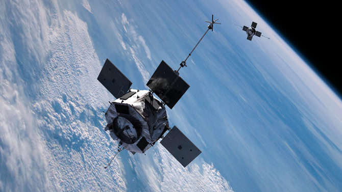
Artist concept of the twin Radiation Belt Storm Probes spacecraft, scheduled for launch in August 2012. Credit: NASA
[/caption]
During the 1950s and just before the great “Space Race” began, scientists like Kristian Birkeland, Carl Stormer, and Nicholas Christofilos had been paying close attention to a theory – one that involved trapped, charged particles in a ring around the Earth. This plasma donut held in place by our planet’s magnetic field was later confirmed by the first three Explorer missions under the direction of Dr. James Van Allen. Fueled by perhaps solar winds, or cosmic rays, the knowledge of their existence was the stuff of nightmares for an uniformed public. While the “radiation” can affect objects passing through it, it doesn’t reach Earth, and this realization quickly caused fears to die. However, there are still many unanswered questions about the Van Allen Radiation Belts that mystify modern science.
Over the years we’ve learned these radiation zones are comprised of electrons and energetically charged particles. We’ve documented the fact they can both shrink and swell according to the amount of solar energy they receive, but what researchers haven’t been able to pinpoint is exactly what causes these responses. Particles come and particles go – but there isn’t a solid answer without evidence. A pertinent question has been to determine if particles escape into interplanetary space when the belts shrink – or do they fall to Earth? Up until now, it’s been an enigma, but a new study employing several spacecraft at the same time has been to trace the particles and follow the trail up.
“For a long time, it was thought particles would precipitate downward out of the belts,” says Drew Turner, a scientist at the University of California, Los Angeles, and first author on a paper on these results appearing online in Nature Physics on January 29, 2012. “But more recently, researchers theorized that maybe particles could sweep outward. Our results for this event are clear: we saw no increase in downward precipitation.”
From October to December 2003, the radiation belts swelled and shrank in response to geomagnetic storms as particles entered and escaped the belts. Credit: NASA/Goddard Scientific Visualization Studio
This isn’t just a simple answer to simple question, though. Understanding the movement of the particles can play a critical role in protecting our satellite systems as they pass through the Van Allen Belts – and its far reaching radiation extensions. As we know, the Sun produces copious amounts of charged particles in the stellar winds and – at times – can blast in our direction during coronal mass ejections (CMEs) or shock fronts caused by fast solar winds overtaking slower winds called co-rotating interaction regions -CIRs). When directed our way, they disrupt Earth’s magnetosphere in an event known as a geomagnetic storm. During a “storm” the radiation belt particles have been known to decrease and empty the belt within hours… a depletion which can last for days. While this is documented, we simply don’t know the cause, much less what causes the particles to leave!
In order to get a firmer grip on what’s happening requires multiple spacecraft measuring the changes at multiple points at the same time. This allows scientists to determine if an action that happens in one place affects another elsewhere. While we look forward to the Radiation Belt Storm Probes (RBSP) mission results, it isn’t scheduled to launch until August 2012. In the interim, researchers have combined data from two widely separated spacecraft to get an early determination of what happens during a loss event.
“We are entering an era where multi-spacecraft are key,” says Vassilis Angelopoulos, a space scientist at UCLA, and the principal investigator for THEMIS and a coauthor on the paper. “Being able to unite a fleet of available resources into one study is becoming more of a necessity to turn a corner in our understanding of Earth’s environment.”
So where did this early support information come from? Fortunately the team was able to observe a small geomagnetic storm which occurred on January 6, 2011. By engaging the the three NASA THEMIS (Time History of Events and Macroscale Interactions during Substorms) spacecraft, two GOES (Geostationary Operational Environment Satellite), operated by the National Oceanic and Atmospheric Administration (NOAA), and six POES (Polar Operational Environmental Satellite), run jointly by NOAA, and the European Organization for the Exploitation of Meteorological Satellites (EUMETSAT) spacecraft, they were able to catch electrons moving close to the speed of light as they dropped out of the belt for over six hours. Orbiting Earth’s equatorial zones, the THEMIS and GOES spacecraft are just part of the team. The POES spacecraft passes through the radiation belts several times a day as it cruises at a lower altitude and near the poles. By combining data, the scientists were able to take several observational vantage points and proved – without a doubt – that the particles left the belt by way of space and did not return to Earth.
“This was a very simple storm,” says Turner. “It’s not an extreme case, so we think it’s probably pretty typical of what happens in general and ongoing results from concurrent statistical studies support this.”
During this time, the spacecraft also observed a low-density area of the Van Allen belts which appeared along the periphery and traveled inward. This appeared to be an indication the particles were outward bound. If this was a normal occurrence, it stands to reason that a type of “wave” must assist the motion, allowing the particles to reach the outer escape boundary. Discovering just what exactly triggers this escape mechanism will be one of the jobs for RBSP, says David Sibeck at NASA’s Goddard Space Flight Center in Greenbelt, Md., who is NASA’s mission scientist for RBSP and project scientist for THEMIS.
“This kind of research is a key to understanding, and eventually predicting, hazardous events in the Earth’s radiation belts,” says Sibeck. “It’s a great comprehensive example of what we can expect to see throughout the forthcoming RBSP mission.”
Clouds play a vital role in Earth's energy balance, cooling or warming Earth's surface depending on their type. This painting, "Cumulus Congestus," by JPL's Graeme Stephens, principal investigator of NASA's CloudSat mission, depicts cumulus clouds, which transport energy away from Earth's surface. Image credit: Graeme Stephens
[/caption]
Like many of us, Earth works on a budget – an energy budget. However, this energy isn’t the type that powers our automobiles or electric lights. It’s the energy that empowers our living planet. When it comes to input and output, the Earth is a huge throughput system. The most massive source of incoming energy is solar radiation, with geothermal and tidal energy completing the circle. All of these forms of energy are converted to heat and re-radiated into space. In 2010, scientists at the National Center for Atmospheric Research in Boulder, Colorado publicized a study taken from satellite observations which stated there were certain variances between Earth’s heat and ocean heating. What they found was “missing energy” in our planet’s system. Why did this energy seem to be disappearing? The research group began wondering if perhaps there was a problem with the method of recording energy as absorbed from the Sun and its emission back to space.
This was a question that needed an answer. Enter an international team of atmospheric scientists and oceanographers, led by Norman Loeb of NASA’s Langley Research Center in Hampton, Virginia, and including Graeme Stephens of NASA’s Jet Propulsion Laboratory in Pasadena, California. It was their mission to account for the missing energy. Armed with 10 years of data from NASA Langley’s orbiting Clouds and the Earth’s Radiant Energy System Experiment (CERES) instruments, the team set out to record the radiation balance located at the apex of Earth’s atmosphere and how it changed with time. Supplied with the CERES data, they then combined it with estimates of oceanic heat content as recorded by three separate sensors. Their findings showed that both satellite and physical measurements of the ocean’s energy agreed with one another once observational uncertainties were added to the equation. Their work was summarized in a NASA-led study published January 22 in the journal Nature Geosciences,
“One of the things we wanted to do was a more rigorous analysis of the uncertainties. When we did that, we found the conclusion of missing energy in the system isn’t really supported by the data.” said Loeb. “Our data shows that Earth has been accumulating heat in the ocean at a rate of half a watt per square meter (10.8 square feet), with no sign of a decline. This extra energy will eventually find its way back into the atmosphere and increase temperatures on Earth.”
For the most part, scientists concur that around 90% of extra heat created by the greenhouse gas effect is being stored in Earth’s oceans. If it follows the laws of thermodynamics and is released back into the atmosphere, “a half-watt per square meter accumulation of heat could increase global temperatures by 0.3 or more degrees centigrade or 0.54 degree Fahrenheit”. As Loeb explained, these observations show the need to employ several different measuring systems over time and the findings underline the imperative need to continually update how Earth’s energy flows are recorded.
The newly published work came from the science team at the National Center for Atmospheric Research and other authors of the paper are from the University of Hawaii, the Pacific Marine Environmental Laboratory in Seattle, the University of Reading United Kingdom and the University of Miami. Their study mapped inconsistencies between satellite information on Earth’s heat balance between the years of 2004 and 2009 and included information on the rate of oceanic heating taken from the upper 700 meters of the surface. They said the inconsistencies were evidence of “missing energy.”
[/caption]Are you a fan of Citizen Science? Do you enjoy participating in projects that help researchers and possibly the environment?
GLOBE at Night is one such program! By taking naked-eye observations of the night sky in your area, you can help a world-wide effort to track the effects of light pollution.
Here’s all the info you need in order to participate in GLOBE at Night during 2012.
For starters, what is GLOBE at Night?
The GLOBE at Night program is an international citizen-science campaign designed to raise public awareness of the impact of light pollution on our night skies. GLOBE at Night aims to raise awareness by inviting citizen-scientists to measure their night sky brightness and submit their observations to a website from a computer or smart phone.
Light pollution not only threatens our “right to starlight”, but also affects energy consumption, wildlife and health. For the past six years, the GLOBE at Night campaign has been involving people in 115 countries.
Participating in GLOBE at Night requires only five easy steps:
Map of 2011 GLOBE at Night participation. Image Credit: GLOBE at Night / NOAO
You can also use the new web application data submission process. The GLOBE at Night website is easy to use, comprehensive and holds an abundance of background information. The database is usable for comparisons with a variety of other databases, like how light pollution affects the foraging habits of bats.
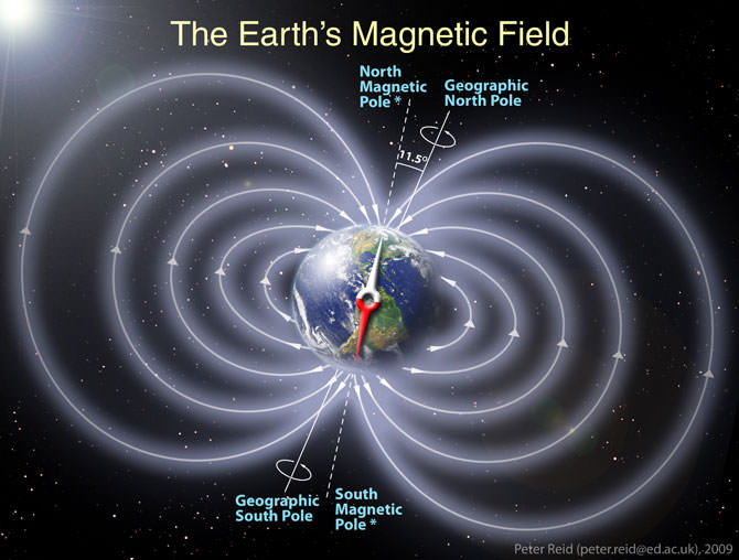
Schematic illustration of Earth's magnetic field. Credit/Copyright: Peter Reid
[/caption]
Have you heard or read stories about how Earth will some day reverse its magnetic poles? If you have, then chances are very good you’ve also heard this perfectly normal function of our planet could spell disaster. Before you buy into another “end of the world as we know it” scenario, let’s take a look at the facts.
For the record, we know that Earth’s magnetic field has changed its polarity more than once in its lifetime. For example, if you could step back in time some 800,000 years ago with a compass in your hand, you’d see the needle pointed to south – instead of north. Why? Because a compass works on magnetic fields, its needle directs you to the magnetic pole, measured as either positive or negative. The markings on the modern compass dial would be incorrect if the polarity of Earth’s magnetic fields were reversed! Like a witch hunt, many would-be prophets say natural occurrences like this might signal doom… But could their theories be correct? Unfortunately for hyperbole, the geologic and fossil records from past reversals show the answer is “No.” We’ll still be around.
Just like the Sun reversing its magnetic poles, Earthly switches are just a part of our planet’s schedule. During about the last 20 million years of our formation, Earth has settled into a pattern of switching magnetic poles about every 200,000 to 300,000 years… with a period of twice that long since our last reversal. And, it’s not a thing that happens rapidly. Magnetic pole reversal takes up to several hundred thousands of years to complete. The fields blend together and magnetic poles pop up at odd latitudes as it happens. It’s not that scary! Scientists say that Earth has reversed its magnetic field hundreds of times over the last three billion years and have sped up slightly with time.
How do we know about the impacts of magnetic pole reversal? We take a look at the deep evidence – sediment cores taken from the ocean floor. These samples are perfect fossil records which show us what direction the magnetic field was pointed in as the underwater lava emerged. These ancient flows were magnetized in the field’s direction at the time of their creation and exist on either side of the Mid-Atlantic Rift where the North American and European continental plates are moving away from each other.
“The last time that Earth’s poles flipped in a major reversal was about 780,000 years ago, in what scientists call the Brunhes-Matuyama reversal. The fossil record shows no drastic changes in plant or animal life.” says NASA’s Patrick Lynch. ” Deep ocean sediment cores from this period also indicate no changes in glacial activity, based on the amount of oxygen isotopes in the cores. This is also proof that a polarity reversal would not affect the rotation axis of Earth, as the planet’s rotation axis tilt has a significant effect on climate and glaciation and any change would be evident in the glacial record.”
A schematic diagram of Earth's interior and the movement of magnetic north from 1900 to 1996. The outer core is the source of the geomagnetic field. Graphic Credit: Dixon RohrUnlike a hard-wired magnet, Earth’s polarity isn’t constant – it moves around a bit. The reason we have a magnetic field is our solid iron core surrounding by hot, fluid metal. According to computer modeling, this flow creates electric currents which spawn the magnetic fields. While it’s not possible at this point in time to measure the outer core of our planet directly, we can guess at its movement by the changes in the magnetic field. One such change has occurred for almost 200 years now… Our northern pole has been shifting even more northward. Since it was first located, the pole has shifted its place by more than 600 miles (1,100 km)! What’s more, it’s speeding up. It would seem that it’s moving almost 40 miles per year now, instead of the 10 miles per year as recorded in the early 20th century.
Don’t be fooled by those saying a magnetic pole reversal would leave us temporarily without a magnetic field, either. This is simply isn’t going to happen and we’re not going to be exposed to harmful solar activity. While our magnetic field goes through weaker and stronger phases, there is simply no evidence to be found anywhere that it has ever disappeared completely. Even if it were weakened, our atmosphere would protect us against incoming particles and we’d have more auroral displays at lower latitudes!
So, go ahead… Sleep at night. Earthly magnetic pole reversal is a normal function of our planet and when it does happen its effects will be spread out over hundreds of thousands of years – not flipped like a pancake.
Roughly 2.4 billion years ago, Earth’s atmosphere underwent a huge change known as the “Great Oxidation Event”. This switch from an oxygen-poor to an oxygen-rich environment may be accountable for giving rise to life. However, scientists are extremely curious about what our atmosphere may have been like not long after our planet formed. Now researchers from the New York Center for Astrobiology at Rensselaer Polytechnic Institute are using some of the oldest minerals known to exist to help understand what may have occurred some five million years after Earth arose.
For the most part, scientists have theorized that early-Earth atmosphere was dominated by noxious methane, carbon monoxide, hydrogen sulfide, and ammonia. This highly reduced mixture results in a limited amount of oxygen and has led to a wide variety of theories about how life may have started in such a hostile environment. However, by taking a closer look at ancient minerals for oxidation levels, scientists at Rensselaer have proved the early-Earth atmosphere wasn’t like that at all… but held copious amounts of water, carbon dioxide, and sulfur dioxide.
“We can now say with some certainty that many scientists studying the origins of life on Earth simply picked the wrong atmosphere,” said Bruce Watson, Institute Professor of Science at Rensselaer.
How can they be so sure? Their findings depend on the theory that Earth’s atmosphere was formed volcanically. Each time magma flows to the surface, it releases gases. If it doesn’t come to the top, then it interacts with the surrounding rocks where it cools and becomes a rocky deposit in its own right. These deposits – and their elemental construction – allows science to paint an accurate portrait of the conditions at the time of their formation.
“Most scientists would argue that this outgassing from magma was the main input to the atmosphere,” Watson said. “To understand the nature of the atmosphere ‘in the beginning,’ we needed to determine what gas species were in the magmas supplying the atmosphere.”
One of the most important of all magma components is zircon – a mineral nearly as old as Earth itself. By determining the oxidation levels of the magmas that formed these ancient zircons, scientists are able to deduce how much oxygen was being released into the atmosphere.
“By determining the oxidation state of the magmas that created zircon, we could then determine the types of gases that would eventually make their way into the atmosphere,” said study lead author Dustin Trail, a postdoctoral researcher in the Center for Astrobiology.
To enable their work, the team set about cooking up magma in a laboratory setting – which led to the creation of an oxidation gauge to assist them in comparing their artificial specimens against natural zircons. Their study also included a watchful eye for a rare Earth metal called cerium that can exist in two oxidation states. By exposing cerium in zircon, the team can be confident the atmosphere was more oxidized after their creation. These new findings point to an atmospheric state more like our present day conditions… setting the stage for a new starting point on which to base life’s beginnings on Earth.
“Our planet is the stage on which all of life has played out,” Watson said. “We can’t even begin to talk about life on Earth until we know what that stage is. And oxygen conditions were vitally important because of how they affect the types of organic molecules that can be formed.”
While “life as we know it” is highly dependent on oxygen, our current atmosphere probably isn’t the ideal model for spawning primordial life. It’s more likely a methane-rich atmosphere might “have much more biologic potential to jump from inorganic compounds to life-supporting amino acids and DNA.” This leaves the door wide open to alternate theories, such as panspermia. But don’t sell the team’s results short. They still reveal the beginning nature of gases here on Earth, even if they don’t solve the riddle of the Great Oxidation Event.
Original Story Source: Rensselaer Polytechnic Institute News Release.