NASA's Mars Curiosity Rover captures a selfie to mark a full Martian year -- 687 Earth days -- spent exploring the Red Planet. Curiosity Self-Portrait was taken at the 'Windjana' Drilling Site in April and May 2014 using the Mars Hand Lens Imager (MAHLI) camera at the end of the roboic arm. Credit: NASA/JPL-Caltech/MSSS
Here’s the latest interactive panorama via panoramacist Andrew Bodrov from imagery taken by the Curiosity Mars at Gale Crater, from Sol 647 (May 1, 2014).
The images for panorama were obtained by the rover’s 34-millimeter Mast Camera. The mosaic, which stretches about 30,000 pixels width, includes 134 images, all taken on Sol 647.
You can see previous interactive panoramas from Andrew of of Curiosity’s images here.
And in case you missed it, here’s Curiosity’s latest “Selfie”:
NASA's Mars Curiosity Rover captures a selfie to mark a full Martian year -- 687 Earth days -- spent exploring the Red Planet. Curiosity Self-Portrait was taken at the 'Windjana' Drilling Site in April and May 2014 using the Mars Hand Lens Imager (MAHLI) camera at the end of the roboic arm. Credit: NASA/JPL-Caltech/MSSS
NASA’s Curiosity rover celebrated a milestone anniversary today, June 24 – 1 Martian Year on Mars!
A Martian year is equivalent to 687 Earth days, or nearly two Earth years.
NASA marked the illustrious achievement with the release of a new ‘selfie’ captured recently while drilling deep into the Red Planet to unlock the secrets of Mars hidden past eons ago when the planet was far warmer and wetter and more conducive to the origin of life.
Curiosity’s new self-portrait was taken at the ‘Windjana’ Drilling Site in April and May 2014 using the Mars Hand Lens Imager (MAHLI) camera at the end of the robotic arm.
As of today the 1 ton rover has been exploring the alien surface for a full Martian year since her nail biting touchdown inside Gale Crater on Aug. 5, 2012 – using the unprecedented sky crane maneuver which culminated in a rocket assisted touchdown astride a humongous mountain named Mount Sharp.
Mount Sharp dominates the center of Gale Crater and reaches 3.4 miles (5.5 km) into the Martian sky – taller than Mount Rainier.
During Mars Year 1 on Mars, Earth’s metallic emissary has already accomplished her primary objective of discovering a habitable zone on the Red Planet that contains the chemical ingredients necessary to support microbial life in the ancient past.
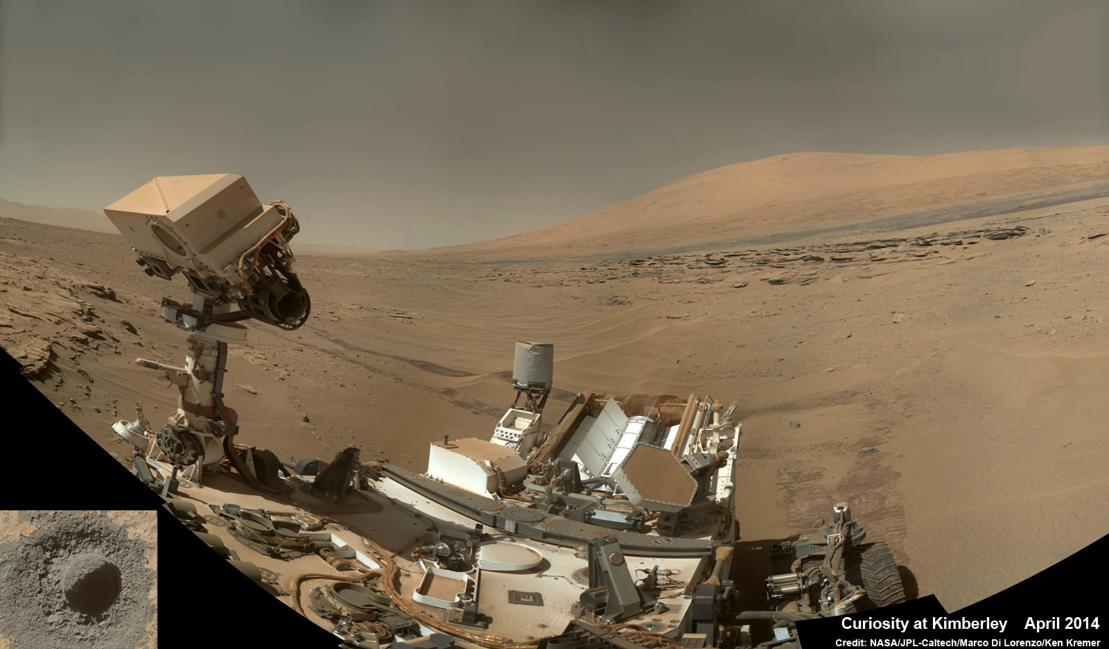
Curiosity rover panorama of Mount Sharp captured on June 6, 2014 (Sol 651) during traverse inside Gale Crater. Note rover wheel tracks at left. She will eventually ascend the mountain at the ‘Murray Buttes’ at right later this year. Assembled from Mastcam color camera raw images and stitched by Marco Di Lorenzo and Ken Kremer. Credit: NASA/JPL/MSSS/Marco Di Lorenzo/Ken Kremer-kenkremer.com
During 2013, Curiosity conducted the first two drill campaigns at the ‘John Klein’ and ‘Cumberland’ outcrop targets inside Yellowknife Bay. They were both mudstone rock outcrops and the interiors were markedly different in color and much lighter compared to the new drill site at ‘Windjana’ into a slab of red, sandstone rock.
The fresh bore hole was drilled into the “Windjana” rock outcrop on May 5, 2014, Sol 621, at the base of Mount Remarkable at a science stopping point called “The Kimberley Waypoint.”
It was 0.63 inch (1.6 centimeters) in diameter and about 2.6 inches (6.5 centimeters) deep and resulted in a mound of dark grey colored drill tailings piled around.
NASA’s Curiosity rover trundles towards Mount Sharp (right) across the alien terrain of Mars – our Solar Systems most Earth-like planet – and leaves behind dramatic wheel tracks in her wake, with Gale crater rim visible in the distance at left. Curiosity captured this photo mosaic of her wheel tracks, mountain and crater rim on Sol 644 after departing ‘Kimberley’ drill site in mid-May 2014. Navcam raw images were stitched and colorized and contrast enhanced to bring out detail. Credit: NASA/JPL-Caltech/Marco Di Lorenzo/Ken Kremer – kenkremer.com
Windjana lies some 2.5 miles (4 kilometers) southwest of Yellowknife Bay.
Curiosity has successfully delivered pulverized and sieved samples from all three drill sites to the pair of onboard miniaturized chemistry labs; the Chemistry and Mineralogy instrument (CheMin) and the Sample Analysis at Mars instrument (SAM) – for chemical and compositional analysis.
Composite photo mosaic shows deployment of NASA Curiosity rovers robotic arm and two holes after drilling into ‘Windjana’ sandstone rock on May 5, 2014, Sol 621, at Mount Remarkable as missions third drill target for sample analysis by rover’s chemistry labs. The navcam raw images were stitched together from several Martian days up to Sol 621, May 5, 2014 and colorized. Credit: NASA/JPL-Caltech/Ken Kremer – kenkremer.com/Marco Di Lorenzo
It was through the results of the SAM and CheMin analysis and the discovery of clay minerals that the science team was able to determine that this area on the floor of Gale Crater is a habitable zone.
“Windjana has more magnetite than previous samples we’ve analyzed,” said David Blake, principal investigator for Curiosity’s Chemistry and Mineralogy (CheMin) instrument at NASA’s Ames Research Center, Moffett Field, California, in a statement.
“A key question is whether this magnetite is a component of the original basalt or resulted from later processes, such as would happen in water-soaked basaltic sediments. The answer is important to our understanding of habitability and the nature of the early-Mars environment.”
Chemical analysis and further sample deliveries are in progress as NASA’s rover is ‘on the go’ to simultaneously maximize movement and research activities.
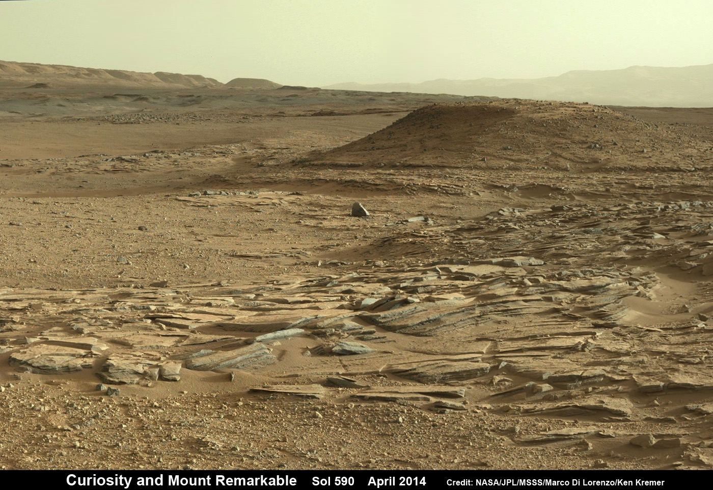
Curiosity’s Panoramic view of Mount Remarkable at ‘The Kimberley Waypoint’ where rover conducted 3rd drilling campaign inside Gale Crater on Mars. The navcam raw images were taken on Sol 603, April 17, 2014, stitched and colorized. Credit: NASA/JPL-Caltech/Ken Kremer – kenkremer.com/Marco Di Lorenzo
Featured on APOD – Astronomy Picture of the Day on May 7, 2014
The lower reaches of Mount Sharp are the rovers ultimate goal because the sedimentary layers are believed to hold caches of water altered minerals based on high resolution measurements obtained by the CRISM spectrometer aboard NASA’s powerful Martian ‘Spysat’ – the Mars Reconnaissance Orbiter (MRO) – soaring overhead.
Curiosity still has about another 2.4 miles (3.9 kilometers) to go to reach the entry way at a gap in the dunes at the foothills of Mount Sharp sometime later this year.
Curiosity snaps selfie at Kimberley waypoint with towering Mount Sharp backdrop on April 27, 2014 (Sol 613). Inset shows MAHLI camera image of rovers mini-drill test operation on April 29, 2014 (Sol 615) into “Windjama” rock target at Mount Remarkable butte. MAHLI color photo mosaic assembled from raw images snapped on Sol 613, April 27, 2014. Credit: NASA/JPL/MSSS/Marco Di Lorenzo/Ken Kremer – kenkremer.com
To date, Curiosity’s odometer totals over 4.9 miles (7.9 kilometers) since landing inside Gale Crater on Mars in August 2012. She has taken over 159,000 images.
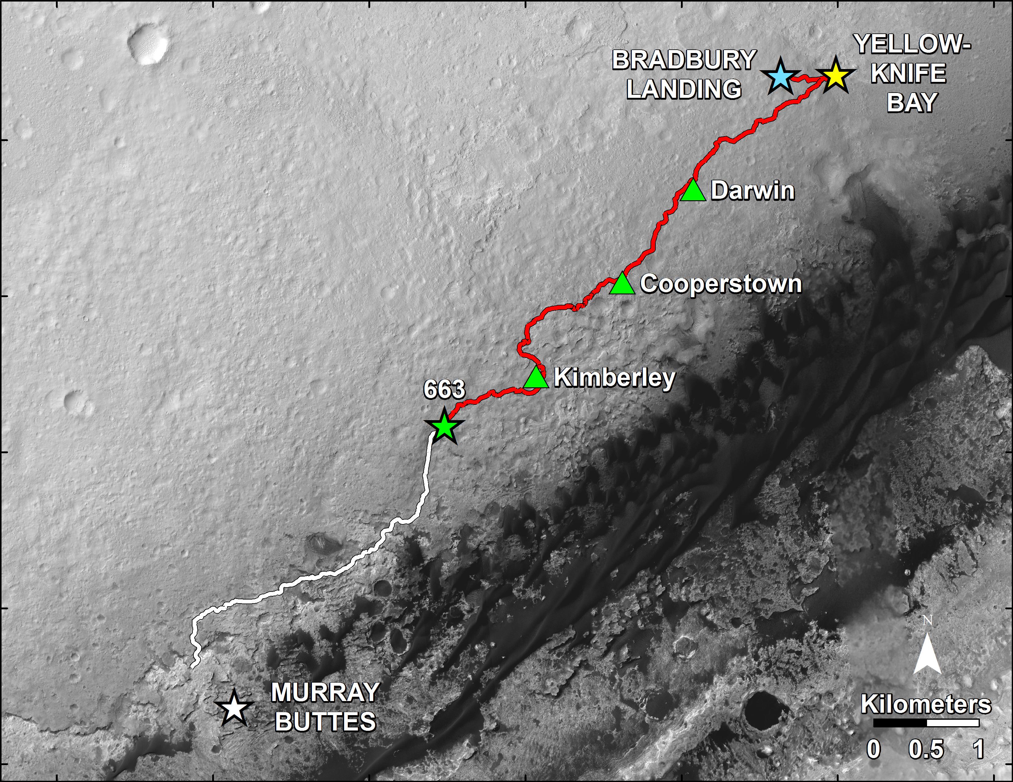
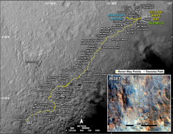
This map shows in red the route driven by NASA’s Curiosity Mars rover from the “Bradbury Landing” location where it landed in August 2012 (blue star at upper right) to nearly the completion of its first Martian year. The white line shows the planned route ahead. Image Credit: NASA/JPL
Stay tuned here for Ken’s continuing Curiosity, Opportunity, Orion, SpaceX, Boeing, Orbital Sciences, commercial space, MAVEN, MOM, Mars and more planetary and human spaceflight news.
Learn more about NASA’s Mars missions, upcoming sounding rocket and Orbital Sciences Antares ISS launch from NASA Wallops, VA in July and more about SpaceX, Boeing and commercial space and more at Ken’s upcoming presentations.
June 25: “Antares/Cygnus ISS Launch (July 10) and Suborbital Rocket Launch (June 26) from Virginia” & “Space mission updates”; Rodeway Inn, Chincoteague, VA, evening
NASA’s Curiosity rover trundles towards Mount Sharp (right) across the alien terrain of Mars - our Solar Systems most Earth-like planet - and leaves behind dramatic wheel tracks in her wake, with Gale crater rim visible in the distance at left. Curiosity captured this photo mosaic of her wheel tracks, mountain and crater rim on Sol 644 after departing ‘Kimberley’ drill site in mid-May 2014. Navcam raw images were stitched and colorized and contrast enhanced to bring out detail. Credit: NASA/JPL-Caltech/Marco Di Lorenzo/Ken Kremer – kenkremer.com
Driving, Driving, Driving – that’s the number one priority for NASA’s rover Curiosity as she traverses across the floor of Gale Crater towards towering Mount Sharp on an expedition in search of the chemical ingredients of life that could support Martian microbes if they ever existed.
See our photo mosaics above and below showing the 1 ton rover trundling across the alien terrain of Mars – our Solar Systems most Earth-like planet and leaving behind dramatic wheel tracks in her wake.
“The top priority for MSL continues to be the traverse toward the base of Mt. Sharp,” wrote science team member Ken Herkenhoff in a mission update.
Curiosity has been on the move since mid-May after successfully completing her 3rd Martian drill campaign at a science stopping point called “The Kimberley” where she bored a fresh hole into the ‘Windjama’ rock target on May 5, Sol 621 at the base of Mount Remarkable.
“Progress has been good since leaving The Kimberley,” Herkenhoff added.
Curiosity rover panorama of Mount Sharp captured on June 6, 2014 (Sol 651) during traverse inside Gale Crater. Note rover wheel tracks at left. She will eventually ascend the mountain at the ‘Murray Buttes’ at right later this year. Assembled from Mastcam color camera raw images and stitched by Marco Di Lorenzo and Ken Kremer. Credit: NASA/JPL/MSSS/Marco Di Lorenzo/Ken Kremer-kenkremer.com
The lower reaches of Mount Sharp are the rovers ultimate goal because the sedimentary layers are believed to hold caches of water altered minerals based on high resolution measurements obtained by the CRISM spectrometer aboard NASA’s powerful Martian ‘Spysat’ – the Mars Reconnaissance Orbiter (MRO) – soaring overhead.
Investigating mysterious Mount Sharp is why Gale Crater was chosen as the landing site because the mountain holds clues to the habitability of the Red Planet.
Mars was far wetter and warmer – and more conducive to the origin of life – billions of years ago.
The six-wheeled rover has been traveling with all deliberate speed to get to the mountain with minimal science along the way.
“[Curiosity conducted] a 129-meter drive on Sol 662 (June 17),” says Herkenhoff.
“We successfully planned a rapid traverse sol last week, in which scientific observations are limited in favor of maximizing drive distance.”
Curiosity is driving on a path towards the ‘Murray Buttes’ – which lies across the dark and potentially treacherous dunes on the right side of Mount Sharp as seen in our photo mosaic above from Sol 651.
She will eventually ascend the mountain at the ‘Murray Buttes’ after the team locates a spot to carefully cross the sand dunes.
The fresh hole drilled into “Windjana” was 0.63 inch (1.6 centimeters) in diameter and about 2.6 inches (6.5 centimeters) deep and resulted in a mound of dark grey colored drill tailings piled around. It looked different from the initial two holes drilled at Yellowknife Bay in the spring of 2013.
Windjana was a cold red slab of enticing bumpy textures of Martian sandstone located at the base of ‘Mount Remarkable’ within the “The Kimberley Waypoint” region.
Composite photo mosaic shows deployment of NASA Curiosity rovers robotic arm and two holes after drilling into ‘Windjana’ sandstone rock on May 5, 2014, Sol 621, at Mount Remarkable as missions third drill target for sample analysis by rover’s chemistry labs. The navcam raw images were stitched together from several Martian days up to Sol 621, May 5, 2014 and colorized. Credit: NASA/JPL-Caltech/Ken Kremer – kenkremer.com/Marco Di Lorenzo
The first two drill campaigns involved boring into mudstone outcrops at Yellowknife Bay.
Windjana lies some 2.5 miles (4 kilometers) southwest of Yellowknife Bay.
Curiosity then successfully delivered pulverized and sieved samples to the pair of onboard miniaturized chemistry labs; the Chemistry and Mineralogy instrument (CheMin) and the Sample Analysis at Mars instrument (SAM) – for chemical and compositional analysis.
Chemical analysis and further sample deliveries are in progress as NASA’s rover is ‘on the go’ to simultaneously maximize movement and research activities.
The science and engineering team has deliberately altered the robots path towards the foothills of Mount Sharp which reaches 3.4 miles (5.5 km) into the Martian sky – taller than Mount Ranier.
The team decided to follow a new path to the mountain with smoother terrain after sharp edged rocks caused significant damage in the form of dents and holes to the robots 20 inch wide aluminum wheels.
The wheel punctures happened faster than expected in 2013 and earlier this year.
Curiosity still has about another 2.4 miles (3.9 kilometers) to go to reach the entry way at a gap in the dunes at the foothills of Mount Sharp sometime later this year.
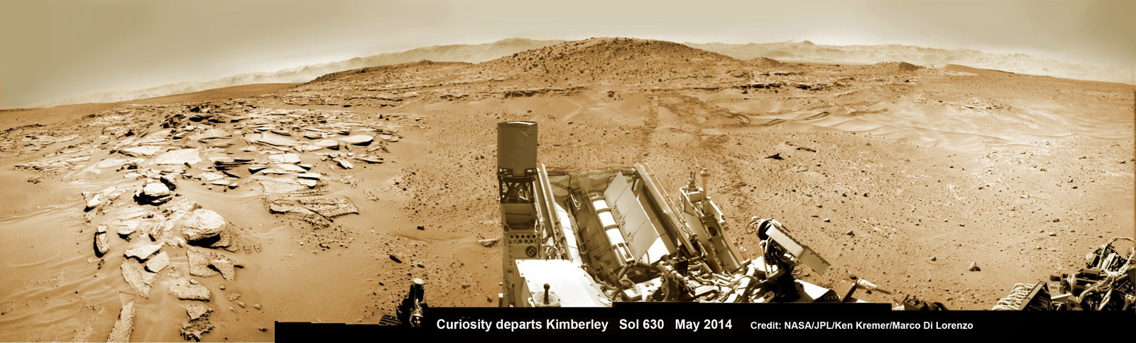
Curiosity’s panoramic view departing Mount Remarkable and ‘The Kimberley Waypoint’ where rover conducted 3rd drilling campaign inside Gale Crater on Mars. The navcam raw images were taken on Sol 630, May 15, 2014, stitched and colorized. Credit: NASA/JPL-Caltech/Ken Kremer – kenkremer.com/Marco Di Lorenzo
To date, Curiosity’s odometer totals over 7.9 kilometers (4.9 miles) since landing inside Gale Crater on Mars in August 2012. She has taken over 159,000 images.
Stay tuned here for Ken’s continuing Curiosity, Opportunity, Orion, SpaceX, Boeing, Orbital Sciences, commercial space, MAVEN, MOM, Mars and more planetary and human spaceflight news.
Curiosity’s Panoramic view of Mount Remarkable at ‘The Kimberley Waypoint’ where rover conducted 3rd drilling campaign inside Gale Crater on Mars. The navcam raw images were taken on Sol 603, April 17, 2014, stitched and colorized. Credit: NASA/JPL-Caltech/Ken Kremer – kenkremer.com/Marco Di Lorenzo.
Featured on APOD – Astronomy Picture of the Day on May 7, 2014 Curiosity Route Map. Credit: NASA/JPL
…………….
Learn more about NASA’s Mars missions, upcoming sounding rocket and Orbital Sciences Antares ISS launch from NASA Wallops, VA in July and more about SpaceX, Boeing and commercial space and more at Ken’s upcoming presentations
June 25: “Antares/Cygnus ISS Launch (July 10) and Suborbital Rocket Launch (June 26) from Virginia” & “Space mission updates”; Rodeway Inn, Chincoteague, VA, evening
India’s Mars Orbiter Mission (MOM) marked 100 days out from Mars on June 16, 2014 and the Mars Orbit Insertion engine firing when it arrives at the Red Planet on September 24, 2014 after its 10 month interplanetary journey. Credit ISRO
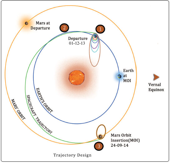
India’s inaugural voyager to the Red Planet, the Mars Orbiter Mission or MOM, has just celebrated 100 days and 100 million kilometers out from Mars on June 16, until the crucial Mars Orbital Insertion (MOI) engine firing that will culminate in a historic rendezvous on September 24, 2014.
MOM is cruising right behind NASA’s MAVEN orbiter which celebrated 100 days out from Mars on Friday the 13th of June. MAVEN arrives about 48 hours ahead of MOM on September 21, 2014.
After streaking through space for some ten and a half months, the 1,350 kilogram (2,980 pound) MOM probe will fire its 440 Newton liquid fueled main engine to brake into orbit around the Red Planet on September 24, 2014 – where she will study the atmosphere and sniff for signals of methane.
Working together, MOM and MAVEN will revolutionize our understanding of Mars atmosphere, dramatic climatic history and potential for habitability.
The do or die MOI burn on September 24, 2014 places MOM into an 377 km x 80,000 km elliptical orbit around Mars.
Trans Mars Injection (TMI), carried out on Dec 01, 2013 at 00:49 hrs (IST) has moved the spacecraft in the Mars Transfer Trajectory (MTT). With TMI the Earth orbiting phase of the spacecraft ended and the spacecraft is now on a course to encounter Mars after a journey of about 10 months around the Sun. Credit: ISRO
MOM was designed and developed by the Indian Space Research Organization’s (ISRO) at a cost of $69 Million and marks India’s maiden foray into interplanetary flight.
But before reaching Mars, mission navigators must keep the craft meticulously on course on its heliocentric trajectory from Earth to Mars through a series of in flight Trajectory Correction Maneuvers (TMSs).
The second TCM was just successfully performed on June 11 by firing the spacecraft’s 22 Newton thrusters for a duration of 16 seconds. TCM-1 was conducted on December 11, 2013 by firing the 22 Newton Thrusters for 40.5 seconds. Two additional TCM firings are planned in August and September 2014.
To date the probe has flown about 70% of the way to Mars, traveling about 466 million kilometers out of a total of 680 million kilometers (400 million miles) overall, with about 95 days to go. One way radio signals to Earth take approximately 340 seconds.
MOM reached the halfway mark to Mars on April 9, 2014.
MOM conducts Trajectory Correction Manoeuver (TCM) in Baiju Raj’s imagination.
ISRO reports the spacecraft and its five science instruments are healthy. It is being continuously monitored by the Indian Deep Space Network (IDSN) and NASA JPL’s Deep Space Network (DSN).
MOM’s journey began with a picture perfect blast off on Nov. 5, 2013 from India’s spaceport at the Satish Dhawan Space Centre, Sriharikota, atop the nations indigenous four stage Polar Satellite Launch Vehicle (PSLV) which placed the probe into its initial Earth parking orbit.
A series of six subsequent orbit raising maneuvers ultimately culminated with a liquid fueled main engine firing on Dec. 1, 2013 for the Trans Mars Injection(TMI) maneuver that successfully placed MOM on a heliocentric elliptical trajectory to the Red Planet.
If all goes well, India will join an elite club of only four who have launched probes that successfully investigated the Red Planet from orbit or the surface – following the Soviet Union, the United States and the European Space Agency (ESA).
First ever image of Earth Taken by Mars Color Camera aboard India’s Mars Orbiter Mission (MOM) spacecraft while orbiting Earth and before the Trans Mars Insertion firing on Dec. 1, 2013. Image is focused on the Indian subcontinent. Credit: ISRO
Both MAVEN and MOM’s goal is to study the Martian atmosphere, unlock the mysteries of its current atmosphere and determine how, why and when the atmosphere and liquid water was lost – and how this transformed Mars climate into its cold, desiccated state of today.
Together, MOM and MAVEN will fortify Earth’s invasion fleet at Mars. They join 3 current orbiters from NASA and ESA as well as NASA’s pair of sister surface rovers Curiosity and Opportunity.
Although they were developed independently and have different suites of scientific instruments, the MAVEN and MOM science teams will “work together” to unlock the secrets of Mars atmosphere and climate history, MAVEN’s top scientist told Universe Today.
“We have had some discussions with their science team, and there are some overlapping objectives,” Bruce Jakosky told me. Jakosky is MAVEN’s principal Investigator from the University of Colorado at Boulder.
“At the point where we [MAVEN and MOM] are both in orbit collecting data we do plan to collaborate and work together with the data jointly,” Jakosky said.
Stay tuned here for Ken’s continuing MOM, MAVEN, Opportunity, Curiosity, Mars rover and more planetary and human spaceflight news.
MAVEN – NASA’s next Red Planet orbiter – marks 100 days from Mars orbit insertion (MOI) engine firing on Friday the 13th of June 2014. MAVEN arrives at Mars on September 21, 2014. Credit: NASA
…………….
Learn more about NASA’s Mars missions, upcoming sounding rocket and Orbital Sciences Antares ISS launch from NASA Wallops, VA in July and more about SpaceX, Boeing and commercial space and more at Ken’s upcoming presentations.
June 25: “Antares/Cygnus ISS Launch (July 10) and Suborbital Rocket Launch (June 26) from Virginia” & “Space mission updates”; Rodeway Inn, Chincoteague, VA, evening
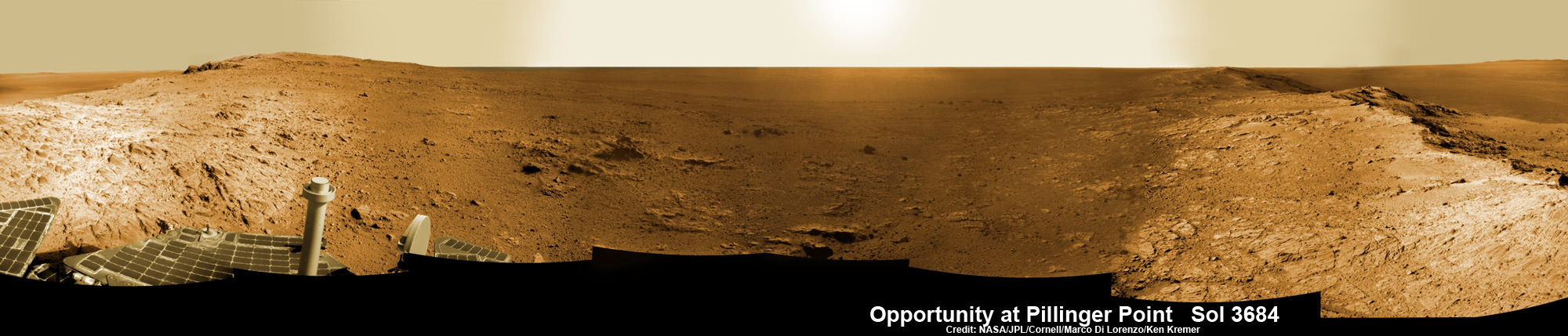
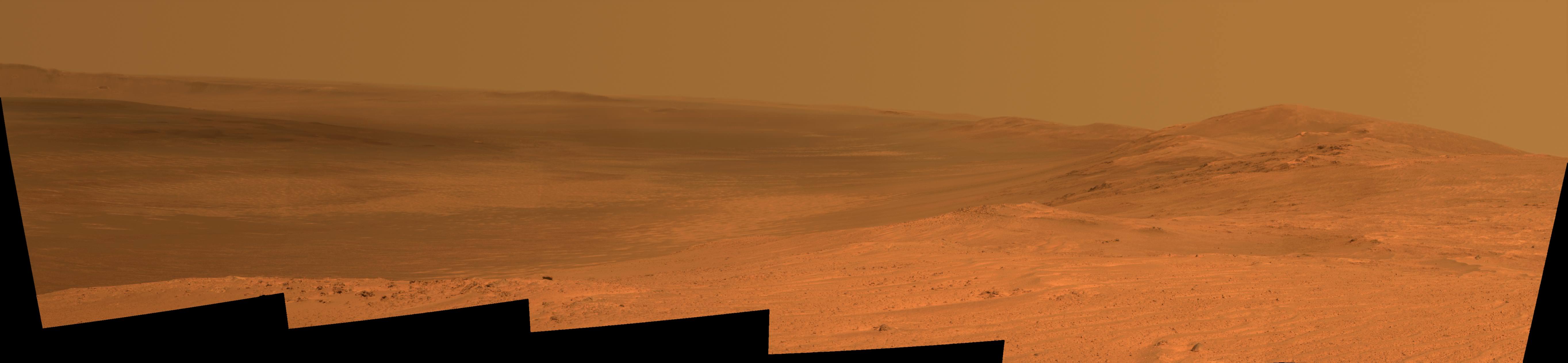
Opportunity Mars rover peers into vast Endeavour Crater from Pillinger Point mountain ridge named in honor of Colin Pillinger, the Principal Investigator for the British Beagle 2 lander built to search for life on Mars. Pillinger passed away from a brain hemorrhage on May 7, 2014. This navcam camera photo mosaic was assembled from images taken on June 5, 2014 (Sol 3684) and colorized. Credit: NASA/JPL/Cornell/Marco Di Lorenzo/Ken Kremer-kenkremer.com
NASA’s decade old Opportunity rover has reached a long sought after region of aluminum-rich clay mineral outcrops at a new Endeavour crater ridge now “named ‘Pillinger Point’ after Colin Pillinger the Principal Investigator for the [British] Beagle 2 Mars lander”, Prof. Ray Arvidson, Deputy Principal Investigator for the rover, told Universe Today exclusively. See above the spectacular panoramic view from ‘Pillinger Point’ – where ancient water once flowed billions of year ago.
The Beagle 2 lander was built to search for signs of life on Mars.
The Mars Exploration Rover (MER) team named the noteworthy ridge in honor of Prof. Colin Pillinger – a British planetary scientist at the Open University in Milton Keynes, who passed away at the age of 70 on May 7, 2014.
‘Pillinger Point’ is a scientifically bountiful place possessing both clay mineral outcrops and mineral veins where “waters came up through the cracks”, Arvidson explained to me.
Since water is a prerequisite for life as we know it, this is a truly fitting tribute to name Opportunity’s current exploration site ‘Pillinger Point’ after Prof. Pillinger.
See our new photo mosaic above captured by Opportunity peering out from ‘Pillinger Point’ ridge on June 5, 2014 (Sol 3684) and showing a panoramic view around the eroded mountain ridge and into vast Endeavour crater.
The gigantic crater spans 14 miles (22 kilometers) in diameter.
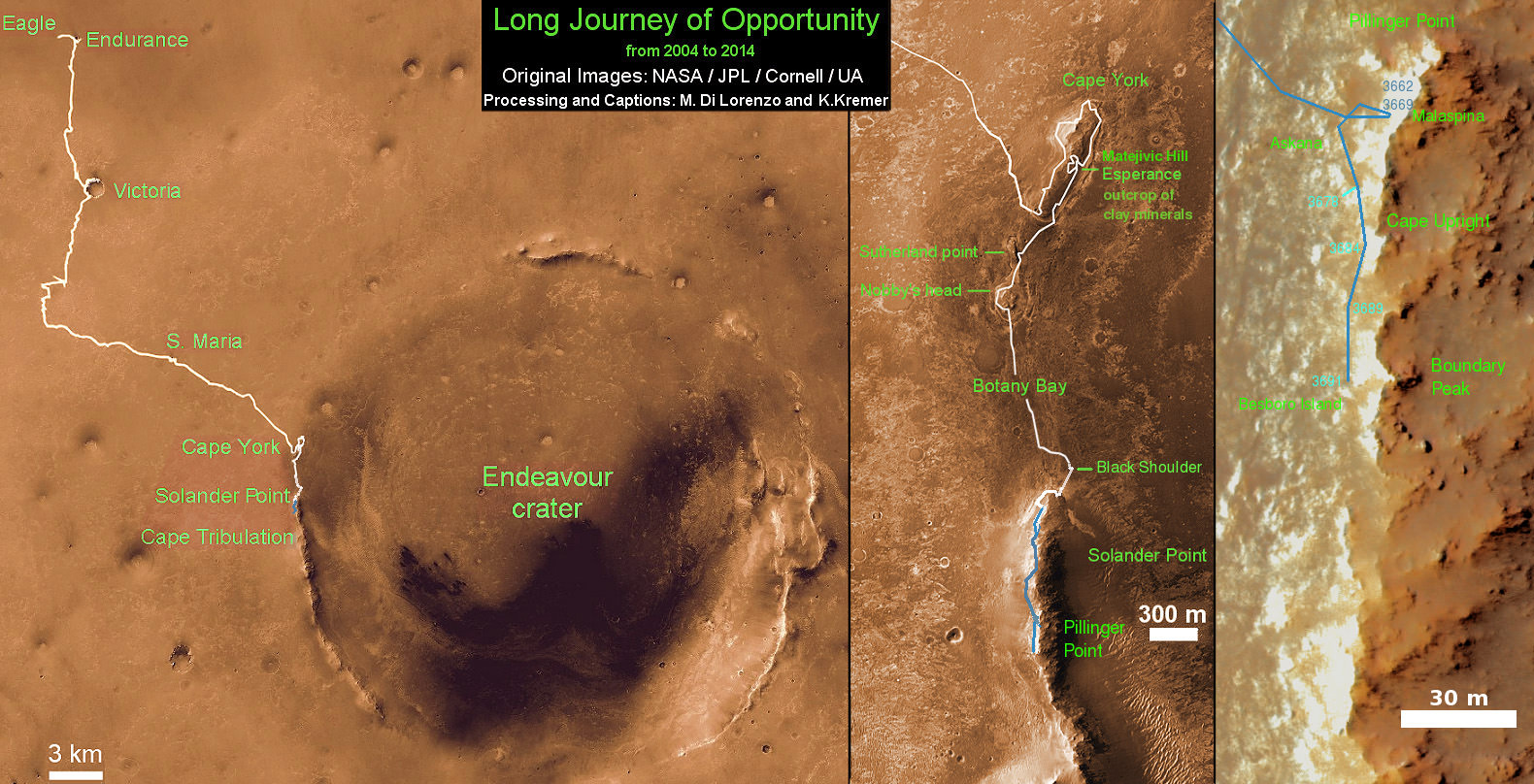
See below our Opportunity 10 Year traverse map showing the location of Pillinger Point along the segmented rim of Endeavour crater.
British planetary scientist Colin Pillinger with the Beagle 2 lander.
Pillinger Point is situated south of Solander Point and Murray Ridge along the western rim of Endeavour in a region with caches of clay minerals indicative of an ancient Martian habitable zone.
For the past several months, the six wheeled robot has been trekking southwards from Solander towards the exposures of aluminum-rich clays – now named Pillinger Point- detected from orbit by the CRISM spectrometer aboard NASA’s powerful Martian ‘Spysat’ – the Mars Reconnaissance Orbiter (MRO) – while gathering context data at rock outcrops along the winding way.
“We are about 3/5 of the way along the outcrops that show an Al-OH [aluminum-hydroxl] montmorillonite [clay mineral] signature at 2.2 micrometers from CRISM along track oversampled data,” Arvidson told me.
“We have another ~160 meters to go before reaching a break in the outcrops and a broad valley.”
The rover mission scientists ultimate goal is travel even further south to ‘Cape Tribulation’ which holds a motherlode of the ‘phyllosilicate’ clay minerals based on extensive CRISM measurements accomplished earlier at Arvidson’s direction.
“The idea is to characterize the outcrops as we go and then once we reach the valley travel quickly to Cape Tribulation and the smectite valley, which is still ~2 km to the south of the present rover location,” Arvidson explained.
Mars Express and Beagle 2 were launched in 2003, the same year as NASA’s twin rovers Spirit and Opportunity, on their interplanetary voyages to help unlock the mysteries of Mars potential for supporting microbial life forms.
Pillinger was the driving force behind the British built Beagle 2 lander which flew to the Red Planet piggybacked on ESA’s Mars Express orbiter. Unfortunately Beagle 2 vanished without a trace after being deployed from the orbiter on Dec. 19, 2003 with an expected air bag assisted landing on Christmas Day, Dec. 25, 2003.
In an obituary by the BBC, Dr David Parker, the chief executive of the UK Space Agency, said that Prof. Pillinger had played a critical role in raising the profile of the British space programme and had inspired “young people to dream big dreams”.
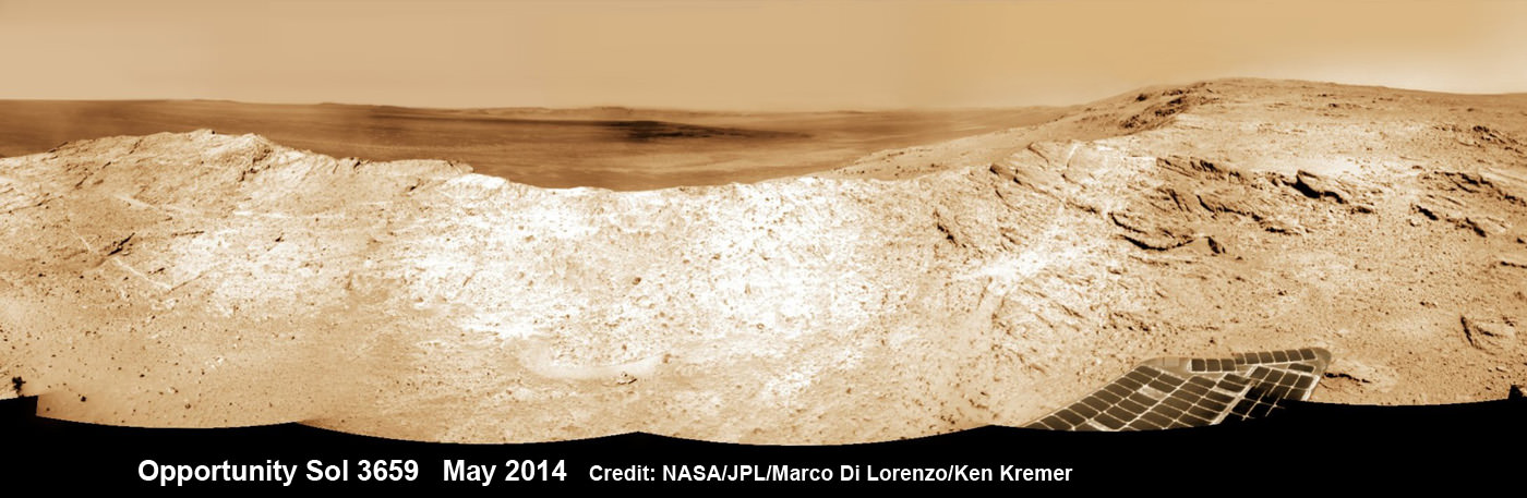
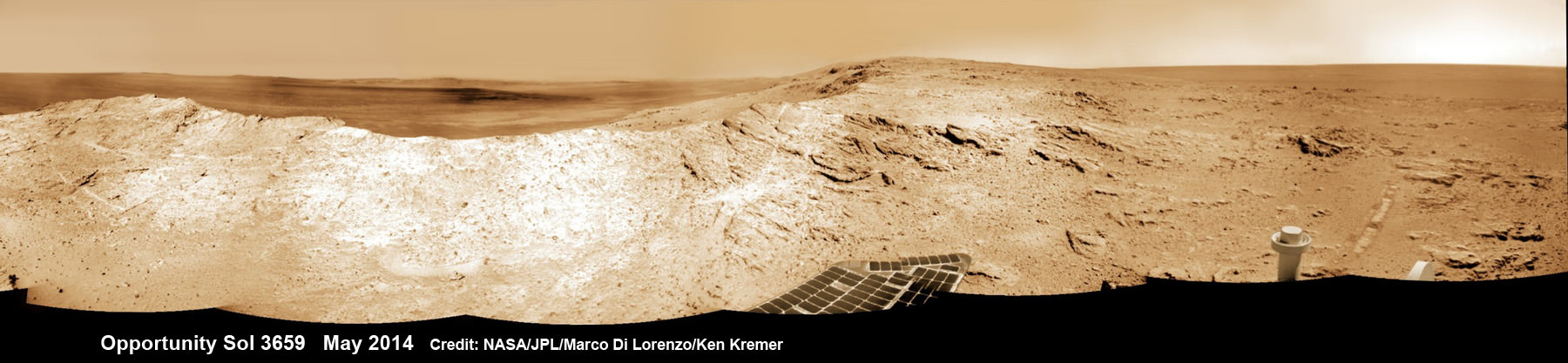
NASA’s Opportunity Mars rover captures sweeping panoramic vista near the ridgeline of 22 km (14 mi) wide Endeavour Crater’s western rim. The center is southeastward and also clearly shows the distant rim. See the complete panorama below. This navcam panorama was stitched from images taken on May 10, 2014 (Sol 3659) and colorized. Credit: NASA/JPL/Cornell/Marco Di Lorenzo/Ken Kremer-kenkremer.com
During his distinguished career Pillinger also analyzed lunar rock samples from NASA’s Apollo moon landing missions and worked on ESA’s Rosetta mission.
“It’s important to note that Colin’s contribution to planetary science goes back to working on Moon samples from Apollo, as well as his work on meteorites,” Dr Parker told the BBC.
Today, June 16, marks Opportunity’s 3696th Sol or Martian Day roving Mars – compared to a warranty of just 90 Sols.
So far she has snapped over 193,400 amazing images on the first overland expedition across the Red Planet.
Her total odometry stands at over 24.51 miles (39.44 kilometers) since touchdown on Jan. 24, 2004 at Meridiani Planum.
NASA’s Opportunity Mars rover captures sweeping panoramic vista near the ridgeline of 22 km (14 mi) wide Endeavour Crater’s western rim. The center is southeastward and the distant rim is visible in the center. An outcrop area targeted for the rover to study is at right of ridge. This navcam panorama was stitched from images taken on May 10, 2014 (Sol 3659) and colorized. Credit: NASA/JPL/Cornell/Marco Di Lorenzo/Ken Kremer-kenkremer.com
Meanwhile on the opposite side of Mars, Opportunity’s younger sister rover Curiosity is trekking towards gigantic Mount Sharp after drilling into her 3rd Red Planet rock at Kimberley.
Stay tuned here for Ken’s continuing Curiosity, Opportunity, Orion, SpaceX, Boeing, Orbital Sciences, MAVEN, MOM, Mars and more planetary and human spaceflight news.
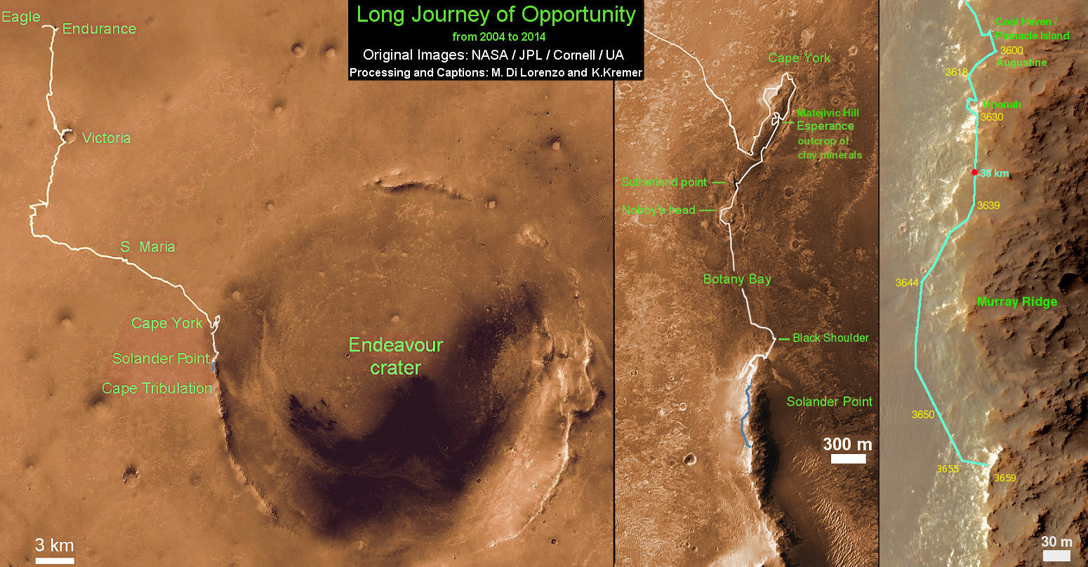
Traverse Map for NASA’s Opportunity rover from 2004 to 2014 – A Decade on Mars
This map shows the entire path the rover has driven during a decade on Mars and over 3692 Sols, or Martian days, since landing inside Eagle Crater on Jan 24, 2004 to current location along Pillinger Point ridge south of Solander Point summit at the western rim of Endeavour Crater and heading to clay minerals at Cape Tribulation. Opportunity discovered clay minerals at Esperance – indicative of a habitable zone. Credit: NASA/JPL/Cornell/ASU/Marco Di Lorenzo/Ken Kremer
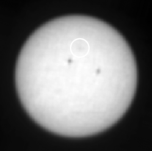
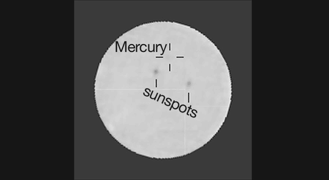
Image of the Sun as seen from Mars by Curiosity. Mercury is the circled dark spot.
NASA’s Curiosity rover may be busy exploring the rugged and rocky interior of Gale Crater, but it does get a chance to skygaze on occasion. And while looking at the Sun on June 3, 2014 (mission Sol 649) the rover’s Mastcam spotted another member of our Solar System: tiny Mercury, flitting across the Sun’s face.
Silhouetted against the bright disk of the Sun, Mercury barely appears as a hazy blur in the filtered Mastcam images. But it was moving relatively quickly during the transit, passing the darker smudges of two Earth-sized sunspots over the course of several hours.
It’s the first time Mercury has ever been imaged from Mars, and also the first time we’ve observed a planet transiting our Sun from another world besides our own.
Watch an animation of the transit below:
Animated 1-hour interval blink comparison showing Mercury’s movement across the Sun
Because the sunspots move along with the rotation of the Sun (and the Sun rotates once avery 25 days around its equator) Mercury makes a fast pass as it travels along on one of its 88-day-long years.
In reality this was no chance spotting, but rather a carefully calculated observation using the Mastcam’s right 100mm telephoto lens and neutral density filter, which is used to routinely image the Sun in order to measure the dustiness of the Martian atmosphere.
“This is a nod to the relevance of planetary transits to the history of astronomy on Earth. Observations of Venus transits were used to measure the size of the solar system, and Mercury transits were used to measure the size of the sun.”
– Mark Lemmon, Texas A&M University, member of the Mastcan science team
The next chance for Curiosity to spot Mercury will come in April 2015 and, if the rover is still operating by then — perhaps with some upgrades by future human visitors? — it may capture Earth similarly passing across the Sun in November of 2084.
Curiosity rover panorama of Mount Sharp captured on June 6, 2014 (Sol 651) during traverse inside Gale Crater. Note rover wheel tracks at left. She will eventually ascend the mountain at the ‘Murray Buttes’ at right later this year. Assembled from Mastcam color camera raw images and stitched by Marco Di Lorenzo and Ken Kremer. Credit: NASA/JPL/MSSS/Marco Di Lorenzo/Ken Kremer-kenkremer.com
Curiosity rover panorama of Mount Sharp captured on June 6, 2014 (Sol 651) during traverse inside Gale Crater. Note rover wheel tracks at left. She will eventually ascend the mountain at the ‘Murray Buttes’ at right later this year. Assembled from Mastcam color camera raw images and stitched by Marco Di Lorenzo and Ken Kremer. Credit: NASA/JPL/MSSS/Marco Di Lorenzo/Ken Kremer-kenkremer.com Story updated[/caption]
Within the past Martian day on Friday, June 6, NASA’s rover Curiosity captured a stunning new panorama of towering Mount Sharp and the treacherous sand dunes below which she must safely traverse before reaching the mountains foothills – while ‘On The Go’ to her primary destination.
See our brand new Mount Sharp photo mosaic above – taken coincidentally by humanity’s emissary on Mars on the 70th anniversary of D-Day on Earth.
Basically she’s eating desiccated dirt while running a Martian marathon.
Having said ‘Goodbye Kimberley’ after drilling her third bore hole deep into a cold red slab of enticing bumpy textures of Martian sandstone in the name of science, our intrepid mega rover Curiosity is trundling along with all deliberate speed towards the inviting slopes of sedimentary rocks at the base of mysterious Mount Sharp which hold clues to the habitability of the Red Planet.
The sedimentary layers of Mount Sharp, which reaches 3.4 miles (5.5 km) into the Martian sky, is the six wheeled robots ultimate destination inside Gale Crater because it holds caches of water altered minerals.
Such minerals could possibly mark locations that sustained potential Martian microbial life forms, past or present, if they ever existed.
Mars was far wetter and warmer – and more conducive to the origin of life – billions of years ago.
Curiosity’s panoramic view departing Mount Remarkable and ‘The Kimberley Waypoint’ where rover conducted 3rd drilling campaign inside Gale Crater on Mars. The navcam raw images were taken on Sol 630, May 15, 2014, stitched and colorized. Credit: NASA/JPL-Caltech/Ken Kremer – kenkremer.com/Marco Di Lorenzo
The 1 ton robot is driving on a path towards the Murray Buttes which lies across the dunes on the right side of Mount Sharp as seen in our photo mosaic above, with wheel tracks on the left side.
She will eventually ascend the mountain at the ‘Murray Buttes’ after crossing the sand dunes.
Curiosity still has roughly another 4 kilometers of driving to go to reach the foothills of Mount Sharp sometime later this year.
Approximately four weeks ago, Curiosity successfully completed her 3rd drilling campaign since landing at the science waypoint region called “The Kimberley” on May 5, Sol 621, into the ‘Windjana’ rock target at the base of a 16 foot tall ( 5 Meter) hill called Mount Remarkable.
Composite photo mosaic shows deployment of NASA Curiosity rovers robotic arm and two holes after drilling into ‘Windjana’ sandstone rock on May 5, 2014, Sol 621, at Mount Remarkable as missions third drill target for sample analysis by rover’s chemistry labs. The navcam raw images were stitched together from several Martian days up to Sol 621, May 5, 2014 and colorized. Credit: NASA/JPL-Caltech/Ken Kremer – kenkremer.com/Marco Di Lorenzo
The fresh hole drilled into “Windjana” was 0.63 inch (1.6 centimeters) in diameter and about 2.6 inches (6.5 centimeters) deep and resulted in a mound of dark grey colored drill tailings piled around. It looked different from the initial holes drilled at Yellowknife Bay in the spring of 2013.
Windjana lies some 2.5 miles (4 kilometers) southwest of Yellowknife Bay.
Curiosity then successfully delivered pulverized and sieved samples to the pair of onboard miniaturized chemistry labs; the Chemistry and Mineralogy instrument (CheMin) and the Sample Analysis at Mars instrument (SAM) – for chemical and compositional analysis.
Before departing, Curiosity blasted the hole multiple times with her million watt laser on the Mast mounted Chemistry and Camera (ChemCam) instrument , leaving no doubt of her capabilities or intentions.
And she completed an up close examination of the texture and composition of ‘Windjana’ with the MAHLI camera and spectrometers at the end of her 7-foot-long (2 meter) arm to glean every last drop of science before moving on.
“Windjana” is named after a gorge in Western Australia.
While ‘On the Go’ to Mount Sharp, the rover is keeping busy with science activities by investigating the newly cored Martian material.
“Inside Curiosity we continue to analyse the Kimberley samples with CheMin and SAM,” wrote mission team member John Bridges in an update.
To date, Curiosity’s odometer totals 3.8 miles (6.1 kilometers) since landing inside Gale Crater on Mars in August 2012. She has taken over 154,000 images.
Stay tuned here for Ken’s continuing Curiosity, Opportunity, Orion, SpaceX, Boeing, Orbital Sciences, commercial space, MAVEN, MOM, Mars and more planetary and human spaceflight news.
Curiosity’s Panoramic view of Mount Remarkable at ‘The Kimberley Waypoint’ where rover conducted 3rd drilling campaign inside Gale Crater on Mars. The navcam raw images were taken on Sol 603, April 17, 2014, stitched and colorized. Credit: NASA/JPL-Caltech/Ken Kremer – kenkremer.com/Marco Di Lorenzo
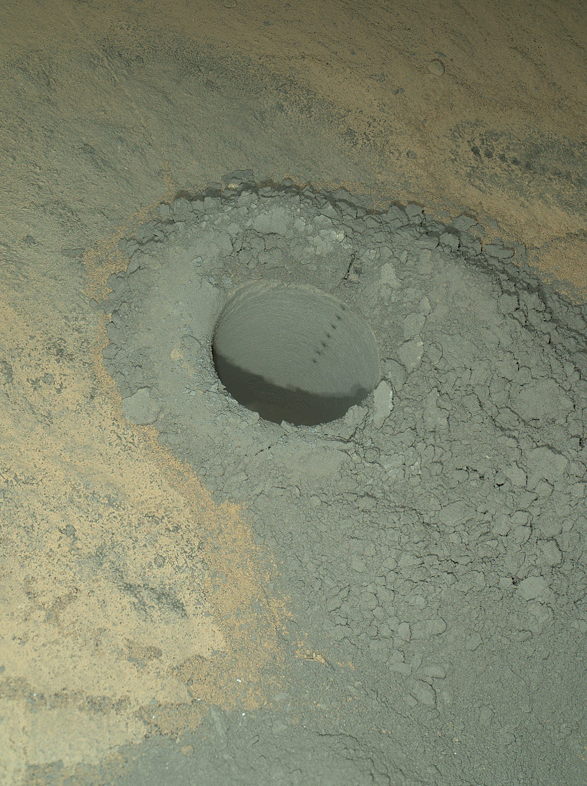
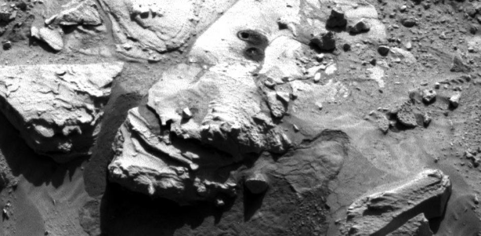
Featured on APOD – Astronomy Picture of the Day on May 7, 2014 The Mars Hand Lens Imager on NASA’s Curiosity Mars rover provided this nighttime view of a hole produced by the rover’s drill and, inside the hole, a line of scars produced by the rover’s rock-zapping laser. The hole is 0.63 inch (1.6 centimeters) in diameter. The camera used its own white-light LEDs to illuminate the scene on May 13, 2014. Credit: NASA/JPL-Caltech/MSSS
NASA’s Opportunity Mars rover captures sweeping panoramic vista near the ridgeline of 22 km (14 mi) wide Endeavour Crater’s western rim. The center is southeastward and also clearly shows the distant rim. See the complete panorama below. This navcam panorama was stitched from images taken on May 10, 2014 (Sol 3659) and colorized. Credit: NASA/JPL/Cornell/Marco Di Lorenzo/Ken Kremer-kenkremer.com
NASA’s Opportunity Mars rover captures sweeping panoramic vista near the ridgeline of 22 km (14 mi) wide Endeavour Crater’s western rim. The center is southeastward and also clearly shows the distant rim. See the complete panorama below. This navcam panorama was stitched from images taken on May 10, 2014 (Sol 3659) and colorized. Credit: NASA/JPL/Cornell/Marco Di Lorenzo/Ken Kremer-kenkremer.com
More mosaics and 10 year route map below[/caption]
NASA’s incredibly long lived Opportunity rover has driven to the ridgeline of a Martian mountain and captured spectacular panoramic vistas peering down into the vast expanse of huge Endeavour crater and out along the jagged rim segments leading to her next target – which scientists believe holds minerals indicative of a habitable zone. See mosaic views above and below.
Since departing the world famous ‘Jelly Doughnut’ rock by the summit of ‘Solander Point’ in February, Opportunity has spent the past several months driving south and exploring intriguing rock outcrops on ‘Murray Ridge’ located along the eroded western rim of Endeavour Crater.
The renowned robot is now exploring a region of outcrops atop the rims ridge that’s a possible site harboring deposits of hydrated clay minerals, formed in the ancient past when Mars was warmer and wetter.
The ten year oldRed Planet rover first reached the rim of Endeavour Crater in August 2011. She has captured numerous sweeping gorgeous vistas during her first of its kind expedition on the surface of another planet by an alien probe from Earth.
Read my earlier story detailing the top 10 discoveries from twin sisters Spirit and Opportunity according to Deputy Principal Investigator Prof. Ray Arvidson – here.
The gigantic crater spans 14 miles (22 kilometers) in diameter.
So there is endless enthralling terrain to investigate – for at least another 10 years!
The floor of Endeavour crater is filled with dark sand, brighter dust, and, in the distance, dusty haze, says NASA.
This vista of the Endeavour Crater rim was acquired by NASA’s Mars Exploration Rover Opportunity’s panoramic camera on April 18, 2014, from the southern end of “Murray Ridge” on the western rim of the crater. In mid-May, the rover approached the dark outcrops on the flank of the hill at right. The high peak in the distance on the right is informally named “Cape Tribulation” and is about 1.2 miles (2 kilometers) to the south of Opportunity’s position when this view was recorded Credit: NASA/JPL-Caltech/Cornell Univ./Arizona State Univ.
Opportunity’s goal all the while has been to doggedly trek southwards towards exposures of aluminum-rich clays detected from orbit by NASA’s powerful Martian ‘Spysat’ – the Mars Reconnaissance Orbiter (MRO) – while gathering context data at rock outcrops at Murray Ridge along the winding way.
These aluminum-rich clay minerals, or phyllosilicates, likely formed billions of years ago in flowing liquid neutral water which is more conducive to life, compared to more acidic environments explored earlier in the mission, and is therefore potentially indicative of a Martian habitable zone and a scientific goldmine.
The science and engineering team has used the high resolution MRO spectral and imaging data to more efficiently direct Opportunity southwards along the Endeavour crater rim and towards the biggest caches of the clay minerals – which were detected at a mountainous rim segment called ‘Cape Tribulation’ and which is seen in the panoramic vistas.
Although Cape Tribulation still lies some 1.2 miles (2 kilometers) further south, the rover has just arrived at a region which the team believes shows the first signatures of the clay minerals.
NASA’s Opportunity Mars rover captures sweeping panoramic vista near the ridgeline of 22 km (14 mi) wide Endeavour Crater’s western rim. The center is southeastward and the distant rim is visible in the center. An outcrop area targeted for the rover to study is at right of ridge. This navcam panorama was stitched from images taken on May 10, 2014 (Sol 3659) and colorized. Credit: NASA/JPL/Cornell/Marco Di Lorenzo/Ken Kremer-kenkremer.com
“The rover is exploring the region of aluminum-hydroxyl clay minerals seen from orbit,” said NASA in a mission update.
The six wheeled robot will utilize her mast mounted cameras and arm mounted microscopic imager (MI) and APXS spectrometer to gather images and measurements to unlock the mysteries of Mars ability to support life – past or present.
“The more we explore Mars, the more interesting it becomes. These latest findings present yet another kind of gift that just happens to coincide with Opportunity’s 10th anniversary on Mars,” said Michael Meyer, lead scientist for NASA’s Mars Exploration Program.
“We’re finding more places where Mars reveals a warmer and wetter planet in its history. This gives us greater incentive to continue seeking evidence of past life on Mars.”
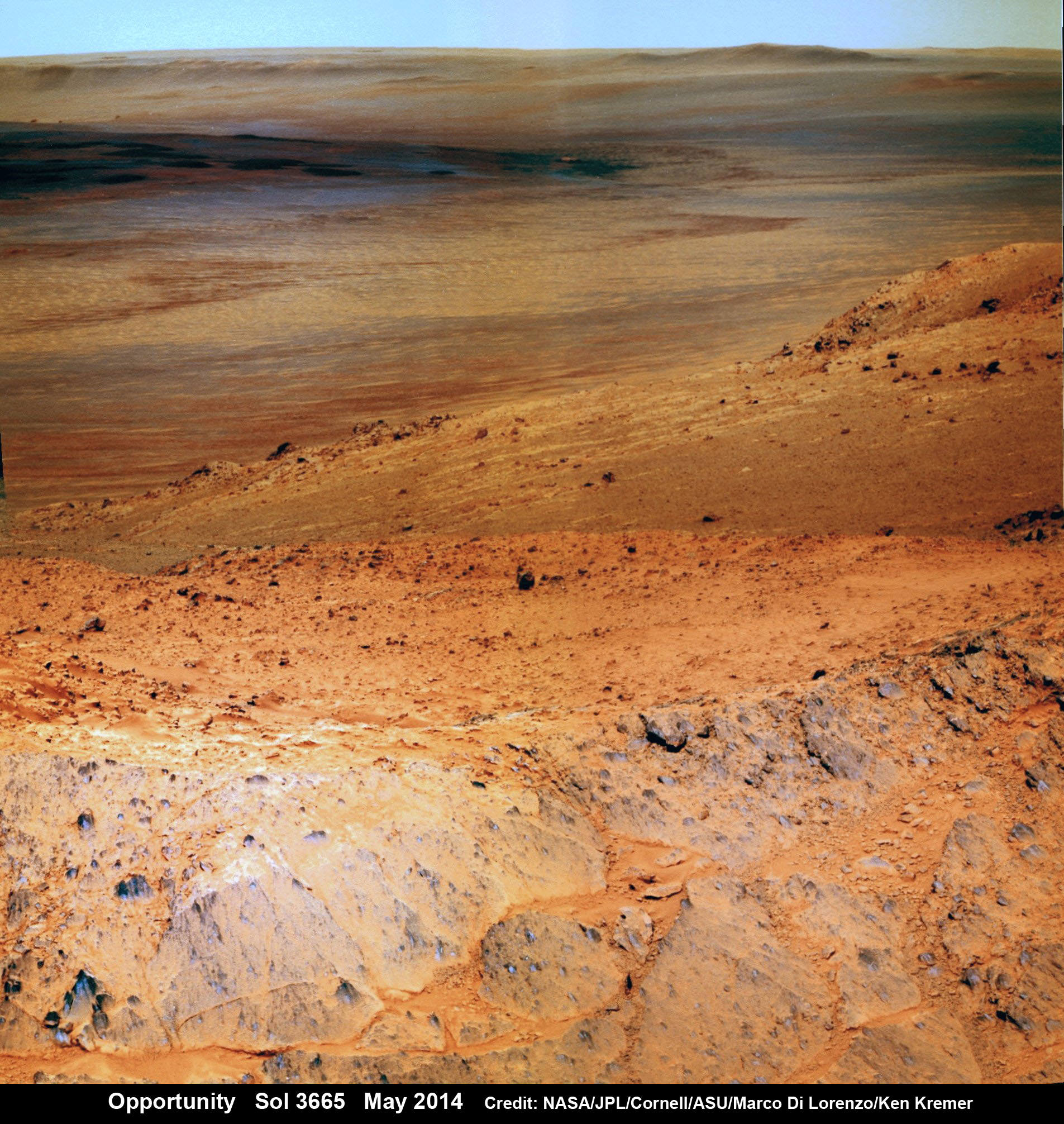
Opportunity Mars rover peers over mountain ridge for gorgeous vista into floor and out to distant rim of 22 km (14 mi) wide Endeavour Crater. This pancam camera view was assembled from images taken on May 16, 2014 (Sol 3665) with false color sky. Credit: NASA/JPL/Cornell/Marco Di Lorenzo/Ken Kremer-kenkremer.com
And Opportunity is now power-rich following a series of fortuitous wind cleaning events that substantially cleared the dust off the power generating solar wing arrays.
The solar array energy production has reached 761 watt-hours compared to about 900 watt-hours at landing in 2004 and only about 270 watt-hours just before Christmastime in December 2013.
“Solar panels [are] cleanest since about sol 1600 [September 2008],” says mission science team member Larry Crumpler.
More power means more work time and more bonus science studies and data return.
So the robot survived magnificently through her 6th harsh Martian winter with plenty of science rich targets planned ahead during the southern hemisphere Martian spring and summer.
Opportunity by Solander Point peak – 2nd Mars Decade Starts here!
NASA’s Opportunity rover captured this panoramic mosaic on Dec. 10, 2013 (Sol 3512) near the summit of “Solander Point” on the western rim of Endeavour Crater where she starts Decade 2 on the Red Planet. She is currently investigating outcrops of potential clay minerals formed in liquid water on her 1st mountain climbing adventure. Assembled from Sol 3512 navcam raw images. Credit: NASA/JPL/Cornell/Marco Di Lorenzo/Ken Kremer-kenkremer.com
Today, May 24, marks Opportunity’s 3673nd Sol or Martian Day roving Mars – compared to a warranty of just 90 Sols.
So far she has snapped over 192,600 amazing images on the first overland expedition across the Red Planet.
Her total odometry stands at over 24.49 miles (39.41 kilometers) since touchdown on Jan. 24, 2004 at Meridiani Planum.
Meanwhile on the opposite side of Mars, Opportunity’s younger sister rover Curiosity is trekking towards gigantic Mount Sharp and just drilled into her 3rd Red Planet rock at Kimberley.
Stay tuned here for Ken’s continuing Curiosity, Opportunity, Orion, SpaceX, Boeing, Orbital Sciences, MAVEN, MOM, Mars and more planetary and human spaceflight news.
Traverse Map for NASA’s Opportunity rover from 2004 to 2014 – A Decade on Mars
This map shows the entire path the rover has driven during a decade on Mars and over 3660 Sols, or Martian days, since landing inside Eagle Crater on Jan 24, 2004 to current location along Murray Ridge south of Solander Point summit at the western rim of Endeavour Crater and heading to clay minerals at Cape Tribulation. Opportunity discovered clay minerals at Esperance – indicative of a habitable zone. Credit: NASA/JPL/Cornell/ASU/Marco Di Lorenzo/Ken Kremer
The Mars Hand Lens Imager on NASA's Curiosity Mars rover provided this nighttime view of a hole produced by the rover's drill and, inside the hole, a line of scars produced by the rover's rock-zapping laser. The hole is 0.63 inch (1.6 centimeters) in diameter. The camera used its own white-light LEDs to illuminate the scene on May 13, 2014. Credit: NASA/JPL-Caltech/MSSS
NASA’s rover Curiosity said ‘Goodbye Kimberley’ having fulfilled her objectives of drilling into a cold red sandstone slab, sampling the tantalizing grey colored interior and pelting the fresh bore hole with a pinpoint series of parting laser blasts before seeking new adventures on the road ahead towards the inviting slopes of Mount Sharp, her ultimate destination.
Curiosity successfully drilled her 3rd hole deep into the ‘Windjama’ rock target at the base of Mount Remarkable and within the science waypoint at a region called “The Kimberley” on May 5, Sol 621.
Since then, the 1 ton robot carefully scrutinized the resulting 2.6 inches (6.5 centimeters) deep bore hole and the mound of dark grey colored drill tailings piled around for an up close examination of the texture and composition with the MAHLI camera and spectrometers at the end of her 7-foot-long (2 meters) arm to glean every last drop of science before moving on.
Curiosity’s panoramic view departing Mount Remarkable and ‘The Kimberley Waypoint’ where rover conducted 3rd drilling campaign inside Gale Crater on Mars. The navcam raw images were taken on Sol 630, May 15, 2014, stitched and colorized. Credit: NASA/JPL-Caltech/Ken Kremer – kenkremer.com/Marco Di Lorenzo
Multiple scars clearly visible inside the drill hole and on the Martian surface resulting from the million watt laser firings of the Mast mounted Chemistry and Camera (ChemCam) instrument left no doubt of Curiosity’s capabilities or intentions.
Furthermore she successfully delivered pulverized and sieved samples to the pair of onboard miniaturized chemistry labs; the Chemistry and Mineralogy instrument (CheMin) and the Sample Analysis at Mars instrument (SAM) – for chemical and compositional analysis.
Curiosity completed an “intensive investigation of ‘The Kimberley’, having successfully drilled, acquired and dropped samples into CheMin and SAM,” wrote science team member Ken Herkenhoff in an update.
“MAHLI has taken lots of excellent images of the drill hole, including some during the night with LEDs on, nicely showing the ChemCam LIBS spots.”
“The initial analysis of this new sample by Chemin is ongoing, requiring repeated overnight integration to build up high-quality data,” says Herkenhoff.
The rover’s earth bound handlers also decided that one drill campaign into Kimberley was enough.
So the rover will not be drilling into any other rock targets here.
Composite photo mosaic shows deployment of NASA Curiosity rovers robotic arm and two holes after drilling into ‘Windjana’ sandstone rock on May 5, 2014, Sol 621, at Mount Remarkable as missions third drill target for sample analysis by rover’s chemistry labs. The navcam raw images were stitched together from several Martian days up to Sol 621, May 5, 2014 and colorized. Credit: NASA/JPL-Caltech/Ken Kremer – kenkremer.com/Marco Di Lorenzo
And it may be a very long time before the next drilling since the guiding team of scientists and engineers wants desperately to get on and arrive at the foothills of Mount Sharp as soon as possible.
But the robot will undoubtedly be busy with further analysis of the ‘Windjana’ sample along the way, since there’s plenty of leftover sample material stored in the CHIMRA sample processing mechanism to allow future delivery of samples when the rover periodically pauses during driving.
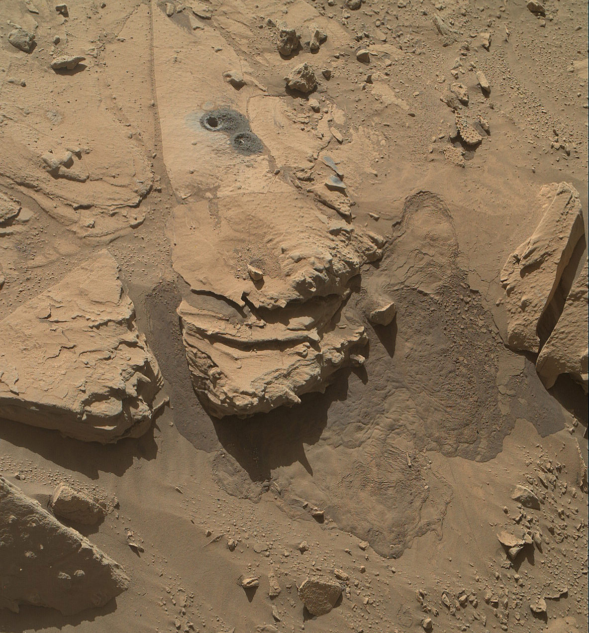
This May 12, 2014, view from the Mars Hand Lens Imager (MAHLI) in NASA’s Curiosity Mars Rover shows the rock target “Windjana” and its immediate surroundings after inspection of the site by the rover by drilling and other activities. Credit: NASA/JPL-Caltech/MSSS
“Windjana” is named after a gorge in Western Australia.
It’s been a full year since the first two drill campaigns were conducted during 2013 at the ‘John Klein’ and ‘Cumberland’ outcrop targets inside Yellowknife Bay. They were both mudstone rock outcrops and the interiors were markedly different in color.
“The drill tailings from this rock are darker-toned and less red than we saw at the two previous drill sites,” said Jim Bell of Arizona State University, Tempe, deputy principal investigator for Curiosity’s Mast Camera (Mastcam).
“This suggests that the detailed chemical and mineral analysis that will be coming from Curiosity’s other instruments could reveal different materials than we’ve seen before. We can’t wait to find out!”
The science team chose Windjana for drilling “to analyze the cementing material that holds together sand-size grains in this sandstone,” says NASA.
Curiosity’s Panoramic view of Mount Remarkable at ‘The Kimberley Waypoint’ where rover conducted 3rd drilling campaign inside Gale Crater on Mars. The navcam raw images were taken on Sol 603, April 17, 2014, stitched and colorized. Credit: NASA/JPL-Caltech/Ken Kremer – kenkremer.com/Marco Di Lorenzo
Featured on APOD – Astronomy Picture of the Day on May 7, 2014
“The Kimberley Waypoint was selected because it has interesting, complex stratigraphy,” Curiosity Principal Investigator John Grotzinger, of the California Institute of Technology, Pasadena, told me.
Curiosity departed the ancient lakebed at the Yellowknife Bay region in July 2013 where she discovered a habitable zone with the key chemical elements and a chemical energy source that could have supported microbial life billions of years ago – and thereby accomplished the primary goal of the mission.
Windjama lies some 2.5 miles (4 kilometers) southwest of Yellowknife Bay.
Curiosity still has about another 4 kilometers to go to reach the foothills of Mount Sharp sometime later this year.
The sedimentary layers of Mount Sharp, which reaches 3.4 miles (5.5 km) into the Martian sky, is the six wheeled robots ultimate destination inside Gale Crater because it holds caches of water altered minerals. Such minerals could possibly indicate locations that sustained potential Martian life forms, past or present, if they ever existed.
Stay tuned here for Ken’s continuing Curiosity, Opportunity, Orion, SpaceX, Boeing, Orbital Sciences, LADEE, MAVEN, MOM, Mars and more planetary and human spaceflight news.
Composite photo mosaic shows deployment of NASA Curiosity rovers robotic arm and two holes after drilling into ‘Windjana’ sandstone rock on May 5, 2014, Sol 621, at Mount Remarkable as missions third drill target for sample analysis by rover’s chemistry labs. The navcam raw images were stitched together from several Martian days up to Sol 621, May 5, 2014 and colorized. Credit: NASA/JPL-Caltech/Ken Kremer - kenkremer.com/Marco Di Lorenzo
Composite photo mosaic shows deployment of NASA Curiosity rovers robotic arm and two holes after drilling into ‘Windjana’ sandstone rock on May 5, 2014, Sol 621, at Mount Remarkable as missions third drill target for sample analysis by rover’s chemistry labs. The navcam raw images were stitched together from several Martian days up to Sol 621, May 5, 2014 and colorized. Credit: NASA/JPL-Caltech/Ken Kremer – kenkremer.com/Marco Di Lorenzo
See additional Curiosity mosaics below-See our APOD featured on May 7, 2014[/caption]
After a rather satisfying test bore into a sandstone slab at “Kimberley” just last week, NASA’s rover Curiosity decided to go all the way for a deep drill excursion into the Red Planet rock target called “Windjana” and successfully collected powdery samples from the interior on Monday evening, May 5, Sol 621, that the rover will soon consume inside her belly for high tech compositional analysis with her state-of-the-art science instruments.
NASA reported the great news today, Tuesday, May 6, soon after receiving confirmation of the successful acquisition effort by the hammering drill, located at the terminus of the 1 ton robots 7-foot-long (2 meter) arm.
At long last its “Drill, Baby, Drill” time on Mars.
The “Kimberley Waypoint” drill campaign into “Windjana” at the Mount Remarkable butte thus marks only the third Martian rock bored for sampling analysis by the SUV sized rover. This also counts as a new type of Mars rock – identified as sandstone, compared to the pair of mudstone rocks bored into last year.
This May 5, 2014, image (Sol 621) from the Navigation Camera on NASA’s Curiosity Mars rover shows two holes at top center drilled into a sandstone target called “Windjana.” The farther hole was created by the rover’s drill while it collected rock-powder sample material from the interior of the rock that will be fed to the rovers chemistry labs for analysis. Credit: NASA/JPL-Caltech
The fresh hole in “Windjana” created on Monday night was clearly visible in images received this afternoon and showed it was 0.63 inch (1.6 centimeters) in diameter and about 2.6 inches (6.5 centimeters) deep.
The operation went exactly as planned and left behind a residual pile of drill tailings much darker in color compared to the ubiquitous red color seen covering most of Mars surface.
The new full-depth hole is very close in proximity to the shallower “Mini-drill” test hole operation carried out on April 29 at Windjama to determine if this site met the science requirements for sampling analysis and delivery to the two onboard, miniaturized chemistry labs – SAM and CheMin.
“Windjana” is named after a gorge in Western Australia.
Curiosity’s Panoramic view of Mount Remarkable at ‘The Kimberley Waypoint’ where rover will conduct 3rd drilling campaign inside Gale Crater on Mars. The navcam raw images were taken on Sol 603, April 17, 2014, stitched and colorized. Credit: NASA/JPL-Caltech/Ken Kremer – kenkremer.com/Marco Di Lorenzo
Featured on APOD – Astronomy Picture of the Day on May 7, 2014
“The drill tailings from this rock are darker-toned and less red than we saw at the two previous drill sites,” said Jim Bell of Arizona State University, Tempe, deputy principal investigator for Curiosity’s Mast Camera (Mastcam).
“This suggests that the detailed chemical and mineral analysis that will be coming from Curiosity’s other instruments could reveal different materials than we’ve seen before. We can’t wait to find out!”
In coming days, the sample will be pulverized and sieved prior to delivery to the Chemistry and Mineralogy instrument (CheMin) and the Sample Analysis at Mars instrument (SAM) for chemical and compositional analysis.
Windjana is an outcrop of sandstone located at the base of a Martian butte named Mount Remarkable at “The “Kimberley Waypoint” – a science stopping point reached by the rover in early April 2014 halfway along its epic trek to towering Mount Sharp, the primary destination of the mission.
See herein our illustrative photo mosaics of the Kimberly Waypoint region assembled by the image processing team of Marco Di Lorenzo and Ken Kremer.
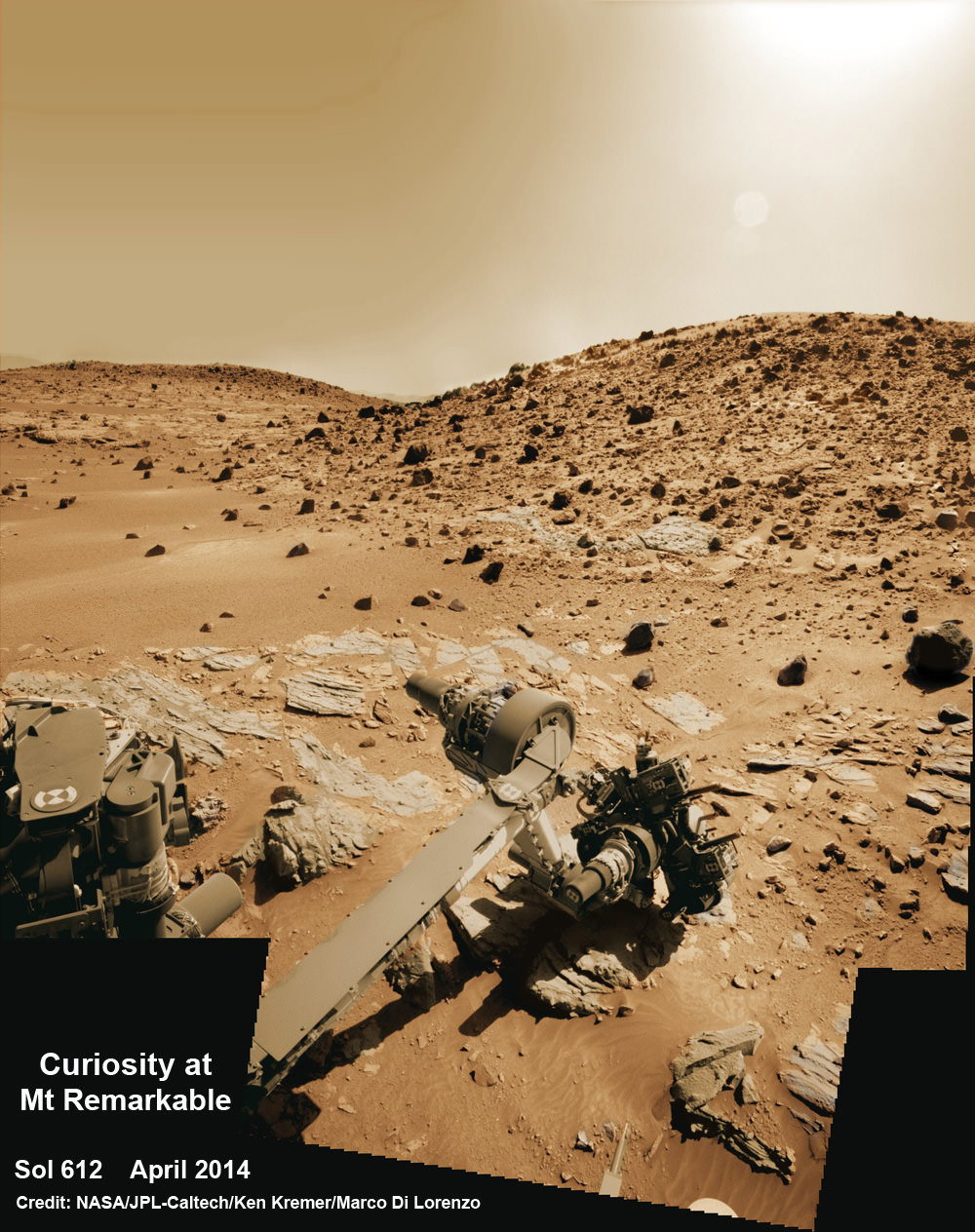
Multisol composite photo mosaic shows deployment of Curiosity’s rovers robotic arm and APXS X-ray spectrometer onto the ‘Winjana’ rock target at Mount Remarkable for evaluation as missions third drill target inside Gale Crater on Mars. The colorized navcam raw images were stitched together from several Martian days up to Sol 612, April 26, 2014. Credit: NASA/JPL-Caltech/Ken Kremer – kenkremer.com/Marco Di Lorenzo
The first two drill campaigns conducted during 2013 at ‘John Klein’ and ‘Cumberland’ inside Yellowknife Bay were on mudstone rock outcrops.
The science team chose Windjana for drilling “to analyze the cementing material that holds together sand-size grains in this sandstone,” says NASA.
“The Kimberley Waypoint was selected because it has interesting, complex stratigraphy,” Curiosity Principal Investigator John Grotzinger, of the California Institute of Technology, Pasadena, told me.
Curiosity snaps selfie at Kimberley waypoint with towering Mount Sharp backdrop on April 27, 2014 (Sol 613). Inset shows MAHLI camera image of rovers mini-drill test operation on April 29, 2014 (Sol 615) into “Windjana” rock target at Mount Remarkable butte. MAHLI color photo mosaic assembled from raw images snapped on Sol 613, April 27, 2014. Credit: NASA/JPL/MSSS/Marco Di Lorenzo/Ken Kremer – kenkremer.com
Curiosity departed the ancient lakebed at the Yellowknife Bay region in July 2013 where she discovered a habitable zone with the key chemical elements and a chemical energy source that could have supported microbial life billions of years ago – and thereby accomplished the primary goal of the mission.
Windjama is about 2.5 miles (4 kilometers) southwest of Yellowknife Bay.
Curiosity still has about another 4 kilometers to go to reach the base of Mount Sharp sometime later this year.
Martian landscape with rows of curved rock outcrops at ‘Kimberly’ in the foreground and spectacular Mount Sharp on the horizon. NASA’s Curiosity Mars rover pulled into Kimberly waypoint dominated by layered rock outcrops as likely drilling site. This colorized navcam camera photomosaic was assembled from imagery taken on Sol 576 (Mar. 20, 2014). Credit: NASA/JPL-Caltech/Marco Di Lorenzo/Ken Kremer-kenkremer.com
The sedimentary foothills of Mount Sharp, which reaches 3.4 miles (5.5 km) into the Martian sky, is the 1 ton robots ultimate destination inside Gale Crater because it holds caches of water altered minerals. Such minerals could possibly indicate locations that sustained potential Martian life forms, past or present, if they ever existed.
Stay tuned here for Ken’s continuing Curiosity, Opportunity, Chang’e-3, SpaceX, Orbital Sciences, LADEE, MAVEN, MOM, Mars and more planetary and human spaceflight news.
Curiosity scans scientifically intriguing rock outcrops of gorgeous Martian terrain at ‘The Kimberley’ waypoint in search of next drilling location beside Mount Remarkable butte, at right. Mastcam color photo mosaic assembled from raw images snapped on Sol 590, April 4, 2014. Credit: NASA/JPL/MSSS/Marco Di Lorenzo/Ken Kremer – kenkremer.com