SOFIA in flight, with its telescope exposed. Image: NASA/Jim Ross
Finding atomic oxygen in the Martian atmosphere is very difficult to do, which explains why it’s been 40 years since it was last detected. In the 1970’s, NASA’s Viking and Mariner missions detected Martian atmospheric oxygen, and now, the Stratospheric Observatory for Infrared Astronomy (SOFIA) has detected atomic oxygen in the upper portion of the Martian atmosphere called the mesosphere.
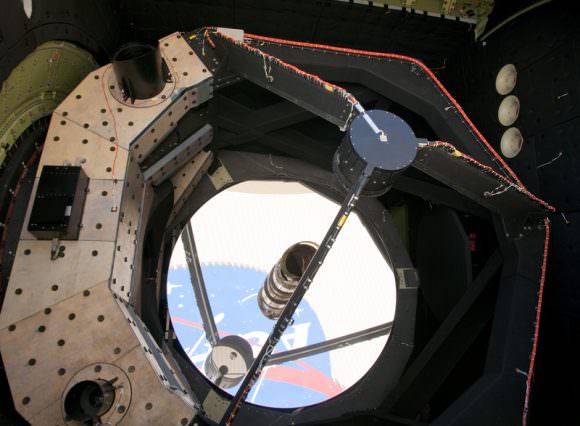
SOFIA is a specially modified Boeing 747 aircraft which carries a 100 inch telescope. It flies at altitudes between 37,000 to 45,000 feet, which puts it above most of the moisture in Earth’s atmosphere. This moisture would otherwise block the infrared radiation that SOFIA “sees.”
“Atomic oxygen in the Martian atmosphere is notoriously difficult to measure,” said Pamela Marcum, SOFIA project scientist. “To observe the far-infrared wavelengths needed to detect atomic oxygen, researchers must be above the majority of Earth’s atmosphere and use highly sensitive instruments, in this case a spectrometer. SOFIA provides both capabilities.”
A close-up of SOFIA’s telescope and primary mirror. Image: NASA/Tom Tschida
A special detector on board SOFIA, the German Receiver for Astronomy at Terahertz Frequencies (GREAT) allowed researchers to distinguish Martian atmospheric oxygen from Earthly oxygen. SOFIA-GREAT only detected half the amount of oxygen that scientists expected to find, which is probably due to changes and variations in the atmosphere. These results were published in a 2015 paper in Astronomy and Astrophysics.
Atomic oxygen has a strong effect on Mars’ atmosphere because it affects how other gases escape the atmosphere. It’s extreme volatility means it bonds with nearby molecules very easily; oxygen will combine with almost all chemical elements, except for the noble gases.
SOFIA is the largest airborne observatory in the world, and is a joint project between NASA and the German Aerospace Center. SOFIA has a 20 year mission timeline. Researchers will continue using SOFIA to study the Martian atmosphere, in order to better understand the variations in oxygen content.
SOFIA is not the only mission with eyes on Mars’ atmosphere. NASA’s Mars Atmosphere and Volatile EvolutioN (MAVEN) was launched in 2013 to explore the upper atmosphere of Mars, and how it’s affected by the solar wind. It’s thought that Mars’ atmosphere was much thicker in the past, and has been stripped away over time. Atomic oxygen played a role in Mars’ escaping atmosphere in the past, and no doubt will play a role in the future. SOFIA and other missions like MAVEN will hopefully shed some light on Mars’ past and future atmospheres.
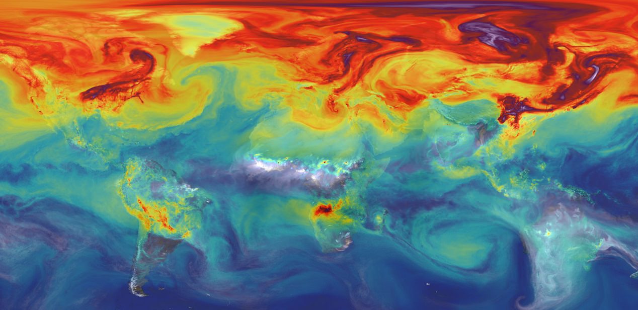
Carbon dioxide in Earth's atmosphere if half of global-warming emissions are not absorbed. Credit: NASA/JPL/GSFC
By definition, pollution refers to any matter that is “out of place”. In other words, it is what happens when toxins, contaminants, and other harmful products are introduced into an environment, disrupting its normal patterns and functions. When it comes to our atmosphere, pollution refers to the introduction of chemicals, particulates, and biological matter that can be harmful to humans, plants and animals, and cause damage to the natural environment.
Whereas some causes of pollution are entirely natural – being the result of sudden changes in temperature, seasonal changes, or regular cycles – others are the result of human impact (i.e. anthropogenic, or man-made). More and more, the effects of air pollution on our planet, especially those that result from human activity, are of great concern to developers, planners and environmental organizations, given the long-term effect they can have.
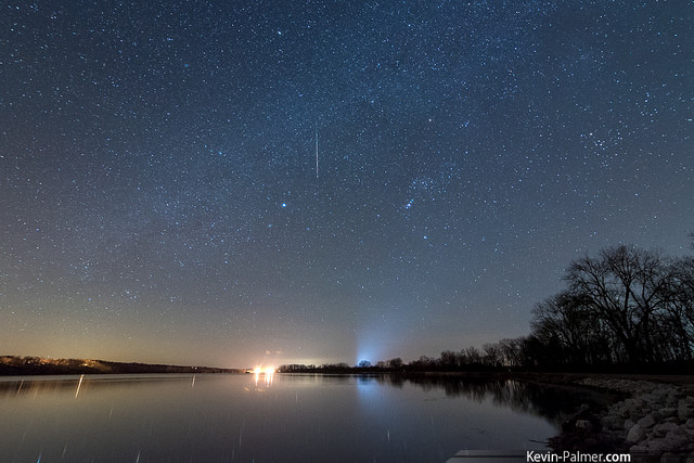
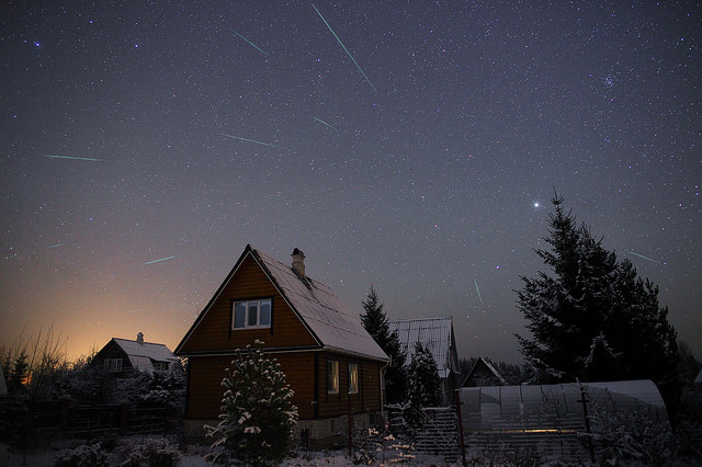
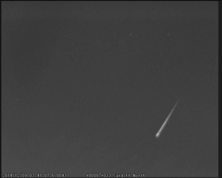
An early 2015 Geminid from the morning of December 9th. Image credit and copyright: Kevin Palmer
Author’s note: as of Thursday morning December 10th, the Geminids are already active. Canadian Meteor Orbit Radar (CMOR) has picked up a consistent stream of radio pings hailing from the constellation Gemini over the last few mornings, and reports of early Geminid activity seen by observers worldwide have been reported. If you’ve got clear skies this weekend over the next few mornings, don’t miss a sure-fire shower.
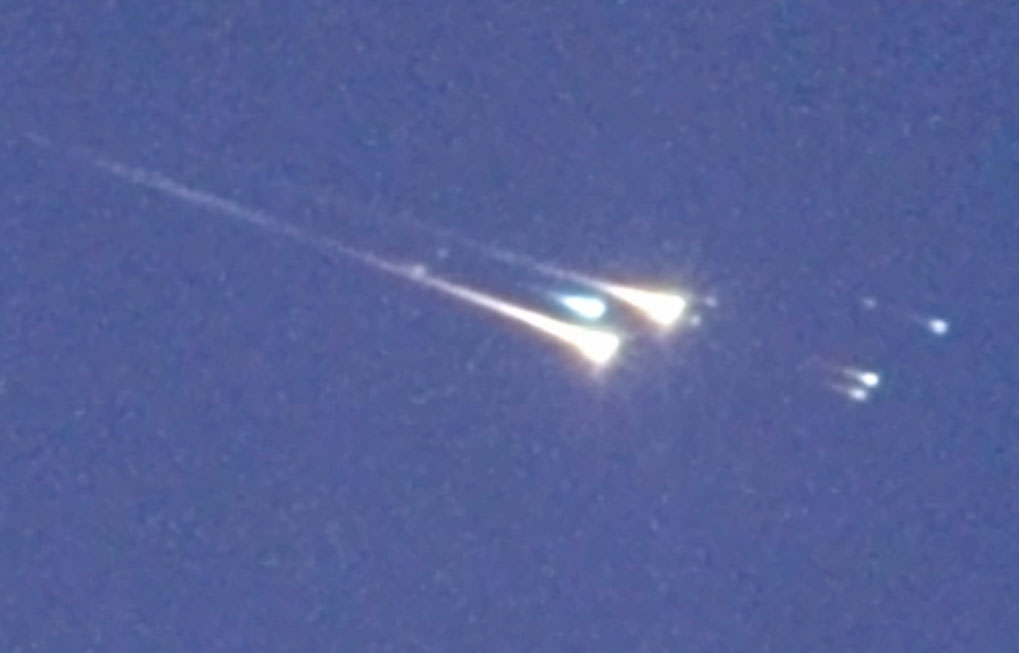
When WT1190F struck this atmosphere over the Indian Ocean around 6:20 Universal Time (12:20 a.m. CST) today , it broke apart into multiple fireballs against the blue sky. The object came down around 1:20 p.m. local time. Credit: IAC/UAE Space Agency/NASA/ESA
Clouds hampered observations from the ground in Sri Lanka during the re-entry of WT1190F overnight, but a team of astronomers captured spectacular images of the object from a high-flying plane over the Indian Ocean very close to the predicted time of arrival.
Peter Jenniskens of the SETI Institute and NASA Ames Research Center is shown here before the flight setting up the eleven staring cameras with a wider field of view, including two spectographic cameras, to catch the reentry. Credit: IAC/UAE Space Agency/NASA/ESA
The International Astronomical Center (IAC) and the United Arab Emirates Space Agency hosted a rapid response team to study the re-entry of what was almost certainly a rocket stage from an earlier Apollo moon shot or the more recent Chinese Chang’e 3 mission. In an airplane window high above the clouds, the crew, which included Peter Jenniskens, Mike Koop and Jim Albers of the SETI Institute along with German, UK and United Arab Emirates astronomers, took still images, video and gathered high-resolution spectra of the breakup.
Video and still imagery of WT1190F’s Reentry November 13, 2015
The group of seven astronomers hoped to study WT1190F’s re-entry as a test case for future asteroid entries as well as improve our understanding of space debris behavior. Photos and video show the object breaking up into multiple pieces in a swift but brief fireball. From the spectra, the team should be able to determine the object’s nature — whether natural or manmade.
Wide view of the colorful fireball and breakup when WT1190F struck Earth’s atmosphere. More than 20 cameras were used to record the event. Credit: IAC/UAE Space Agency/NASA/ESAAnimation from photos made on Nov. 12 when WT1190F was still in one piece in orbit about the Earth. Credit: Marco LangbroekFlying observatory. This Gulfstream 450 business jet, sponsored by United Arab Emirates and coordinated by Mohammad Shawkat Odeh from the International Astronomical Center, Abu Dhabi, was used by the team to observe and record the re-entry. Only five windows were available to make observations. Credit: IAC/UAE Space Agency/NASA/ESASETI Institute “staring cameras” used for wide field observations of the re-entry. Credit: IAC/UAE Space Agency/NASA/ESA
A November rain hails from the Sickle of the Lion.
Hot on the heels of the October Orionids and the Halloween fireballs of the Taurid meteors comes the Leonid meteor shower. On most years, the Leonids are a moderate shower, with hourly local rates reaching around 20. Once every 33 years, however, the Leonids are responsible for putting on one of the greatest astronomical shows ever witnessed, producing a grand storm with a zenithal hourly rate topping thousands per hour.
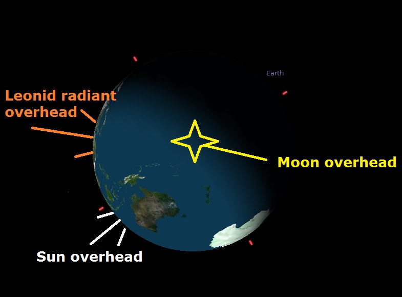
The orientation of the Earth and the relative positions of the Sun, Moon and the Leonid meteor radiant on November 17th at 4:00 UT. Image credit: Stellarium
Prospects for 2015
First, the bad news. 2015 isn’t forecast to be a ‘storm year’ for the Leonids, though that shouldn’t stop a vigilant observer from watching. The good news is, we’re just about midway betwixt the storm years of 1998-99 and 2031-32. The Leonids intensify once every 33 years, and if the increased activity seen in the late 1990s was any indication, we’d bet we’ll start seeing a pickup in rates from the Leonids in the late 2020’s or so. The good news for 2015, however, is that the peak for the Leonids occur on November 18th at around 4:00 Universal Time (UT)/ (11:00 PM EST on November 17th). This places the waxing crescent Moon out of the picture, just a day before reaching First Quarter phase. New Moon for November 2015 occurs on November 11th at 17:47 UT/12:47 PM EST.
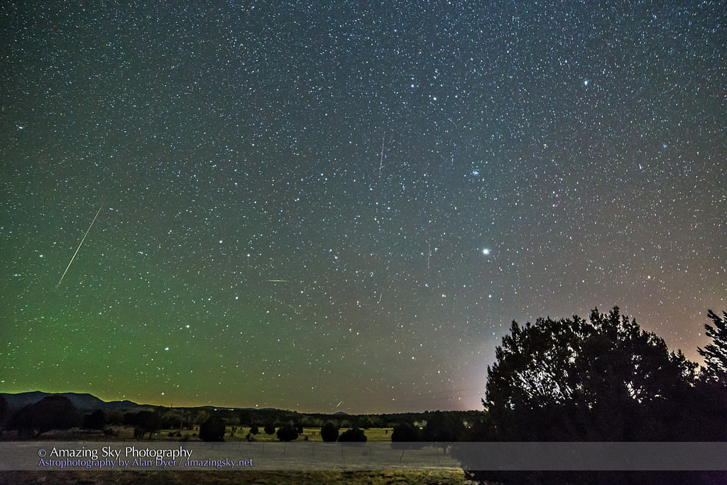
A composite of the 2014 Leonids. Image credit: Alan Dyer/Amazing Sky Photography
Fun fact: the August Perseids, November Leonids and the December Geminid meteor showers are spaced out on the calendar in such a way that, when the Moon phase is favorable for one shower on a particular year, it is nearly always favorable across all of them.
The Leonids are mildly active from November 6th through November 30th, and though the above prediction for activity in 2015 favors European longitudes at dawn, some predictions have the peak arriving up to seven hours early this year.
A simulated ‘Leonid storm.’ Note the true position of the radiant in the center of the backwards ‘?’ asterism is slightly offset. Image credit: Stellarium
The Leonids are the dusty remnants laid down by periodic comet 55P Tempel-Tuttle on its 33-year path through the inner solar system. The Leonids are fast-movers, hitting the Earth nearly head-on in the dawn. You can see this in the relative position of the radiant, which rises in mid-November around 11PM local, and reaches the zenith around 6AM local time.
A late season Leonid meteor from 2014. Image credit: The UK Monitoring network (UKMON)
Often bluish in color, the Leonids hit the Earth’s atmosphere at over 70 km/sec… almost the fastest theoretical speed possible. For best results, watch for Leonids to spike in activity close to local dawn.
A 1799 woodcut depicting the Leonids at sea. Image credit: Public Domain
The Leonids have a storied history, going back 902 AD report from Arabic annals of the ‘Year of Stars.’ The Great Meteor Storm of 1833 dazzled (and terrified) residents of the eastern seaboard of the United States, and the spectacle not only inspired astronomer Denison Olmsted to pioneer studies into the fledgling field of meteor shower science, but has been attributed to adding fervor to many of the religious revivalist movements that sprang up in the 1830s in the United States as well.
The last outburst from the Leonids that reached such an apocalyptic scale was in 1966, when observers across the southwestern United States reported hourly rates approaching an amazing ZHR=144,000. Witnesses that remember this spectacle say it produced an illusion reminiscent of the Star Trek ‘warp speed’ effect, as Earth rammed headlong into the dense Leonid meteor stream.
Our own personal encounter with a Leonid meteor storm in 1998 from the dark desert skies of Kuwait wasn’t quite that intense, but thrilling to see nonetheless. Rates neared one every few seconds towards sunrise, with several fireballs punctuating the action, lighting up the desert floor. Here, as US coalition forces were on the verge of unleashing what would become Operation: Desert Fox over Iraq, the Universe was putting on a fireworks show of its own.
The Leonid meteor storms are the stuff of astronomical legend, a once in a lifetime event. Ever since we witnessed just what the Leonids are capable of, we never miss this annual shower, as we remember one night back in 1998, and look forward to the storms of 2032.
Here’s what the Leonids have been doing on previous recent years:
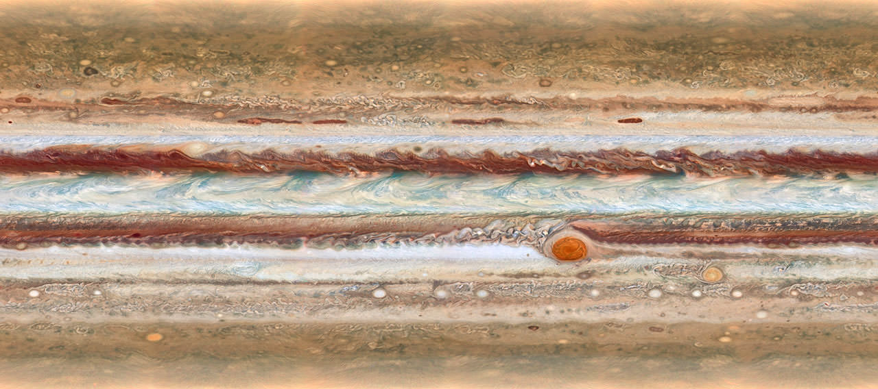
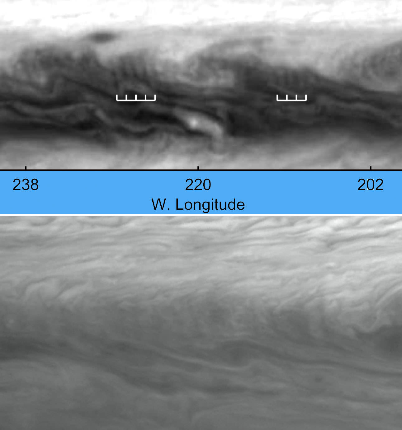
This new image from the largest planet in the Solar System, Jupiter, was made during the Outer Planet Atmospheres Legacy (OPAL) programme. The images from this programme make it possible to determine the speeds of Jupiter’s winds, to identify different phenomena in its atmosphere and to track changes in its most famous features.
The map shown was observed on 19 January 2015, from 2:00 UT to 12:30 UT.
Credit:
NASA, ESA, A. Simon (GSFC), M. Wong (UC Berkeley), and G. Orton (JPL-Caltech)
Jupiter global map created from still images from the Hubble Space Telescope
It’s been widely reported, including at Universe Today, that the apple of Jupiter’s eye, the iconic Great Red Spot (GRS), has been shrinking for decades. Even the rate of shrinkage has been steadily increasing.
Back in the late 1800s you could squeeze three Earths inside the GRS. Those were the days. Last May it measured just 10,250 miles (16,496 km) across, big enough for only 1.3 of us.
And while new photos from the Hubble Space Telescope show that Jupiter’s swollen red eye has shrunk an additional 150 miles (240 km) since 2014, the good news is that the rate of shrinkage appears to be well, shrinking. The contraction of the GRS has been studied closely since the 1930s; even as recently as 1979, the Voyager spacecraft measured it at 14,500 miles (23,335 km) across. But the alarm sounded in 2012, when amateur astronomers discovered sudden increase in the rate of 580 miles (933 km) a year along with a shift in shape from oval to roughly circular.
For the moment, it appears that the GRS is holding steady, making for an even more interesting Jupiter observing season than usual. Already, the big planet dominates the eastern sky along with Venus on October mornings. Consider looking for changes in the Spot yourself in the coming months. A 6-inch or larger scope and determination are all you need.
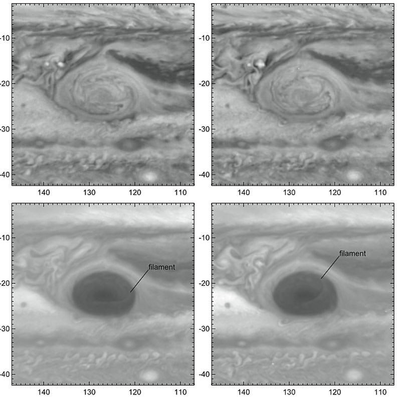
Hubble photos of the Great Red Spot taken on a first rotation (left frames) and 10 hours later (right frames) show the counterclockwise rotation of the newly-discovered filament or wisp inside the GRS. Credit: NASA, ESA, A. Simon (GSFC), M. Wong (UC Berkeley), and G. Orton (JPL-Caltech)
New imagery from the Hubble OPAL program also shows a curious wisp at the center of the Great Red Spot spanning almost the entire width of the hurricane-like vortex. This filamentary streamer rotates and twists throughout the 10-hour span of the Great Red Spot image sequence, drawn out by winds that are blowing at 335 mph (540 km/hr). Color-wise, the GRS remains orange, not red. Currently, the reddest features on the planet are the North Equatorial Belt and the occasional dark, oval “barges” (cyclonic storms) in the northern hemisphere.
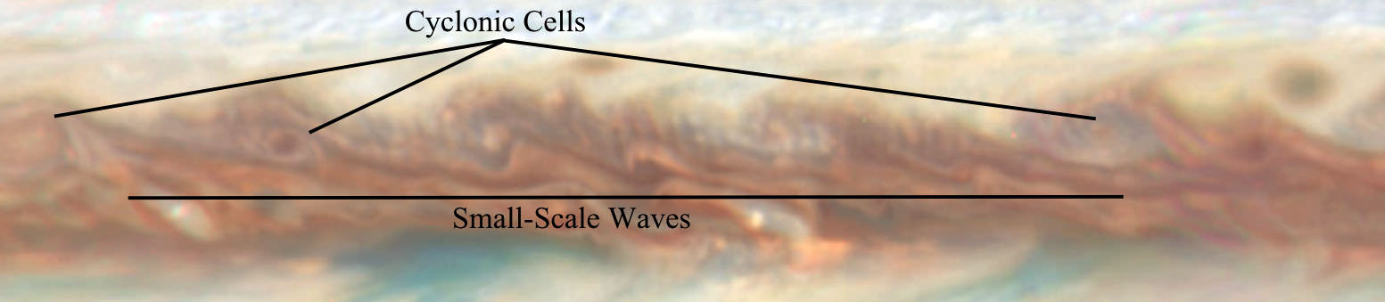
The newly-found waves in Jupiter’s atmosphere are located in regions where cyclones and anticyclones are common. They look like dark eyelashes. A cyclone is a storm or system of winds that rotates around an area of low pressure. Anticyclones spin around areas of high pressure. Credit: NASA, ESA, A. Simon (GSFC), M. Wong (UC Berkeley), and G. Orton (JPL-Caltech)
That’s not all. The photos uncovered a rare wave structure just north of Jupiter’s equator that’s only been seen once before and with difficulty by the Voyager 2 spacecraft in 1979. The scientists, whose findings are described in this just-published Astrophysical Journal paper, say it resembles an earthly atmospheric feature called a baroclinic wave,a large-scale meandering of the jet stream associated with developing storms.
Hubble view of Jupiter’s baroclinic waves on January 19, 2015 (top) and our only other view of them photographed by Voyager 2 in 1979. Credit: NASA, ESA, A. Simon (GSFC), M. Wong (UC Berkeley), and G. Orton (JPL-Caltech)
Jupiter’s “current wave” riffles across a region rich with cyclonic and anticyclonic storms. The wave may originate in a clear layer beneath Jupiter’s clouds, only becoming visible when it propagates up into the cloud deck, according to the researchers. While it’s thought to be connected to storm formation in the Jovian atmosphere, it’s a mystery why the wave hasn’t been observed more often.
The OPAL program focuses on long-term observation of the atmospheres of Jupiter, Uranus and Neptune until the end of the Saturn Cassini Mission and all four planets afterwords. We have to keep watch from Earth as no missions to Saturn and beyond are expected for quite some time. To date, Neptune and Uranus have already been observed with photos to appear (hopefully) soon in a public archive.
The September 17, 2015 total lunar eclipse - the last of the recent tetrad of lunar eclipses over the past 17 months - was darker than expected. Several factors described below were in play. This photo was taken in Washington's Olympic National Park. Credit: Rick Klawitter
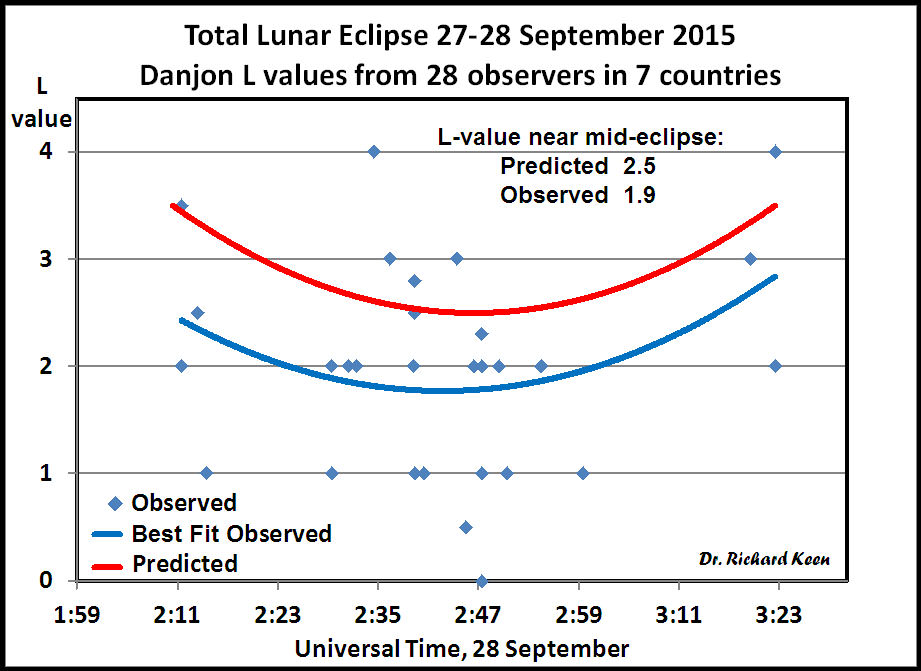
First off, a huge thank you to everyone who made and sent their Danjon scale estimate of the totally-eclipsed Moon’s brightness to Dr. Richard Keen, University of Colorado atmospheric scientist. Your data were crucial to his study of how aerosols in Earth’s atmosphere and other factors influence the Moon’s appearance.
Grateful for your help, Keen received a total of 28 observations from 7 different countries.
Graph created by Dr. Richard Keen plotting Danjon L values submitted by Universe Today readers and others that compare predicted values (top curve) with observed values. The Moon was about half as bright during totality as expected with L=1.9. Credit: Dr. Richard A. Keen
Using the Danjon information and estimates of the Moon’s brightness using the reverse binocular method, Keen crunched the data and concluded that the Moon was about 0.6 L (Danjon) units darker than expected and 0.4 magnitude dimmer, a brightness reduction of 33%. This agrees well with my own observation and possibly yours, too. No wonder so many stars sparkled near the Moon that night.
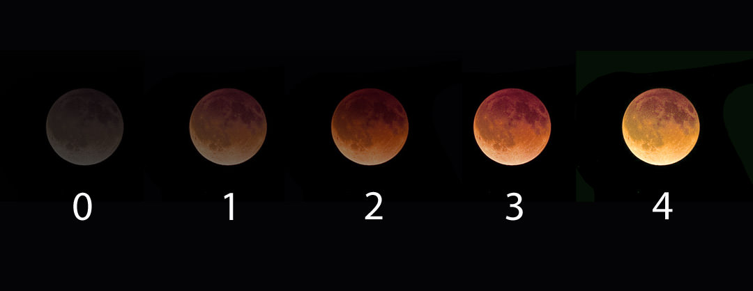
Lunar eclipse brightness is rated on the Danjon scale where “0” equals a dark gray totality and “4” a bright, coppery yellow. Credit: Bob King
I think it’s safe to say, most of us expected a normal or even bright totality. So why was it dark? Several factors were at play — one to do with the Moon’s location in Earth’s shadow, the other with a volcanic eruption and a third with long-term, manmade pollution.
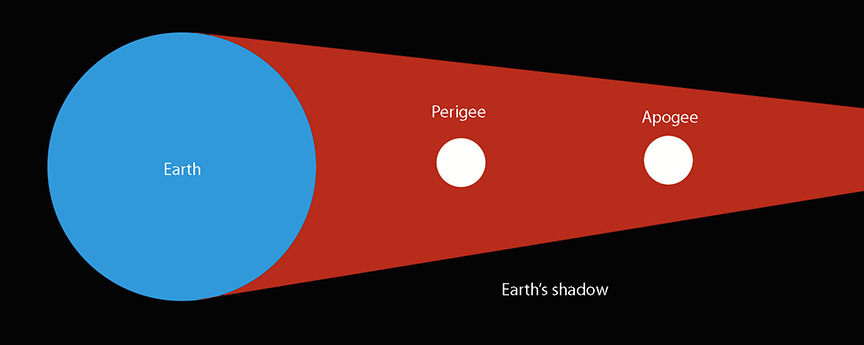
During a perigean eclipse, the Moon passes more deeply into Earth’s shadow compared to one that happens near apogee, when the moon is most distant from Earth. Moon distances not to scale and for illustration only. Credit: Bob King
You’ll recall that the eclipse occurred during lunar perigee, when the Moon swings closest to Earth in its 27-day orbit. Being closer, it also tracked deeper into Earth’s umbra or inner shadow which narrows the farther back of the planet it goes. An apogean Moon (farthest from Earth) passes through a more tapered cone of darkness closer to the penumbra, where sunlight mixes with shadow. A Moon nearer Earth would find the umbral shadow roomier with the light-leaking penumbra further off in the distance.
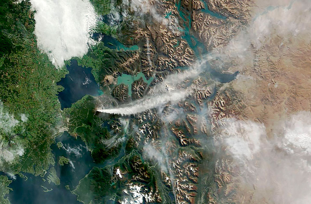
On April 24, 2015, NASA’s Terra satellite acquired this photo of the ash and gas plume from Calbuco volcano in southern Chile. Credit: NASA
But there’s more. Working independently, Steve Albersof NOAA and Brazilian astronomer Helio Vital suggested another reason: aerosols in the atmosphere. “Earth’s stratosphere is no longer completely clean of volcanic ashes,” said Vital in an e-mail communication. “In fact, lingering aerosols (ash, dust, sulfuric acid droplets) from the explosion of Calbuco five months ago may be to blame for that excessive darkening.”
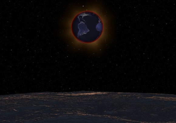
With the lunar horizon in the foreground, the Earth passes in front of the Sun on September 27, 2015 in this simulation, revealing the red ring of sunrises and sunsets along the limb of the planet responsible for illuminating the Moon during the eclipse. The clarity of the stratosphere at eclipse time can greatly affect lunar brightness during totality. The Earth and Sun are in Virgo for observers on the Moon with the bright star Beta Virginis at top. Click to see the video. Credit: NASA’s Scientific Visualization Studio
While much of the debris blasted into the stratosphere made for colorful sunsets in the southern hemisphere, some of that material has likely made its way to the northern hemisphere. Albers has noticed an increase in yellow and purple sunsets in his home town of Boulder in recent months, telltale signs of volcanic spew at play.
Forest fires that raged across the western states and Canadian provinces all spring and summer may also have contributed. Most of that smoke usually stays in the lower part of the atmosphere, but some may have found its way to the stratosphere, the very layer responsible for transmitting most of the sunlight that falls into Earth’s shadow and colors the moon.
Graph showing magnitude estimates of the Moon’s brightness during totality using the reverse binocular method. The predicted magnitude was -1.7 (a little brighter than Sirius) vs. the observed -1.3. Credit: Dr. Richard A. Keen
Sunlight has to pass through these light-absorbing minerals and chemicals on its way through the atmosphere and into Earth’s shadow. Less light means a darker moon during total eclipse. Coincidentally, much of the totally eclipsed Moon passed through the southern half of the umbra which “increased the effectiveness of the Calbuco aerosols (which are still more concentrated in the southern hemisphere than the northern) at dimming the light within the umbra,” writes Keen.
Oceanus Procellarum and Mare Imbrium are large, dark volcanic plains that contributed to the Moon’s faintness and dark-hued totality. Credit: Bob King
It also so happened that the darkest part of the moon coincided with two vast, dark volcanic plains called Oceanus Procellarum (Ocean of Storms) and Mare Imbrium, artificially enhancing the overall gloom over the northern half of the Moon.
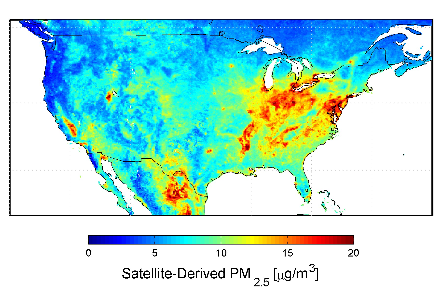
U.S. satellite-derived map of PM2.5 (fine particulate matter which includes sulfates and soot) averaged over 2001-2006. Credit: Dalhousie University, Aaron van Donkelaar
Finally, the human hand may also have played a role in lunar color and brightness. The burning of coal and oil has caused a gradual increase in the amount of human-made sulfate aerosols in the atmosphere since the start of the industrial revolution. According to NASA, at current production levels, human-made sulfate aerosols are believed to outweigh the naturally produced sulfate aerosols. No surprise that the concentration of aerosols is highest in the northern hemisphere where most industrial activity is found.
Isn’t it fascinating that one blood-red Moon can tell us so much about the air we breathe? Thank you again for your participation!
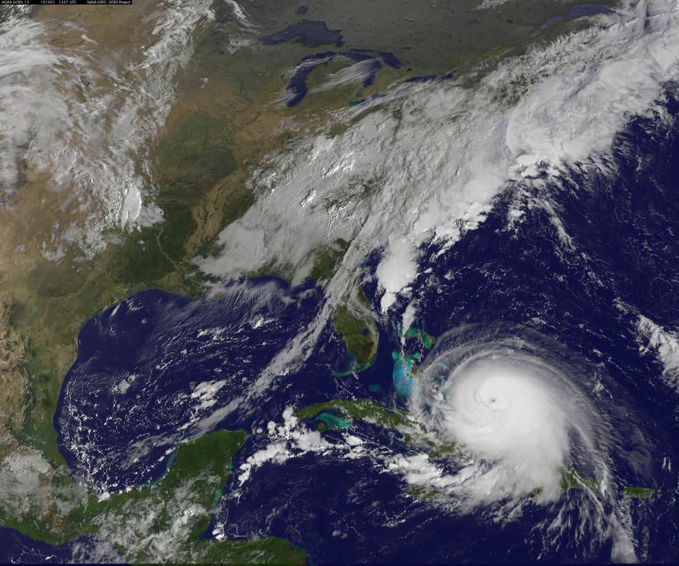
NOAA's GOES-East satellite captured this visible image of Hurricane Joaquin affecting the Bahamas on Thursday, Oct. 1 at 1255 UTC. Credits: NASA/NOAA GOES Project
Video caption: This animation of images captured from September 29 to October 1, 2015 from NOAA’s GOES-East satellite shows Hurricane Joaquin become a major hurricane in the Bahamas. Credits: NASA/NOAA GOES Project
NEW JERSEY – A wide swath of the US East Coast is bracing for impact in the coming days as ‘Hurricane Joaquin’ strengthened to a major and dangerous Category 4 storm, today, Thursday, Oct. 1, as NASA and NOAA satellites keep constant watch as it barrels potentially towards tens of millions of coastal residents.
Joaquin is already packing winds exceeding 130 mph with even higher wind gusts as the storm continues to strengthen at this hour and the pressure is decreasing. See the latest Hurricane Joaquin animation and imagery from NASA and NOAA, above and below.
A ULA Atlas V is slated to lift off Friday from Cape Canaveral Air Force Station in Florida at 6:08 a.m. EDT with the Morelos-3 communications satellite for Mexico, before the hurricane gets closer to Florida.
The National Hurricane Center declared Joaquin had intensified into a massive Category 4 hurricane on the Saffir-Simpson Wind Scale, as of 2 PM EDT today, Oct. 1.
You can watch the launch on ULA’s live webcast starting at 5:48 a.m. Oct 2: http://www.ulalaunch.com
The governors of three states – New Jersey, Virginia and North Carolina – have already declared ‘States of Emergency’ in anticipation of potentially destructive winds, potentially life threatening drenching rains and floods, downed power lines and ocean rip currents with high waves in local areas.
Multiple NASA and NOAA satellites are intensively and continuously observing Joaquin, and are providing absolutely critical data to forecasters and government officials with the most current and best information available.
NASA’s GPM, Terra and NPP-Suomi satellites and NOAA’s GOES-East satellite are tracking Joaquin and have seen powerful thunderstorms today which indicates continued strengthening.
At this time we still don’t whether the US eastern seaboard will suffer a major hit but officials are taking no chances after suffering through Superstorm Sandy which caused many deaths, widespread power outages and billions and billions of dollars of damage – from which we are still recovering.
Joaquin is currently over The Bahamas in the Caribbean and is expected to make a sharp right turn on Friday Oct 2 and head northwards to the east coast and the Atlantic Ocean. It could start impacting the Carolinas and regions further north as soon as Sunday, Oct. 4, based on current forecasts, and drop double digits inches of torrential rainfall.
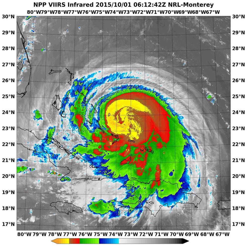
NASA-NOAA’s Suomi NPP satellite passed over Joaquin at 06:10 UTC (2:10 a.m. EDT) on Oct. 1 as it was strengthening from a Category 2 to a Category 3 hurricane. It’s now a Category 4. Imagery showed cloud top temperatures colder than -63F/-53C (yellow). Credits: NRL/NASA/NOAA
Its pounding the Bahamas right now and is creating a disaster with hurricane force winds and heavy rainfall, say weather forecasters, as it remains over the island for some 24 hours or more and may drop over 10 inches of rain.
But there is a very wide cone of uncertainly of where it could hit as the possible storm track extends from the Carolinas to Maine. It may or may not directly impact the eastern US. The storm may shift to the right and spare the east coast. But no one knows at this time.
Some areas on the US East coast stretching from Virginia to Maine have already suffered from torrential rains and severe flooding from an unrelated storm the past few days and also right now today, Thursday.
So the grounds are already saturated in parts of the Carolina’s, Virginia, Maine and elsewhere.
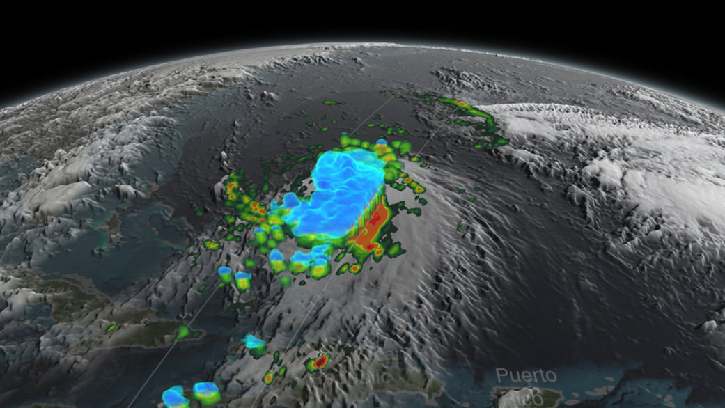
NASA/JAXA’s GPM satellite provided a 3-D side view of Tropical Storm Joaquin on Sept. 29 showing the internal precipitation structure. The areas in blue are frozen precipitation. Areas in green and red are liquid precipitation. Credits: Scientific Visualization Studio, NASA’s Goddard Space Flight Center
Coastal flood warnings and watches are already in effect in many areas along the eastern seaboard where local areas could be drenched by some 12 to 18 inches of additional rain which could fall even before the hurricane hits.
Significant beach erosion has already occurred in the Carolinas over the past few days and more is expected up and down the entire coast up to Maine.
And 10 foot high defense berms of sand are being constructed at this moment along miles and miles of the Jersey Shore – areas that suffered devastating damage from Superstorm Sandy.
There is a potential risk of deadly flooding, flash flooding and damage to houses, buildings, businesses, roadways and infrastructure.
“At 2 p.m. EDT (1800 UTC), the center of Hurricane Joaquin was located near latitude 23.0 North, longitude 74.2 West. Joaquin was moving generally southwestward at about 6 mph (9 kph), and the National Hurricane Center forecast a turn toward the northwest and north on Friday, Oct. 2. On the forecast track, the center of Joaquin will move near or over portions of the central Bahamas today and tonight and pass near or over portions of the northwestern Bahamas on Friday, Oct. 2,” according to NASAs Rob Gutro.
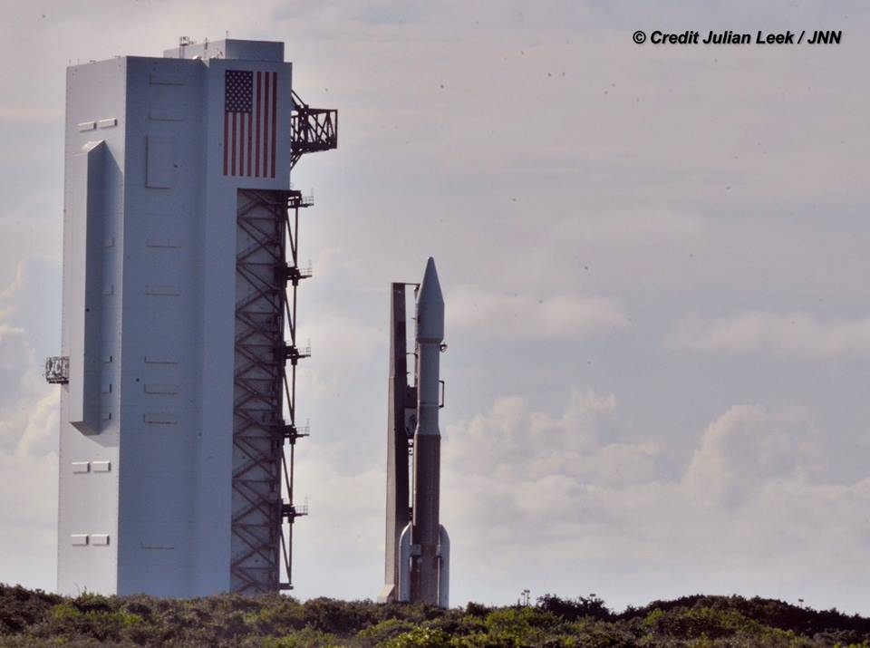
The weather forecast for Friday’s launch from Cape Canaveral , Florida is currently 70 percent GO for liftoff of the United Launch Alliance Atlas V rocket at 6:08 a.m. EDT. The Atlas V will launch with the Morelos-3 mission for Mexico’s Secretaria de Comunicaciones y Transportes (Ministry of Communications and Transportation).
Morelos-3 will be part of the Mexsat constellation of satellites that delivers advanced telecommunications throughout Mexico. United Launch Alliance Atlas V rocket after rollout to Pad 41 at Cape Canaveral Air Force Station, Florida for planned Oct. 2 launch at 6:08 a.m. EDT with the Morelos-3 mission for Mexico’s Ministry of Communications and Transportation. In progress assembly of the commercial crew access tower is seen at right, now under construction for the Boeing Starliner space taxi for astronaut crews launching to the ISS. Credit: Julian Leek
Stay tuned here for Ken’s continuing Earth and planetary science and human spaceflight news.
United Launch Alliance Atlas V rocket during rollout to Space Launch Complex-41 at Cape Canaveral Air Force Station, Florida on Oct. 1 for planned Oct. 2 launch at 6:08 a.m. EDT with the Morelos-3 mission for Mexico’s Ministry of Communications and Transportation. Credit: Julian Leek
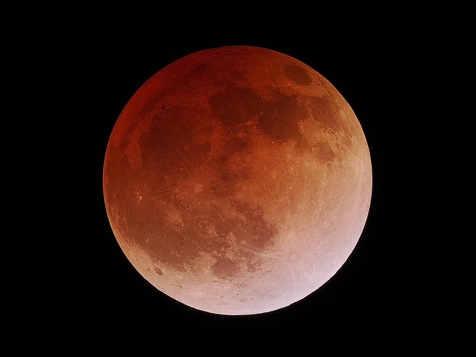
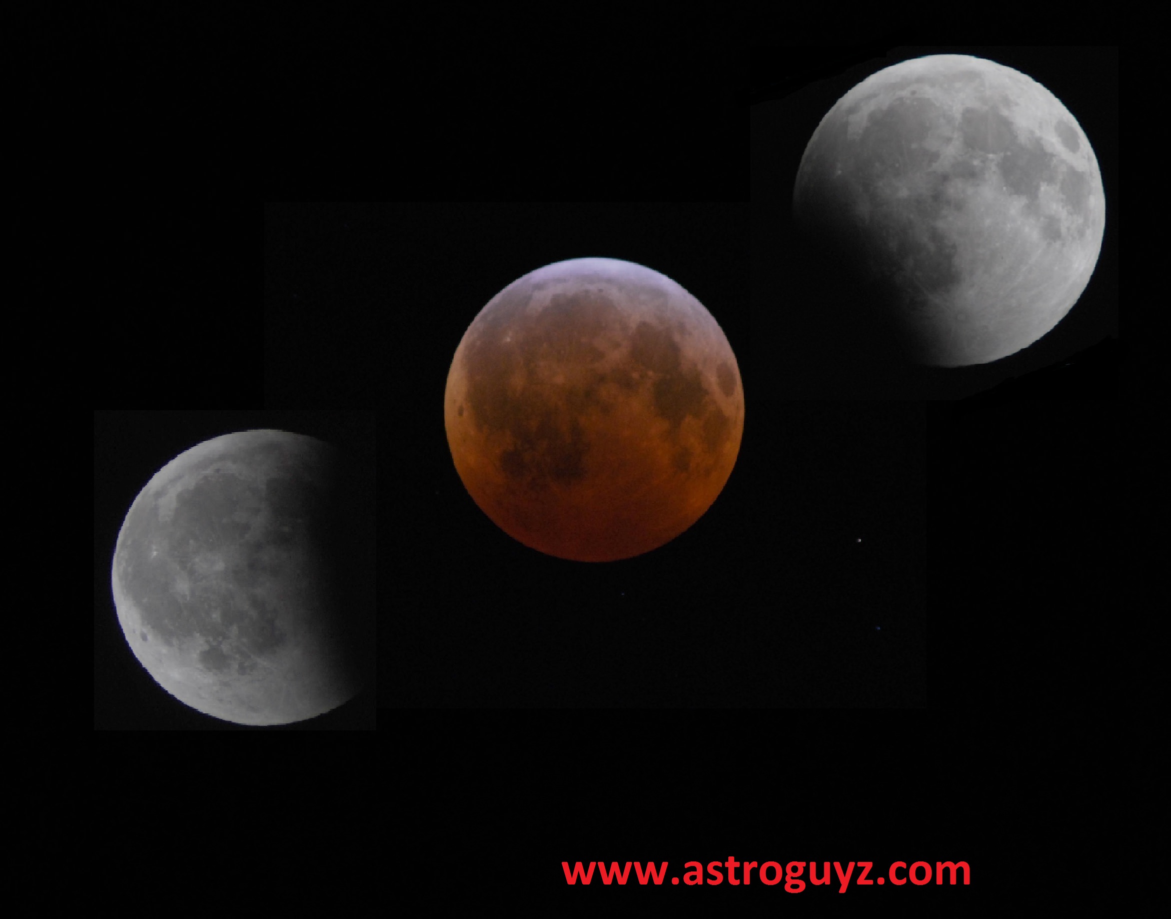
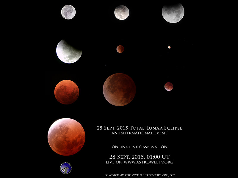
So, heard the one about this weekend’s impending ‘Super-Harvest-Blood-Moon eclipse?’ Yeah, us too. Have no fear; fortunately for humanity, the total lunar eclipse transpiring on Sunday night/Monday morning is a harbinger of nothing more than a fine celestial spectacle, clear skies willing.
This final eclipse of the ongoing lunar tetrad has some noteworthy events worth exploring in terms of science and lore.
The Specifics: First, you almost couldn’t ask for better timing. This weekend’s total lunar eclipse occurs during prime time Sunday night for North and South America, and early Monday morning for Europe, Africa and most of the Middle East. This means the Atlantic Region and surrounding areas will see totality in its entirety. This eclipse occurs very near the northward equinoctial point occupied by the Sun during the Northern Hemisphere Spring equinox in March. The date says it all: this eclipse coincides with the Harvest Moon for 2015, falling just under five days after the September equinox.
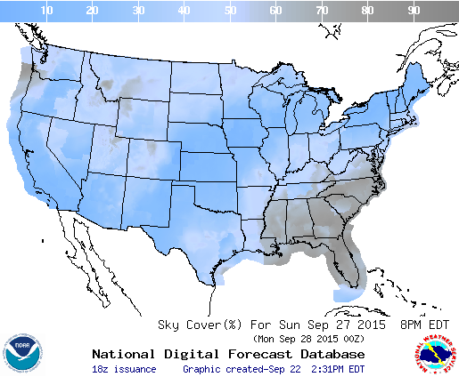
Early cloud cover prospects for Sunday night over the contiguous United States. Image credit: The National Weather Service
For saros buffs, Sunday’s eclipse is part of lunar saros series 137, member 28 of 81. This saros started back in 1564 and produced its first total lunar eclipse just two cycles ago on September 6th 1979. Saros 137 runs all the way out to its final eclipse on April 20th, 2953 AD.
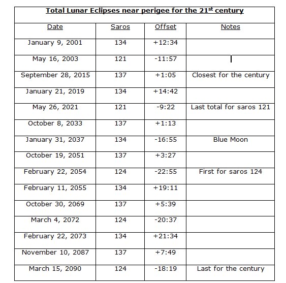
And yes, this upcoming total lunar eclipse occurs very near the closest lunar perigee for 2015. How rare are ‘Supermoon’ lunar eclipses? Well, we took a look at the phenomenon, and found 15 total lunar eclipses occurring near lunar perigee for the current century:
Perigee eclipses for the 21st century. To make the cut, a total lunar eclipse needed to occur within 24 hours of lunar perigee. Image credit: Dave Dickinson
You’ll note that four saroses (the plural of saros) are producing perigee or ‘Proxigean’ total lunar eclipses during this century, including saros 137.
Does the perigee Moon effect the length of totality? It’s an interesting question. Several factors come into play that are worth considering for Sunday night’s eclipse. First, the Moon moves a bit faster near perigee as per Kepler’s second law of motion. Second, the Moon is a shade larger in apparent size, 34’ versus 29’ near apogee. Lastly, the conic section of the Earth’s shadow or umbra is a bit larger closer in; you can fit three Moons side-by-side across the umbra around 400,000 kilometers out from the Earth. Sunday night’s perigee occurs 65 minutes after Full Moon at 2:52 UT/10:52 PM EDT. Perigee Sunday night is 356,876 kilometers distant, the closest for 2015 by just 115 kilometers, and just under 500 kilometers short of the closest perigee that can occur. This is, however, the closest perigee time-wise to lunar totality for the 21st century; you have to go all the way back to 1897 to find one closer, at just four minutes apart.
This all culminates in a period for totality on Sunday night of just under 72 minutes in duration, 35 minutes shy of the maximum possible for a central total lunar eclipse. An eclipse won’t top this weekend’s in terms of duration until January 31st 2018.
Here are the key times to watch for on Sunday night:
Penumbral phase begins: 00:12 UT/8:12 PM EDT (on the 27th)
Partial phase begins: 1:07 UT/9:07 PM EDT
Totality begins: 2:11 UT/10:11 PM EDT
Totality ends: 3:23 UT/11:23 PM EDT
Partial phase ends: 4:27 UT/00:27 AM EDT
Penumbral phase ends: 5:22 UT/1:22 AM EDT
Note that one 18 year 11 day and 8 hour saros period later, saros 137 will again produce a perigee eclipse nearly as close as this weekend’s on October 8th, 2033.
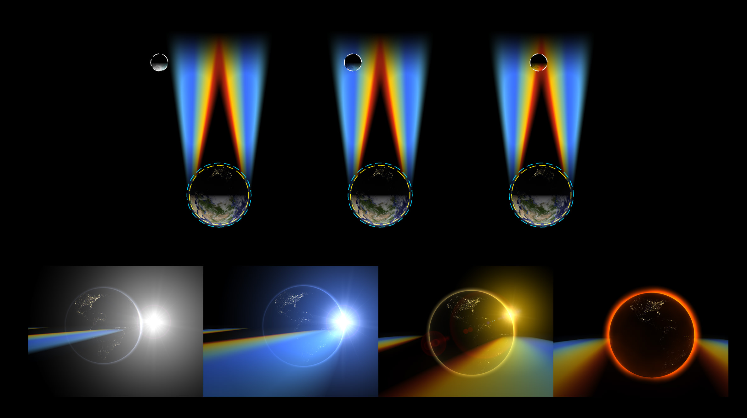
The classic hallmark of any total lunar eclipse is the reddening of the Moon. You’re seeing the combination of all the world’s sunsets, refracted into the inky umbra of the Earth and cast upon the surface of the Moon. To date, no human has stood upon the surface of the Moon and gazed upon the spectacle of a solar eclipse caused by the Earth.
The orientation of the Sun and Earth as seen from the Moon during Sunday night’s eclipse. Image credit: Stellarium
Not all eclipses are created equal when it comes to hue and color. The amount of dust and aerosols suspended in the atmosphere can conspire to produce anything from a bright, yellowish-orange tint, to a brick dark eclipse where the Moon almost disappears from view entirely. The recent rapid fire tetrad of four eclipses in 18 months has provided a good study in eclipse color intensity. The deeper the Moon dips into the Earth’s shadow, the darker it will appear… last April’s lunar eclipse was just barely inside the umbra, making many observers question if the eclipse was in fact total at all.
Refraction of sunlight during a total lunar eclipse. Image credit: Raycluster/Public Domain
We the describe color of the eclipsed Moon in terms of its number on the Danjon scale, and recent volcanic activity worldwide suggests that we may be in for a darker than normal eclipse… but we could always be in for a surprise!
Old time mariners including James Cook and Christopher Columbus used positional measurements of the eclipsed Moon at sea versus predictions published in almanac tables for land-based observatories to get a one-time fix on their longitude, a fun experiment to try to replicate today. Kris Columbus also wasn’t above using beforehand knowledge of an impending lunar eclipse to help get his crew out of a tight jam.
A long timelapse of totality during a 2003 total lunar eclipse, back from the glorious days of film. Image credit: Dave Dickinson
And speaking of the next perigee Moon total lunar eclipse for saros 137 on October 8th, 2033… if you catch that one, this weekend’s, and saw the September 16th, 1997 lunar eclipse which spanned the Indian Ocean region, you’ll have completed an exeligmos, or a triple saros of eclipses in the same series 54 years and 33 days in length, an exclusive club among eclipse watchers and a great word to land on a triple letter word score in Scrabble…
The 2010 winter solstice eclipse. Image credit: Dave Dickinson
Here’s another neat challenge: the International Space Station makes two shadow passes during the lunar eclipse over the contiguous United States. The first one occurs during totality, and spans from eastern Louisiana to central Maine from 2:14 to 2:20 UT; the second pass occurs during the final partial phases of the eclipse spanning from southern Arizona to Lake Superior from 3:47 to 3:54 UT. These are un-illuminated shadow passes of the ISS. Observers have captured transits of the ISS during a partial solar eclipse, but to our knowledge, no one has ever caught a transit of the ISS during a total lunar eclipse; ISS astros should also briefly be able to spy the eclipsed Moon from their orbital vantage point. CALSky will have refined passage times about 48 hours prior to Sunday.
Projections for ISS shadow passes across the Moon during Sunday night’s eclipse. The first path occurs during totality, and the second during the final partial phases of the eclipse. Image credit: Dave Dickinson/calculations from CALSky
Clouded out? Live on the wrong side of the planet? The good folks at the Virtual Telescope Project have got you covered, with a live webcast of the total lunar eclipse starting at 1:00 UT/9:00 PM EDT.
Image credit: The Virtual Telescope Project
And as the eclipse draws to an end, the question of the hour always is: when’s the next one? Well, the next lunar eclipse is a dim penumbral on March 23rd, 2016, which follows a total solar eclipse for southeastern Asia on March 9th, 2016… but the next total lunar won’t occur until January 31st, 2018, which also happens to be the second Full Moon of the month… a ‘Blue Blood Moon Eclipse?’
Sorry, we had to go there. Hey, we could make the case for Sunday’s eclipse also occurring on World Rabies Day, but perhaps a ‘Rabies Eclipse’ just doesn’t have the SEO traction. Don’t fear the Blood Moon, but do get out and watch the final lunar eclipse of 2015 on Sunday night!
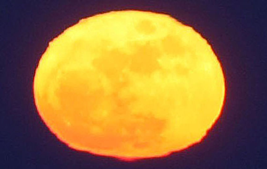
A Full Moon in all its horizontal glory. When near the horizon, refraction squeezes the lunar disk into an oval. Scattering removes the shorter wavelengths of white light, leaving the Moon a rich red or orange. Credit: Bob King
Who doesn’t love a Full Moon? Occurring about once a month, they never wear out their welcome. Each one becomes a special event to anticipate. In the summer months, when the Moon rises through the sultry haze, atmosphere and aerosols scatter away so much blue light and green light from its disk, the Moon glows an enticing orange or red.
At Full Moon, we’re also more likely to notice how the denser atmosphere near the horizon squeezes the lunar disk into a crazy hamburger bun shape. It’s caused by atmospheric refraction. Air closest to the horizon refracts more strongly than air near the top edge of the Moon, in effect “lifting” the bottom of the Moon up into the top. Squished light! We also get to see all the nearside maria or “seas” at full phase, while rayed craters like Tycho and Copernicus come into their full glory, looking for all the world like giant spatters of white paint even to the naked eye.
At full phase, the Moon lies directly opposite the Sun on the other side of Earth. Sunlight hits the Moon square on and fully illuminates the Earth-facing hemisphere. Credit: Bob King
Tomorrow night (August 29), the Full Sturgeon Moon rises around sunset across the world. The name comes from the association Great Lakes Indian groups made between the August moon and the best time to catch sturgeon. Next month’s moon is the familiar Harvest Moon; the additional light it provided at this important time of year allowed farmers to harvest into the night.
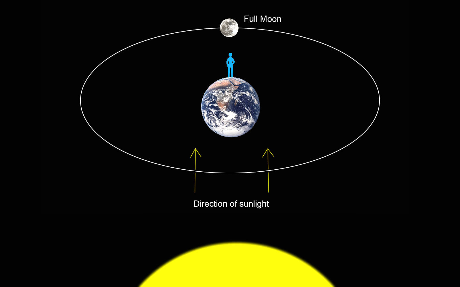
A Full Moon lies opposite the Sun in the sky exactly like a planet at opposition. Earth is stuck directly between the two orbs. As we look to the west to watch the Sun go down, the Moon creeps up at our back from the eastern horizon. Full Moon is the only time the Moon faces Sun directly – not off to one side or another – as seen from Earth, so the entire disk is illuminated.
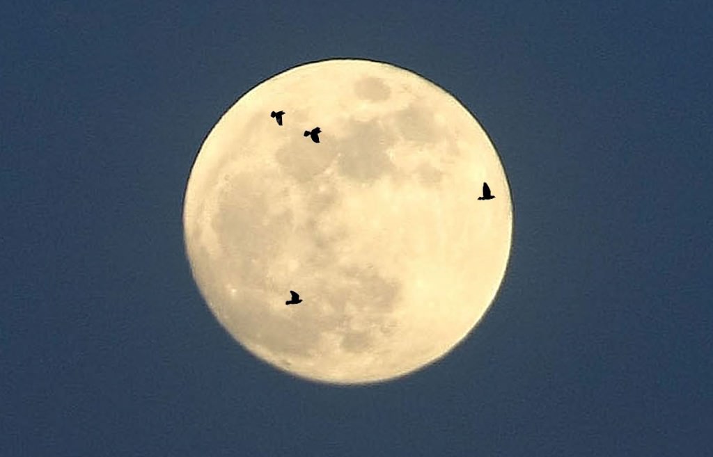
The moon provides the perfect backdrop for watching birds migrate at night. Although a small telescope is best, you might see an occasional bird in binoculars, too. Credit: Bob King
If you’re a moonrise watcher like I am, you’ll want to find a place where you can see all the way down to the eastern horizon tomorrow night. You’ll also need the time of moonrise for your city and a pair of binoculars. Sure, you can watch a moonrise without optical aid perfectly well, but you’ll miss all the cool distortions happening across the lunar disk from air turbulence. Birds have also begun their annual migration south. Don’t be surprised if your glass also shows an occasional winged silhouette zipping over those lunar seas.
Because the Moon’s orbit is tilted 5.1° with respect to Earth’s, it normally passes above or below Earth’s shadow with no eclipse — either lunar or solar. Only when the lineup is exact, does the Moon pass directly behind Earth and into its shadow. Credit: Bob King
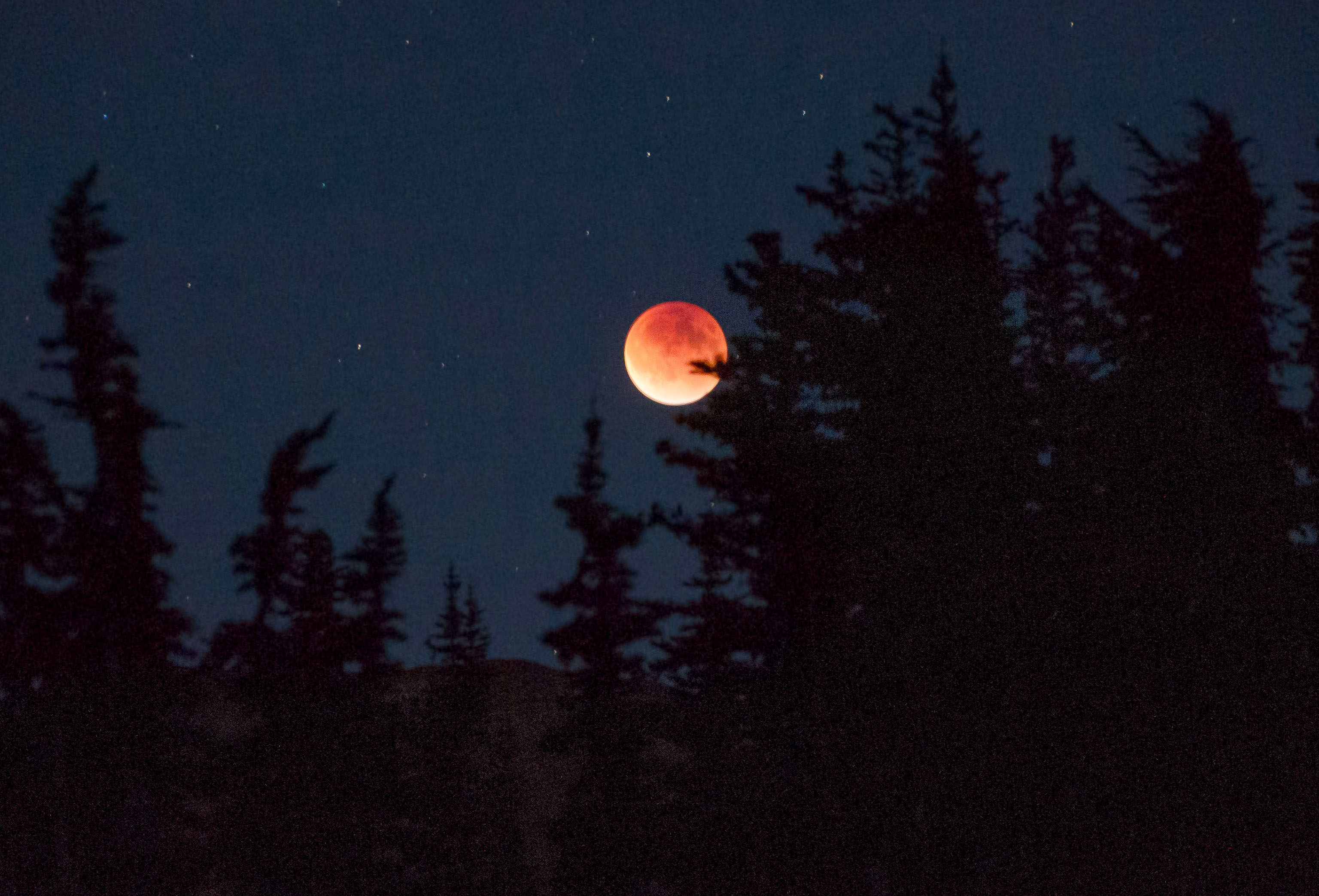
Next month’s Full Moon is very special. A few times a year, the alignment of Sun, Earth and Moon (in that order) is precise, and the Full Moon dives into Earth’s shadow in total eclipse. That will happen overnight Sunday night-Monday morning September 27-28. This will be the final in the current tetradof four total lunar eclipses, each spaced about six months apart from the other. I think this one will be the best of the bunch. Why?
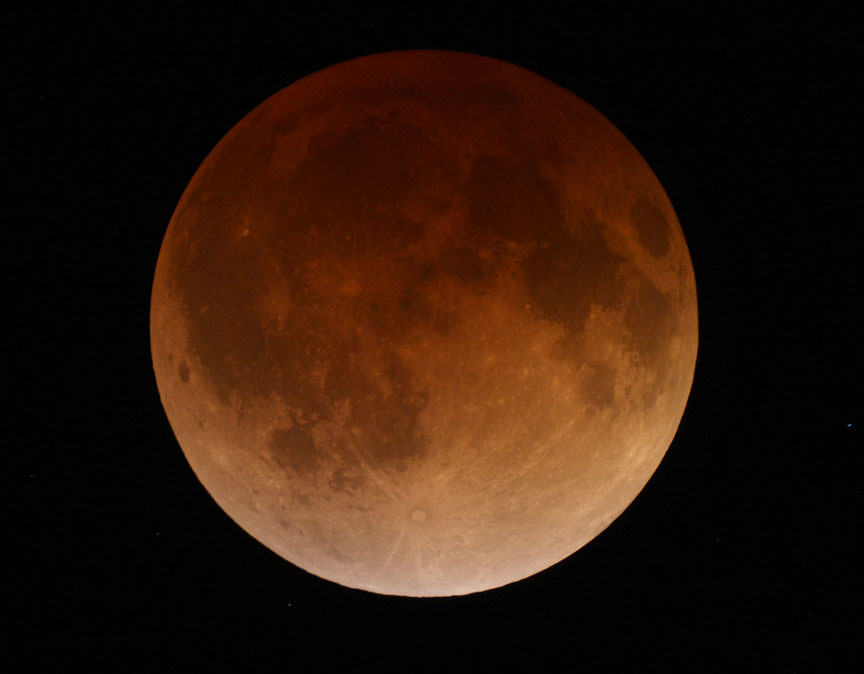
The totally eclipsed moon on April 15, 2014 from Duluth, Minn. This was the first in the series of four eclipses called a tetrad. September’s totally eclipsed Moon will appear similar. The coloring comes from sunlight grazing the edge of Earth’s atmosphere and refracted by it into the planet’s shadow. Credit: Bob King
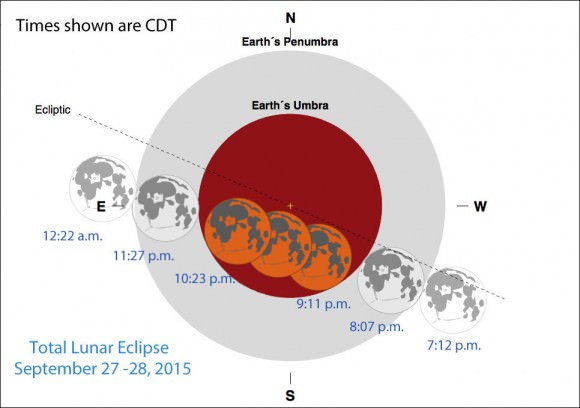
Convenient evening viewing hours (CDT times given) for observers in the Americas. Partial eclipse begins at 8:07 p.m., totality lasts from 9:11 – 10:23 p.m. and partial eclipse ends at 11:27 p.m. Those times mean that for many regions, kids can stay up and watch.
The Moon passes more centrally through Earth’s shadow than during the last total eclipse. That means a longer totality and possibly more striking color contrasts.
September’s will be the last total eclipse visible in the Americas until January 31, 2018. Between now and then, there will be a total of four minor penumbral eclipses and one small partial. Slim pickings.
Diagram showing the details of the upcoming total lunar eclipse. The event begins when the Moon treads into Earth’s outer shadow (penumbra) at 7:12 p.m. CDT. Partial phases start at 8:07 and totality at 9:11. Credit: NASA / Fred Espenak
Not only will the Americas enjoy a spectacle, but totality will also be visible from Europe, Africa and parts of Asia. For eastern hemisphere skywatchers, the event will occur during early morning hours of September 28. Universal or UT times for the eclipse are as follows: Partial phase begin at 1:07 a.m., totality from 2:11 – 3:23 a.m. with the end of partial phase at 4:27 a.m.
September 27-28, 2015 eclipse visibility map. Credit: NASA / Fred Espenak
We’ll have much more coverage on the upcoming eclipse in future articles here at Universe Today. I hope this brief look will serve to whet your appetite and help you anticipate what promises to be one of the best astronomical events of 2015.