"The Chemistry of the Solar System" by Compound Interest's Andy Brunning
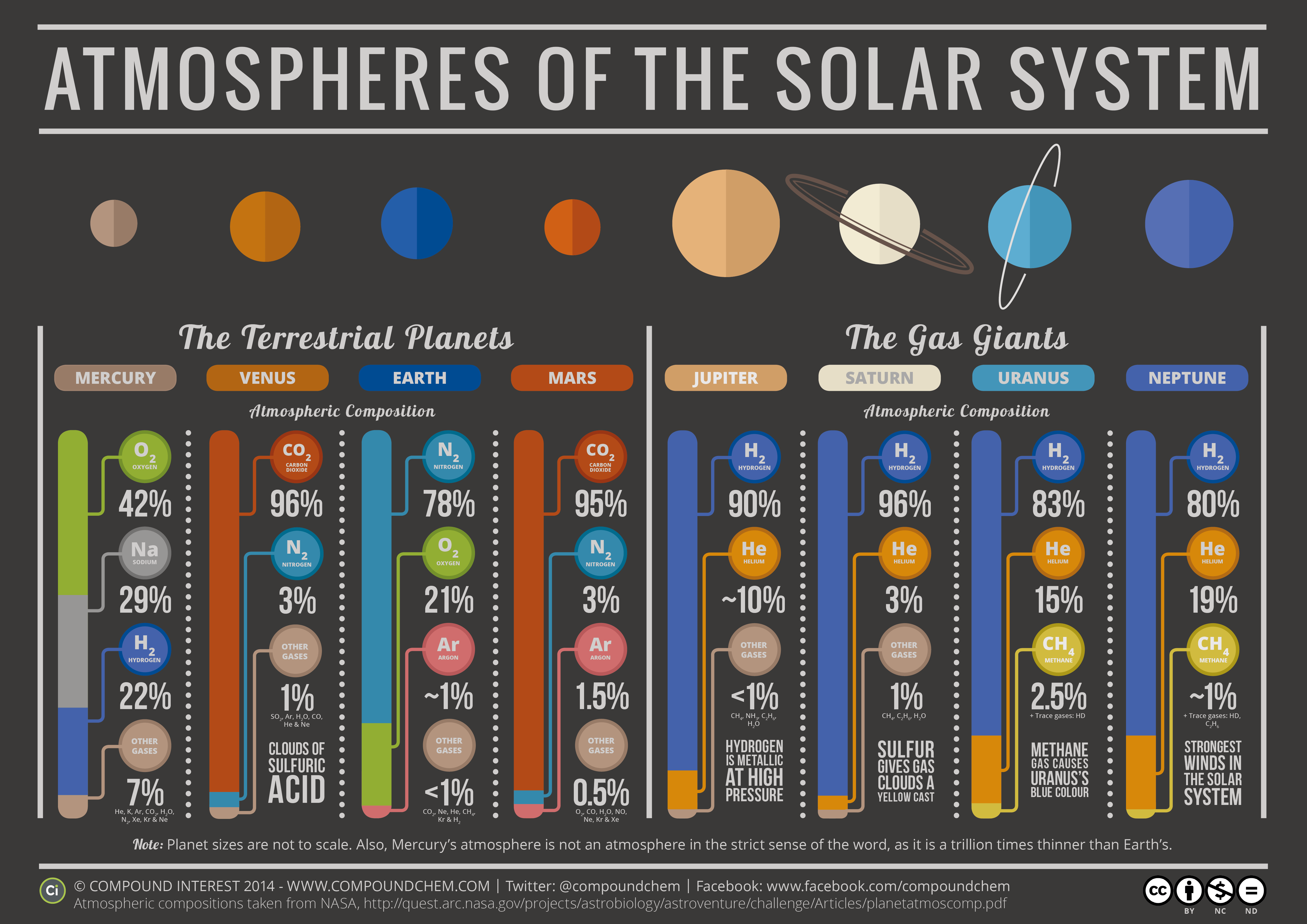
Here on Earth we enjoy the nitrogen-oxygen atmosphere we’ve all come to know and love with each of the approximately 24,000 breaths we take each day (not to mention the surprisingly comfortable 14.7 pounds per square inch of pressure it exerts on our bodies every moment.) But every breath we take would be impossible (or at least quickly prove to be deadly) on any of the other planets in our Solar System due to their specific compositions. The infographic above, created by UK chemistry teacher Andy Brunning for his blog Compound Interest, breaks down — graphically, that is; not chemically — the makeup of atmospheres for each of the planets. Very cool!
In addition to the main elements found in each planet’s atmosphere, Andy includes brief notes of some of the conditions present.
“Practically every other planet in our solar system can be considered to have an atmosphere, apart from perhaps the extremely thin, transient atmosphere of Mercury, with the compositions varying from planet to planet. Different conditions on different planets can also give rise to particular effects.”
– Andy Brunning, Compound Interest
And if you’re thinking “hey wait, what about Pluto?” don’t worry — Andy has included a sort of postscript graphic that breaks down Pluto’s on-again, off-again atmosphere as well. See this and more descriptions of the atmospheres of the planets on the Compound Interest blog here.
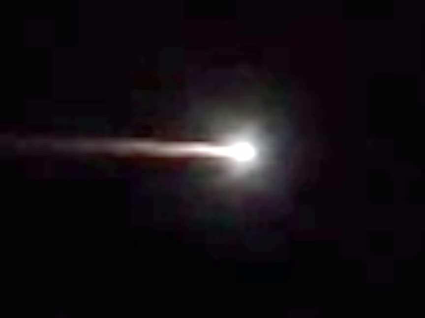
Frame grab from a Youtube video of the brilliant meteor that flared over Australia overnight.
“It first looked like a plane with fire coming out of the tail.”— Aaron O.
“I have never seen anything like it. Big, bright and moving gently across sky – slower than a plane, not falling at all but moving across.” — Shannon H.
“Viewed from cockpit of aircraft at 37,000′. Was visible for two or three minutes.”— Landy T.
Flaming plane? Incandescent visitor from the asteroid belt? As the these comments from the AMS Fireball Log attest, the brilliant and s-l-o-w fireball that seared the sky over southeastern Australia tonight was probably one of the most spectacular displays of re-entering space junk witnessed in recent years.
Ted Molczan, citizen satellite tracker and frequent contributor to the amateur satellite watchers SeeSat-L site, notes that the timing and appearance almost certainly point to the decay or de-orbiting of the Russian Soyuz 2-1B rocket booster that launched the meteorological satellite Meteor M2 on July 8.
Meteor over New South Wales. Look closely near the end and you’ll see it disintegrate into small pieces.
The magnificent man-made meteor, weighing some 4,400 pounds (2,000 kg), was seen from Melbourne to Sydney across the states of Victoria and New South Wales around 10 p.m. Hundreds of people were stopped in their tracks. Most noticed how slowly the fireball traveled and how long it continue to burn on the way down.
Spacecraft that reenter from either orbital decay or controlled entry usually break up at altitudes between 45-52 miles (84-72 km) traveling around 17,500 mph (28,000 km/hour) . Compression and friction from the ever-thickening air cause the craft, or in this case, the rocket booster, to slow down and heat up to flaming incandescence just like a hunk of space rock arriving from the asteroid belt. In both cases, we see a brilliant meteor, however manmade debris.
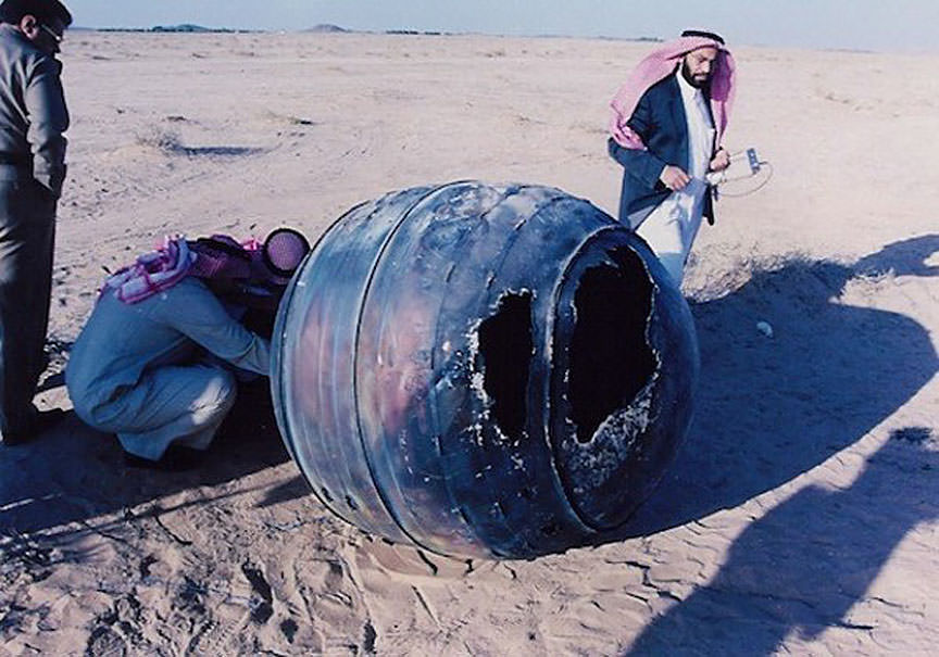
A Delta 2 third stage, known as a PAM-D, reentered the atmosphere over the Middle East on Jan. 21, 2001. The titanium motor casing, weighing about 154 lbs. (70 kg), landed in Saudi Arabia about 150 miles from the capital of Riyadh. Credit: NASA, Orbital Debris Program Office
Occasional meteoroids break apart in the atmosphere and scatter meteorites just as pieces of occasional satellites, especially large, heavy craft, can survive the plunge and land intact – if a tad toasted. Whether anything remains of Russian rocket stage or where exactly it fell is still unknown. Here are a few more photos of successful space junk arrivals.
The only person to be hit by manmade space debris was Lottie Williams in 1997. She was unharmed. Credit: Tulsa World
Reportedly, only one person has been struck by satellite debris. In 1997 Lottie Williams of Tulsa, Oklahoma was hit on the shoulder while walking by a small, twisted piece of metal weighing as much as a crushed soda can. It was traced back to the tank of a Delta II rocket that launched a satellite in 1996. I suppose it’s only a matter of time before someone else gets hit, but the odds aren’t great. More likely, you’ll see what alarmed and delighted so many southeastern Australians Thursday night: a grand show of disintegration.
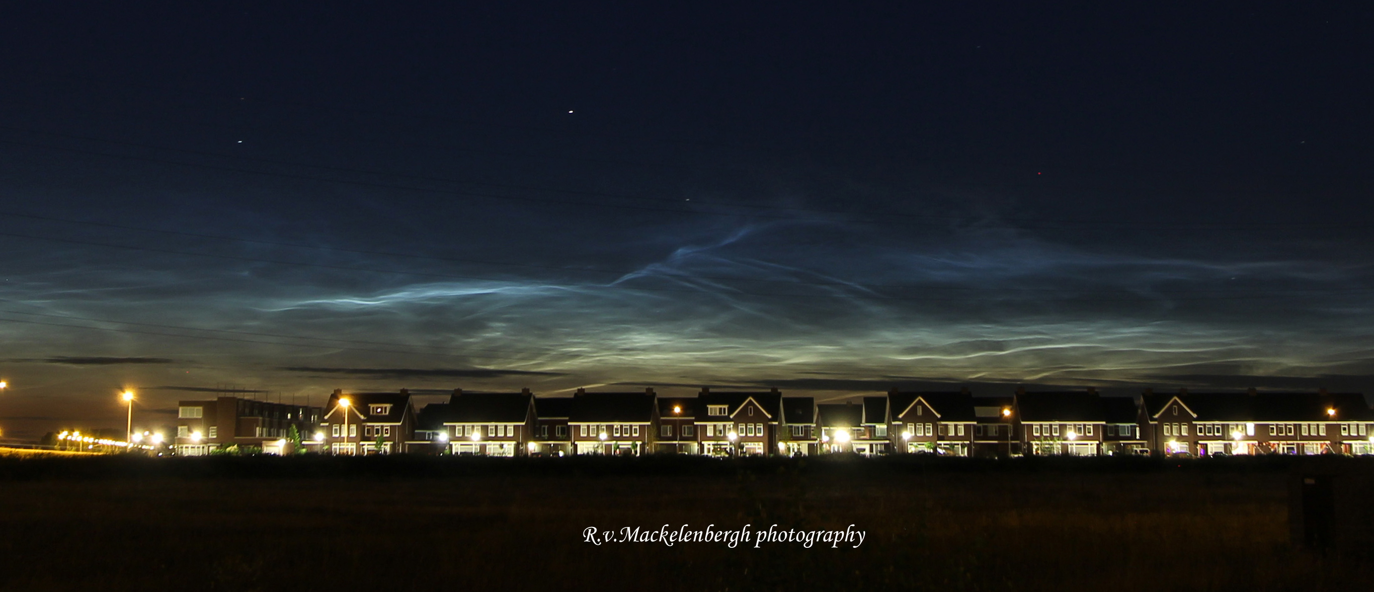
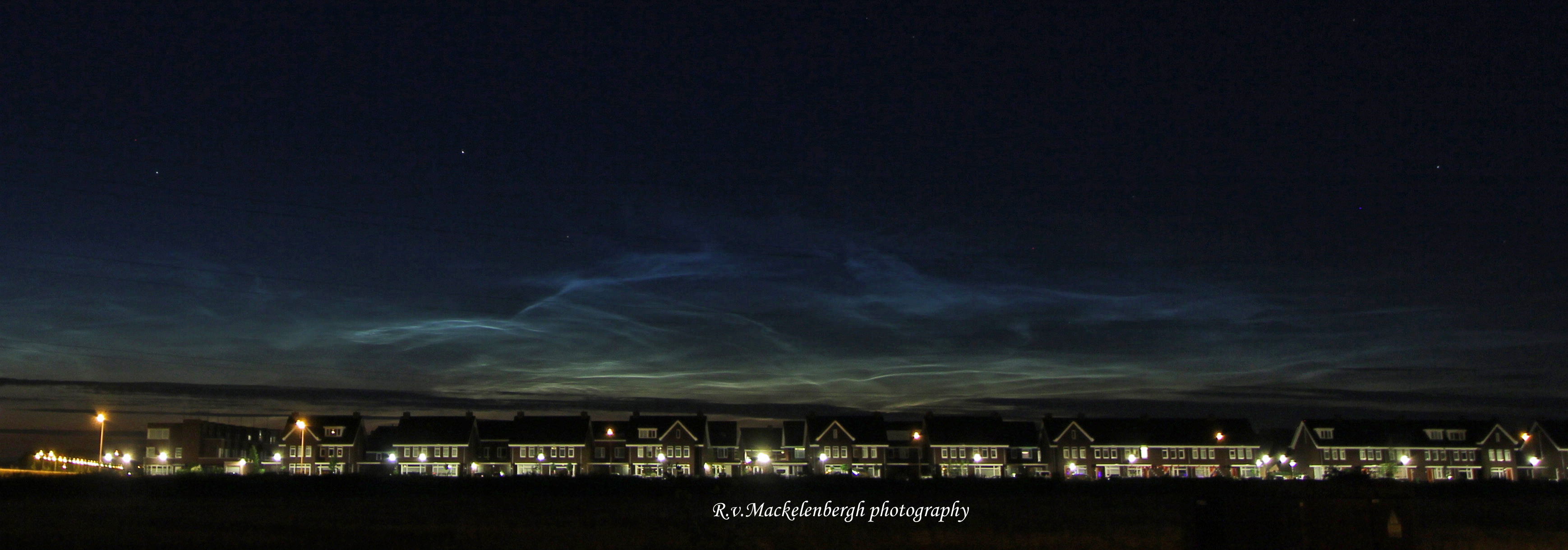
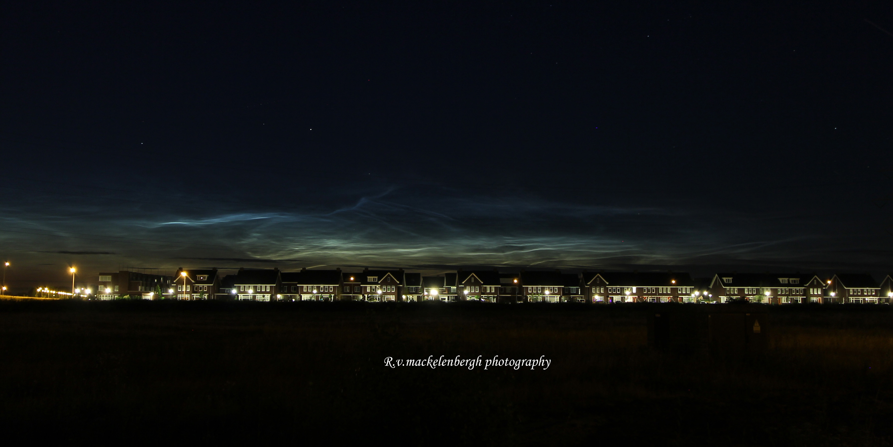
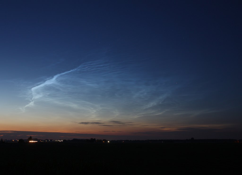
Noctilucent clouds over the city of Rosmalen, Holland, July 3, 2014. Taken with Canon 60D, 28 mm lens. Credit: Rob van Mackelenbergh
A trio of talented Dutch astrophotographers have captured a series of magnificent views of the rare and beautiful phenomena known as Noctilucent Clouds, or NLCs, during a spectacular outburst on the night of July 3, 2014 in the dark skies over southern Holland – coincidentally coinciding with the fireworks displays of the Dutch 2014 FIFA World Cup team and America’s 4th of July Independence Day celebrations!
“I suddenly saw them above my city on the night of July 3rd and ran for my camera!” said Dutch astrophotographer Rob van Mackelenbergh, who lives in the city of Rosmalen and excitedly emailed me his photos – see above and below.
“I was lucky to see them because I left work early.”
Noctilucent clouds are rather mysterious and often described as “alien looking” with “electric-blue ripples and pale tendrils reaching across the night sky resembling something from another world,” according to a NASA description.
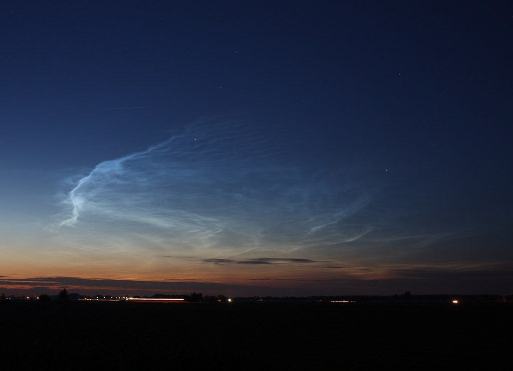
Noctilucent clouds over the city of Rosmalen, Holland, July 3, 2014. Taken with Canon 60D, 28 mm lens. Credit: Rob van Mackelenbergh
They are Earth’s highest clouds, forming on tiny crystals of water ice and dust particles high in the mesosphere near the edge of space by a process known as nucleation, at altitudes of about 76 to 85 kilometers (47 to 53 miles).
NLCs are generally only visible on rare occasions in the late spring to summer months in the hours after sunset and at high latitudes – 50° to 70° north and south of the equator.
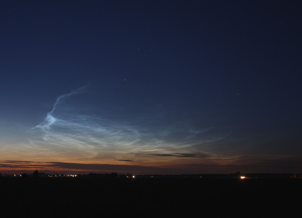
Noctilucent clouds over the city of Rosmalen, Holland, July 3, 2014. Taken with Canon 60D, 28 mm lens. Credit: Rob van Mackelenbergh
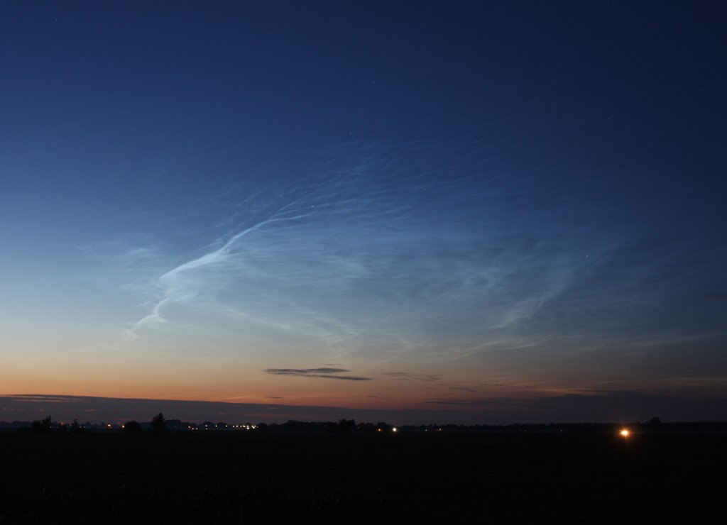
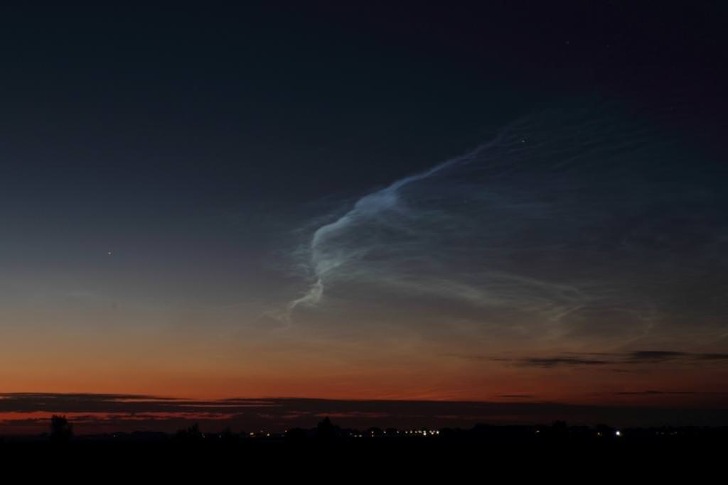
Another pair of Dutch guys, Raymond Westheim and Edwin van Schijndel, quickly hit the road to find a clear view when they likewise saw the mesmerizingly colorful and richly hued outburst on July 3rd and also sent me their fabulous NLC photos.
“To have a free view to the horizon, we drove to the countryside just north of the city of Oss. On a small road we have stopped to witness these beautiful NLCs and to take pictures,” said Westheim.
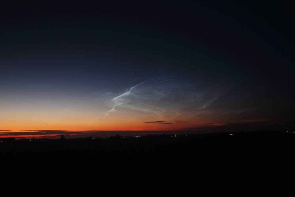
Late night Noctilucent clouds outside Oss, Holland, July 3, 2014. Taken with Canon EOS 450D, 17-40 mm lens, ISO 200, f=5.6, exposure time 5-15 seconds. Credit: Raymond Westheim
See a gallery of Raymond’s and Edwin’s photos herein.
“The NLCs of last night were the most beautiful ones since 2010. They were remarkably bright and rapidly changing and could be seen drifting towards the South,” Westheim explained with glee.
“These pictures were taken a few kilometers north of our city Oss between 23:15 p.m. and 0:15 a.m. (Central Europe Time) on Thursday evening, July 3,” said Edwin van Schijndel.
Noctilucent clouds near Oss, Holland on July 3, 2014. Taken with Canon EOS 60 D, 17 – 40 Canon lens, exposure time 2 to 4 seconds, ISO 200. Credit: Edwin van Schijndel
Rob, Raymond and Edwin are all members of the “Sterrenwacht Halley” Observatory which was built in 1987. It houses a planetarium and a Celestron C14 Schmidt-Cassegrain telescope. The observatory is located about 50 kilometers from the border with Belgium, near Den Bosch – the capitol city of southern Holland. The well known club hosts astronomy lectures and star parties to educate the public about astronomy and science.
The spectacular NLC sky show is apparently visible across Europe. Spaceweather.com has received NLC reports “from France, Germany, Poland, the Netherlands, Scotland, Ireland, England, Estonia and Belgium.”
Here are some additional NLC Observing Tips from NASA:
NLC Observing tips: Look west 30 to 60 minutes after sunset when the Sun has dipped 6 degrees to 16 degrees below the horizon. If you see luminous blue-white tendrils spreading across the sky, you’ve probably spotted a noctilucent cloud. Although noctilucent clouds appear most often at arctic latitudes, they have been sighted in recent years as far south as Colorado, Utah and Nebraska. NLCs are seasonal, appearing most often in late spring and summer. In the northern hemisphere, the best time to look would be between mid-May and the end of August.
The first reported sighting of NLC’s are relatively recent in 1885 by a German astronomer named T.W. Backhouse, some two years after the enormous eruption of the Krakatoa Volcano in 1883 that wreaked enormous death and destruction and which may or may not be related.
Over the past few years, astronaut crews aboard the ISS have also photographed splendid NLC imagery from low Earth orbit.
Stay tuned here for Ken’s continuing OCO-2, GPM, Curiosity, Opportunity, Orion, SpaceX, Boeing, Orbital Sciences, MAVEN, MOM, Mars and more Earth & Planetary science and human spaceflight news.
Late night Noctilucent clouds outside Oss, Holland, July 3, 2014. Taken with Canon EOS 450D, 17-40 mm lens, ISO 200, f=5.6, exposure time 5-15 seconds. Credit: Raymond Westheim
…………….
Learn more about NASA’s Mars missions and Orbital Sciences Antares ISS launch on July 11 from NASA Wallops, VA in July and more about SpaceX, Boeing and commercial space and more at Ken’s upcoming presentations.
July 10/11: “Antares/Cygnus ISS Launch from Virginia” & “Space mission updates”; Rodeway Inn, Chincoteague, VA, evening
Late night Noctilucent clouds outside Oss, Holland, July 3, 2014. Taken with Canon EOS 450D, 17-40 mm lens, ISO 200, f=5.6, exposure time 5-15 seconds. Credit: Raymond WestheimLate night Noctilucent clouds outside Oss, Holland, July 3, 2014. Taken with Canon EOS 450D, 17-40 mm lens, ISO 200, f=5.6, exposure time 5-15 seconds. Credit: Raymond WestheimNoctilucent clouds near Oss, Holland on July 3, 2014. Taken with Canon EOS 60 D, 17 – 40 Canon lens, exposure time 2 to 4 seconds, ISO 200. Credit: Edwin van SchijndelSterrenwacht Halley Observatory in Holland. Credit: Rob van Mackelenbergh
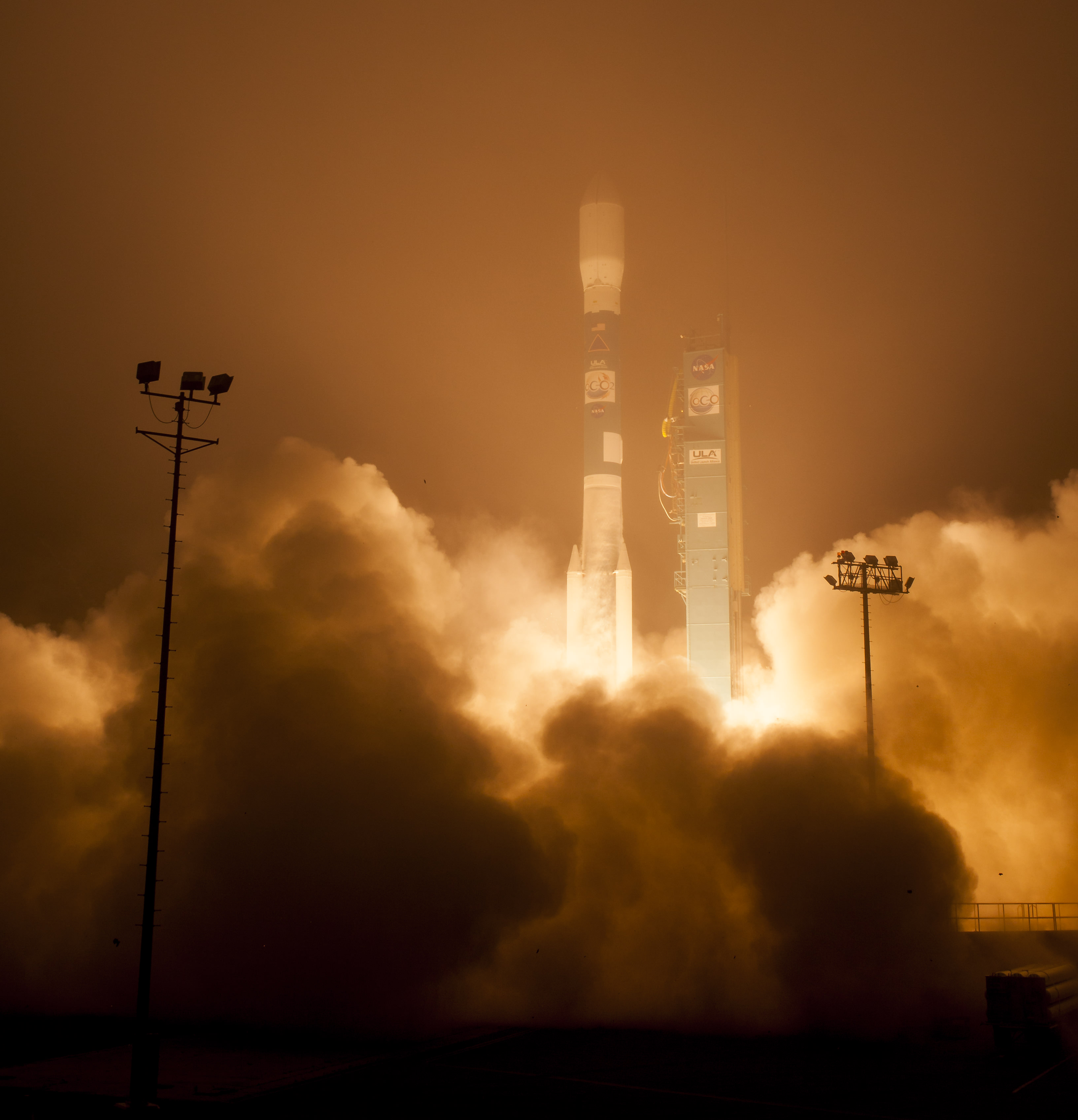
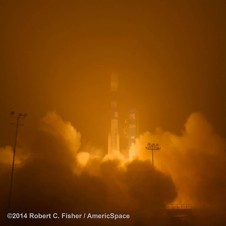
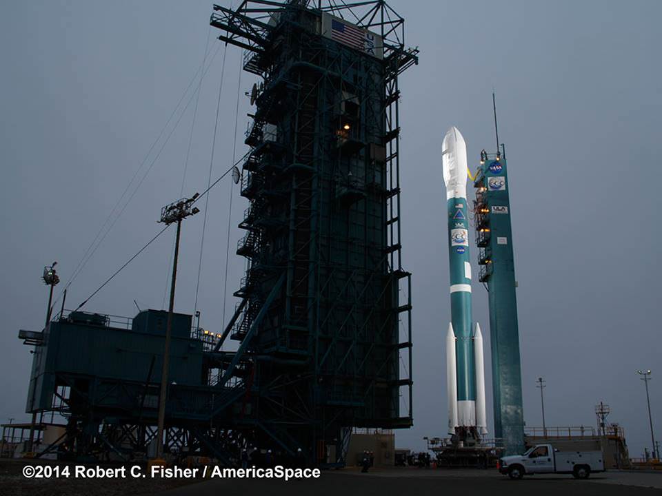
The Orbiting Carbon Observatory-2, NASA's first mission dedicated to studying carbon dioxide in Earth's atmosphere, lifts off from Vandenberg Air Force Base, California, at 2:56 a.m. Pacific Time, July 2, 2014 on a Delta II rocket. The two-year mission will help scientists unravel key mysteries about carbon dioxide. Credit: NASA/Bill Ingalls
The Orbiting Carbon Observatory-2, NASA’s first mission dedicated to studying carbon dioxide in Earth’s atmosphere, lifts off from Vandenberg Air Force Base, California, at 2:56 a.m. Pacific Time, July 2, 2014 on a Delta II rocket. The two-year mission will help scientists unravel key mysteries about carbon dioxide. Credit: NASA/Bill Ingalls
Story updated[/caption]
Following a nearly three-year long hiatus, the workhorse Delta II rocket successfully launched NASA’s first spacecraft dedicated to watching Earth breathe by studying Earth’s atmospheric carbon dioxide (CO2) – the leading human-produced greenhouse gas and the principal human-produced driver of climate change.
The Orbiting Carbon Observatory-2 (OCO-2) raced to orbit earlier this morning, during a spectacular nighttime blastoff at 2:56 a.m. PDT (5:56 a.m. EDT), Tuesday, July 2, 2014, from Vandenberg Air Force Base, California, atop a United Launch Alliance Delta II rocket.
The flawless launch marked the ‘return to flight’ of the venerable Delta II and was broadcast live on NASA TV.
Blastoff of NASA’s Orbiting Carbon Observatory-2 dedicated to studying carbon dioxide in Earth’s atmosphere, from Vandenberg Air Force Base, California, at 2:56 a.m. Pacific Time, July 2, 2014. Credit: Robert Fisher/America/Space
A camera mounted on the Delta II’s second stage captured a breathtaking live view of the OCO-2 spacecraft during separation from the upper stage, which propelled it into an initial 429-mile (690-kilometer) orbit.
The life giving solar arrays were unfurled soon thereafter and NASA reports that the observatory is in excellent health.
“Climate change is the challenge of our generation,” said NASA Administrator Charles Bolden in a statement.
“With OCO-2 and our existing fleet of satellites, NASA is uniquely qualified to take on the challenge of documenting and understanding these changes, predicting the ramifications, and sharing information about these changes for the benefit of society.”
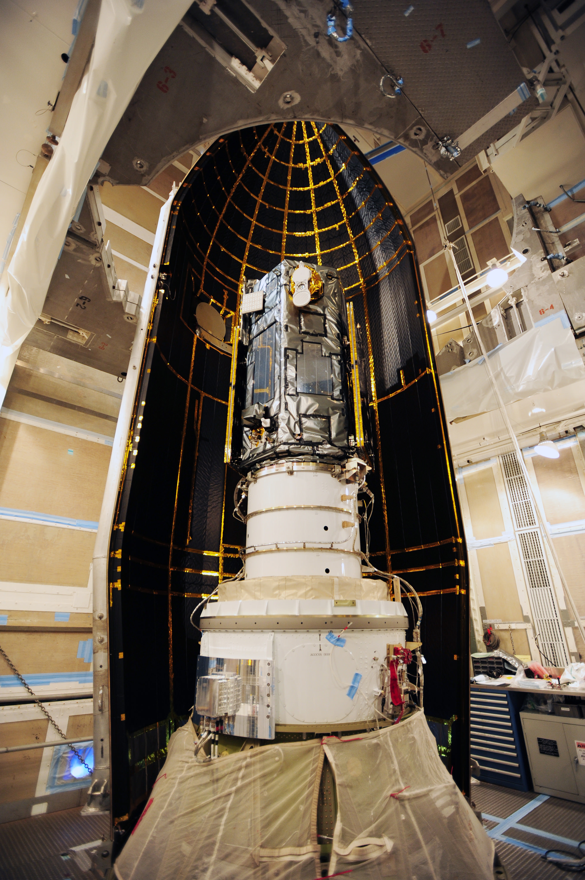
NASA’s Orbiting Carbon Observatory-2, or OCO-2, inside the payload fairing in the mobile service tower at Space Launch Complex 2 on Vandenberg Air Force Base in California. The fairing will protect OCO-2 during launch aboard a United Launch Alliance Delta II rocket, which occurred at 5:56 a.m. EDT on July 2. OCO-2 is NASA’s first mission dedicated to studying atmospheric carbon dioxide, the leading human-produced greenhouse gas driving changes in Earth’s climate. Credit: NASA/30th Space Wing USAF
Over the next three weeks the OCO-2 probe will undergo a thorough checkout and calibration process. It will also be maneuvered into a 438-mile (705-kilometer) altitude, near-polar orbit where it will become the lead science probe at the head of the international Afternoon Constellation, or “A-Train,” of Earth-observing satellites.
“The A-Train, the first multi-satellite, formation flying “super observatory” to record the health of Earth’s atmosphere and surface environment, collects an unprecedented quantity of nearly simultaneous climate and weather measurements,” says NASA.
Science operations begin in about 45 days.
The 999 pound (454 kilogram) observatory is the size of a phone booth.
OCO-2 is equipped with a single science instrument consisting of three high-resolution, near-infrared spec¬trometers fed by a common telescope. It will collect global measurements of atmospheric CO2 to provide scientists with a better idea of how CO2 impacts climate change and is responsible for Earth’s warming.
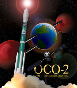
OCO-2 poster. Credit: ULA/NASA
During a minimum two-year mission the $467.7 million OCO-2 will take near global measurements to locate the sources and storage places, or ‘sinks’, for atmospheric carbon dioxide, which is a critical component of the planet’s carbon cycle.
OCO-2 was built by Orbital Sciences as a replacement for the original OCO which was destroyed during the failed launch of a Taurus XL rocket from Vandenberg back in February 2009 when the payload fairing failed to open properly and the spacecraft plunged into the ocean.
The OCO-2 mission will provide a global picture of the human and natural sources of carbon dioxide, as well as their “sinks,” the natural ocean and land processes by which carbon dioxide is pulled out of Earth’s atmosphere and stored, according to NASA.
“This challenging mission is both timely and important,” said Michael Freilich, director of the Earth Science Division of NASA’s Science Mission Directorate in Washington.
“OCO-2 will produce exquisitely precise measurements of atmospheric carbon dioxide concentrations near Earth’s surface, laying the foundation for informed policy decisions on how to adapt to and reduce future climate change.”
It will record around 100,000 precise individual CO2 measurements around the worlds entire sunlit hemisphere every day and help determine its source and fate in an effort to understand how human activities impact climate change and how we can mitigate its effects.
At the dawn of the Industrial Revolution, there were about 280 parts per million (ppm) of carbon dioxide in Earth’s atmosphere. As of today the CO2 level has risen to about 400 parts per million.
“Scientists currently don’t know exactly where and how Earth’s oceans and plants have absorbed more than half the carbon dioxide that human activities have emitted into our atmosphere since the beginning of the industrial era,” said David Crisp, OCO-2 science team leader at NASA’s Jet Propulsion Laboratory in Pasadena, California, in a statement.
“Because of this, we cannot predict precisely how these processes will operate in the future as climate changes. For society to better manage carbon dioxide levels in our atmosphere, we need to be able to measure the natural source and sink processes.”
OCO-2 is the second of NASA’s five new Earth science missions planned to launch in 2014 and is designed to operate for at least two years during its primary mission. It follows the successful blastoff of the joint NASA/JAXA Global Precipitation Measurement (GPM) Core Observatory satellite on Feb 27.
Prelaunch view of NASA’s Orbiting Carbon Observatory-2 and United Launch Alliance Delta II rocket unveiled at Space Launch Complex 2 at Vandenberg Air Force Base in California. Credit: Robert Fisher/America/Space
The two stage Delta II 7320-10 launch vehicle is 8 ft in diameter and approximately 128 ft tall and was equipped with a trio of first stage strap on solid rocket motors. This marked the 152nd Delta II launch overall and the 51st for NASA since 1989.
The last time a Delta II rocket flew was nearly three years ago in October 2011 from Vandenberg for the Suomi National Polar-Orbiting Partnership (NPP) weather satellite.
The next Delta II launch later this year from Vandenberg involves NASA’s Soil Moisture Active Passive (SMAP) mission and counts as another of NASA’s five Earth science missions launching in 2014.
Stay tuned here for Ken’s continuing OCO-2, GPM, Curiosity, Opportunity, Orion, SpaceX, Boeing, Orbital Sciences, MAVEN, MOM, Mars and more Earth & Planetary science and human spaceflight news.
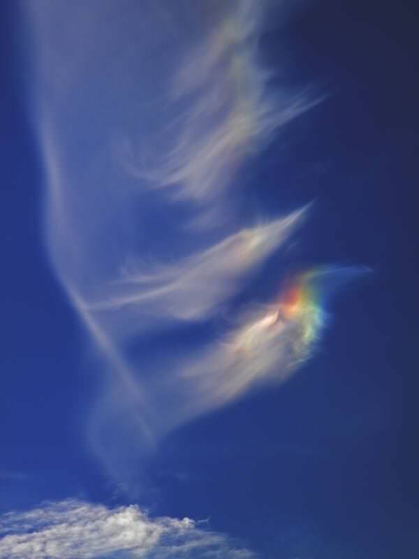
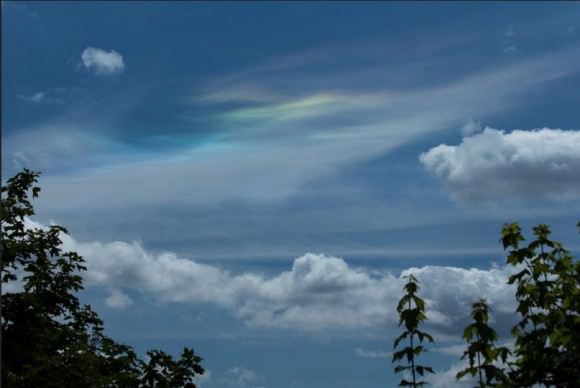
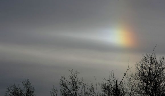
Ethereal and stunning sundog-like forms in the clouds over Oxford, England on June 25, 2014. Credit and copyright: Nathanial Burton-Bradford.
My Twitter feed exploded on June 25 with reports of colorful, crazy-looking clouds, sundogs, Sun halos and more. The above image from Nathanial Burton-Bradford is just an example of the type of atmospheric effect called a circumhorizontal arc. These are sometimes referred to as “fire rainbows” but of course are not rainbows, and fire plays no role.
This is an optical phenomenon from sunlight hitting ice crystals in high cirrus clouds. It is actually a rather rare occurrence, but it happens most often during the daytime in summer when the Sun is high in the sky. This creates a rainbow-type effect directly in the ice crystal-filled clouds.
See more examples below.
Wispy clouds and a circumhorizontal arc over Italy. Credit and copyright: Elisabetta Bonora.Circumhorizontal Arc over the UK on June 25, 2014. Credit and copyright: Sculptor Lil on Flickr.
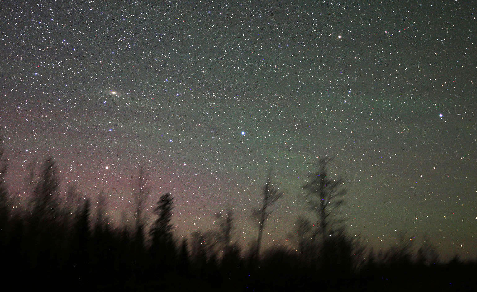
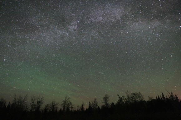
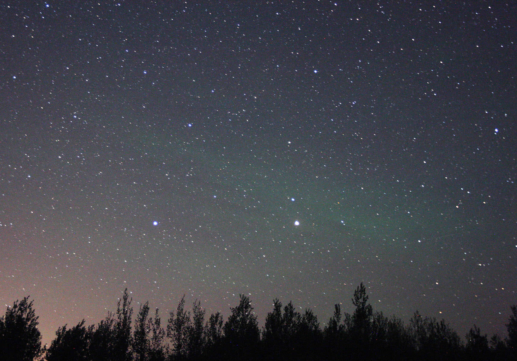
Airglow shows as wavy stripes of pale green across the northeastern sky on May 24, 2014. Andromeda Galaxy at left. the banding was faintly visible with the naked eye as a soft, diffuse glow. The red glow at lower left is airglow from atomic oxygen 90-185 miles up. Details: 20mm lens, ISO 3200, 30". Credit: Bob King
Emerald green, fainter than the zodiacal light and visible on dark nights everywhere on Earth, airglow pervades the night sky from equator to pole. Airglow turns up in our time exposure photographs of the night sky as ghostly ripples of aurora-like light about 10-15 degrees above the horizon. Its similarity to the aurora is no coincidence. Both form at around the same altitude of 60-65 miles (100 km) and involve excitation of atoms and molecules, in particular oxygen. But different mechanisms tease them to glow.
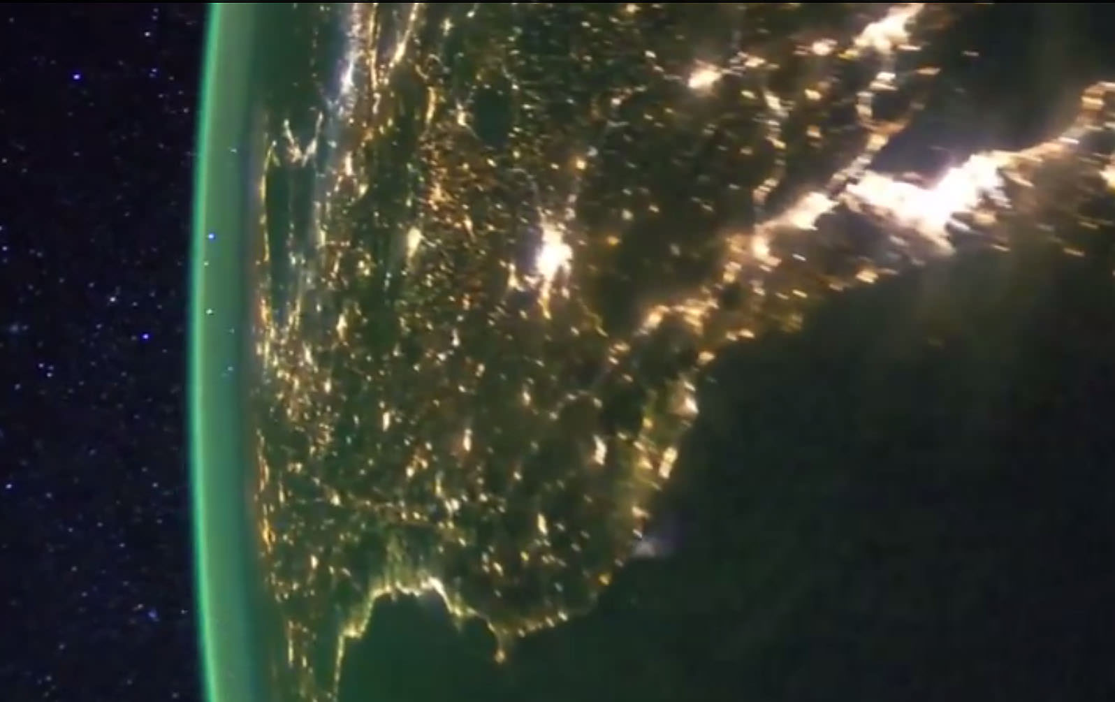
Earth at night from the International Space Station showing bright splashes of city lights and the airglow layer created by light-emitting oxygen atoms some 60 miles high in the atmosphere. This green cocoon of light is familiar to anyone who’s looked at photos of Earth’s night-side from orbit. Credit: NASA
Auroras get their spark from high-speed electrons and protons in the solar wind that bombard oxygen and nitrogen atoms and molecules. As excited electrons within those atoms return to their rest states, they emit photons of green and red light that create shimmering, colorful curtains of northern lights.
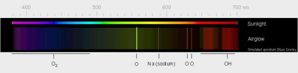
Green light from excited oxygen atoms dominates the light of airglow. The atoms are 56-62 miles high in the thermosphere. The weaker red light is from oxygen atoms further up. Sodium atoms, hydroxyl radicals (OH) and molecular oxygen add their own complement to the light. Credit: Les Cowley
Airglow’s subtle radiance arises from excitation of a different kind. Ultraviolet light from the daytime sun ionizes or knocks electrons off of oxygen and nitrogen atoms and molecules; at night the electrons recombine with their host atoms, releasing energy as light of different colors including green, red, yellow and blue. The brightest emission, the one responsible for creating the green streaks and bands visible from the ground and orbit, stems from excited oxygen atoms beaming light at 557.7 nanometers, smack in the middle of the yellow-green parcel of spectrum where our eyes are most sensitive.
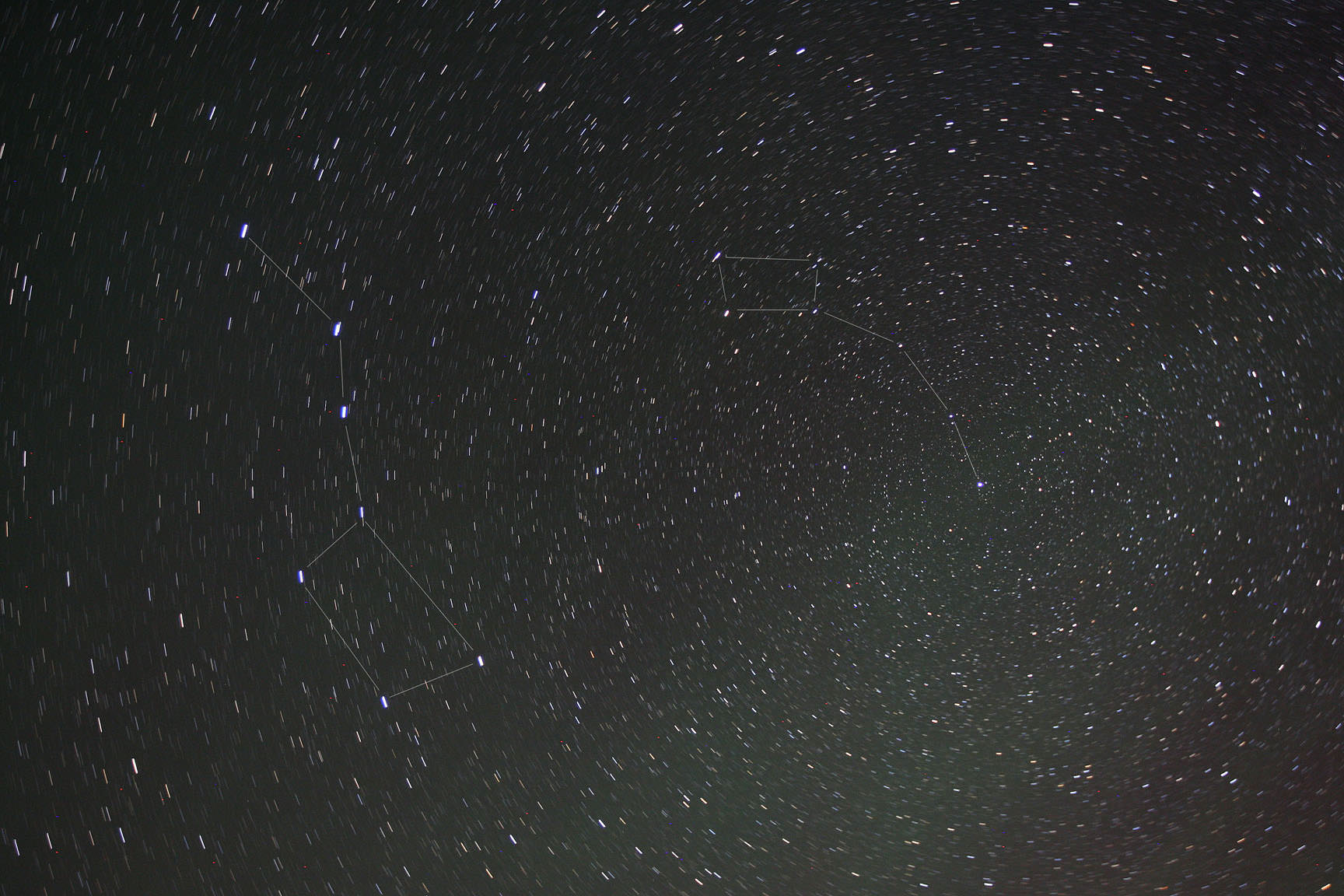
Airglow across the eastern sky below the summertime Milky Way. Notice that unlike the vertical rays and gently curving arcs of the aurora, airglow is banded, streaky and in places almost fibrous. It’s brightest and best visible 10-15 degrees high along a line of sight through the thicker atmosphere. If you look lower, its feeble light is absorbed by denser air and dust. Looking higher, the light spreads out over a greater area and appears dimmer. Credit: Bob KingA large, faint patch of airglow below the Dippers photographed May 24. To the eye, airglow appears as colorless streaks and patches. Unlike the aurora, it’s typically too faint to excite our color vision. Time exposures show its colors well. This swatch is especially faint because it’s much higher above the horizon. Credit: Bob King
That’s not saying airglow is easy to see! For years I suspected streaks of what I thought were high clouds from my dark sky observing site even when maps and forecasts indicated pristine skies. Photography finally taught me to trust my eyes. I started noticing green streaks near the horizon in long-exposure astrophotos. At first I brushed it off as camera noise. Then I noticed how the ghostly stuff would slowly shape-shift over minutes and hours and from night to night. Gravity waves created by jet stream shear, wind flowing over mountain ranges and even thunderstorms in the lower atmosphere propagate up to the thermosphere to fashion airglow’s ever-changing contours.
An obvious airglow smear across Virgo last month. Mars is the bright object below and right of center. Light pollution from Duluth, Minn. creeps in at lower left. Credit: Bob King
Last month, on a particularly dark night, I made a dedicated sweep of the sky after my eyes had fully adapted to the darkness. A large swath of airglow spread south of the Big and Little Dipper. To the east, Pegasus and Andromeda harbored hazy spots of varying intensity, while brilliant Mars beamed through a long smear in Virgo.
To prove what I saw was real, I made the photos you see in this article and found they exactly matched my visual sightings. Except for color. Airglow is typically too faint to fire up the cone cells in our retinas responsible for color vision. The vague streaks and patches were best seen by moving your head around to pick out the contrast between them and the darker, airglow-free sky. No matter what part of the sky I looked, airglow poked its tenuous head. Indeed, if you were to travel anywhere on Earth, airglow would be your constant companion on dark nights, unlike the aurora which keeps to the polar regions. Warning – once you start seeing it, you
Excited oxygen at higher altitude creates a layer of faint red airglow. Sodium excitation forms the yellow layer at 57 miles up. Airglow is brightest during daylight hours but invisible against the sunlight sky. Credit: NASA with annotations by Alex Rivest
Airglow comes in different colors – let’s take a closer look at what causes them:
* Red – I’ve never seen it, but long-exposure photos often reveal red/pink mingled with the more common green. Excited oxygen atoms much higher up at 90-185 miles (150-300 km) radiating light at a different energy state are responsible. Excited -OH (hydroxyl) radicals give off deep red light in a process called chemoluminescencewhen they react with oxygen and nitrogen. Another chemoluminescent reaction takes place when oxygen and nitrogen molecules are busted apart by ultraviolet light high in the atmosphere and recombine to form nitric oxide (NO).
* Yellow – From sodium atoms around 57 miles (92 km) high. Sodium arrives from the breakup and vaporization of minerals in meteoroids as they burn up in the atmosphere as meteors.
* Blue – Weak emission from excited oxygen molecules approximately 59 miles (95 km) high.
Comet Lovejoy passing behind green oxygen and sodium airglow layers on December 22, 2011 seen from the space station. Credit: NASA/Dan Burbank
Airglow varies time of day and night and season, reaching peak brightness about 10 degrees, where our line of sight passes through more air compared to the zenith where the light reaches minimum brightness. Since airglow is brightest around the time of solar maximum (about now), now is an ideal time to watch for it. Even cosmic rays striking molecules in the upper atmosphere make a contribution.
See lots of airglow and aurora from orbit in this video made using images taken from the space station.
If you removed the stars, the band of the Milky Way and the zodiacal light, airglow would still provide enough illumination to see your hand in front of your face at night. Through recombination and chemoluminescence, atoms and molecules creates an astounding array of colored light phenomena. We can’t escape the sun even on the darkest of nights.
Aurorae were once believed to be warring clans of spirit soldiers, the skyward ghosts of virgin women, or the glow of fires burning inside celestial caves. Today we know they’re caused by ions in the atmosphere getting zapped by charged solar particles caught up in Earth’s magnetic field. But the knowledge of what creates aurorae doesn’t make their shimmering dance any less beautiful for those lucky enough to see them. I’ve personally never witnessed an aurora, but photographer Ole Salomonsen has — and he’s created yet another gorgeous time-lapse of the northern lights over his native Scandinavia to share their beauty with the world.
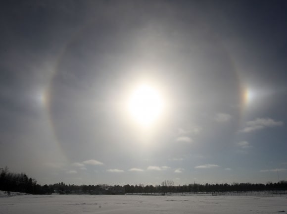
A circumscribed halo encloses the more common 22-degree halo around the sun Saturday morning (May 17. Credit: Bob King
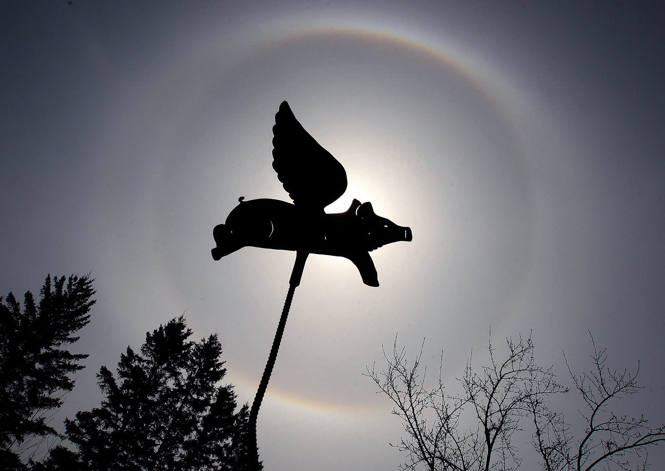
Call it a porcine occultation. It took nearly a year but I finally got help from the ornamental pig in my wife’s flower garden. This weekend it became the preferred method for blocking the sun to better see and photograph a beautiful pair of solar halos. We often associate solar and lunar halos with winter because they require ice crystals for their formation, but they happen during all seasons.
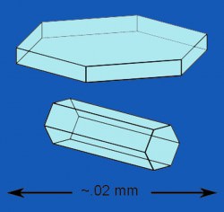
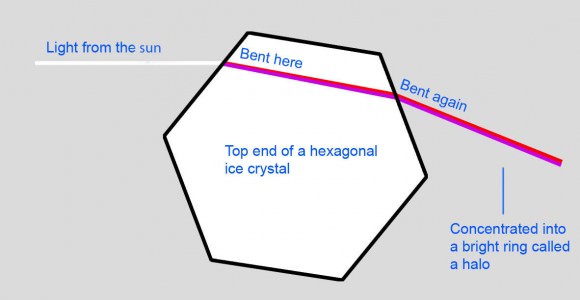
Nature keeps it simple. Light refracting through or reflecting from six-sided plate and column (pencil-shaped) ice crystals in high clouds is responsible for almost all halos and their variations.
Lower clouds, like the puffy cumulus dotting the sky on a summer day, are composed of water droplets. A typical cumulus spans about a kilometer and contains 1.1 million pounds of water. Cirrostratus clouds are much higher (18,000 feet and up) and colder and formed instead of ice crystals. They’re often the first clouds to betray an incoming frontal system.
Cirrostratus are thin and fibrous and give the blue sky a milky look. Most halos and related phenomena originate in countless millions of hexagonal plate and pencil-shaped ice crystals wafting about like diamond dust in these often featureless clouds.
This is the top end of a hexagonal column-shaped ice crystal. Light refracting (bending) through the 60-degree angled faces of millions of these crystals is concentrated into a ring of light 22 degrees from the sun. As light leaves the crystal, the shorter blue and purple wavelengths are refracted slightly more than red, tinting the outer edge of the halo blue and inner edge red. Credit: Donalbein with additions by the author
In winter, the sun is generally low in the sky, making it hard to miss a halo. Come summer, when the sun is much higher up, halo spotters have to be more deliberate and make a point to look up more often. The 22-degree halo is the most common; it’s the inner of the two halos in the photo above. With a radius of 22 degrees, an outstretched hand at arm’s length will comfortably fit between sun and circle.
Light refracted or bent through millions of randomly oriented pencil-shaped crystals exits at angles from 22 degrees up to 50 degrees, however most of the light is concentrated around 22 degrees, resulting in the familiar 22-degree radius halo. No light gets bent and concentrated at angles fewer than 22 degrees, which is why the sky looks darker inside the halo than outside. Finally, a small fraction of the light exits the crystals between 22 and 50 degrees creating a soft outer edge to the circle as well as a large, more diffuse disk of light as far as 50 degrees from the sun.
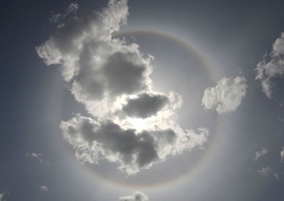
The sun on Dec. 6, 2013 with a 22-degree halo and two luminous canine companions or sundogs. Similar halos and ‘moondogs’ can be seen around a bright moon. Credit: Bob King
Sundogs, also called mock suns or parhelia, are brilliant and often colorful patches of light that accompany the sun on either side of a halo. Not as frequent as halos, they’re still common enough to spot half a dozen times or more a year. Depending on how extensive the cloud cover is, you might see only one sundog instead of the more typical pair. Sundogs form when light refracts through hexagonal plate-shaped ice crystals with their flat sides parallel to the ground. They appear when the sun is near the horizon and on the same horizontal plane as the ice crystals. As in halos, red light is refracted less than blue, coloring the dog’s ‘head’ red and its hind quarters blue. Mock sun is an apt term as occasionally a sundog will shine with the intensity of a second sun. They’re responsible for some of the daytime ‘UFO’ sightings. Check this one one out on YouTube.
An especially colorful sundog with a ‘tail’. Red light is bent less than blue as it emerges from the ice crystal, tinting the sundog’s inner edge. Blue is bent more and colors the outer half. If you look closely, all colors of the rainbow are seen. Credit: Bob King
Wobbly crystals make for taller sundogs. Like real dogs, ice crystal sundogs can grow tails. These are part of the much larger parhelic circle, a rarely-seen narrow band of light encircling the entire sky at the sun’s altitude formed when millions of both plate and column crystals reflect light from their vertical faces. Short tails extend from each mock sun in the photo above.
About 2 hours after the flying pig image, the sun climbed beyond 50 degrees altitude. The circumscribed halo vanished! Credit: Bob King
There’s almost no end to atmospheric ice antics. Many are rare like the giant 46-degree halo or the 9 and 18-degree halos formed from pyramidal ice crystals. Oftentimes halos are accompanied by arcs or modified arcs as in the flying pig image. When the sun is low, you’ll occasionally see an arc shaped like a bird in flight tangent to the top of the halo and rarely, to its bottom. When the sun reaches an altitude of 29 degrees, these tangent arcs – both upper and lower – change shape and merge into a circumscribed halowrapped around and overlapping the top and bottom of the main halo. At 50 degrees altitude and beyond, the circumscribed halo disappears … for a time. If the clouds persist, you can watch it return when the sun dips below 29 degrees and the two arcs separate again.
Maybe you’re not a halo watcher, but anyone who keeps an eye on the weather and studies the daytime sky in preparation for a night of skywatching can enjoy these icy appetizers.
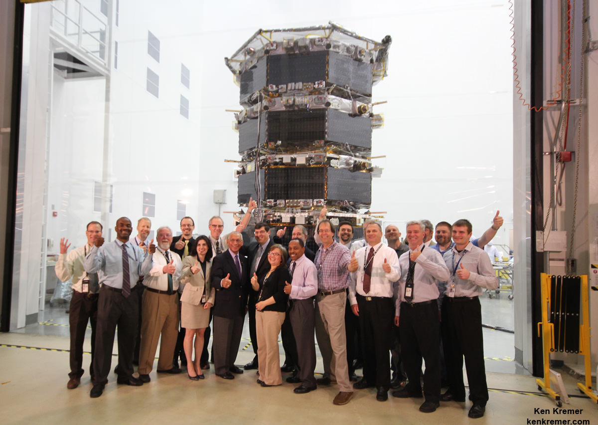
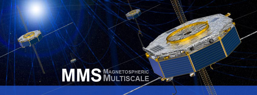
NASA Administrator Charles Bolden poses with the agency’s Magnetospheric Multiscale (MMS) spacecraft, mission personnel, Goddard Center Director Chris Scolese and NASA Associate Administrator John Grunsfeld, during visit to the cleanroom at NASA's Goddard Space Flight Center in Greenbelt, Md., on May 12, 2014. Credit: Ken Kremer- kenkremer.com
NASA Administrator Charles Bolden poses with the agency’s Magnetospheric Multiscale (MMS) spacecraft, mission personnel, Goddard Center Director Chris Scolese and NASA Associate Administrator John Grunsfeld, during visit to the cleanroom at NASA’s Goddard Space Flight Center in Greenbelt, Md., on May 12, 2014. Credit: Ken Kremer- kenkremer.com
Story updated[/caption]
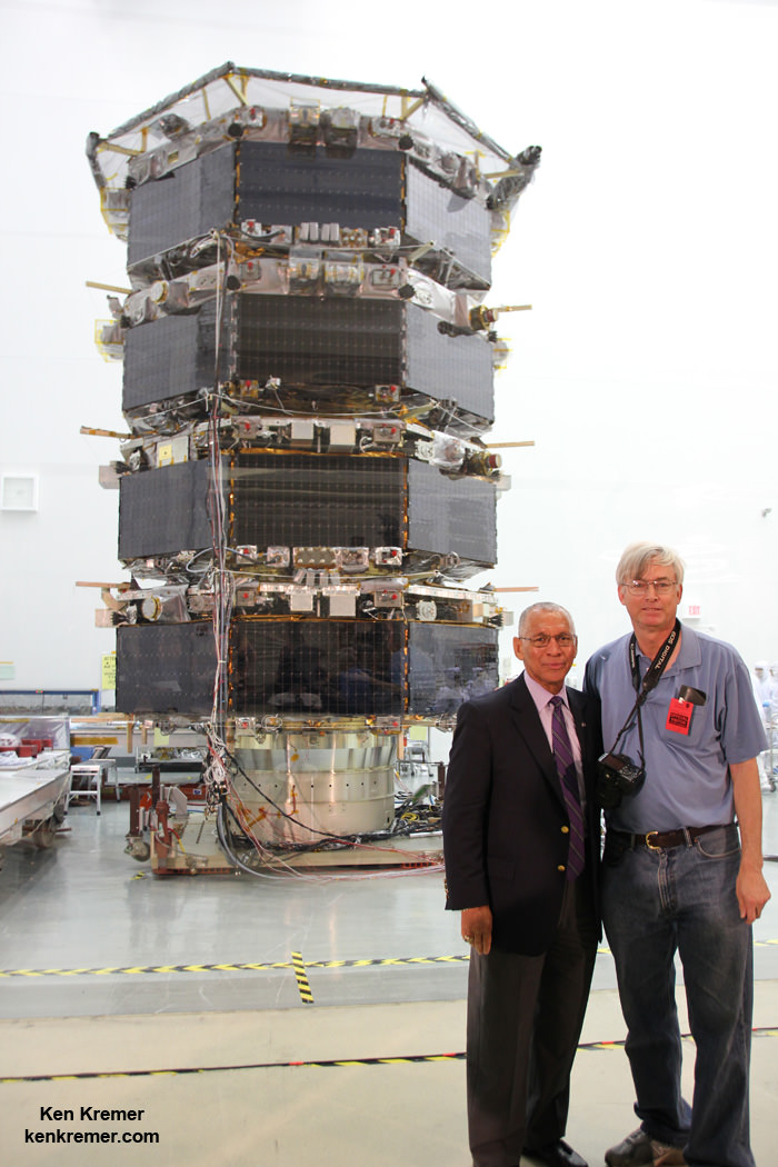
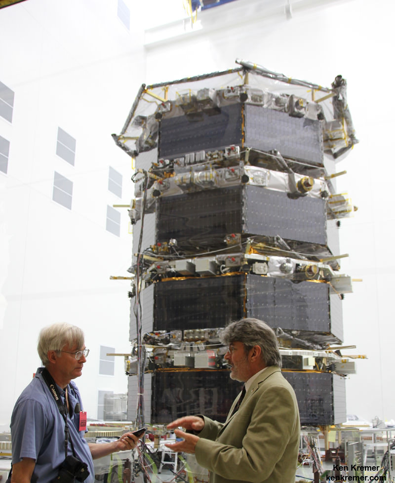
NASA GODDARD SPACE FLIGHT CENTER, MD – NASA’s upcoming Magnetospheric Multiscale (MMS) mission is comprised of a quartet of identically instrumented observatories aimed at providing the first three-dimensional views of a fundamental process in nature known as magnetic reconnection. They were unveiled to greet NASA Administrator Charles Bolden on Monday, May 12, in a rare fully stacked arrangement inside the Goddard cleanroom.
Universe Today was on hand with NASA Administrator Bolden, Science Mission Chief John Grunsfeld and the MMS mission team at Goddard for a first hand inspection and up close look at the 20 foot tall, four spacecraft stacked configuration in the cleanroom and for briefings about the projects fundamental science goals.
“I’m visiting with the MMS team today to find out the status of this mission scheduled to fly early in 2015. It’s one of many projects here at Goddard,” NASA Administrator Bolden told me in an exclusive one-on-one interview at the MMS cleanroom.
“MMS will help us study the phenomena known as magnetic reconnection and help us understand how energy from the sun – magnetic and otherwise – affects our own life here on Earth. MMS will study what effects that process … and how the magnetosphere protects Earth.”
Magnetic reconnection is the process whereby magnetic fields around Earth connect and disconnect while explosively releasing vast amounts of energy.
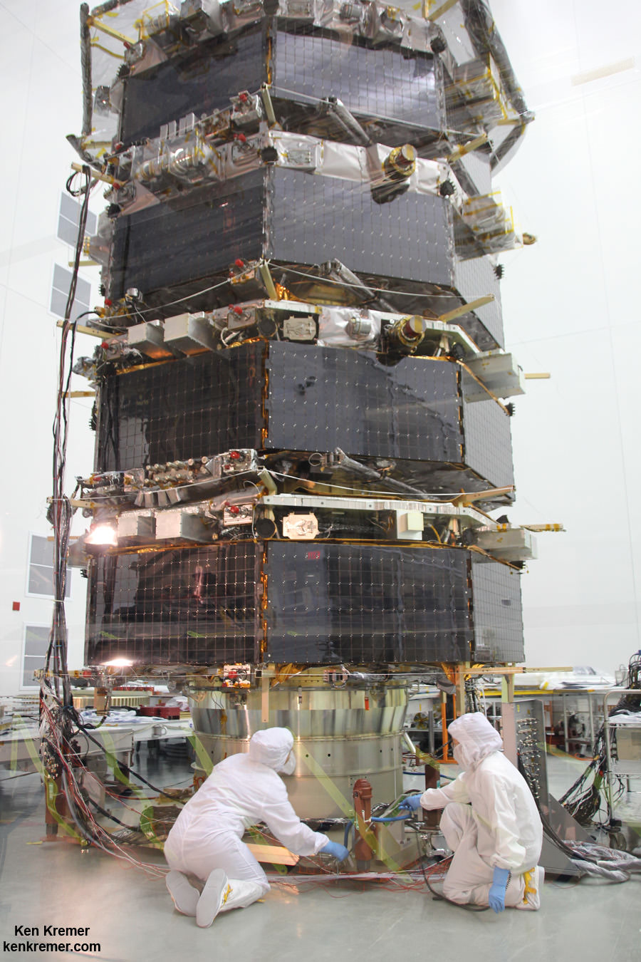
Technicians work on NASA’s 20-foot-tall Magnetospheric Multiscale (MMS) mated quartet of stacked observatories in the cleanroom at NASA’s Goddard Space Flight Center in Greenbelt, Md., on May 12, 2014. Credit: Ken Kremer- kenkremer.com
MMS measurements should lead to significant improvements in models for yielding better predictions of space weather and thereby the resulting impacts for life here on Earth as well as for humans aboard the ISS and robotic satellite explorers in orbit and the heavens beyond.
The four identical spacecraft – which are still undergoing testing – were stacked in a rarely seen launch arrangement known affectionately as the “IHOP configuration” – because they look rather like a stack of luscious pancakes.
“MMS is a fundamental heliophysics science mission,” Craig Tooley told me at the MMS cleanroom. Tooley is MMS project manager at NASA Goddard.
“Unlike Hubble that uses remote sensing, MMS is like a flying laboratory ‘in situ’ that will capture events that are the major energy transfer from the sun’s magnetic field into our Earth’s space weather environment and magnetosphere.”
“These are called magnetic reconnection events that pump enormous amounts of energy into the plasma and the fields around Earth. It’s one of the main drivers of space weather and a fundamental physical process that is not very well understood,” Tooley explained.
“The spacecraft were built in-house here at Goddard and just completed vibration testing.”
MMS will launch atop an Atlas V rocket in March 2015 from Space launch Complex 41, Cape Canaveral Air Force Station, Florida.
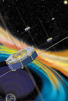
Artist rendition of the four MMS spacecraft in orbit in Earth’s magnetic field. Credit: NASA
The vibration testing is a major milestone and is conducted to ensure the spacecraft can withstand the most extreme vibration and dynamic loads they will experience and which occurs during liftoff inside the fairing of the Atlas V booster.
MMS is also another highly valuable NASA science mission (along with MAVEN, LADEE and others) which suffered launch delays and increased costs as a result of the US government shutdown last October 2013, Bolden confirmed to Universe Today.
“We ended up slipping beyond the original October 2014 date due to the government shutdown and [the team] being out of work for a couple of weeks. MMS is now scheduled to launch in March 2015,” Bolden told me.
“So then you are at the mercy of the launch provider.”
“The downside to slipping that far is that’s its [MMS] costing more to launch,” Bolden stated.
Each of the Earth orbiting spacecraft is outfitted with 25 science sensors to study the microphysics of three fundamental plasma processes: magnetic reconnection, energetic particle acceleration, and turbulence.
Magnetic reconnection occurs throughout our universe.
“The primary mission will last two years,” Tooley told me.
“Each spacecraft carries about 400 kilograms of fuel. There is a possibility to extend the mission by about a year based on fuel consumption.”
NASA Administrator Charles Bolden and Ken Kremer (Universe Today) inspect NASA’s Magnetospheric Multiscale (MMS) mated quartet of stacked spacecraft at the cleanroom at NASA’s Goddard Space Flight Center in Greenbelt, Md., on May 12, 2014. Credit: Ken Kremer- kenkremer.com
The spacecraft will use the Earth itself as a laboratory to unlock the mysteries of magnetic reconnection – the primary process that transfers energy from the solar wind into Earth’s magnetosphere and is responsible for geomagnetic storms.
“To understand the fundamental physics, they will fly in a pyramid-like formation and capture the magnetic reconnection events in 3-D by flying through them as they happen – that’s why we have 4 spacecraft,” Tooley explained.
“Initially they will be spaced apart by about 10 to 30 kilometers while they fly in a tetrahedron formation and scan with their booms spread out – depending on what the scientists says is the optimal configuration.”
“They fly in a highly elliptical orbit between about 7,000 and 75,000 kilometers altitude during the first half of the mission. Eventually the orbit will be extended out to about 150,000 kilometers.”
The best place to study magnetic reconnection is ‘in situ’ in Earth’s magnetosphere.
This will lead to better predictions of space weather phenomena.
Magnetic reconnection is also believed to help trigger the spectacular aurora known as the Northern or Southern lights.
Stay tuned here for Ken’s continuing MMS, Curiosity, Opportunity, SpaceX, Orbital Sciences, Boeing, Orion, LADEE, MAVEN, MOM, Mars and more planetary and human spaceflight news.
Ken’s upcoming presentation: Mercy College, NY, May 19: “Curiosity and the Search for Life on Mars” and “NASA’s Future Crewed Spaceships.”
MMS Project Manager Craig Tooley (right) and Ken Kremer (Universe Today) discuss science objectives of NASA’s upcoming Magnetospheric Multiscale mission by 20 foot tall mated quartet of stacked spacecraft at the cleanroom at NASA’s Goddard Space Flight Center in Greenbelt, Md., on May 12, 2014. Credit: Ken Kremer- kenkremer.com
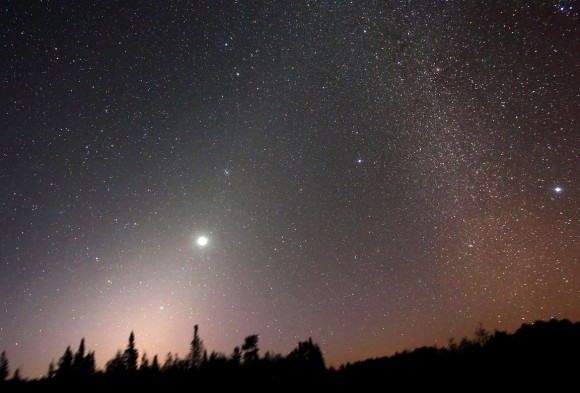
The zodiacal light (left) reaches up from the eastern horizon to "touch" the Milky Way at right on Sept. 23, 2012. Credit: Bob King
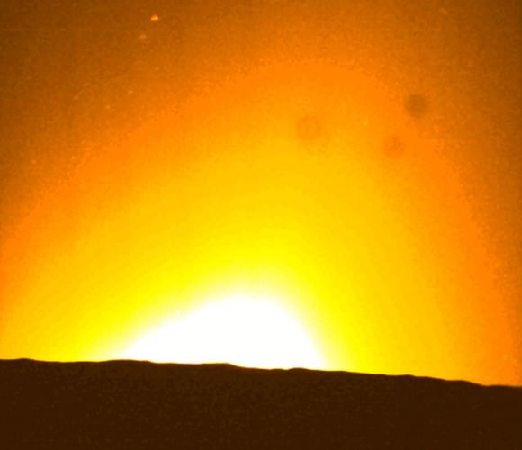
Sunrise over the surface of the moon: a series of star tracker images taken by LADEE Saturday, April 12. The lunar horizon is ahead, a few minutes before orbital sunrise. Image Credit: NASA Ames.
[/caption]
NASA’s Lunar Atmosphere and Dust Environment Explorer (LADEE) literally ‘saw the light’ just days before crashing into the lunar farside last Thursday April 17. Skimming just a few kilometers above the moon’s surface, mission controllers took advantage of this unique low angle to gaze out over the moon’s horizon in complete darkness much like the Apollo astronauts did from lunar orbit more than 40 years ago.
The zodiacal light (left), adorned by the planet Venus, reaches up from the eastern horizon to “touch” the Milky Way before sunrise on Sept. 23, 2012. Credit: Bob King
With the glow of Earth well-hidden, any dust in the moon’s scant atmosphere around the time of orbital sunrise should become visible. Scientists also expected to see the softly luminous glow of the zodiacal light, an extensive cloud of comet and asteroid dust concentrated in the flat plane of the solar system. The zodiacal light gets its name from the zodiac, that familiar band of constellations the planets pass through as they orbit the sun. Back on Earth, the zodiacal light looks like a big thumb of light standing up from the western horizon a couple hours after sunset in spring and before sunrise in fall.
Frame from LADEE’s star tracker camera showing the zodiacal light rising on the moon’s horizon from its extremely low orbit on April 12, 2014. Credit: NASA
So what did LADEE see? As you watch the animation above, comprised of images taken from darkness until sunrise, you’ll see a yellow haze on the horizon that expands into large diffuse glow tilted slightly to the right. This is the zodiacal light along with a smaller measure of light coming from sun’s outer atmosphere or corona. Together they’re referred to as CZL or ‘coronal and zodiacal light’. At the very end, the sun peaks over the lunar horizon.
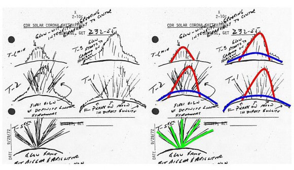
This is a sketch of the lunar sunrise seen from orbit by Apollo 17 astronaut Eugene Cernan. On the right, the sketches are highlighted in color to show the sources of the scattered light: red indicates coronal and zodiacal light (CZL), blue is a glow along the lunar horizon possibly caused by dust suspended in the moon’s exosphere, and green may be crepuscular rays formed by shadowing and scattered light. Credit: NASA/phys.org
What appears to be missing from the pictures are the mysterious rays seen by some of the Apollo astronauts. The rays, neatly sketched by astronaut Eugene Cernan of Apollo 17, look a lot like those beams of light and shadow streaming though holes in clouds called crepuscular rays.
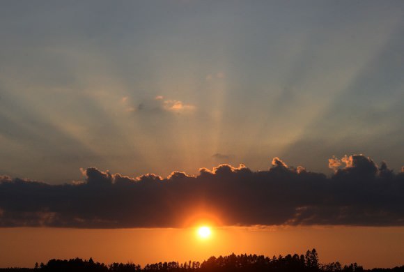
Crepuscular rays form a crown of rays made of alternating shadows and light scattered by dust and moisture in the atmosphere. Credit: Bob King
Only thing is, Earth’s atmosphere is thick enough for cloud beams. The dust in the moon’s atmosphere appears much too thin to cause the same phenomenon. And yet the astronauts saw rays as if sunlight streamed between mountain peaks and scattered off the dust just like home.
Low level horizon glow photos on the moon captured by the Surveyor 7 unmanned lander in 1968. It’s possible this low altitude glow is caused by larger dust particles that don’t travel as high as the smaller motes. Credit: NASA
It’s believed that dust gets lofted into the spare lunar atmosphere via electricity. Ultraviolet light from the sun knocks electrons from atoms in moon dust, giving them a positive charge. Since like charges repel, bits of dust push away from one another and move in the direction of least resistance: up. The smaller the dust particle, the higher it rises until dropping back down to the surface. Perhaps these “fountains” of lunar dust illuminated by the sun are what the astronauts recorded.
Unlike Cernan, LADEE saw only the expected coronal and zodiacal light but no rays. Scientists plan to look more closely at several sequences of images made of lunar sunrise in hopes of finding them.