[/caption]
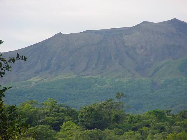
Rincon de la Vieja is an active andesitic complex volcano in Costa Rica, located about 25 km from the city of Liberia. The main summit of the volcano complex stands 1916 meters above sea level, and it’s protected in the Rincon de la Vieja Volcano National Park. It’s one of 7 active volcanoes in Costa Rica. Another name for Rincon de la Vieja is the “Colossus of Guanacaste”.
Seen from the air, Rincon del la Vieja is clearly an active volcano. There are a total of 9 major eruptive centers. You can see several large craters, with the youngest craters located in the southeast region. The last major magmatic eruption in the region happened about 3,500 years ago when about 0.25 cubic km of material was released in a plinian eruption. All the rest of the eruptions have come from the prominent crater that contains a 500-meter-wide acid lake.
There have been a total of 16 major eruptions since historical records began. The most recent event was in February, 1998, but for most of the time, the volcano just spews gasses and ash.
There are many hot bools and bubbling mud on the slopes of the volcano, and these just add to the reasons tourists visit the park. Hikers can climb up the crater, birdwatch, go river rafting, and do many other activities. Climbing to the top of Rincon del la Vieja volcano is an 8 km hike through two types of forest. The last 2 km is up a 50-degree slope. There are several lodges and hotels in the area for tourists.
We have written many articles about volcanoes for Universe Today. Here’s an article about many famous volcanoes, and here’s an article about another volcano in Costa Rica, Arenal.
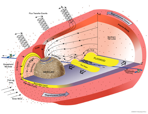
Compared to Earth, Mercury doesn’t have much of an atmosphere. The smallest rocky planet has weak surface gravity, only 38% that of Earth. And the scorching-hot daytime surface temperatures of 800 degrees Fahrenheit (approximately 450 degrees Celsius) should have boiled away any trace of Mercury’s atmosphere long ago. Yet recent flybys of the MESSENGER spacecraft clearly revealed Mercury somehow retains a thin layer of gas near its surface. Where does this atmosphere come from?
“Mercury’s atmosphere is so thin, it would have vanished long ago unless something was replenishing it,” says Dr. James A. Slavin of NASA’s Goddard Space Flight Center, Greenbelt, Md., a co-investigator on NASA’s MESSENGER mission to Mercury.
The solar wind may well be the culprit. A thin gas of electrically charged particles called a plasma, the solar wind blows constantly from the surface of the sun at some 250 to 370 miles per second (about 400 to 600 kilometers/second). According to Slavin, that’s fast enough to blast off the surface of Mercury through a process called “sputtering”, according to Slavin. Some sputtered atoms stay close enough to the surface to serve as a tenuous yet measurable atmosphere.
But there’s a catch – Mercury’s magnetic field gets in the way. MESSENGER’s first flyby on January 14, 2008, confirmed that the planet has a global magnetic field, as first discovered by the Mariner 10 spacecraft during its flybys of the planet in 1974 and 1975. Just as on Earth, the magnetic field should deflect charged particles away from the planet’s surface. However, global magnetic fields are leaky shields and, under the right conditions, they are known to develop holes through which the solar wind can hit the surface.
During its second flyby of the planet on October 6, 2008, MESSENGER discovered that Mercury’s magnetic field can be extremely leaky indeed. The spacecraft encountered magnetic “tornadoes” – twisted bundles of magnetic fields connecting the planetary magnetic field to interplanetary space – that were up to 500 miles wide or a third of the radius of the planet.
“These ‘tornadoes’ form when magnetic fields carried by the solar wind connect to Mercury’s magnetic field,” said Slavin. “As the solar wind blows past Mercury’s field, these joined magnetic fields are carried with it and twist up into vortex-like structures. These twisted magnetic flux tubes, technically known as flux transfer events, form open windows in the planet’s magnetic shield through which the solar wind may enter and directly impact Mercury’s surface.”
Venus, Earth, and even Mars have thick atmospheres compared to Mercury, so the solar wind never makes it to the surface of these planets, even if there is no global magnetic field in the way, as is the case for Venus and Mars. Instead, it hits the upper atmosphere of these worlds, where it has the opposite effect to that on Mercury, gradually stripping away atmospheric gas as it blows by.
The process of linking interplanetary and planetary magnetic fields, called magnetic reconnection, is common throughout the cosmos. It occurs in Earth’s magnetic field, where it generates magnetic tornadoes as well. However, the MESSENGER observations show the reconnection rate is ten times higher at Mercury.
“Mercury’s proximity to the sun only accounts for about a third of the reconnection rate we see,” said Slavin. “It will be exciting to see what’s special about Mercury to explain the rest. We’ll get more clues from MESSENGER’s third flyby on September 29, 2009, and when we get into orbit in March 2011.”
Slavin’s MESSENGER research was funded by NASA and is the subject of a paper that appeared in the journal Science on May 1, 2009.
MESSENGER (MErcury Surface, Space ENvironment, GEochemistry, and Ranging) is a NASA-sponsored scientific investigation of the planet Mercury and the first space mission designed to orbit the planet closest to the Sun. The MESSENGER spacecraft launched on August 3, 2004, and after flybys of Earth, Venus, and Mercury will start a yearlong study of its target planet in March 2011. Dr. Sean C. Solomon, of the Carnegie Institution of Washington, leads the mission as Principal Investigator. The Johns Hopkins University Applied Physics Laboratory, Laurel, Md., built and operates the MESSENGER spacecraft and manages this Discovery-class mission for NASA.
[/caption]
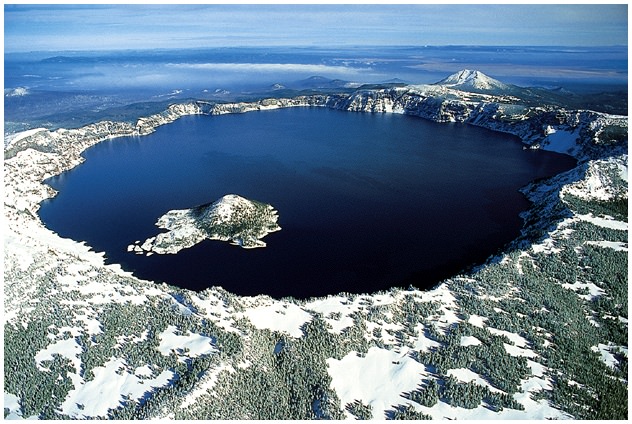
It’s not a mountain any more, but geologists refer to Mount Mazama as a peak in Oregon that used to exist before a catastrophic eruption destroyed the entire mountain and collapsed it into a giant caldera. The water-filled caldera is known Crater Lake, the deepest lake in the United States.
Mount Mazama started growing about 400,000 years ago, and it was made up of lava flows mixed with pyroclastic material. After that base was created, it switched to more explosive eruptions about 75,000 years ago. Then Mount Mazama started cone building eruptions until about 50,000 years ago. At its largest point, Mazama’s peak probably had an elevation of 3,400 meters.
Mazama started its devastating eruptions around 5677 BC with a large release of ash and pyroclastic flows. But the most devastating eruption happened 1-200 years later, when almost 60 cubic kilometers of magma was ejected out of the volcano. This emptied the magma chamber beneath the mountain, and caused it to collapse into a deep caldera. This is why Crater Lake is so deep.
Hundreds of square kilometers around the mountain were destroyed by ejected ash and deadly pyroclastic flows. One flow reached a point 64 km away down the Rogue River Valley. Ash from the explosion settled over a 1.3 million square km region of what is now the United States and Canada.
Geologists believe that there will be more volcanic activity in the future. Lava will probably make Crater Lake more shallow and eventually divide it into multiple lakes. But Mount Mazama probably won’t ever reform at the same size and structure before its detonation.
The name for Mount Mazama came from a climbing club from Portland. The were the Mazamas, and named the missing mountain after their group.
We have written many articles about volcanoes for Universe Today. Here’s a list of some of the most famous volcanoes in the world, and here’s an article about nearby Mount St. Helens.
[/caption]
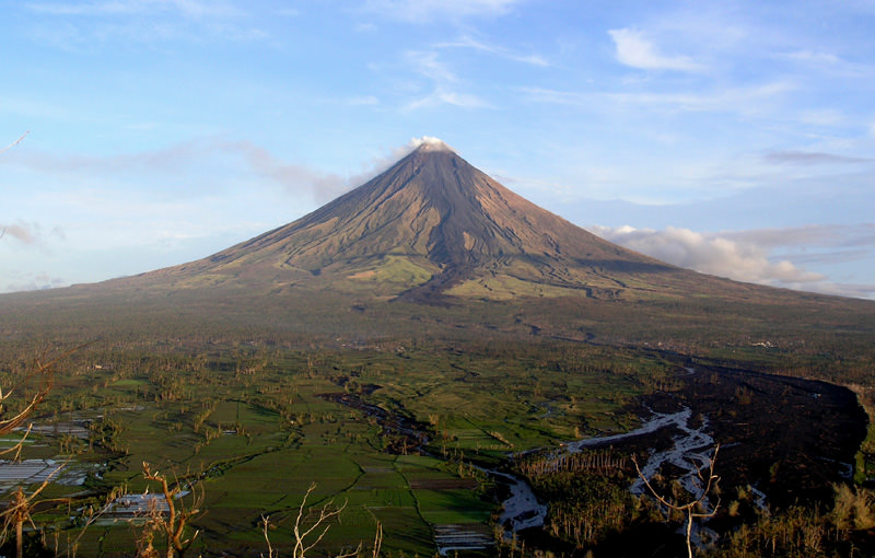
Mount Mayon, also known as the Mayon Volcano is an active stratovolcano on the island of Luzon in the Philippines. It’s located about 15 kilometers northwest of Legazpi City. Its current elevation is 2,463 meters.
This volcano is located on a convergent boundary between the Eurasian and Philippine Plate. The lighter continental plate floats over top of the oceanic plate, forcing it down, and allowing magma to well up from the Earth’s interior. This makes Mayon a very active volcano; in fact, it’s the most active volcano in the Philippines, having erupted 47 times in the last 400 years. The first recorded eruption was in 1616, and the last major eruption was on October 1st, 2006.
The most devastating eruption happened on February 1, 1814 when ash and tephra rained down around the volcano, burying a nearby town to a depth of 9 meters. 2,200 people died.
Mayon Volcano has a perfect cone shape, and hasn’t suffered any major slides or collapses of its cone (Mount St. Helens used to have a perfect cone shape too). Climbing Mount Mayon takes about 2 days to climb, with the final ascent up a 40-degree slope of volcanic cinder and lava sand.
We have written many articles about volcanoes for Universe Today. Here’s an article about Mount Pinatubo which is also in the Philippines, and here’s one about Mount Tambora.
[/caption]
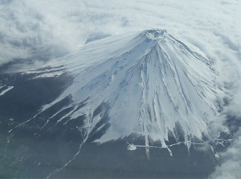
The iconic Mount Fuji is the highest mountain in Japan, and an active stratovolcano that last erupted in 1708. It can be seen from the city of Tokyo on a clear day off to the west. It stands at an elevation of 3,776 meters and is surrounded by 5 lakes.
Mount Fuji probably started erupting several hundred thousand years ago. The interior of the mountain is an andesite core that erupted first. over top of that is a basalt layer that probably erupted a few hundred thousand years ago. About 100,000 years ago, a new layer called “Old Fuji” covered that. And now the newest layer is known as, surprisingly, “New Fuji”, forming about 10,000 years go. Fuji is located at the point where the Eurasian Plate, the Okhotsk Plate and the Philippine Plate meet.
The last recorded eruption of Mount Fuji was on December 16, 1707. Eruptions lasted until January 1, 1708, with cinders and ash raining down on villages surrounding the mountain. And since then, the mountain has been quiet.
It’s believed that Mount Fuji was first climbed by a monk in 663, and the first foreigner was Sir Rutherford Alcock in September 1860. Today an estimated 200,000 people climb Mount Fuji every year. The ascent takes about 8 hours, and the descent takes just 2-3 hours to come back down.
We have written many articles about volcanoes for Universe Today. Here’s an article about other famous volcanoes, and here’s an article about Mount Pinatubo.
[/caption]
Mount Stromboli is an active volcano on a small island off the north coast of Sicily – one of three active volcanoes in Italy. The volcano itself rises 924 meters above sea level, but it actually rises 2,000 meters from the floor of the ocean. It is one of the most active volcanoes in the world, erupting almost continuously for the last 2,000 years.
The eruptions of Stromboli are seen best at night, when chunks of lava blasted out of the volcano trace bright red arcs in the sky. In fact, it’s such an iconic type of eruption that geologists have named an entire class of eruptions after Mount Stromboli. Whenever you get a volcano blasting out blobs of hot lava, gas and rocks in arcs from its volcanic vent, that’s a strombolian eruption. This kind of eruption has been seen in volcanoes worldwide.
The largest (recent) eruption on Mount Stromboli happened in 1930, and resulted in the deaths of several people and the destruction of several homes. Large eruptions like this happen every decade or so. With such regular and predictable volcanic activity, tours used to go up the side of Mount Stromboli at night; the best time to see the beautiful arcs of lava. But in 2007 two new craters opened up on the island, and made the volcano less predictable. Tourists have been banned from going up to the summit to watch the volcano.
You might be surprised to know that there are 400 to 750 people living on the island of Stromboli, in the shadow of the volcano.
We have written many articles about volcanoes for Universe Today. Here’s an article about Mount Etna, and here’s an article about Mount Vesuvius; the two other active volcanoes in Italy.
[/caption]
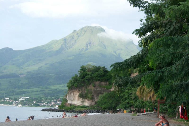
Mount Pelee, on the island of Martinique in the Caribbean is one of those volcanoes with such a famous and devastating eruption, that a whole class of eruptions has been named after it. In 1902, it was the source of the worst volcanic disaster of the 20th century when a pyroclastic flow blasted down its flanks and killed more than 30,000 people destroying the town of Saint-Pierre.
The volcano has an elevation of 1,397 meters, and is part of a chain of volcanoes that stretch from Puerto Rico to Venezuela. This is the point where the Caribbean Plate Meets the Atlantic Oceanic crust belonging to the South American Plate. With all this tectonic action, there are many active volcanoes in the region. Mount Pelee is a common stratovolcano, composted of many layers of lava flows and fragmented volcanic debris. The current cone formed in the last 3000 years after a previous cone collapsed in an eruption similar to Mount St. Helens.
Inhabitants of Martinique could see evidence that Mount Pelee was awakening in 1900 when activity on the volcano increased. There were relatively minor steam eruptions, and there were several minor blasts of cinders and ash. There were several larger eruptions, but these were just setting the stage for the big eruption on May 8, 1902. Observers saw the side of Mount Pelee detonate, with a dense black cloud of ash shooting out horizontally. This sent a pyroclastic flow down the slopes of the volcano, reaching and destroying the town of Saint-Pierre within a minute.
Vulcanologists have named an entire class of eruptions after what happened on Mount Pelee. Pelean eruptions describe when a volcano has a horizontal explosion on its flanks, sending out pyroclastic flows. They’re some of the most dangerous eruptions in the world.
We have written many articles about volcanoes for Universe Today. Here’s an article about pelean eruptions, and here’s an article about Mount Pinatubo.
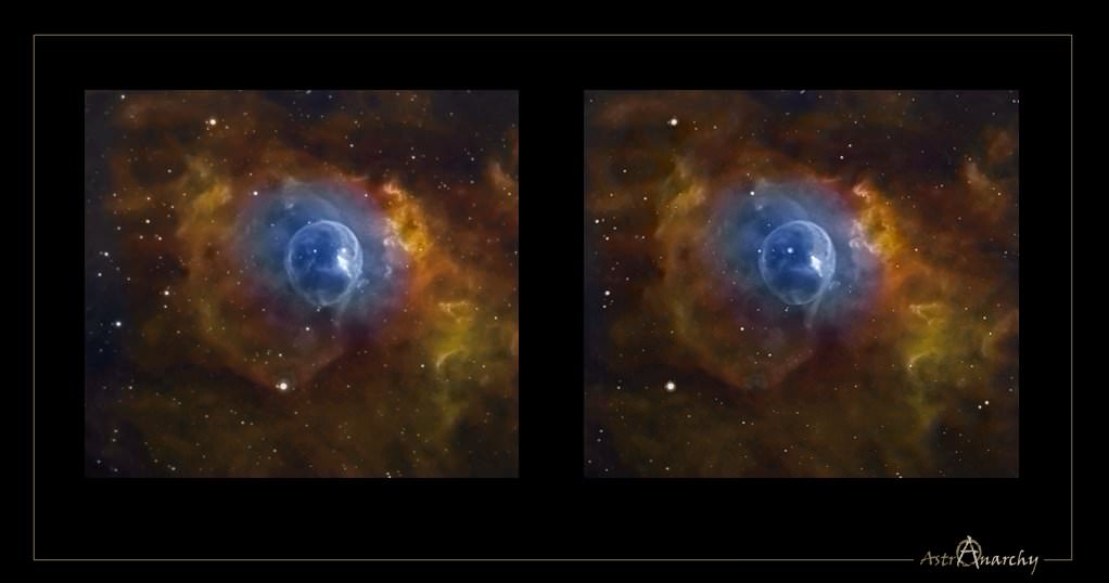
Away in the constellation of Cassiopeia some 7,100 light-years from Earth, a star 40 times more massive than our Sun is blowing a giant bubble of its own material into space. Inside its magic blue sphere, the gigantic star burns at blue flame intensity – rendering a 6 light year wide envelope of hot gas around it that’s expanding outward at a speed of 4 million miles per hour. Are you ready to open wide and step inside? Then welcome to a little dimensional magic….
As always, whenever we present a dimensional visualization it is done in two fashions. The first is called “Parallel Vision” and it is much like a magic eye puzzle. When you open the full size image and your eyes are the correct distance from the screen, the images will seem to merge and create a 3D effect. However, for some folks, this doesn’t work well – so Jukka has also created the “Cross Version”, where you simply cross your eyes and the images will merge, creating a central image which appears 3D. For some folks, this won’t work either… But I hope it does for you!
NGC 7635 Cross Vision by JP Metsavainio
As the central star in NGC 7635 sheds its material, we can see it isn’t even and its appearance varies with the thickness of the surrounding gases. What appears to be cloud-like structures are very thick and illuminated by the star’s intense ultraviolet light. Believe it or not, it is here where the stellar “winds” blow the fastest and it won’t be long until these areas quickly erode. However, there is one feature that stands out more than any other – the “bubble-within-a-bubble”. What is it? It may be two distinct winds… Two distinct streamers of material colliding together.
“The bubble in NGC 7635 is the result of a fast stellar wind expanding into the interior of the larger H II region. However, the central star BD +60 2522 is appreciably offset (by about 1′) from the center of the bubble in the direction of the wall of the dense molecular cloud that defines this blister H II region.” says B.D. Moore (et al), “This offset is the result of evolution of the wind bubble into the density and pressure gradient established by the photoevaporative flow away from the cavity wall. The physical conditions around the bubble vary according to the medium into which the bubble is expanding. Away from the cavity wall the bubble is expanding into the low density interior of the H II region. Toward the wall, in the region of our images, the wind termination shock is very near the ionization front. The resulting physical structure, in which the photoevaporative flow away from the cloud wall is confined by the ram pressure of the wind.”
But, are we not seeing the proverbial forest because we’re too busy looking at the trees? “BD +60 is the ionizing star of NGC 7635, the so-called “Bubble Nebula”. NGC 7635 lies at the edge of a low-density clumpy molecular cloud and the nebula can be interpreted as a wind-blown bubble created by the interaction of the stellar wind of BD +60 with the ambient interstellar medium. While many investigations have focused on the nebula, little attention has been paid to the star itself.” says G. Rauw (et al), “Considerable progress in our understanding of the stellar winds of early-type stars has been achieved through extensive monitoring of their spectroscopic variability and the discovery that some of the cyclical variations could be related to a rotational modulation of the stellar wind. Since rotation is believed to shape the winds of Oef stars, these objects appear a priori as good candidates to search for a rotational wind modulation.”
Throughout their long term observing campaign, the group found strong profile variability on time scales of 2–3 days, variability on time scales of a few hours that might be related to non-radial pulsations, and even tentatively propose that the beating of several non-radial pulsation modes triggers transient large-scale density perturbations in a confined stellar wind that produce the 2–3 day time scale variability. “While this scenario could easily account for the lack of a single stable period (through the effect of the propagation velocity of the perturbation and the interplay of various clocks: pulsations, rotation…), it seems more difficult to explain the changing pattern of the TVS. For instance, if a density wave moves around the star, why would it not affect the absorption and the emission components in a similar manner?” says Rauw, “One possibility could be that the density perturbation affects the absorption column only as long as it remains close to the stellar surface whilst the impact on the emission lines would be larger when the perturbation has moved outwards, but this is admittedly still rather speculative.”
Just how common is it for a huge star to form a bubble around itself? “Massive stars evolve across the HR diagram, losing mass along the way and forming a variety of ring nebulae. During the main sequence stage, the fast stellar wind sweeps up the ambient interstellar medium to form an interstellar bubble. After a massive star evolves into a red giant or a luminous blue variable, it loses mass copiously to form a circumstellar nebula. As it evolves further into a WR star, the fast WR wind sweeps up the previous mass loss and forms a circumstellar bubble. Observations of ring nebulae around massive stars not only are fascinating, but also are useful in providing templates to diagnose the progenitors of supernovae from their circumstellar nebulae.” says You-Hua Chu of the University of Illinois Astronomy Department, “The fast stellar wind of a main sequence O star sweeps up the ambient interstellar medium (ISM) to form an interstellar bubble, which consists of a dense shell of interstellar material. Intuitively, we would expect around most O stars an interstellar bubble similar to the Bubble Nebula (NGC 7635) to be visible; however, hardly any O stars in HII regions have ring nebulae, suggesting that these interstellar bubbles are rare.”
Like a child chewing gum, the bubble will continue to expand. And what comes after the bubble? Why, the “bang” of course. And when it comes to a star going bang, than can only mean a supernova. “By pursuing the calculation through the various stages of massive star evolution, using a realistic mass loss history as input, we simulate the creation and evolution of a wind-blown bubble around the star up to the time of the supernova explosion.” says A. J. van Marle (et al), “The outflowing matter encounters an inner shock, where its velocity is reduced to nearly zero. The kinetic energy of the wind becomes thermal energy. This interaction creates a “hot bubble” of nearly stationary, hot gas. The thermal pressure of the hot bubble drives a shell into the surrounding interstellar medium. Here it is assumed, that the pressure driven shell will be restrained only by the ram pressure created by its own velocity and the density of the surrounding medium. This assumption is correct if we consider the surrounding medium to be cold. However, if we take photo-ionization into account the situation becomes rather more complicated. First of all, the photoionized gas will have a much higher pressure than the cold ISM. Therefore, the HII region will expand, driving a shell into the ISM. Second, the hot-bubble created by the stellar wind will now expand into a hot HII region, which means that the thermal pressure restraining the shell, will no longer be negligible compared to the ram pressure. A wind-blown bubble expanding into a compact HII region can be observed in NGC 7635.”
So how do we know when the final moments have come? “As the star ages, it becomes a red supergiant with a dense and slow wind. The number of ionizing photons drops. Therefore, the HII region disappears. Owing to the low density, recombination will take a long time, but radiative cooling will cause a decrease in thermal pressure. The hot wind-bubble, which keeps its high pressure, expands into the surrounding gas, creating a new shell. A third shell appears close to the star, as the drop in ram pressure from the RSG wind causes the wind bubble to expand inward, sweeping up the wind material.” say van Marle, “The presence of an expanding HII region changes the density structure of the nebula during the main sequence. Our main goal at this time is to simulate the circumstellar environment of stars between 25 M and 40 M at the time of the supernova explosion.”
Magic bubbles? Just stay out of the way when they pop!
Many thanks to JP Metsavainio of Northern Galactic for his magical personal image and allowing us this incredible look at distant beauty!
[/caption]
At any time there are about 20 volcanoes actively erupting around the world, and about 50-70 volcanoes have erupted in the last year or so. There are a total of 550 volcanoes that have erupted in all of recorded history. Some of these active volcanos are extremely famous, often because of a tremendous loss of life. Here’s a list of some famous volcanoes:
Caribbean
Mount Pelee – A stratovolcano on the island of Martinique that killed more than 30,000 people during an eruption in 1902.
Cotopaxi – A very active volcano in Ecuador, popular with hikers.
Chimborazo – This dormant stratovolcano is the highest point in Ecuador, and actually the most distant point from the center of the Earth.
Cayambe – Another dormant stratovolcano in Ecuador. It’s the third tallest peak in the country.
Greece
Thera – The volcano that devastated the island of Santorini; one of the most powerful volcano eruptions in recorded history.
Indonesia
Krakatoa – This used to be an island in the Sunda Strait near the island of Java. It exploded in 1883 creating one of the largest eruptions in recorded history.
Mount Tambora – A stratovolcano on the island of Sumbawa in Indonesia. It exploded in 1815 producing the most powerful eruption in recorded history.
Mount Merapi – An active volcano in Indonesia, on the island of Java near the city of Yogyakarta. It’s so active that ash is almost constantly coming out the top of the volcano, and it has had several recent devastating eruptions.
Italy
Mount Etna – An active volcano on the Island of Sicily. It’s in an almost constant state of eruption, with huge ash clouds visible from the island.
Mount Vesuvius – A dangerous volcano near Italian city of Naples. It’s most famous for the devastating eruption in AD 79 that destroyed the towns of Pomeii and Herculaneum.
Mount Stromboli – An active volcano just off the coast of Sicily. It has been constantly erupting for the last 2,000 years or so.
Japan
Mount Fuji – The iconic Japanese stratovolcano – the highest point in Japan.
Mauna Loa – This active shield volcano is the second tallest volcano in the world, but it’s the biggest volcano in the world, with the most volume. It has erupted within the last century.
Hualalai – The third most active volcano in Hawaii.
Kilauea – An active volcano on the eastern side of the Island of Hawaii. It’s in an almost constant state of eruption, and one of the most active volcanoes in the world.
Kohala – The oldest of the 5 volcanoes on the Big Island of Hawaii.
Mauna Kea – The tallest volcano in the world, located on the Big Island of Hawaii.
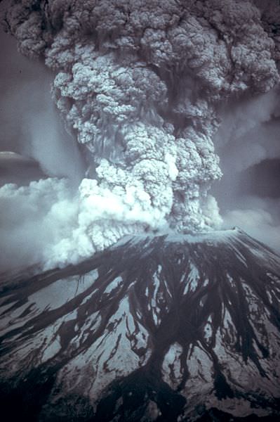
Mount St. Helens – An active volcano in Washington State. It detonated in 1980, destroying thousands of square km of forest and killed 57 people.
Mount Mazama – This is the name for the stratovolcano that exploded more than 7000 years ago, creating what is now Crater Lake in Oregon.
Mount Rainier – An active stratovolcano that dominates the skyline over Seattle. 150,000 people live on mudflows that erupted out of the volcano 5,000 years ago.
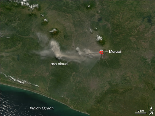
[/caption]
Mount Merapi is an active volcano in Indonesia, on the island of Java near the city of Yogyakarta. The volcano is so active that smoke can be seen coming out of the peak almost every day of the year. Mount Merapi has been erupting regularly since 1548.
Mount Merapi is located in the subduction zone, where the Indo-Australian Plate is going under the Eurasian Plate. Geologists estimate that the volcano started forming 400,000. It was largely built up by basaltic lava flows, but the lava flows have become more viscous in the last 10,000 years or so. With the thicker lava, Merapi has had more explosive eruptions and the formation of lava domes. Merapi has minor eruptions every 2 years or so, and major eruptions every few decades.
Even though it’s an extremely active volcano, thousands of people live on its flanks. Hot gas killed 43 people in 1994, and 13 villages and 1400 people were killed by pyroclastic flows during an eruption in 1930. A series of earthquakes struck Mount Merapi in April/May 2006, the most powerful one on May 27th killed 5,000 people. An eruption on June 14, 2006 spewed out a cloud of volcanic ash that covered a village several kilometers away.
We have written many articles about volcanoes for Universe Today. Here’s an article about Mount Pinatubo, and here’s an article about Mount Tambora.