Nancy has been with Universe Today since 2004, and has published over 6,000 articles on space exploration, astronomy, science and technology. She is the author of two books: "Eight Years to the Moon: the History of the Apollo Missions," (2019) which shares the stories of 60 engineers and scientists who worked behind the scenes to make landing on the Moon possible; and "Incredible Stories from Space: A Behind-the-Scenes Look at the Missions Changing Our View of the Cosmos" (2016) tells the stories of those who work on NASA's robotic missions to explore the Solar System and beyond.
Follow Nancy on Twitter at https://twitter.com/Nancy_A and and Instagram at and https://www.instagram.com/nancyatkinson_ut/
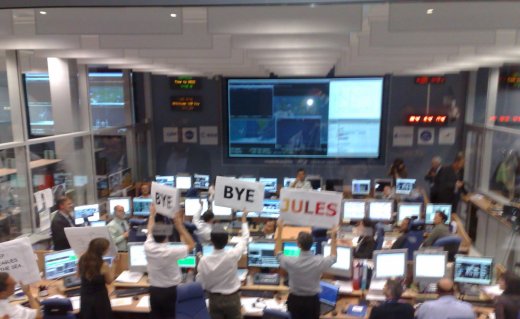
ESA's ATV Control Room following de-orbit burn. Credit: ESA
[/caption]
Europe’s Jules Verne Automated Transfer Vehicle (ATV) successfully completed its six-month mission today with a controlled destructive re-entry over the South Pacific. Following a final de-orbit burn at 14:58 CEST which slowed its velocity by 70 m/s, the ATV entered the upper atmosphere at an altitude of 120 km at 15:31 CEST. It broke up at an altitude of 75 km with the remaining fragments falling into the Pacific some 12 minutes later. The break-up was monitored by two aircraft, a Gulfstream V, and a NASA DC-8. “The operations went perfectly; there was no hiccup at all.” said ESA’s mission director Alberto Novelli. “There is a very big feeling of accomplishment because the mission went perfectly from end to end. At the same time we are a little bit sad. The six months (of operation) were very intense and demanding, so there is a mixed feeling. But we are looking forward to start preparing for the following mission.” Update: the first images from the re-entry have just been posted: ATV re-entry. Credit: ESA
Composite of the ISS and ATV as seen from Earth. Credit: Ralf Vandebergh
This first ATV launched on March 9, 2008 on an Ariane 5 rocket from Europe’s Spaceport in French Guiana. Named the Jules Verne, it delivered 6 tonnes of cargo to the International Space Station, and remained docked to the ISS for five months. During docked operations, it also performed a maneuver to help the ISS avoid a piece of space debris. The crew was able to offload 12 tonnes of waste into the Jules Verne, most of which should have been destroyed in the re-entry. Another image of the ATV re-entry. Credit: ESA
A group of researchers used imaging instruments and spectrographs on board the two aircraft to document the re-entry. Both aircraft are suited to flying at the high altitude needed to perform the observations (12 to 14 km). They measured the brightness of the fragments, obtained positional information and saw how the brightness of the vehicle changes over time, giving an indication of how the spacecraft is tumbling. The spectrograph measures emissions from the atmosphere as the re-entry occurs, which provides information of the flow of the atmosphere around the vehicle. As they analyze their data, they will also be able to see emissions from the vehicle and contents as they break apart, give a detailed understanding of what’s happening to the ATV as it re-entered the atmosphere. Researchers monitored the ATV's re-entry from two aircraft. Credit: ESA
“Credit has to go to everyone involved in such a flawless mission.” said John Ellwood, ESA’s ATV Project Manager. “Not only to the ESA and industrial teams that brought the project to fruition, but also to the teams at the ATV Control Centre and around the world who have done a superb job while the spacecraft has been in orbit. This is truly a wonderful spacecraft, and vital to the continued service of the ISS following Shuttle retirement in 2010. I look forward to the launch of the next ATV, which is currently under production at EADS Astrium in Bremen, Germany.”
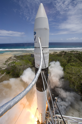
The face of future NASA launches? The SpaceX Falcon 1 blasts off (SpaceX)
The commercial spaceflight company Space X successfully launched its Falcon 1 unmanned booster, becoming the first private company to send a rocket into orbit. The two-stage rocket lifted off at 7:16 p.m. EDT (23:16 GMT) from the the launch site on the Kwajalein Atoll in the about 2,500 miles (4,023 km) southwest of Hawaii. This successful launch comes almost two months after an engine timing error during stage separation caused the failure of Space X’s third Falcon 1 test. If you missed watching the live webcast, below is the video. Watching the live webcast was wonderful; the people who actually built this rocket could be heard cheering in the background as each milestone in the climb to orbit was reached. Congratulations to everyone at Space X!
After the Falcon 1 reached orbit, an elated Elon Musk, Space X CEO told his cheering employees, “As the saying goes, the fourth time’s the charm.” He said this is just the first step for Space X, and added “This is one of the best days of my life.”
SpaceX’s first three attempts to launch the Falcon 1 all failed, with different problems occurring on each try. But today, after a uneventful countdown, the two-stage rocket operated flawlessly, bringing a dummy payload to Earth orbit. “This was the smoothest launch countdown of all,” Musk said. “It just shows the team is getting more and more practice at this.”
The Falcon 1 is a two stage, liquid oxygen and rocket grade kerosene (RP-1) powered launch vehicle. It is designed from the ground up by Space X, with no government assistance. Space X has about 500 employees.
As winner of NASA’s Commercial Orbital Transportation Services (COTS) competition, SpaceX is designing and building the Falcon 9 human-rated launch vehicle and Dragon spaceship to transport cargo and then astronauts to the International Space Station.
Space X’s mission is to provide launch vehicles at low cost and high reliability. This success could be the beginning of a new era in spaceflight.
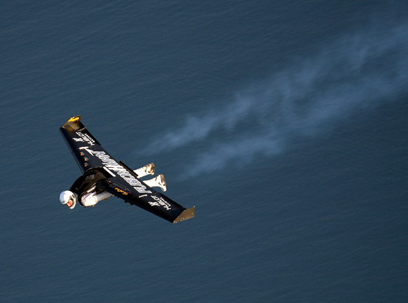
Fusionman soars across the English Channel. Credit: Times Online
[/caption]
In May, Swiss adventurer Yves Rossy, who calls himself “Fusionman,” flew with a jetpack strapped to his back for just 5 minutes. Today he soared from France to England across the English Channel, becoming the first person to cross the 35 km (22 miles) body of water in such a way. Rossy, a pilot who normally flies an Airbus airliner, was dropped from an airplane over France and used his specially made jetpack, flying at speeds of up to 193 kph (120 mph) to make the crossing in 13 minutes. “Everything was perfect,” he said afterwards. “I showed that it is possible to fly a little bit like a bird.” See more images and video below.
The 22-mile flight from Calais to Dover took 10 minutes (National Geographic/BSkyB)
The 49-year-old Rossy, told the BBC the most tense moment was when he jumped from the aircraft “because I did have many problems during exits before.” He ignited the four kerosene-burning jets on the jetpack inside a plane before jumping out more than 2,440 meters (8,000 feet) above ground. He made a perfect exit and quickly set the correct course by aiming for the cliffs of Dover. After a period of free fall he opened the wing and soared across the water. With no steering controls, the only way to change direction was like a bird, moving his head and back.
About 15 minutes later Rossy parachuted towards his landing site near Dover after making the crossing (Adrian Dennis/AFP/Getty)
Rossy’s jet-powered wing, which spans eight feet, is made of lightweight carbon composite and weighs about 55 kg (120 lb) including fuel. Rossy has to wear a flameproof suit to help him withstand the jet exhaust around his legs.
When the white cliffs of Dover came into view, he opened a blue and yellow parachute and drifted down in light winds to land in a British field where he was mobbed by well-wishers. The Swiss pilot Yves Rossy is sprayed with champagne near Dover after flying with jet-propelled wings across the Channel from France (Adrian Dennis/AFP/Getty)
Rossy celebrated his flight with a champagne shower. He had postponed the flight twice earlier this week due to poor weather.
His future plans include flying over the Grand Canyon, taking off from a standing position on the ground and performing acrobatics.
[/caption]
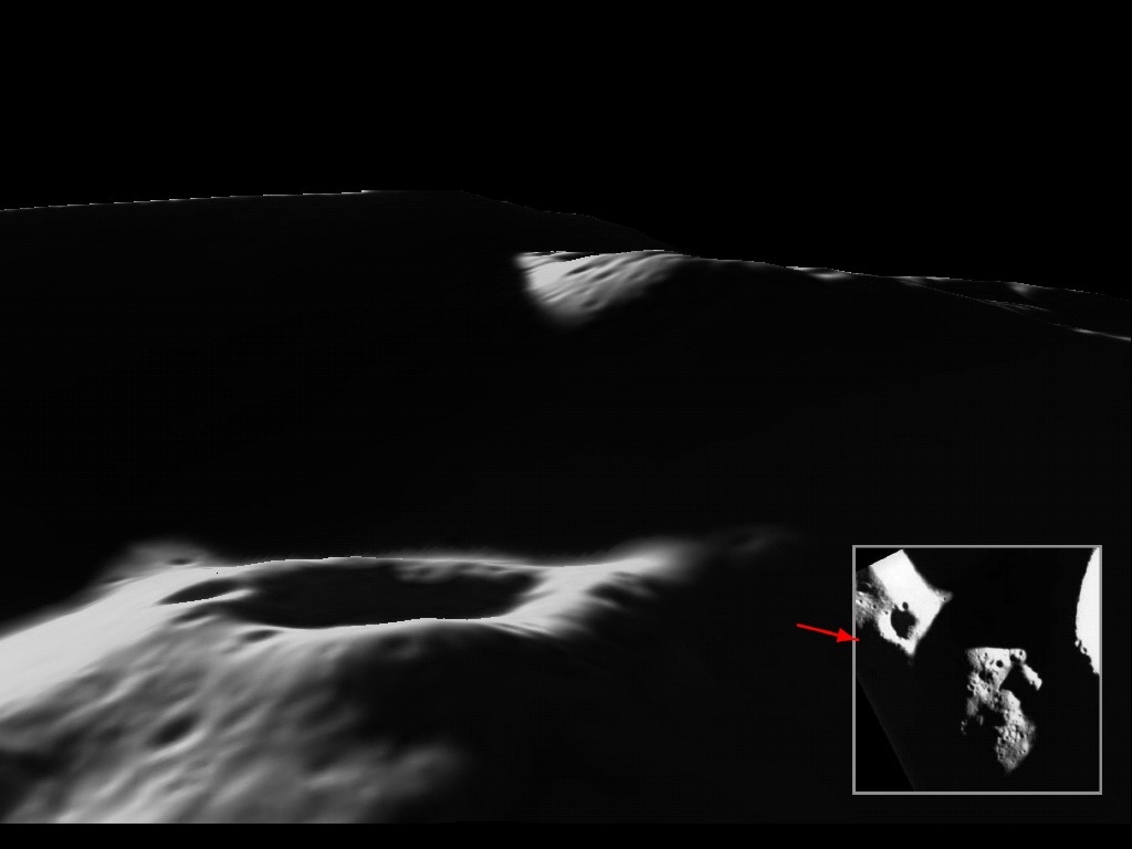
Scientifically speaking, where is the best place on the Moon to set up a colony for research? Hands down, it has to be the Moon’s south pole. Mountainous areas near the rim of Shackelton Crater provide areas of almost continual sunlight, meaning solar power would be constantly available. In addition, the shadowed craters are in constant darkness and may hold water ice, a potential water supply that would be a vital resource for any lunar base. Plus it would be a great place to set up a lunar telescope. Recently, three-dimensional views of this region were released by the European Space Agency, taken by the SMART-1 spacecraft, providing unprecedented details of what has been called the “Peak of Eternal Light.” Moon base designers, take a look…
This image from the Clementine mission shows seven possible colony sites on the Moon’s south pole. Circled in red the highest mountain, the so-called “Peak of Eternal Light.”
View of “Peak of Eternal Light”. The Shackleton Crater is just off the image on the right hand side. Potential landing site 4 from the Clementine mosaic is on the left hand ridge of the peak. The small crater in the centre of the image is about 1 kilometre across. Credit: ESA/SMART-1/Space-X (Space Exploration Institute)
The images were taken by the AMIE camera on board the SMART-1, which has since plunged into the moon’s surface in a planned crash in 2006. The camera team has been working with the data to create digital elevation model of the peaks.
“AMIE is not a stereo camera, so producing a 3-D model of the surface has been a challenge,” said researcher Dr. Detlef Koschny. “We’ve used a technique where we use the brightness of reflected light to determine the slope and, by comparing several images, put together a model that produces a shadow pattern that matches those observed by SMART-1.” View of “Peak of Eternal Light” from the rim of the Shackleton Crater. The peak is along the ridge in the centre of the image. The possible landing sites 1 & 2 from the Clementine mosaic are in the bottom right hand corner of the image. Credit: ESA/SMART-1/Space-X (Space Exploration Institute)
AMIE took a total of 113 images of the peak, located close to the rim of the Shackleton Crater. The team, led by Dr Bjorn Grieger of ESA’s European Space Astronomy Centre in Madrid, took five of the best images showing the peak illuminated from different angles. They mapped all the pixels onto a grid, defining the bright and dark areas. The data from the five images were then compared to produce estimates of the slope angles and the rendered elevation model was iteratively adjusted to produce a shadow match. The original AMIE images were then projected onto the retrieved model. To clearly visualise the topography, the elevation has been exaggerated five times. Here’s the elevation map: Digital elevation map. Credit: ESA/SMART-1/Space-X (Space Exploration Institute
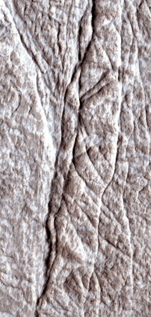
Deformation bands on Mars. credit: NASA/JPL-Caltech/Univ. of Arizona
[/caption]
NASA’s Mars Reconnaissance Orbiter has revealed hundreds of small fractures exposed on the Martian surface that billions of years ago directed flows of water through underground Martian sandstone. Researchers used images from the spacecraft’s HiRISE (High Resolution Imaging Science Experiment) camera. Images of layered rock deposits at equatorial Martian sites show the clusters of fractures to be a type called deformation bands, caused by stresses below the surface in granular or porous bedrock. “Groundwater often flows along fractures such as these, and knowing that these are deformation bands helps us understand how the underground plumbing may have worked within these layered deposits,” said Chris Okubo of the U.S. Geological Survey in Flagstaff, Ariz.
Visible effects of water on the color and texture of rock along the fractures provide evidence that groundwater flowed extensively along the fractures. “These structures are important sites for future exploration and investigations into the geological history of water and water-related processes on Mars,” Okubo and co-authors state in a report published online this month in the Geological Society of America Bulletin. Deformation bands in the Four Corners region of the US. Credit: Jon E. Olson
Deformation band clusters in Utah sandstones, as on Mars, are a few meters or yards wide and up to a few kilometers or miles long. They form from either compression or stretching of underground layers, and can be precursors to faults. The ones visible at the surface have become exposed as overlying layers erode away. Deformation bands and faults can strongly influence the movement of groundwater on Earth and appear to have been similarly important on Mars, according to this study.
“This study provides a picture of not just surface water erosion, but true groundwater effects widely distributed over the planet,” said Suzanne Smrekar, deputy project scientist for the Mars Reconnaissance Orbiter at NASA’s Jet Propulsion Laboratory in Pasadena, Calif. “Groundwater movement has important implications for how the temperature and chemistry of the crust have changed over time, which in turn affects the potential for habitats for past life.”
Deformation bands form when sections of rock slide past each other and are similar to faults, such as the much larger San Andreas Fault in southern California. The discovery of deformation bands in HiRISE images advances understanding of how underground fractures would have affected the distribution and availability of ancient groundwater on Mars.
The HiRISE camera took the top image of layered rocks inside a crater in the Arabia Terra region of Mars on Feb. 13, 2007. The site is at 6.6 degrees north latitude, 14.1 degrees east longitude. Illumination is from the left. North is toward the top. The ground covered in this image spans about 150 meters (about 500 feet) east to west.
In a bold move, astronomers have begun a new search to understand and explain the origin, nature and prevalence of intelligent life in the universe. Called WETI, which stands for Wait for Extra Terrestrial Intelligence, the institute employs an entirely novel approach to achieve its goals. Instead of actively searching for extraterrestrial intelligence, the idea is to simply wait: Wait until the ETs find us. “Waiting is a notoriously underappreciated method in our efforts to search for extraterrestrial intelligence,” says the WETI website. “It is cheaper and less stressful than any other type of research. It is also environmentally friendly and does not cause global warming, terrorism or nuclear conflicts.” WETI’s overall objective? To set a new gold standard for scientifically meaningful waiting, and to provide humankind a new purpose as they wait.
The work of WETI was recently highlighted at the Dot Astronomy Conference on Networked Astronomy and the New Media. WETI officials overcame several problems, and were able to present a poster at the conference. Then they went out for drinks, presumably to make the waiting more enjoyable.
The poster introduces the very foundations of WETI, which includes the breakthrough “Brake Equation.” See the poster for more details.
In the near future, whenever they get around to it, WETI will provide a downloadable computer program that will make use of the idle time of your computer to very efficiently wait in the background. “Modern computers can wait several million times each second,” says WETI. “By exploiting this currently unused waiting potential we will collectively create the biggest waiting power ever applied to any problem on earth.”
I contacted the WETI Institute for more information and was pleasantly surprised that I did not have to wait very long for a reply. An Aleks Scholz, the Deputy Chief Executive Officer of WETI, responded to my inquiries. When asked about the response WETI has received thus far, Scholz said,” Generally positive, with a slight inclination of being confused at first, plus occasional cases of consternation. So far, however, there were no medically relevant problems related to the responses to WETI.”
The history of the WETI Institute appears to be long and muddled. “We are still working on tracking down the roots of our organization,” said Scholz. “Most of us, however, believe that it was Knarps Hoselton who originally provided the stimulus for the WETI movement with his inspirational piece of research ‘On Some Philosophical Implications of Throwing Small Stones into a Big Body of Water’ in the early 80s. Today, Hoselton is Senior Astronomer and holds the Bruno Moravetz Chair Emeritus at the WETI Institute.” In more recent years, Scholz himself, an astronomer at the University of St. Andrews, picked up on Hoselton’s revolutionary ideas and suggested combining them with networking technology. This was the beginning of the WETI Institute.
When asked how long we may have to wait for results from this new initiative, Scholz said, “We prefer to see each day of WETI as a ‘result’, providing us with one bit of information about the nature of extraterrestrial intelligence– they are somewhere else. The non-presence of aliens on planet Earth is as useful for science as their presence would be. We will not accept any notion that waiting is only useful if, finally, something happens. Instead, we consider waiting a fulfilling scientific method in its own right.”
So, is this a joke? Maybe. Or maybe not. “It seems appropriate to ponder the actual usefulness of WETI” says the WETI website. “Where do we come from? Where do we go? Can we have coffee in between?” Well, thanks to the WETI Institute, the process of answering these questions turns into a social experience – a global, conscious waiting process. With WETI, everyone at least knows that they are waiting. This provides new purpose to humankinds’ seemingly eternal waiting. We can all now wait with fierce determination.
If you find yourself not very adept at waiting, Scholz offered a few tips. “With our expertise, we can suggest a number of things: The long-established technique of fiddling your thumbs, for example, is a good start. You might also want to take a sheet of graph paper and fill in all the squares with a soft pencil. When you are finished, you could arrange for a nice cup of tea, just for a change. Finally, procrastination is always a valid option. Surely there is something you should be doing right now. Concentrate your energies on not doing it.”
In the words of Galaxy Zoo’s Chris Lintott, “This is both brilliant, and completely mad.”
Update: You can now join WETI’s “think tank,” the Effortless Action Committee. When you do you can receive an attractive certificate suitable for framing immediately — no waiting!
China successfully launched its third manned spacecraft today with three astronauts on board. During the mission, they will attempt the country’s first-ever space walk. The Long March II-F rocket carrying the Shenzhou-7 spacecraft blasted off from the Jiuquan Satellite Launch Center in the northwestern Gansu Province at 9:10 p.m. local time. Onboard pilots Zhai Zhigang, Liu Boming and Jing Haipeng are will orbit Earth for three days. The astronauts, called taikonauts, told the ground control center that they felt “physically sound” in the first few minutes of the flight.
Two of the taikonauts will conduct a spacewalk, wearing Chinese-made spacesuits called Feitian which literally means flying in the sky, and is the name of a legendary Buddhist goddess. They will retrieve test samples loaded on the outside of the spacecraft, said Zhou Jianping, chief designer of the country’s manned space project.
“We wish we could fly freely in space just like Feitian on the ancient Buddhist murals, so we gave this name to the homemade spacesuit,” said Zhou. Chinese taikonauts inside Shenzou 7. Credit: Xinhuanet
The third taikonaut will remain inside the pressurized spacecraft, and will wear a Russian Orlan suit.
Other tasks of the Shenzhou-7 crew include the release of a small monitoring satellite and a trial of the data relay of the satellite Tianlian-I.
If successful, the mission would be of great significance to the country’s future plans to build a space lab and a space station, said Zhang Jianqi, deputy chief commander of the manned space project. “China pursues the principle of making peaceful use of space in its exploration and development,” Zhang said, adding the country was willing to carry out various forms of international cooperation in space exploration.
The taikonauts, all 42 years old, are scheduled to land in the central region of north China’s Inner Mongolia Autonomous Region in a re-entry module after their mission is completed
Composite image of the nearby Circinus Galaxy. Credit: X-ray (NASA/CXC/Columbia/F.Bauer et al); Visible light (NASA/STScI/UMD/A.Wilson et al.)
[/caption]
Back in 2001, astronomer Franz Bauer noticed a bright, variable source in the Circinus spiral galaxy, using NASA’s Chandra X-ray Observatory. Although the source displayed some exceptional properties Bauer and his Penn State colleagues could not identify its nature confidently at the time. But now, seven years later Bauer and his team have confirmed this object was a supernova. By combining online data in the public archives from 18 different ground- and space-based telescopes, one of the nearest supernovae in the last 25 years, SN1996cr, has finally been identified. “It’s a bit of a coup to find SN 1996cr like this, and we could never have nailed it without the serendipitous data taken by all of these telescopes. We’ve truly entered a new era of ‘internet astronomy’,” said Bauer.
Because this object was found in an interesting nearby galaxy, the public archives of these telescopes contained abundant observations. Clues from a spectrum obtained by ESO’s Very Large Telescope led Bauer and his team to start the real detective work of searching through data from various telescopes.
The data show that SN 1996cr is among the brightest supernovae ever seen in radio and X-rays. Visible-light images from the archives of the Anglo-Australian Telescope in Australia show that SN 1996cr exploded sometime between 28 February 1995 and 15 March 1996, but it is the only one of the five nearest supernovae of the last 25 years that was not seen shortly after the explosion.
It also bears many striking similarities to the famous supernova SN 1987A, which occurred in a neighbouring galaxy only 160,000 light-years from Earth. Until now, it was the only known supernova with and X-ray output that increased over time. SN1996cr has the same attributes, but is much brighter.
“This supernova appears to be a wild cousin of SN 1987A,” says Bauer. “The two look alike in many ways, except this newer supernova is intrinsically a thousand times brighter in radio and X-rays.” Two optical imagas show the Circinus galaxy before and after the supernova. Credit: Anglo-Australian Observatory.
The combined data, in conjunction with theoretical work, have led the team to develop a model for the explosion. Before the parent star exploded, it cleared out a large cavity in the surrounding gas, either via a strong wind or from an outburst from the star late in its life. So the blast wave from the explosion itself could expand relatively unimpeded into this cavity. Once the blast wave hit the dense material surrounding SN1996cr, the impact caused the system to glow brightly in X-ray and radio emission. The X-ray and radio emission from SN 1987A is probably fainter because the surrounding material is less compact.
Astronomers think that both SN 1987A and SN 1996cr show evidence for these pre-explosion clear-outs by a star doomed to explode. Having two nearby examples suggests that this type of activity could be relatively common during the death of massive stars.
“Not only does our work suggest that SN 1987A isn’t as unusual as previously thought, but it also teaches us more about the tremendous upheavals that massive stars can undergo over their lifetimes,” said co-author Vikram Dwarkadas of the University of Chicago.
So all you internet astronomers, get out there and start clicking! Who knows what you’ll find.
Christa McAuliffe. Credit: Challenger's Lost Lessons
[/caption]
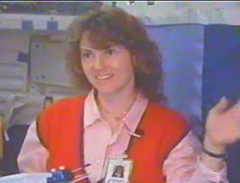
Christa McAuliffe’s life tragically ended on January 28th, 1986 when Space Shuttle Challenger exploded 73 seconds after launch, killing all seven crewmembers. She was about to make history, becoming the first teacher in space, giving unique lessons from orbit to students back on Earth. McAuliffe never had the chance to fulfill her dream of teaching from space and in the aftermath of the accident, her lesson plans were filed away by NASA with sadness and grief. The lessons were incomplete, unfinished, and most regrettably, they were never were taught. But now, 22 years later, the lessons are alive again, brought back to life by NASA engineer Jerry Woodfill who says he came across McAuliffe’s lessons by accident.
Woodfill has worked for NASA for 43 years as an electrical engineer. Most notably, he helped design the alarm system for the Apollo program. So, on Apollo 13 when Jim Lovell said, “Houston, we’ve had a problem,” Woodfill was monitoring the spacecraft.
But in 1989 Woodfill joined the New Initiatives Office, where NASA employees were asked to come up with new concepts on how to make NASA information public and easily accessible. This was about the time that PC’s and Macs were becoming popular. Woodfill had the idea of taking NASA resources that were public domain, scanning them and putting them on diskettes. He was especially interested in the educational materials NASA had. “In fact, if I hadn’t been an engineer I probably would have enjoyed being a teacher,” he said. “I like to communicate to children and adults as well, especially about science and the space program.”
Woodfill worked on compiling the NASA educational materials, and created the Space Educator’s Handbook. It was on diskettes and free for teachers. Woodfill put the word out and distributed hundreds of them. This wasn’t his day job, however. At that time he was designing concepts for going to Mars or returning to the moon. But he was able to devote some of his working hours to the New Initiatives program and the Space Educator’s Handbook, although he worked on it on his own time as well. He tried to be innovative. “I tried to create a space education encyclopedia with an attitude,” he said. “There are space comic books and coloring books, all kinds of things you wouldn’t find on an erudite space or astronomy site.”
When the internet came into vogue, Woodfill created a website and put the Space Educator’s Handbook online. He tried to keep things up to date, adding new astronaut biographies and educational materials from the various NASA missions. “All this stuff is owned by the American people who pay their taxes to support NASA,” said Woodfill.
But there were a lot of materials for one man to manage it all. “I had file cabinets full of old materials; astronaut biographies, old Toys in Space information and other things on aviation, etc.,” he said. “So last September (2007) I was thinking after working here 43 years, I should try to straighten things up a bit.”
As Woodfill was going through folder after folder of papers he came across an article about 30 pages long that included a study by an education specialist named Bob Mayfield about the Challenger mission. It proposed how Christa McAuliffe’s eight lessons would be performed on orbit.
Woodfill was intrigued. These papers probably hadn’t seen the light of day for over 20 years.
Christa McAuliffe. Credit: Challenger's Lost Lessons
“This article by Bob Mayfield was descriptions only, no sketches or anything,” said Woodfill. “But it was an excellent narrative. He did a wonderful job of writing this, but I’ve never been able to locate him. He went into great detail to consider how these things would work in Zero G, and how the experiments might affect the environment in the crew cabin – if it would be safe. I was so impressed with it. I thought, I’ve always wanted to do something about the fact that Christa and the crew never got to perform those lessons. Challenger was lost and the lessons were lost, too in that tragedy. I thought it would be wonderful if I could resurrect them in some fashion.”
So Woodfill set to work. As good as Mayfield’s narrative was, it was incomplete without McAuliffe’s input of actually doing the lessons in space. Woodfill was trying to piece everything together into cohesive lesson plans that teachers today could use, but it was difficult. At the end of Mayfield’s article was a list of videos that had been shot of McAuliffe, her backup Barbara Morgan, and Mayfield practicing and choreographing how the lessons would be done.
Woodfill thought the videos might be helpful. He started hunting for them, but had a little trouble. These videos would have been recorded in 1985, and 22 years later Woodfill wasn’t even sure they would still be in NASA’s archives. But after a few days of searching, with the help from various people in several different NASA offices, the videos were found.
They showed McAuliffe, Morgan and Mayfield, as well as some of the crew including pilot Mike Smith, and mission specialist Judy Resnick practicing the experiments. They were just short snippets, shot 20-30 seconds at a time in a shuttle simulator or in a KC-135 spacecraft (the Vomit Comet) that provided short periods of zero G to test out the procedures. Woodfill converted the videos to DVD and went through 2-3 hours of videos frame by frame to sort everything out.
Using the videos, Bob Mayfield’s paper and his own background in education in creating the Space Educator’s Handbook, Woodfill began re-creating the lessons for classroom use. Woodfill worked on the project for three months, 2-4 hours a day, some of it after hours on his own time. “I had a desire to see Christa’s work brought back to life,” he said. “There was pride, but there’s sadness and a real loss comes through because you see the crew and you remember that they didn’t survive. That motivated and drove me. It was kind of heart wrenching to work on it.”
Christa McAuliffe. Credit: Challenger's Lost Lessons
Woodfill said Mayfield’s paper covered about 15-20 per cent of all the information needed. The other 80 per cent Woodfill had to re-create. “Bob had a goal for each lesson, but I had to find the theory behind each lesson and create the materials lists, step by step processes, what the results might be and follow-up questions.
For example in the hydroponics lesson, Mayfield described it, but Woodfill had to go to the video and enlarge the frames and examine it very closely to correlate everything. Woodfill added sketches, and since there weren’t any high resolution photos of McAuliffe practicing her lessons, Woodfill captured a few good screen shots from the videos.
Christa McAuliffe. Credit: Challenger's Lost Lessons
Finally, when Woodfill finished putting everything together, he decided the best place for these lessons would be with the Challenger Learning Center, the educational centers created in memory of the Challenger crew. He sent out the completed lessons to a few of the 50 Challenger Centers, including to Rita Karl, the Director of Educational Programs at the Challenger Learning Center headquarters in Virginia.
“As you can imagine, I’ve been looking for these lessons my entire career,” said Karl, who was familiar with Woodfill from his Space Educator’s Handbook. “For Jerry to actually work with the material that was available and put these lessons together in a way that teachers could use it was really wonderful. As soon as we saw them, we immediately asked if we could host the lessons on our website.”
The lessons are now complete and available on the Challenger Center website for teachers and students around the world to use and experience what McAuliffe undoubtedly wanted to share from space.
“These lessons are really perfect for teachers who are trying to recognize the Teacher in Space mission, both Christa’s and Barbara’s and also for getting kids interested in science, technology, engineering and mathematics,” said Karl. “That’s what the Challenger families intended when they started the Challenger Center. Personally, this is a great moment, as if everything has come full circle to get these lessons available online.”
The Challenger Center recently put out a press release to let teachers know the “Challenger Lost Lessons,” as they are called, are now available. “It’s exciting to see teachers starting to use the lessons, and hopefully by the end of the year we’ll have some really good feedback. My feeling is that Christa’s lessons will be really popular,” said Karl.
Included with the lessons are clips taken from the videos of McAuliffe practicing her lessons from space. Christa McAuliffe practices teaching from space. Credit: Challenger's Lost Lessons
“If you watch the videos, Christa’s personality and her excitement really come through,” said Woodfill. “I got to know her from working with this. You really see what a bright person she was and how innovative she was. You can see all the things she contributed to the performance of the lessons.”
Woodfill says he has received calls and emails from many people, including Barbara Morgan, thanking him for his efforts in bringing back the Lost Lessons. “It’s remarkable that I came across them,” said Woodfill. “I think after the accident, nothing was done with them because Christa never got to teach the lessons from space. But it’s appropriate to do it now, because of the technology available. There’s no way you could have given this kind of treatment of these materials even 15 years ago. But now you can watch the videos and watch Christa perform her lessons. So it does resurrect them, it really does. It’s Christa’s work and it gives honor to her.”
Thanks to Woodfill, McAuliffe’s often-used quote of “I touch the future, I teach” was never more true.
Below is the Challenger Center’s video about the Lost Lessons:
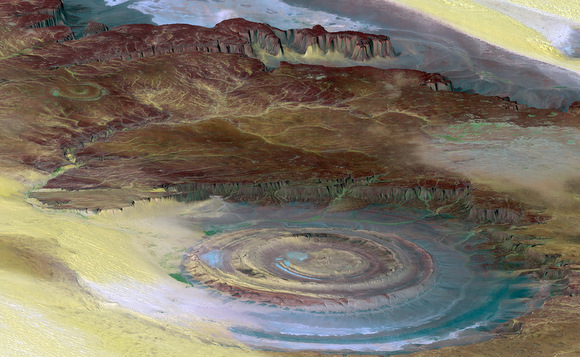
It’s time once again for this week’s Where In The Universe challenge. Take a look at the image above and try to determine where in the universe this image was taken. Give yourself extra points if you can name the spacecraft responsible for taking this image. As always, no peeking below before you make your guess. And comments are welcome if you want to share how well you did!
Make your guess, and then proceed.
This prominent circular feature, known as the Richat Structure, is found on our home planet Earth, in the Sahara Desert. Lots of astronauts have noted it and taken pictures of it because it forms a conspicuous 50-kilometer-wide (30-mile-wide) bullet’s-eye on the otherwise rather featureless expanse of the desert. Initially it was thought to be an impact crater, but it is now known to be an eroded circular anticline (structural dome) of layered sedimentary rocks.
This image was generated from a Landsat satellite image draped over an elevation model produced by the Shuttle Radar Topography Mission (SRTM), so if you said either a satellite or an astronaut took this image, you can consider yourself correct. The view uses a 6-times vertical exaggeration to greatly enhance topographic expression. To give a scale for this image, the height of the mesa ridge in the back center of the view is about 285 meters (about 935 feet) tall. This is a color enhanced image, using both visible and infrared bands, which helps to differentiate bedrock (browns), sand (yellow, some white), minor vegetation in drainage channels (green), and salty sediments (bluish whites). Some shading of the elevation model was included to further highlight the topographic features.
This is quite a striking image from the old home planet.


")
")
")

")
")