Bit by bit, scientists are piecing together Mars' climate history. Thanks to orbiters armed with powerful cameras and rovers carrying suites of scientific instruments, the red planet's history is becoming clearer year-by-year. In the past decade or so, evidence of Mars' ancient habitability is becoming more and more convincing.
In order to be habitable, Mars had to be both warmer and wetter than it is now. There are two broad types of evidence that show that's exactly what it was: One is the existence of minerals that only form in the presence of water, and the other is in landforms created by water. New evidence in NPJ Space Exploration highlights the presence of scarp-fronted deposits in Valles Marineris, features very similar to river deltas here on Earth.
The research is titled "Scarp-fronted deposits record the highest water level in Mars’ Valles Marineris," and the lead author is Ignatius Argadestya, a PhD student at the Institute of Geological Sciences and the Physics Institute of the University of Bern.
"The structures that we were able to identify in the images are clearly the mouth of a river into an ocean." - Fritz Schlunegger, University of Bern.
Valles Marineris is an extremely large tectonic crack in the Martian crust, and the largest canyon system in the Solar System. Along with Olympus Mons, it's one of Mars' defining features. This research is focused on the southeast part of Coprates Chasma, a massive sub-canyon that's a central part of Valles Marineris.
"Information on water-lain deposits on Mars provides a key contribution to the understanding of the planet’s geologic history and its past environmental conditions, particularly considering the potential for past habitability," the authors write. "Consequently, major scientific efforts have been undertaken to reconstruct the geological history of Mars by documenting the occurrence of water," they write, emphasizing what many Universe Today readers are already aware of.
The researchers used images from multiple orbital cameras: CTX and HiRISE on NASA's Mars Reconnaissance Orbiter, and CaSSIS on the ESA/Roscosmos Trace Gas Orbiter. They also worked with Digital Elevation Models (DEM) based on CaSSIS, Mars Express' High-Resolution Stereo Camera, and the Mars Orbital Laser Altimeter (MOLA) on the now defunct Mars Global Surveyor.
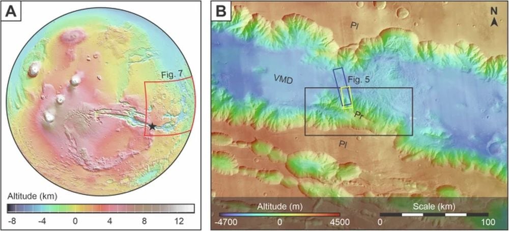 These figures show the location of the research area in Southeast Coprates Chasma. The red quadrangle in (A) shows the extent of the identified SFDs. The dark blue and yellow rectangles in (B) depict the areas for which HiRISE and CaSSIS images are available, respectively. Basemap image (B): Global CTX V1 overlain with MOLA – HRSC Global DEM V2. Pl= Plateau, Pr= Promontory, and VMD= Valles Marineris Depression. Image Credit: Argadestya et al. 2026
They used all this data to examine the "geomorphology of the promontory and the sedimentology of scarp-fronted deposits (SFDs) in Southeast Coprates Chasma," the authors write.
"In the promontory, we find a network of branched channels bordered by screes and bedrock along the drainage divides, indicating a fluvial origin," the researchers explain. "The SFDs, occurring at the downstream end of the promontory, display convex break-in-slopes, separating a flat surface with a radial drainage network from a steep front downstream." The authors say that they interpret these features to be fan-deltas with their sources in the promontory, and that they're records of an ancient high water mark.
Previous research suggested that this was the case, but it lacked the high-resolution DEMs that these authors have at their disposal. According to these results, the SFDs are where a river drained into an ocean and are evidence of an ancient coastline.
"The unique high-resolution satellite images of Mars have enabled us to study the Martian landscape in great detail by surveying and mapping," said lead author Argadestya in a press release.
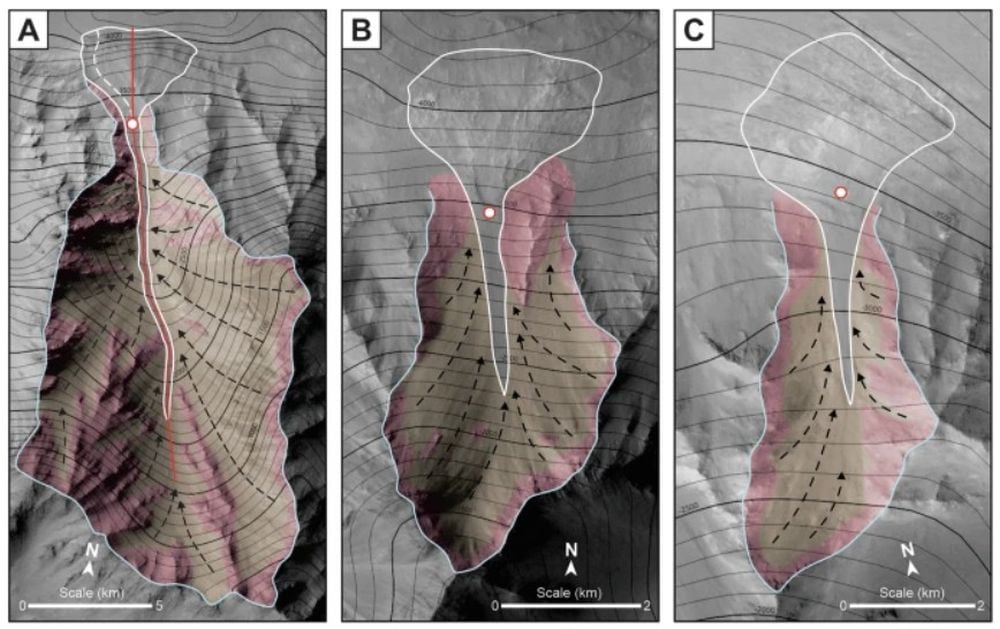
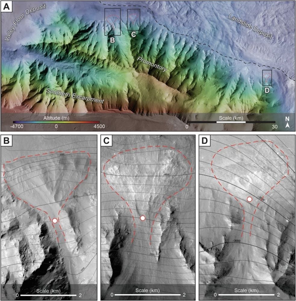 (A) shows where three SFDs are located along the northern margin of the promontory in Southeast Coprates Chasma. The dashed black line indicates the boundary of the deposits. The subsequent panels show them in greater detail. The red lines show their rough boundaries, and the white dots show their apexes. Image Credit: Argadestya et al. 2026
"CaSSIS has been providing high-resolution color images of the surface of Mars since April 2018," said Nicolas Tomas, Professor at the Department of Space Research & Planetary Sciences (WP) at the University of Bern. "The images are regularly used in scientific studies. I am personally very pleased that the images have now also been used in a geomorphological study by the Institute of Geological Sciences," added Thomas, who provided leadership for the development of the CaSSIS camera.
"When measuring and mapping the Martian images, I was able to recognize mountains and valleys that resemble a mountainous landscape on Earth. However, I was particularly impressed by the deltas that I discovered at the edge of one of the mountains," said Argadestya. SFDs are like river deltas, where fan-shaped deposits of sediments form where a river empties into a body of standing water.
"Delta structures develop where rivers debouch into oceans, as we know from numerous examples on Earth," explained study co-author Fritz Schlunegger, Professor of Exogenous Geology at the Institute of Geological Sciences at the University of Bern. "The structures that we were able to identify in the images are clearly the mouth of a river into an ocean," Schlunegger continues.
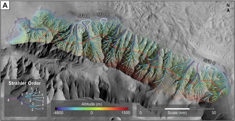 This image shows tributary channels identified in the northward facing promontory of the Southeast Coprates Chasma. The Strahler order in the inset box shows the stream size hierarchy. Image Credit: Argadestya et al. 2026
The SFDs are all at about the same elevation in Valles Marineris, and in previous research on the northern lowlands, an important detail. The bulk of research shows they were deposited between the Late Hesperian period and the Early Amazonian period. The Hesperian spanned from 3.7 billion to 3 billion years ago, and the Amazonian period spans from about 3 billion years ago to the current age. "We consider this as the time with the largest availability of surface water on Mars," the authors write.
Multiple studies have shown that ancient Mars had a massive, perhaps global ocean. This study adds to that weight of evidence by providing clear evidence of ancient coastlines.
"We are not the first to postulate the existence and size of the ocean," Schlunegger said. "However, earlier claims were based on less precise data and partly on indirect arguments. Our reconstruction of the sea level, on the other hand, is based on clear evidence for such a coastline, as we were able to use high-resolution images."
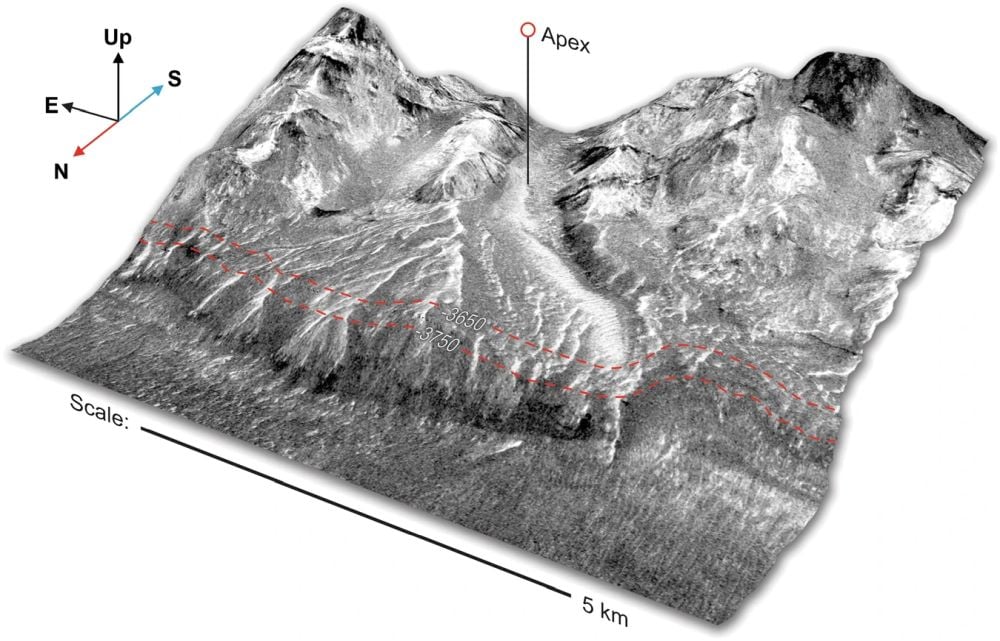 This is an oblique view of a 3D Digital Elevation Model from CaSSIS showing more detail in SFD A. The -3750 and -3650m elevation contours are shown in red dashed lines, indicating the high-water mark of Mars' ancient ocean. Image Credit: Argadestya et al. 2026
The three SFDs in Coprates Chasma aren't the only ancient fan deposits on Mars. There are also some in Capri Chasma, Chryse Chaos, and Hydraotes Chaos. This evidence of an ancient paleoshoreline indicates that an ocean reached the same high level from Valles Marineris to the Northern Lowland.
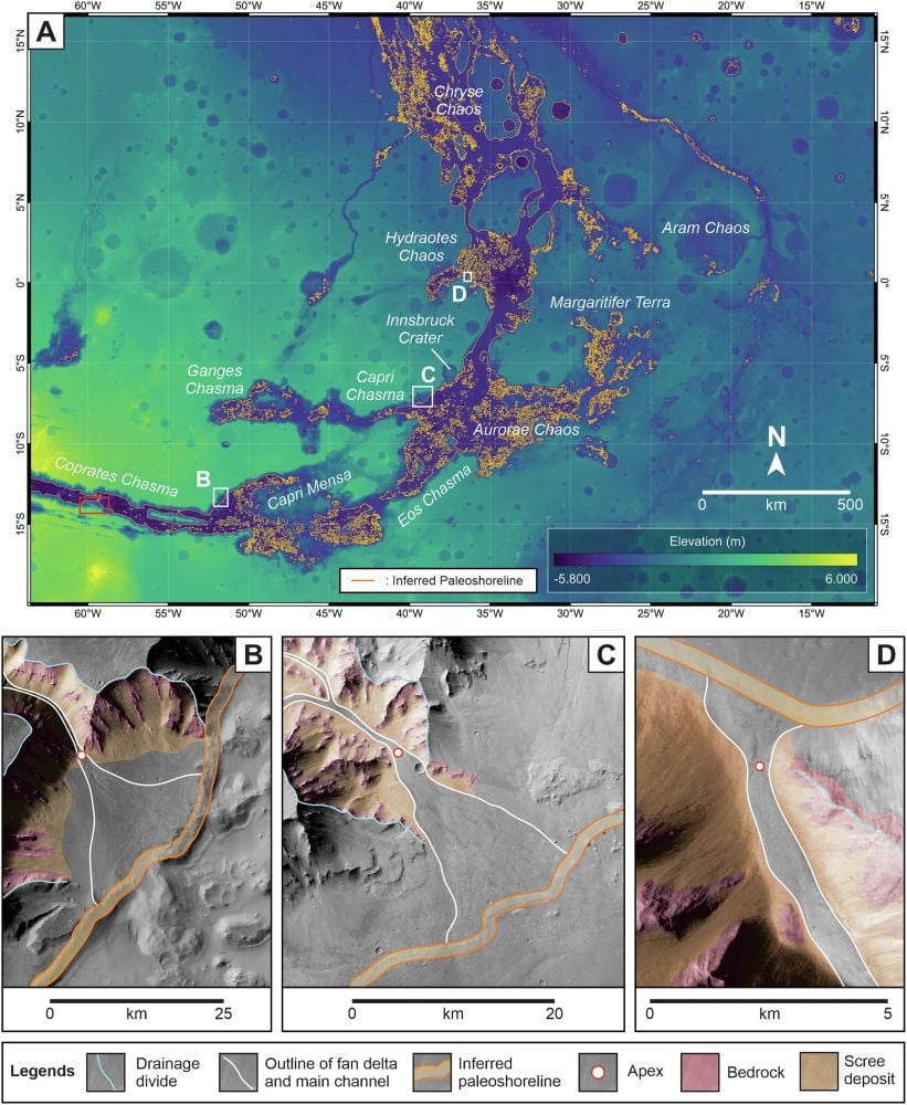 These panels show where an ancient paleoshoreline existed on Mars. (A) shows the westward extension of the inferred paleoshoreline (orange line) identified in the study area (red rectangle) across the Valles Marineris depression into Chryse Chaos, a transitory region between the Southern highlands and the Northern lowlands on Mars. B,C, and D, show more detail for the three SFDs in the study and how they fit in. Image Credit: Argadestya et al. 2026
"With our study, we were able to provide evidence for the deepest and largest former ocean on Mars to date – an ocean that stretched across the northern hemisphere of the planet," said Argadestya.
"In conclusion, the SFDs at the foothills of the Promontory of Southeast Coprates Chasma reflects a period (boundary between the Late Hesperian and the Early Amazonian) with the highest water availability on Mars," the authors write. "We thus consider that our findings on the environmental stage during the Late Hesperian to Early Amazonian will have implications for research on the evidence for potential life on Mars."
