Ice Sculptures Fill The Deepest Parts of Mars
Credit: NASA/JPL/Arizona State University
[/caption]
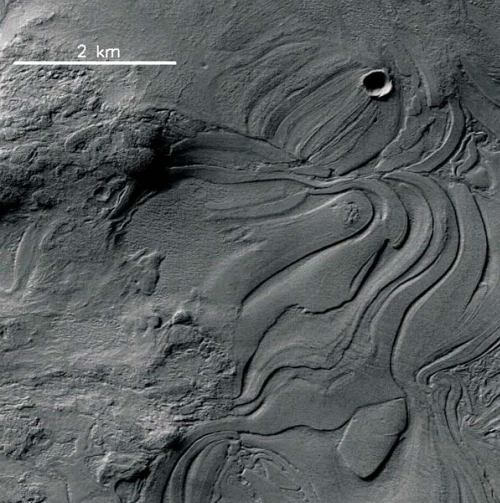
One of the “weirdest and least understood” areas of Mars, the enormous Hellas Impact Basin contains strange flowing landforms that bespeak of some specialized and large-scale geologic process having taken place. The HiRISE camera aboard NASA’s Mars Reconnaissance Orbiter recently captured the image above, showing what’s being called “lava lamp terrain” — stretched and contorted surface that looks like overworked modeling clay or pulled taffy… or, with a bit of imagination, the melted, mesmerizing contents of a party light from another era.
At 1,400 miles (2,300 km) across, Mars’ Hellas Basin is one of the largest impact craters in the entire Solar System. Its vast interior sinks to a depth of about 23,000 feet (7152 meters) below Mars’ average surface elevation (Martian “sea level”, if you will) and thus its floor is often shrouded by haze and dust, making visual imaging difficult.
The “lava lamp” terrain is just one of many different types of landforms that are found in the basin, although many of these banded features are found in the northwest area — which is also the deepest part of the basin. If there had been water in the region at some point in the planet’s history, it would have concentrated there.
Although the texture at first appears as if it could be volcanic in origin, it’s thought that flowing water or ice may actually be the source.
Researchers are currently working to determine how the Hellas Basin became so smoothly sculpted. Nicolas Thomas, Professor of Experimental Physics at the University of Bern, Switzerland, told Universe Today:
“There are a lot of very interesting images from this area and we are trying to get more data (including stereo) to understand better what’s going on and to try to establish what process is responsible for the numerous bizarre features we see. We are hoping to make some more progress in the next few months.”
This hypothesis is also in line with the possibility of Hellas Basin having once been a giant lake.
“Together with the observations of isolated areas and the lack of obvious caldera(s), it is difficult to envisage a volcanic origin for these features and we currently tend towards a mechanism involving ice,” Thomas stated in an abstract of a presentation given at the Europlanet Conference in 2010.
Read the full abstract here, and see this and more high-resolution images from Mars on the HiRISE website.
Recent Posts
New Evidence for Our Solar System’s Ghost: Planet Nine
Does another undetected planet languish in our Solar System's distant reaches? Does it follow a…
NASA Takes Six Advanced Tech Concepts to Phase II
It's that time again. NIAC (NASA Innovative Advanced Concepts) has announced six concepts that will…

China is Going Back to the Moon Again With Chang'e-6
On Friday, May 3rd, the sixth mission in the Chinese Lunar Exploration Program (Chang'e-6) launched…
What Can Early Earth Teach Us About the Search for Life?
Earth is the only life-supporting planet we know of, so it's tempting to use it…
China Creates a High-Resolution Atlas of the Moon
Multiple space agencies are looking to send crewed missions to the Moon's southern polar region…
Dinkinesh's Moonlet is Only 2-3 Million Years Old
Last November, NASA's Lucy mission conducted a flyby of the asteroid Dinkinish, one of the…