Cassini’s View of Jupiter’s South Pole
Jupiter as mapped by Cassini. Image credit: NASA/JPL/SSI Click to enlarge
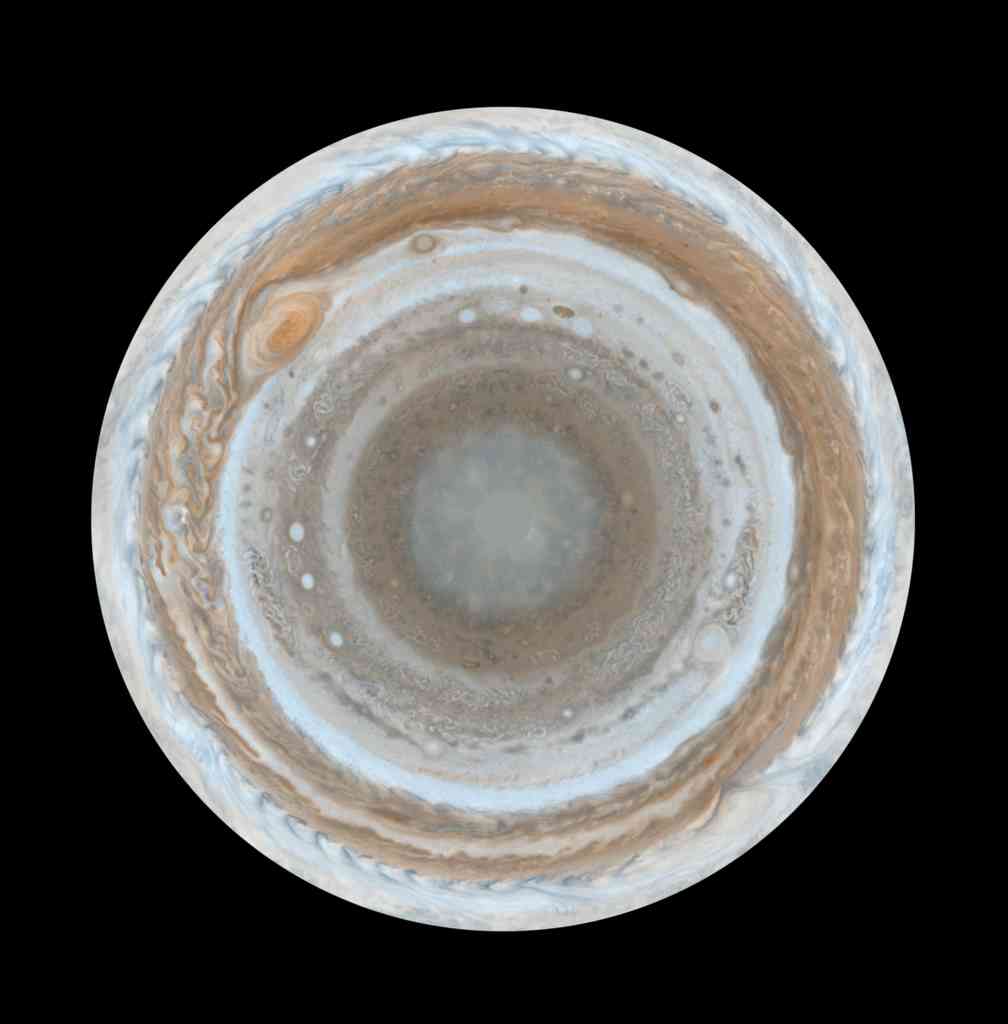
Cassini took many photographs of Jupiter on the way to Saturn, including this unusual montage of its southern pole. This photograph was made up of 36 separate images, stitched together on computer. The planet looks strange because the photo is a polar stereographic projections, which shows the southern pole in the middle, and the equator at the edges. The original images were captured on December 11th and 12th, 2000.
These color maps of Jupiter were constructed from images taken by the narrow-angle camera onboard NASA’s Cassini spacecraft on Dec. 11 and 12, 2000, as the spacecraft neared Jupiter during its flyby of the giant planet. Cassini was on its way to Saturn. They are the most detailed global color maps of Jupiter ever produced; the smallest visible features are about 120 kilometers (75 miles) across. For other maps see PIA07782 and PIA07783. (Related thumbnail images available here.)
The maps are composed of 36 images: a pair of images covering Jupiter’s northern and southern hemispheres was acquired in two colors every hour for nine hours as Jupiter rotated beneath the spacecraft. Although the raw images are in just two colors, 750 nanometers (near-infrared) and 451 nanometers (blue), the map’s colors are close to those the human eye would see when gazing at Jupiter.
The maps show a variety of colorful cloud features, including parallel reddish-brown and white bands, the Great Red Spot, multi-lobed chaotic regions, white ovals and many small vortices. Many clouds appear in streaks and waves due to continual stretching and folding by Jupiter’s winds and turbulence. The bluish-gray features along the north edge of the central bright band are equatorial “hot spots,” meteorological systems such as the one entered by NASA’s Galileo probe. Small bright spots within the orange band north of the equator are lightning-bearing thunderstorms. The polar regions shown here are less clearly visible because Cassini viewed them at an angle and through thicker atmospheric haze.
The round maps are polar stereographic projections that show the north or south pole in the center of the map and the equator at the edge.
The Cassini-Huygens mission is a cooperative project of NASA, the European Space Agency and the Italian Space Agency. The Jet Propulsion Laboratory, a division of the California Institute of Technology in Pasadena, manages the mission for NASA’s Science Mission Directorate, Washington, D.C. The Cassini orbiter and its two onboard cameras were designed, developed and assembled at JPL. The imaging operations center is based at the Space Science Institute in Boulder, Colo.
For more information about the Cassini-Huygens mission visit http://saturn.jpl.nasa.gov . The Cassini imaging team homepage is at http://ciclops.org .
Original Source: NASA/JPL/SSI News Release
Recent Posts
Psyche is Still Sending Data Home at Broadband Speeds
When I heard about this I felt an amused twinge of envy. Over the last…
Uh oh. Hubble's Having Gyro Problems Again
The Hubble Space Telescope has gone through its share of gyroscopes in its 34-year history…

Astronomers Will Get Gravitational Wave Alerts Within 30 Seconds
Any event in the cosmos generates gravitational waves, the bigger the event, the more disturbance.…
Next Generation Ion Engines Will Be Extremely Powerful
During the Space Race, scientists in both the United States and the Soviet Union investigated…
Neutron Stars Could be Capturing Primordial Black Holes
The Milky Way has a missing pulsar problem in its core. Astronomers have tried to…
Japan’s Lunar Lander Survives its Third Lunar Night
Space travel and exploration was never going to be easy. Failures are sadly all too…