Spectacular Footage, Satellite Images of Eyjafjallajokull Volcano in Iceland
NASA's Terra Satellite captured this image on April 15, 2010 of the volcano and resulting ash plume. NASA image by Jeff Schmaltz, MODIS Rapid Response Team at NASA GSFC.
A volcano under a glacier in Iceland erupted Wednesday, melting ice, shooting smoke and steam into the air and forcing hundreds of people to leave their homes. The resulting ash plume has also halted air traffic over much of Europe. Scientists said the eruption under the ice cap was 10 to 20 times more powerful than an eruption from the that happened from the Eyjafjallajokullin Volcano late last month. “This is a very much more violent eruption because it’s interacting with ice and water,” said Andy Russell, an expert in glacial flooding at the University of Newcastle in northern England, in an article on the CBC website. The dramatic footage in the video here was released today, April 15, and satellite images, below, show how far the ash plume has traveled.
[/caption]
The iceland volcano sent a plume of ash and steam across the North Atlantic prompting airspace closures in the United Kingdom, Ireland, France, and Scandinavia, which then had a ripple effect, disrupting flights to and from other countries as well. Authorities could not say how long the airspace closure would last, and the ash’s spread threatened to force closures of additional airspace over the coming days.
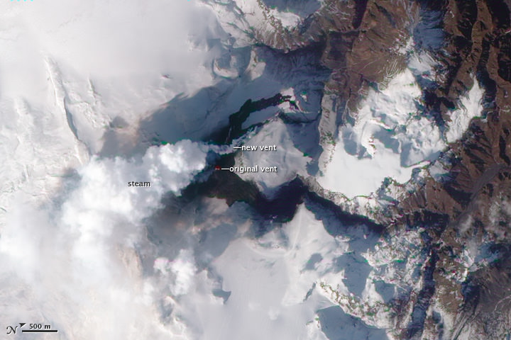
This natural-color satellite image shows the area of the eruption on April 1, when a new vent opened up. The image was acquired by the Advanced Land Imager (ALI) aboard NASA’s Earth Observing-1 (EO-1) satellite.
The volcano, about 120 kilometres east of Reykjavik, erupted March 20 after almost 200 years of silence.
Watch an animation from ESA of how the plume traveled.
Pall Einarsson, a geophysicist at the University of Iceland, said magma was melting a hole in the thick ice covering the volcano’s crater, sending water coursing down the glacier, and causing widespread flooding.
Iceland’s main coastal ring road was closed near the volcano, and workers smashed a hole in the highway in a bid to give the rushing water a clear route to the coast and prevent a major bridge from being swept away.
Recent Posts
Enceladus’s Fault Lines are Responsible for its Plumes
The Search for Life in our Solar System leads seekers to strange places. From our…
Lunar Explorers Could Run to Create Artificial Gravity for Themselves
Few things in life are certain. But it seems highly probable that people will explore…

This is an Actual Picture of Space Debris
Space debris is a growing problem, so companies are working on ways to mitigate it.…
Insanely Detailed Webb Image of the Horsehead Nebula
Few space images are as iconic as those of the Horsehead Nebula. Its shape makes…
Binary Stars Form in the Same Nebula But Aren’t Identical. Now We Know Why.
It stands to reason that stars formed from the same cloud of material will have…
Earth Had a Magnetosphere 3.7 Billion Years Ago
We go about our daily lives sheltered under an invisible magnetic field generated deep inside…