The Inauguration of President Barack Obama from Space
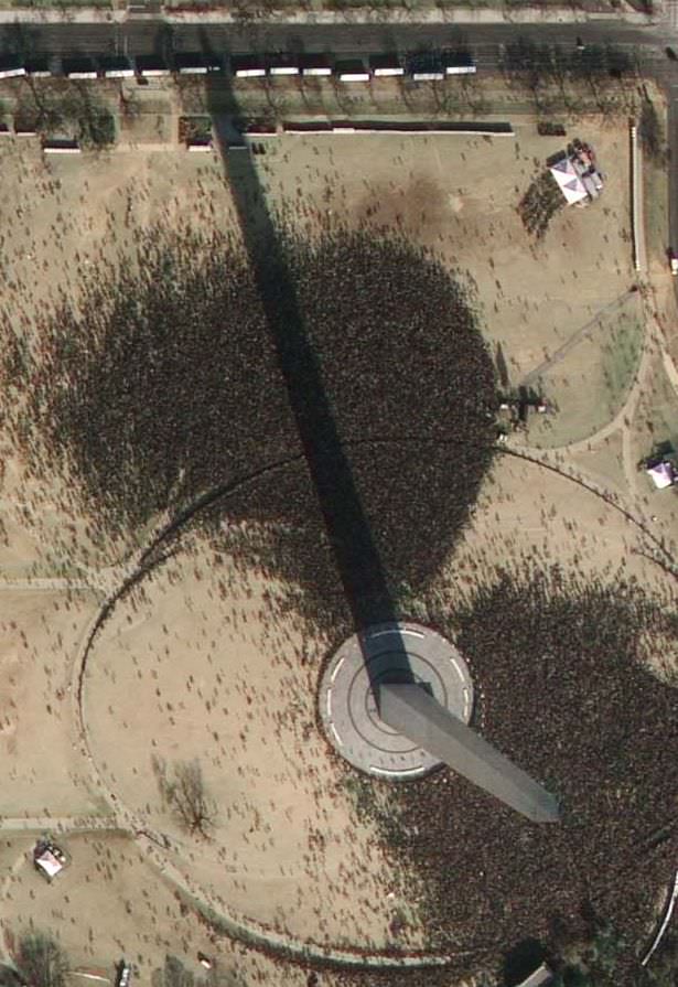
Today's inauguration as seen from over 400 miles high (GeoEye)
[/caption]
Travelling at 17,000 mph at an altitude of 423 miles, the 4,300 lb GeoEye-1 snapped a very high resolution image of Washington D.C. just before Barack Obama became the 44th President of the United States. Looking like crowds of ants vying for space around Capitol Hill and the White House, hundreds of thousands of spectators gathered to watch this historic day unfold…
GeoEye commissioned this orbital photograph in response to numerous media requests. The satellite is able to attain a resolution of 0.41 meters, although this preliminary view has been shrunk by media sources for distribution. It does however, capture a unique view of what is a historic day not only for the US but for the World.
More information about GeoEye-1:
“In August 2008, Google signed a deal with the satellite imagery company GeoEye for exclusive use of the images produced by the company’s new GeoEye-1 satellite. GeoEye-1 was launched on board a United Launch Alliance Delta II rocket from Vandenberg Air Force Base, California, on September 6th 2008. The satellite is currently in a Sun-synchronous orbit, over 400 miles above the surface of Earth, imaging the surface in unprecedented detail. A US government licence actually limits the resolution of available images to 0.5 metres (the camera on GeoEye-1 can attain a resolution of 0.41 metres). GeoEye-1’s competitors can resolve objects down to 0.6 metres at the smallest. The GeoEye products are currently used by Google for several projects, such as Google Earth and Google Maps.”
–Universe Today article, “Google Satellite” Will Have an Orbital View Over Obama’s Inauguration
Source: CNET
Recent Posts
China Creates a High-Resolution Atlas of the Moon
Multiple space agencies are looking to send crewed missions to the Moon's southern polar region…
Dinkinesh's Moonlet is Only 2-3 Million Years Old
Last November, NASA's Lucy mission conducted a flyby of the asteroid Dinkinish, one of the…

The Universe Could Be Filled With Ultralight Black Holes That Can't Die
Steven Hawking famously calculated that black holes should evaporate, converting into particles and energy over…
Starlink on Mars? NASA Is Paying SpaceX to Look Into the Idea
NASA has given the go-ahead for SpaceX to work out a plan to adapt its…
Did You Hear Webb Found Life on an Exoplanet? Not so Fast…
The JWST is astronomers' best tool for probing exoplanet atmospheres. Its capable instruments can dissect…
Vera Rubin’s Primary Mirror Gets its First Reflective Coating
First light for the Vera Rubin Observatory (VRO) is quickly approaching and the telescope is…