
Hurricane Ike is bearing down on the US gulf coast, and even before landfall, is causing problems. Nearly 1 million people along the Texas coast have been ordered to evacuate, the other 3 million people in the Houston metro area have been asked not to leave, in hopes of avoiding the panic of three years ago, when evacuations ordered in advance of Hurricane Rita sent millions onto highways causing traffic jams and deadly accidents. The airports in Houston will close tomorrow, and NASA’s Johnson Space Center closed today.


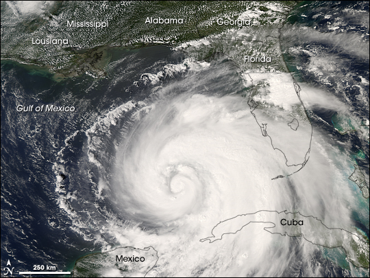
TRMM (Tropical Rainfall Measuring Mission) spacecraft observed this view of Hurricane Ike on September 10, 2008 at 1745 UTC. The storm was a category 2 hurricane with sustained winds of 85 knots (97.75 mph) and a pressure reading of 958 millibars. At this time, the storm has two nearby well-defined wind maxima of roughly equal strength. There is a 17 km tower in the outer eye.
Click here for an animation from the TRMM spacecraft data.
The astronauts on board the International Space Station had this incredible view of the hurricane as it approached the Gulf Coast.

Ike was a Category 4 storm before its passage over Cuba stripped it of some of its power. It re-emerged in the Gulf of Mexico as a Category 1 storm and re-strengthened.
As of 10:00 a.m., Sept. 11, hurricane warnings are up from Morgan City Louisiana to Baffin Bay, Texas. Hurricane conditions could reach the coast within the warning area by late Friday, Sept. 12.
Ike is a Category 2 hurricane with maximum sustained winds near 100 mph. He is forecast to strengthen to a Category 3 storm before reaching the Texas coastline. Ike is moving west-northwest near 10 mph and will be near the coast late on Sept. 12, however, because Ike is large, tropical storm force winds will be felt far in advance.
Sources: NASA’s ISS Page, NASA Earth Observatory Page, The Weather Channel. Here are even more hurricane photos and hurricane images.
*whistles*
That’s one BIG storm…
Looks like cake 😀 yum
With all the grandeur of the universe paraded before our eyes on these pages every day, I think we sometimes forget that there still images of this planet that can inspire the same awe and wonder.
Please insert an “are” between “there” and “still”. (I responded to this while still under the influence of all that awe and wonder!)
Beautiful and yet so dangerous at the same time.
Wow. I wonder if you can see it from Jupiter (the way we can see the Great Red Spot)?
It looks like a monster and I’m glad we have nothing like this in Australia! How do you guys cope with all these hurricanes? The power of nature is awe inspiring!! Wonderful!!
Am at the Island of Puerto Ruerto Rico and let me tell you somthing the force of hurracaine Hugo was just incredible you can see the trees side to side until they broke or just lay down to the floor. Imagine a huge roof of iron steel brake like a pice of paper, well thats the power of a hurricane force winds. The sound was like a whistle all the time you herd the foce of the wind coming like you can say hey its there is coming wash out. Ufffff it was terrible.
So – all those Texan republican voting global warming deniers are about to get hit by a freak hurricane.
Try denying this one.
I think Sarah Palin looks like she’s doing a Lens Crafters commercial.
We duck and cover Sally, either that or run to a safer place. That’s the only thing you can do if you want to survive. I was really young when Hugo came through and even though we stayed in our house, it did a lot of damage to our house, even though by the time it got to us in NC, it wasn’t as bad as it was when it initially hit land. As for the rest of the hurricane’s, we’ve been fortunate enough to not have been hit by major hurricanes making landfall here in NC. They are amazing in how they operate, what amazes me the most is that the winds are SO high but yet they move so slow!!!
This grandeur is contrasted by the 140,000 fools who ignored the order to evacute. Over one other of every 8 people in Galveston stayed when the Weather Service promise “certain death”.
We may have the large number of Darwin award winners in history. Only in Texas!
Only in Texas! What an idiot you are. The people that didn’t evacuate are the same liberal welfare check morons that didn’t get out of New Orleans when Hurricane Katrina hit!
Only hard working Republican conservative taxpaying Americans have the capacity to evacuate from a natural disaster like this.
Get a life.
marcellus:
You seem to be a little out of touch.
The Republicans have claimed tredneck welfare check morons as their constiutency.
See, since they can’t win on the merit of their leadership and the strength of their ethics and morals, they play the religion and gay-bashing card and redneck idiots fall in line.
Just thought you should know. Be happy! Your party has the rich suppressive assholes AND the retarded religious zealot racists, sexists, and homophobes.
What a grand variety of conversations you must be able to choose from at the conventions..
Please someboby send me some pictures from the port of Port Arthur, after the Hurricane Ike, to have an idea about the damages.
Thank you and regards
I was in Cuba on holiday when Ike hit us. Terrifying but an awsome experience at the same time. all of us were lucky to get out of the hotel alive.
Im from Scotland and used to high winds…this is in a league all of its own!
A beutifull country totally destroyed in one night!
Poeple have asked me what it was like…Words cannot describe what a sustained 100pmh+ wind is like for hours on end…thats without the 140mph gusts!!!
The eye was very eery…quiet and quite calm..but after 30mins of realitive calmness it took only about 5mins for wind to get back up to full force again. At that point…we barricaded ourselves in the bathroom as instructed. Our patio doors were threatening to blow in.
Many peoples rooms in the hotel had the whole window frames of there patio doors blown in.
Coral had been blown up from the wrecked reef 500yrds offshore and smashed windows….4 floors up!
How can wind that strong be described!
The wierd thing is….i would love to experience it again…perhaps i need to change my career and become a storm chaser…but the clips you see on the news are not filmed when the strongest winds are blowing but probably a few hours before they hit.
Anyone else had similar experiences?