Satellites often offer new perspectives when they launch. Sometimes because of the location they are placed in - sometimes because of their instrumentation. A new satellite by a consortium of European companies and agencies now provides a new perspective on one of the most powerful and fleeting natural phenomena - lightning.
The Meteostat Third Generation (MTG) satellite was launched back in December and actually contains not one but two novel imaging instruments. The Flexible Combined Imager excels at producing crystal clear images that can be combined into some spectacular movies - the first of which were released in April.
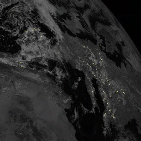
But more recently, a team of ESA and the European Organisation for the Exploitation of Meteorological Satellites (Eumetsat) released a series of images from the MTG's other sensor - the Lighting Imager. The results include spectacular still-frame photos, which are then combined into an even more spectacular video.
Video footage from one of Lightning Imager's cameras.Credit - ESA YouTube ChannelThe imager itself is made up of four different cameras. Combined, they cover Europe, Africa, the Middle East, and parts of South America, all from an altitude of around 36,000 km. Simonetta Cheli, ESA's Direct of Earth Observation Programmes, points out that that covers over 84% of the Earth's disc, at least on the side it's facing. Each camera can also capture 1000 images a second, allowing them to see even the briefest of lightning flashes.
That would also result in an overwhelming amount of data, so MTG does much of the image processing locally and only sends the relevant bits back to Earth. The algorithm that does so, along with the imager itself, was developed by Leonardo Space, a company based in Italy specializing in developing satellite instruments.
Magic truly happens when the MTG combines data from the Lightning image with the Flexible Combined Imager. With those two powerful tools, it can create some truly dramatic footage. But besides just being nice to look at, the data can also be used for both scientific and meteorological purposes. It is now much easier to track storms and warn regions that might be threatened by severe weather. Over time, those weather patterns will also become clearer, allowing meteorologists to predict evolving storm fronts more accurately.
Lightning over Central AfricaCredit - ESA YouTube ChannelFor now, though, this is just the beginning of MTG's journey. Despite releasing these spectacular images, it is technically still in its commissioning phase. It plans to start full operations in early 2024. And even more impressively, it plans to operate for over 20 years, providing these insights into severe storms and weather patterns. Over that time, it will be joined by other meteorological satellites with other sensing systems, including some that will utilize Infrared Sounders and an Ultraviolet Visible Near-Infrared spectrometer providing even more new perspectives for both casual appreciation and hardcore scientific study.
Learn More:
ESA - European satellite strikes lightning
ESA - New weather satellite reveals spectacular images of Earth
ESA - Lightning Imager
UT - Lightning From Space!
Lead Image:
Video released from Lightning Imager showing lightning strikes at night.
Credit - ESA
