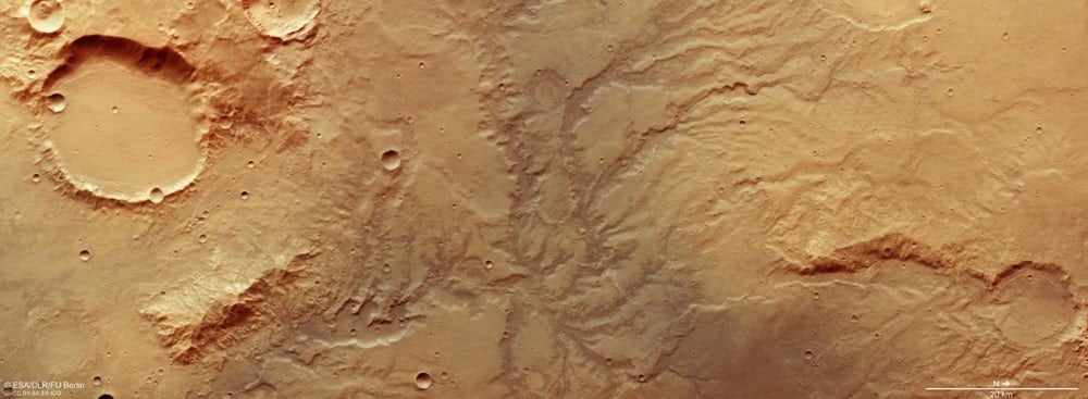
Orbiters are giving us a chance to study the surface of Mars closely, and some of the features that pop to prominence are dry river channels. There are over 10,000 of them. But a new study suggests that glaciers on ancient Mars are responsible for many of them.
According to the study, those glaciers and the water flowing under them are resonsible for carving out some of those riverbeds, rather than free-flowing rivers.
We've been looking at pictures of the Martian surface for several decades, and now we have a keen, bird's eye view of things. Mars features lots of dry river valleys, and the conclusion has been that the planet had to be warm and wet in the past. There was ample running water, and even oceans. But this new study took a closer look at all those valleys and realized they took many different forms.
The new study is titled " Valley formation on early Mars by subglacial and fluvial erosion. " The lead author is Anna Grau Galofre, former PhD student in the University of British Columbia's Department of Earth, Ocean and Atmospheric Sciences. The study is published in the journal Nature Geoscience.
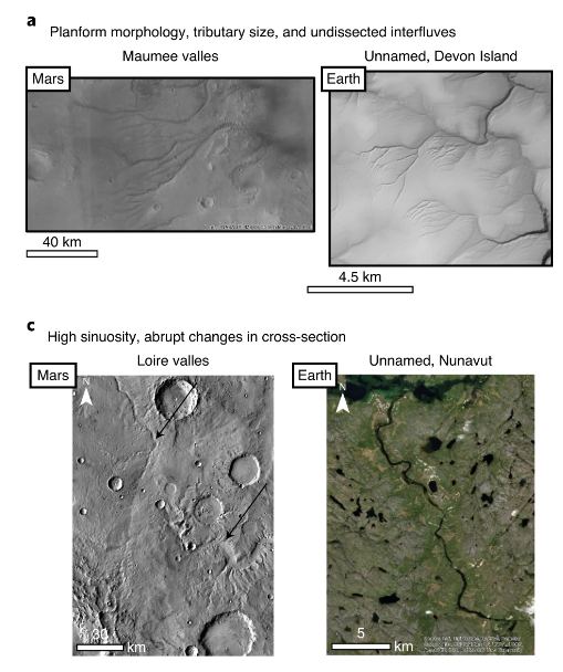
Many studies of Martian valleys have interpreted them to be a result of free-flowing surface water, or rivers. But in the intro to their paper, the researchers write that "... the morphological variability of valley networks suggests that multiple erosional processes were at play. On Earth, water can erode through the action of surface runoff, but also by glacial processes and when confined in drainage channels beneath ice sheets."
In their research, the authors looked at more than 10,000 Martian valleys, a proposition that was impossible not too long ago. To analyze the valleys, they developed new techniques and models, largely based on the characteristics of valleys on Earth. Their results suggest that ancient Mars might not have been as warm and wet as we thought.
"For the last 40 years, since Mars's valleys were first discovered, the assumption was that rivers once flowed on Mars, eroding and originating all of these valleys," says Grau Galofre in a press release. "But there are hundreds of valleys on Mars, and they look very different from each other. If you look at Earth from a satellite you see a lot of valleys: some of them made by rivers, some made by glaciers, some made by other processes, and each type has a distinctive shape. Mars is similar, in that valleys look very different from each other, suggesting that many processes were at play to carve them."
On Mars, valley networks are ancient, formed about 3.9 to 3.5 billion years ago. They formed in The bulk of Mars' valleys are in the southern hemisphere highlands, a geography that dominates two thirds of the Martian surface.
A remote island in Canada's north played a central role in this work. Devon Island is the world's largest uninhabited island, and part of the Arctic Archipelago. Scientists are interested in it because in many ways, it resembles the surface of Mars; especially the island's Haughton Crater. The island is considered a "Mars analog" and is used to research the challenges of exploring Mars.
"Devon Island is one of the best analogues we have for Mars here on Earth--it is a cold, dry, polar desert, and the glaciation is largely cold-based," says co-author Gordon Osinski, professor in Western University's department of earth sciences and Institute for Earth and Space Exploration.
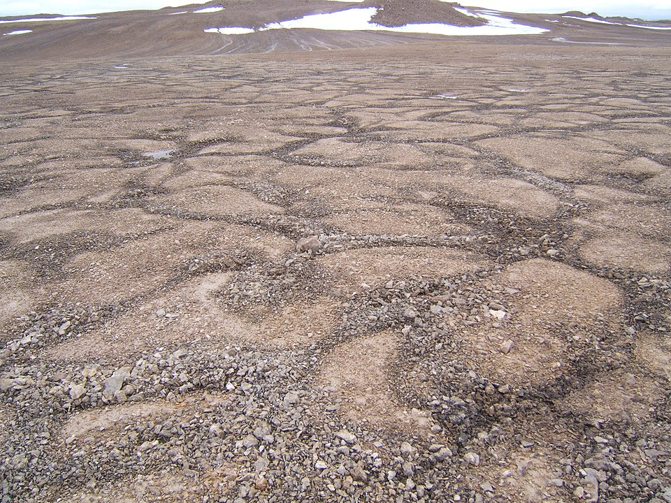
Devon Island is home to sub-glacial channels that resemble some of the valleys on Mars. That similarity is partly what inspired the researchers to do this work. They used an algorithm that compared channels on Mars and Earth, and to infer their underlying causes. Their results are the first to show how valleys on Devon Island and on Mars could have formed through the same process.
"The findings demonstrate that only a fraction of valley networks match patterns typical of surface water erosion..."Mark Jellinek, Co-Author, professor, UBC Department of Earth, Ocean and Atmospheric Sciences
"These results are the first evidence for extensive subglacial erosion driven by channelized meltwater drainage beneath an ancient ice sheet on Mars," says co-author Mark Jellinek, professor in UBC's department of earth, ocean and atmospheric sciences. "The findings demonstrate that only a fraction of valley networks match patterns typical of surface water erosion, which is in marked contrast to the conventional view. Using the geomorphology of Mars' surface to rigorously reconstruct the character and evolution of the planet in a statistically meaningful way is, frankly, revolutionary."
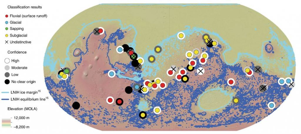
The team analyzed 66 valley systems, containing over 10,000 individual valleys. Of those 66, they found that 22 of them were created by sub-glacial erosion. Nine are best explained by glacial erosion, three are best explained by sapping erosion, and another 18 are indistinct. In those 18, it's likely that the detail of their morphology has been erased over billions of years, making it difficult to understand how they were created.
In some ways, these results collide with our understanding of ancient Mars as a warmer, wetter place. In their paper, the authors write that "Previous interpretations of the geological record require precipitation and surface water runoff to form the valley networks, in contradiction with climate simulations that predict a cold, icy ancient Mars."
The warm, wet ancient Mars scenario has a few problems. The main one concerns the Sun. Billions of years ago, early in the Solar System's history, the Sun was cooler than it is now, and Mars is further away than Earth. How could it have been warm and wet?
According to lead author Galofre, climate modelling shows that ancient Mars must have been cooler. Models point to a period of time called the Late Noachian Icy Highlands (LNIH.) The Noachian period spanned from about 4.1 billion to 3.7 billion years ago. It roughly coincided with the appearance of life here on Earth.
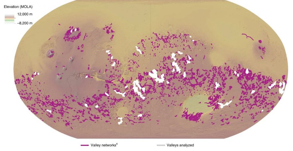
As the figure below shows, sub-glacial river valleys are mostly located between the LNIH ice margin and the LNIH equilibrium line. "Such a spatial distribution is consistent with theory and observations of subglacial channel origin: a meltwater-supply increase below the equilibrium line altitude combined with low sliding rates and enhanced basal pressure gradients drive subglacial channelization," the authors write.
During the LNIH, according to models, Mars was cold and icy. Yet Mars is clearly covered in what looks like dried river beds from that time period. The fact that the models don't agree with the observations is partly what motivated this study.
"Climate modelling predicts that Mars' ancient climate was much cooler during the time of valley network formation," says Grau Galofre, currently a SESE Exploration Post-doctoral Fellow at Arizona State University. "We tried to put everything together and bring up a hypothesis that hadn't really been considered: that channels and valleys networks can form under ice sheets, as part of the drainage system that forms naturally under an ice sheet when there's water accumulated at the base."
Previous studies have wrestled with the idea that Martian river valleys formed when Mars was very cold. One study suggested that there was still some seasonal melting during that period, in which massive amounts of ice melted and flowed across the surface, creating river valleys.
The authors say that their results make "A morphological case for a glaciated early Mars." They also write that it "alters the current understanding that all Martian valley networks originated by surface runoff and provides geomorphological support for the presence of ice sheets on early Mars, which reconciles climate predictions with observations from the geological record."
There are other implications for an ancient Mars with prevalent glaciers. The space under all that ice would've been a stable environment for life. Not only would there have been lots of liquid water, there would've been protection from the Sun's radiation, long after Mars' protective magnetic shield had disappeared.
Now that the team of researchers have developed their detailed model of valley morphology, they intend to use it study Earth's history.
"Currently we can reconstruct rigorously the history of global glaciation on Earth going back about a million to five million years," said co-author Jellinek. "Anna's work will enable us to explore the advance and retreat of ice sheets back to at least 35 million years ago--to the beginnings of Antarctica, or earlier--back in time well before the age of our oldest ice cores. These are very elegant analytical tools."
More:
- Press Release: Early Mars was covered in ice sheets, not flowing rivers
- Published Research: Valley formation on early Mars by subglacial and fluvial erosion
- Universe Today: Mars Had Way More Water on its Surface Than We Thought
