More Satellite Images of China’s Earthquake
Beichuan Region of China, before and after Earthquake. Image credit: Formosat 2
More satellite images have been released portraying the devastation caused by the May 12, 2008 earthquake that struck China’s Sichaun Basin. This pair of images, captured by Taiwan’s Formosat-2, illustrates the challenges faced by rescuers bringing equipment and supplies to survivors of the massive 7.9-magnitude earthquake. The top “before” image from 2006 shows the tree-covered mountain terrain of China’s Beichuan County. A river curves along the base of the mountain, and a road follows the banks of the river.
In the lower image, taken on May 14, 2008, the landscape is almost unrecognizable. A landslide engulfed the entire mountainside, turning its green slopes brown. Both the road and the river are entirely gone, buried under the rubble, which rises in a mound up the opposite slope. Landslides, flooding and buckled roads have made travel within quake-affected regions difficult.
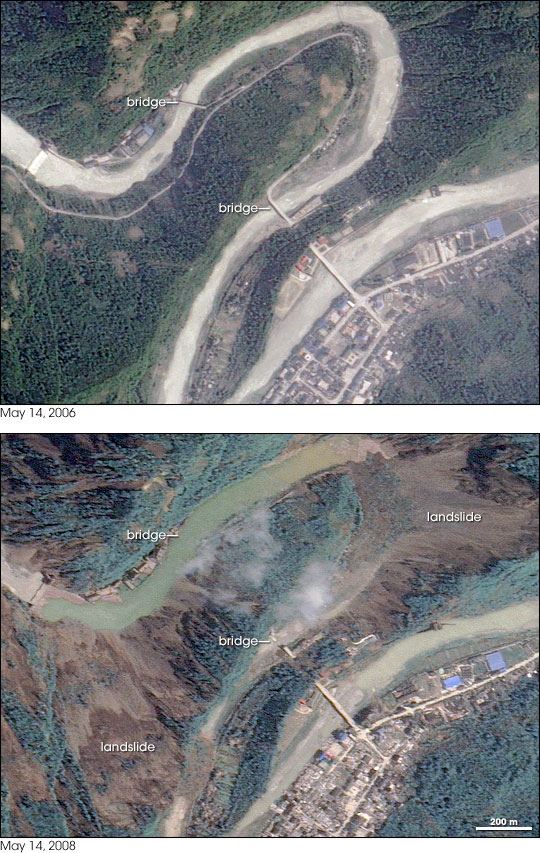
Landslides have created earthen dams, and new lakes were formed overnight. This pair of high-resolution images from Taiwan’s Formosat-2 satellite show a “before” and “after” comparison from May 14, 2006 (top),and May 14, 2008 (bottom.) Several landslides, a collapsed bridge, and a bridge submerged by a newly formed lake are visible in the “after” the earthquake image.
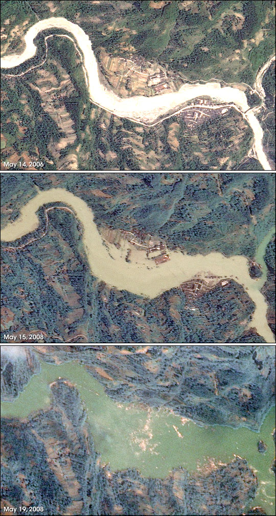
Finally, this bottom series of images show how devastation continues to occur as the earthquake and its aftershocks has sent earth and rock tumbling down mountains into rivers, creating natural dams behind which lakes quickly built up. The first, a “before” image taken in 2006, show normal springtime conditions.On May 15, 2008, three days after the initial earthquake, both the bridge and the roads it connected had disappeared under murky water. Some sections of the villages remained above the waterline, as did portions of the roads leading to the villages. The tops of trees, perhaps on slightly higher ground, formed tiny islands near the shores of the growing lake.
Formosat-2 took the final image on May 19, 2008. By this time, water levels in the earthquake lake had risen enough to immerse both villages and the entire road network. Tan debris floats on the surface of the water, concentrated over the locations of the villages.
Earthquake-created dams present a dual danger. Apart from the upstream floods that occur as a lake builds behind the natural dam, the piles of rubble that form the dam may be unstable. Another quake or simply the pressure of water behind it could burst the dam, sending a wall of water downstream. Downstream floods may also occur when water begins to cascade over the top of the dam. Thousands of people were evacuated from Beichuan on May 17 when one such lake threatened to burst, said China Daily.
Original News Source: NASA’s Earth Observatory
Recent Posts
Did Earth’s Multicellular Life Depend on Plate Tectonics?
How did complex life emerge and evolve on the Earth and what does this mean…
Hubble Sees a Brand New Triple Star System
In a world that seems to be switching focus from the Hubble Space Telescope to…

The Venerable Hubble Space Telescope Keeps Delivering
The world was much different in 1990 when NASA astronauts removed the Hubble Space Telescope…
The BepiColombo Mission To Mercury is Losing Power
BepiColombo is a joint ESA/JAXA mission to Mercury. It was launched in 2018 on a…
Astronauts Could Deploy Extra Arms to Stay Stable on the Moon
Walking along on the surface of the Moon, as aptly demonstrated by the Apollo astronauts,…
Not All Black Holes are Ravenous Gluttons
Some Supermassive Black Holes (SMBHs) consume vast quantities of gas and dust, triggering brilliant light…