With three orbiters and two rovers currently at Mars, there are always interesting images coming back from the Red Planet. Here's a round-up of the latest images from the five different spacecraft. First up is a fascinating image from the Mars Odyssey spacecraft of dust devil tracks. It's amazing just how many tracks there are in just this one image. Martian dust devils can be up to fifty times as wide and ten times as high as dust devils seen on Earth. This image was taken by Odyssey's Thermal Emission Imaging System (THEMIS), and shows an area in the south polar region, just east of Daly Crater. Resolution is about 17 meters per pixel.
Original Image link
.
NASA's Mars Exploration Rover Spirit has this view northward from the position at the north edge of the "Home Plate" plateau where the rover will spend its third Martian winter. And no, that's not a pool of water in the image. It's just rippled sand in the "El Dorado" sand dune field, and the image is shown in false color.
Husband Hill is on the horizon. Spirit used its panoramic camera (Pancam) to capture this image during the rover's 1,448th Martian day, on January 29, 2008.
Original image link.
This view from the Opportunity rover shows a close-up of bedrock from the inside of Victoria Crater, where the rover is currently studying a stratigraphic layer of rocks. This area is informally named "Lyell," which is the lowermost of three layers the rover has examined at a bright band around the inside of the Crater.
Opportunity used its panoramic camera (Pancam) to capture this image with low-sun angle at a local solar time of 3:21 p.m. during the rover's 1,433rd Martian day, on February 4, 2008. This image, too, is in false color to highlight the ripples and bands in the bedrock.
Original Image link.
ESA's Mars Express took snapshots of Candor Chasma, a valley in the northern part of Mar's huge canyon, Valles Marineris, as it was in orbit above the region on 6 July 2006.
The High Resolution Stereo Camera on the orbiter obtained the data,with a ground resolution of approximately 20 m/pixel. Candor Chasma lies at approximately 6° south and 290° east.
Original Image link.
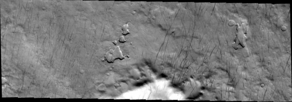
This image taken by the Mars Reconnaissance Orbiter (MRO) shows a volcanic vent. A volcanic vent is an opening in the crust of a planet that emits lava (molten rock) and volcanic gases. The rough texture of the plains surrounding the vent iindicates that it is lava.
There is a large number of snake-like features emanating from the vent. The parallel lines that outline the features are levees, which mark the edges of channels that carried molten lava. As lava flows, it moves slowest at its edges and bottom because the lava sticks to the non-flowing rocks, and as the lava slows, it cools off and hardens.
Levees form when the sides harden but the center of the flow keeps moving. As the eruption episode ends, and the lava drains, the center is left lower than the sides producing these high-standing structures. Of course, these lava flows are very, very old.
Original Image page.