Detailed Gravity Maps of the Earth will be Coming Soon
How high is Mount Everest? Really high? Nearly 9,000 metres? Come on, be precise. Don’t worry if you can’t, even geographers can’t agree. In 1999, the mountain’s height was stated as 8,850 metres, and then a Chinese survey in 2005 calculated it to be 8,844.43. That might not sound like much of a difference, but for scientists, it’s just too much uncertainty. Good thing a new spacecraft will be launching soon to settle the question once and for all.
ESA’s gravity field and steady-state Ocean Circulation Explorer (GOCE) is scheduled to blast off in early 2008. This sensitive satellite will then measure the Earth’s gravity field and geoid with unparalleled precision.
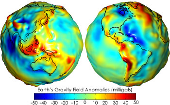
What’s the geoid? That’s a measure of the Earth’s gravity field at every point across the planet. Imagine you were able to extend the oceans across the surface of the entire planet, perhaps by cutting canals across the continents. This is how geographers can measure the height of a point above sea level, even when you’re thousands of kilometres away from the nearest ocean.
The geoid isn’t flat. Instead, it rises and falls depending on the local gravity at that exact point. If you’re traveling across the ocean on ship, you don’t stay at the exact same distance from the Earth’s centre point. Instead it varies, depending upon where on Earth you are. Pass by the Hawaiian islands, and their mass will draw the water up, raising sea level. Not a lot – the total variation is less than 200 metres, compared to a perfect mathematical ellipsoid. As you can imagine, the shape of this geoid is important to scientists.
When GOCE launches, it’ll fly at an altitude of 260 km. Instead of a traditional satellite, it’s streamlined, with fins that keep it stable as it passes through the last remnants of the Earth’s atmosphere. It will measure the Earth’s gravity to within an accuracy of 1-2 cm. In other words, they should be able to provide an answer to the Everest height question, once and for all. Not to mention, an accurate altitude for every other spot on Earth.
Here are some additional stories on measuring the Earth’s gravity, with GOCE and the previously launched GRACE satellite.
- Earthquake Should Show a Gravity Scar
- Antarctica is Melting Faster
- Grace Satellites Launched
- Tracking Rainfall, Just By its Gravity
Original Source: ESA News Release
Recent Posts
Enceladus’s Fault Lines are Responsible for its Plumes
The Search for Life in our Solar System leads seekers to strange places. From our…
Lunar Explorers Could Run to Create Artificial Gravity for Themselves
Few things in life are certain. But it seems highly probable that people will explore…

This is an Actual Picture of Space Debris
Space debris is a growing problem, so companies are working on ways to mitigate it.…
Insanely Detailed Webb Image of the Horsehead Nebula
Few space images are as iconic as those of the Horsehead Nebula. Its shape makes…
Binary Stars Form in the Same Nebula But Aren’t Identical. Now We Know Why.
It stands to reason that stars formed from the same cloud of material will have…
Earth Had a Magnetosphere 3.7 Billion Years Ago
We go about our daily lives sheltered under an invisible magnetic field generated deep inside…