Artist's impression of Mars during the Noachian Era. Credit: Ittiz/Wikipedia Commons
All across the Martian surface, there are preserved features that tell the story of what Mars once looked like. These include channels that were carved by flowing water, delta fans where water deposited sediment over time, and lakebeds where clay and hydrated minerals are found. In addition to telling us more about Mars’ past, the study of these features can tell us about how Mars made the transition to what it is today.
According to new research led by Brown Ph.D. student Ben Boatwright, an unnamed Martian crater in Mars southern highlands showed features that indicate the presence of water, but there is no indication of how it got there. Along with Brown professor Jim Head (his advisor), they concluded that the crater’s features are likely the result of runoff from a Martian glacier that once occupied the area.
Orbiters are giving us a chance to study the surface of Mars closely, and some of the features that pop to prominence are dry river channels. There are over 10,000 of them. But a new study suggests that glaciers on ancient Mars are responsible for many of them.
According to the study, those glaciers and the water flowing under them are resonsible for carving out some of those riverbeds, rather than free-flowing rivers.
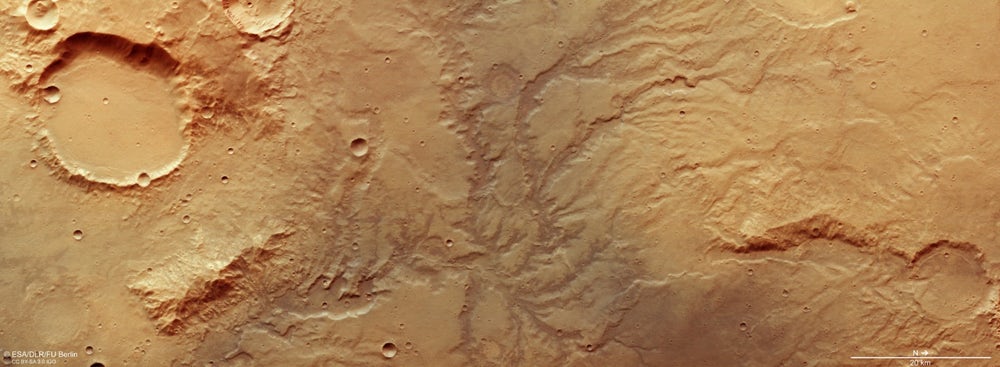
Colour-coded topographic view of the Colles Nili region, showing the relative heights and depths of terrain. Credit: ESA/DLR/FU Berlin
In the northern hemisphere of Mars, between the planet’s southern highlands and the northern lowlands, is a hilly region known as Colles Nilli. This boundary-marker is a very prominent feature on Mars, as it is several kilometers in height and surrounded by the remains of ancient glaciers.
And thanks to the Mars Express mission, it now looks like this region is also home to some buried glaciers. Such was the conclusion after the orbiting spacecraft took images that revealed a series of eroded blocks along this boundary, which scientists have deduced are chunks of ice that became buried over time.
The Mars Express images show a plethora of these features along the north-south boundary. They also reveal several features that hint at the presence of buried ice and erosion – such as layered deposits as well as ridges and troughs. Similar features are also found in nearby impact craters. All of these are believed to have been caused by an ancient glacier as it retreated several hundred million years ago.
Artist’s impression of the Mars Express spacecraft in orbit. Credit: ESA/Medialab
It is further reasoned that these remaining ice deposits were covered by debris that was deposited from the plateau as it eroded. Wind-borne dust was also deposited over time, which is believed to be the result of volcanic activity. This latter source is evidenced by steaks of dark material deposited around the blocks, as well as dark sand dunes spotted within the impact craters.
Similar features are believed to exist within many boundary regions on Mars, and are believed to represent periods of glaciation that took place over the course of eons. And this is not the first time buried glaciers have been spotted on Mars.
For instance, back in 2008, the Mars Reconnaissance Orbiter (MRO) used its ground-penetrating radar to locate water ice under blankets or rocky debris, and at latitudes far lower than any that had been previously identified. At the time, this information shed light on a long-standing mystery about Mars, which was the presence of what are called “aprons”.
These gently-sloping rocky deposit, which are found at the bases of taller features, were first noticed by NASA’s Viking orbiters during the 1970s. A prevailing theory has been that these aprons are the result of rocky debris lubricated by small amounts of ice.
Artist’s impression of the separation of the ExoMars entry, descent and landing demonstrator module (Schiaparelli) from the Trace Gas Orbiter (TGO). Credit: ESA/ATG medialab
Combined with this latest info taken from the northern hemisphere, it would appear that there is plenty of ice deposits all across the surface of Mars. The presence (and prevalence) of these icy remnants offer insight into Mars’ geological past, which – like Earth – involved some “ice ages”.
The Mars Express mission has been actively surveying the surface of Mars since 2003. On October 19th, it will be playing a vital role as the Exomars mission inserts itself into Martian orbit and the Schiaparelli lander makes its descent and landing on the Martian surface.
Alongside the MRO and the ExoMars Orbiter, it will be monitoring signals from the lander to confirm its safe arrival, and will relay information sent from the surface during the course of its mission.
The ESA will be broadcasting this event live. And given that this mission will be the ESA’s first robotic lander to reach Mars, it should prove to be an exciting event!
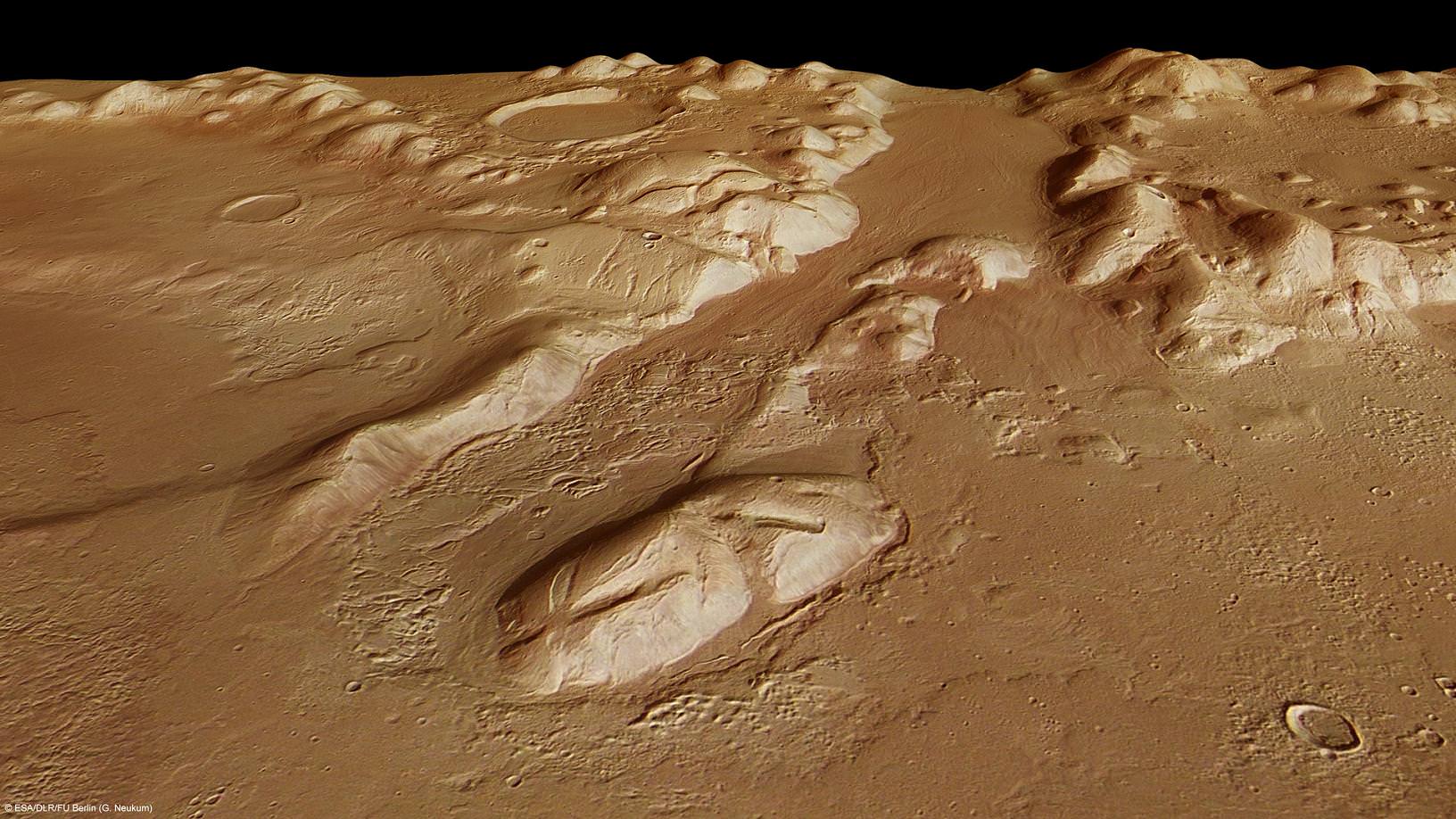
Phlegra Montes is a range of gently curving mountains and ridges on Mars. They extend from the northeastern portion of the Elysium volcanic province to the northern lowlands. The High-Resolution Stereo Camera on ESA’s Mars Express collected the data for these images on 1 June 2011 during orbit 9465. This perspective view has been calculated from the Digital Terrain Model derived from the stereo channels. Credits: ESA/DLR/FU Berlin (G. Neukum)
[/caption]
When it comes to exploring Mars, one of the greatest needs future astronauts will face is water. Why? Simple enough. Transporting water would take a huge amount of fuel. Now the Mars Express has imaged an area on the red planet which may yield large quantities of sub-surface ice. Its name is Phlegra Montes…
Extending from the northeastern portion of the Elysium volcanic province to the northern lowlands, spanning latitudes from roughly 30°N to 50°N, the Phlegra Montes are a gently rolling series of hills that have been probed by radar. It is surmised these low mountain ranges are not volcanic in origin, but created through tectonic forces and may conceal a copious supply of frozen water.
Thanks to high resolution stereo imaging from ESA’s Mars Express orbiter, we’re able to detect a feature called ‘lobate debris aprons’. They appear to surround almost every mountain in the Phelegra’s and it’s a normal feature for mountains found around these latitudes. Earlier studies of the debris aprons show the material has slid down the mountain slopes with time – a feature shared with Earth’s glaciers. Because of this similarity, scientists surmise this region may be a type of Martian glacier. It’s a guess that’s also been confirmed by radar on NASA’s Mars Reconnaissance Orbiter.
Phlegra Montes is a range of gently curving mountains and ridges on Mars. Flow patterns attributable to water are widely visible across the image. Linear flow patterns can be seen inside the valley (Box 1). Nearly every mountain is surrounded by an apron of rocky debris (Box 2). Over time, this debris appears to have moved down the mountainside and looks similar to the debris found covering glaciers here on Earth. Lobe-shaped structures seen inside impact craters in the region (Box 3) are known as concentric crater fill and are perhaps another indication of subsurface water ice. The High-Resolution Stereo Camera on ESA’s Mars Express collected the data for these images on 1 June 2011 during orbit 9465. Credits: ESA/DLR/FU Berlin (G. Neukum)
According to the radar data, the lobate debris aprons could indeed signal the presence of ice – perhaps only 20 meters below the surface. To further confirm their findings, nearby impact craters also show signs of recent glaciation. It would appear that ridges formed inside these ancient holes from snowfall, and then slid down the slopes. With time, it compacted to form a glacier structure… and even more glacier flow patterns are visible in the valleys.
How did this come to be? A one time, Mars’ polar axis was quite different than it is today. As it changed, it created different climatic conditions and mid-latitude glaciers may have developed at different times over the last several hundred million years. While you might be tired of hearing about water on Mars, the findings are very exciting for the future of exploration. It means the door is open…