Perseverance is Turning Into That Friend That's Always Picking Up Rocks

This image shows the rock core from “Berea” inside inside the drill of NASA’s Perseverance Mars rover. Credit: NASA/JPL-Caltech/ASU/MSSS

On Thursday, March 30th, NASA’s Perseverance rover drilled and stored the first rock core sample of its newest science campaign. This is the sixteenth sample the rover has taken as part of the ambitious Mars Sample Return (MSR) mission, a collaborative effort between NASA and the European Space Agency (ESA) to retrieve Perseverance’s samples and bring them back to Earth. Once they arrive (expected to happen by 2033), scientists will analyze them using state-of-the-art machinery too heavy and cumbersome to send to Mars as part of a robotic mission.

Continue reading “Perseverance is Turning Into That Friend That's Always Picking Up Rocks”

Mars 2020’s New Name is… “Perseverance”

Artist's impression of the Perseverance rover on Mars. Credit: NASA-JPL

Sojourner, Spirit, Opportunity, Curiosity For decades, NASA’s robotic rovers have explored the surface of Mars looking for clues about its past and subsequent evolution. With every success and discovery, their names became part of the public discourse, infiltrating our vocabulary the same way iconic figures like Armstrong, Einstein, and Hubble did. But what of the next rover that will be sent to explore Mars this summer?

NASA has serious plans for the Mars 2020 rover, the next installment in the Mars Exploration Program after its sister-rover Curiosity. But before this mission can launch and add its impressive capabilities to the hunt for life on Mars (past and present), it needed a proper name. Thanks to Alexander Mather (a grade 7 student from Burke, Virginia), it now has one. From this day forward, the Mars 2020 rover will be known as the Perseverance rover!

Continue reading “Mars 2020’s New Name is… “Perseverance””

Pictures from Curiosity Show the Bottom of an Ancient Lake on Mars, the Perfect Place to Search for Evidence of Past Life

A view from the "Kimberley" formation on Mars taken by NASA's Curiosity rover. The strata in the foreground dip towards the base of Mount Sharp, indicating flow of water toward a basin that existed before the larger bulk of the mountain formed. This image was taken by the Mast Camera (Mastcam) on Curiosity on Sol 580 of the mission and has been “white balanced” to adjust for the lighting on Mars make the sky appear light blue. Credits: NASA/JPL-Caltech/MSSS

It’s all about the detail.

In a way, Mars looks like a dusty, dead, dry, boring planet. But science says otherwise. Science says that Mars used to be wet and warm, with an atmosphere. And science says that it was wet and warm for billions of years, easily long enough for life to appear and develop.

But we still don’t know for sure if any life did happen there.

Continue reading “Pictures from Curiosity Show the Bottom of an Ancient Lake on Mars, the Perfect Place to Search for Evidence of Past Life”

Engineers Develop a Whole New Way to Use Curiosity’s Drill After a Recent Hardware Failure

NASA's Curiosity Mars rover used a new drill method to produce a hole on February 26 in a target named Lake Orcadie. The hole marks the first operation of the rover's drill since a motor problem began acting up more than a year ago. Credit: NASA/JPL-Caltech/MSSS

Since it landed on Mars in 2012, the Curiosity rover has used its drill to gather samples from a total of 15 sites. These samples are then deposited into two of Curiosity’s laboratory instruments – the Sample Analysis at Mars (SAM) or the Chemistry and Mineralogy X-ray Diffraction (CheMin) instrument – where they are examined to tell us more about the Red Planet’s history and evolution.

Unfortunately, in December of 2016, a key part of the drill stopped working when a faulty motor prevented the bit from extending and retracting between its two stabilizers. After managing to get the bit to extend after months of work, the Curiosity team has developed a new method for drilling that does not require stabilizers. The new method was recently tested and has been proven to be effective.

The new method involves freehand drilling, where the drill bit remains extended and the entire arm is used to push the drill forward. While this is happening, the rover’s force sensor – which was originally included to stop the rover’s arm if it received a high-force jolt – is used to takes measurements. This prevents the drill bit from drifting sideways and getting stuck in rock, as well as providing the rover with a sense of touch.

NASA’s Curiosity rover raised robotic arm with drill pointed skyward while exploring Vera Rubin Ridge at the base of Mount Sharp inside Gale Crater – backdropped by distant crater rim. Credit: NASA/JPL/Ken Kremer/kenkremer.com/Marco Di Lorenzo

The test drill took place at a site called Lake Orcadie, which is located in the upper Vera Rubin Ridge – where Curiosity is currently located. The resulting hole, which was about 1 cm (half an inch) deep was not enough to produce a scientific sample, but indicated that the new method worked. Compared to the previous method, which was like a drill press, the new method is far more freehand.

As Steven Lee, the deputy project manager of the Mars Science Laboratory at NASA’s Jet Propulsion Laboratory, explained:

“We’re now drilling on Mars more like the way you do at home. Humans are pretty good at re-centering the drill, almost without thinking about it. Programming Curiosity to do this by itself was challenging — especially when it wasn’t designed to do that.”

This new method was the result of months of hard work by JPL engineers, who practiced the technique using their testbed – a near-exact replica of Curiosity. But as Doug Klein of JPL, one of Curiosity’s sampling engineers, indicated, “This is a really good sign for the new drilling method. Next, we have to drill a full-depth hole and demonstrate our new techniques for delivering the sample to Curiosity’s two onboard labs.”

This side-by-side comparison shows the X-ray diffraction patterns of two different samples collected from the Martian surface by NASA’s Curiosity rover, as obtained by Curiosity’s Chemistry and Mineralogy instrument (CheMin). Credit: NASA/JPL-Caltech/Ames

Of course, there are some drawbacks to this new method. For one, leaving the drill in its extended position means that it no longer has access to the device that sieves and portions rock powder before delivering it to the rover’s Collection and Handling for In-Situ Martian Rock Analysis (CHIMRA) instrumet. To address this, the engineers at JPL had to invent a new way to deposit the powder without this device.

Here too, the engineers at JPL tested the method here on Earth. It consists of the drill shaking out the grains from its bit in order to deposit the sand directly in the CHIMRA instrument. While the tests have been successful here on Earth, it remains to be seen if this will work on Mars. Given that both atmospheric conditions and gravity are very different on the Red Planet, it remains to be seen if this will work there.

This drill test was the first of many that are planned. And while this first test didn’t produce a full sample, Curiosity’s science team is confident that this is a positive step towards the resumption of regular drilling. If the method proves effective, the team hopes to collect multiple samples from Vera Rubin Ridge, especially from the upper side. This area contains both gray and red rocks, the latter of which are rich in minerals that form in the presence of water.

Samples drilled from these rocks are expected to shed light on the origin of the ridge and its interaction with water. In the days ahead, Curiosity’s engineers will evaluate the results and likely attempt another drill test nearby. If enough sample is collected, they will use the rover’s Mastcam to attempt to portion the sample out and determine how much powder can be shaken from the drill bit.

Further Reading: NASA

Mountains, Gandalf! Red Planet Pictures Show Mars In The Eyes Of The Rovers

An image of distant mountains taken by Curiosity's navcam on July 11, 2014, Sol 685 of the mission. The rover is in Gale Crater (near the equator of Mars) making a trek to Mount Sharp (the unofficial name for Aeolis Mons). Credit: NASA/JPL-Caltech

Fancy a little Mars in your daily life? You need go no further than the excellent raw image archive that NASA generously provides on its website, showing the view from the Opportunity and Curiosity rovers as they make their way on the surface.

Opportunity is rolling along in its eleventh year of operations, busily exploring the west rim of Endeavour Crater. Below the jump is a stunning stitch-together of some of its latest images from space tweep Stu Atkinson, who runs a lovely blog called Road to Endeavour about the rover’s adventures. NASA also has an official blog that was last updated July 1.

The Curiosity rover is in Gale Crater near the Martian equator, heading towards Mount Sharp as NASA picks paths that are the softest for its damaged wheels. Panorama maker Andrew Bodrov recently put together a new 360-degree view of Curiosity’s mastcam, which encompasses 137 images taken on Sol 673. You can see that below the jump as well.

Panorama based on pictures taken by the Opportunity rover in July 2014. Credit: Panorama by Stu Atkinson, photos by NASA/JPL-Caltech/Cornell Univ./Arizona State Univ


Mars Panorama – Curiosity rover: Martian solar day 673 in out-of-this-world

Below are a couple of more raw views from the Curiosity rover taken on Sol 685.

A view of one of Curiosity's wheels taken by the rover's navcam on July 11, 2014 (Sol 685). Credit: NASA/JPL-Caltech
A view of one of Curiosity’s wheels taken by the rover’s navcam on July 11, 2014 (Sol 685). Credit: NASA/JPL-Caltech

Martian dunes dominate the scene in this picture taken by the Curiosity rover's navcam on July 11, 2014 (Sol 685). The rover is in Gale Crater, an equatorial region, on its way to Aeolis Mons (Mount Sharp). Credit: NASA/JPL-Caltech
Martian dunes dominate the scene in this picture taken by the Curiosity rover’s navcam on July 11, 2014 (Sol 685). The rover is in Gale Crater, an equatorial region, on its way to Aeolis Mons (Mount Sharp). Credit: NASA/JPL-Caltech

And across Mars, some views from Opportunity on Sol 3721 of the mission. The rover is facing the elimination of its funding in 2015, although in budget discussions from February NASA said it does have a route for it to get money (if Congress approves).

A view from NASA's Curiosity rover on Sol 3721 as it explores Endeavour Crater. Credit: NASA/JPL-Caltech/Cornell Univ./Arizona State Univ.
A view from NASA’s Opportunity rover on Sol 3721 as it explores Endeavour Crater. Credit: NASA/JPL-Caltech/Cornell Univ./Arizona State Univ.

A view from NASA's Curiosity rover on Sol 3721 as it explores Endeavour Crater. Credit: NASA/JPL-Caltech/Cornell Univ./Arizona State Univ.
A view from NASA’s Opportunity rover on Sol 3721 as it explores Endeavour Crater. Credit: NASA/JPL-Caltech/Cornell Univ./Arizona State Univ.

A view from NASA's Opportunity rover on Sol 3721 as it explores Endeavour Crater. Credit: NASA/JPL-Caltech/Cornell Univ./Arizona State Univ.
A view from NASA’s Opportunity rover on Sol 3721 as it explores Endeavour Crater. Credit: NASA/JPL-Caltech/Cornell Univ./Arizona State Univ.

Go Mars-Digging Beside Curiosity In New Interactive Panorama

A still from a Mars Curiosity panorama stitched together from NASA images. Credit: Andrew Bodrov, from NASA/JPL-Caltech/MSSS images

Here’s a nice distraction to start off the day: pretend you’re playing in the sandbox of Mars alongside Curiosity. This new panorama shows the NASA Rover hanging out somewhat nearby Mount Sharp (Aeolis Mons), its ultimate destination for the two-year prime mission it’s currently on.

“The images for panorama [were] obtained by the rover’s 34-millimeter Mast Camera,” wrote Andrew Bodrov on a blog post describing his work. “The mosaic, which stretches about 30,000 pixels’ width, includes 101 images taken on Sol 437.”

Bodrov, who is from Estonia, frequently does space-related panoramas. We wrote about a couple of other Curiosity panoramas he did in March 2013, in February 2013 and August 2012.

Last year, he told Universe Today that he has used PTGui panoramic stitching software from New House Internet Services BV to accomplish the stunning views.

He also has a wealth of images from the Baikonur Cosmodrome, which is the launch site for Soyuz spacecraft missions.

“It’s very nice to see the achievements of humanity which allows you to see a picture of another world,” Bodrov said in 2012.

Finding Life in All the Unlikely, Unexpected Places

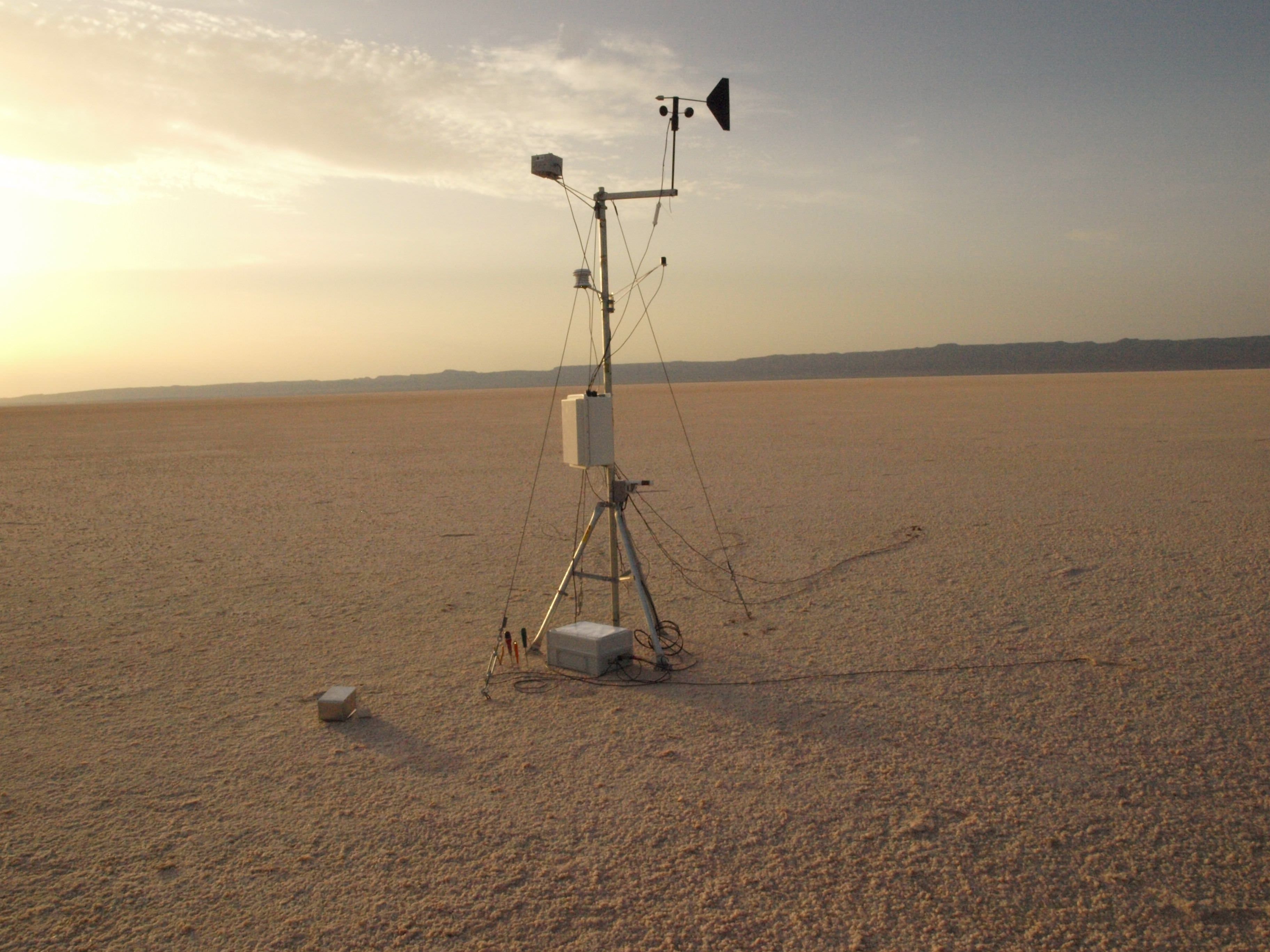
Just one of several weather stations set up at Chott El Jerid, a Tunisian saltpan, measuring temperature, humidity, ultraviolet radiation, wind direction and velocity. Image credit: Felipe Goméz/Europlanet

From orbit and on the ground, Mars looks inhospitable. But it doesn’t look much different than the freezing Antarctic plains, sun-baked saltpans in Tunisia or Spain’s corrosively acidic Rio Tinto, according to a few explorers from the Centro de Astrobiología (CAB) in Madrid, who today presented some of their findings of life during a press conference at the European Planetary Science Congress.

The biggest difference, however, is that life still thrives in these extreme locales on Earth.

“The big questions are: what is life, how can we define it and what the requirements for supporting life?” asks project leader Dr. Felipe Goméz. “To understand the results we receive back from missions like Curiosity, we need to have detailed knowledge of similar environments on Earth. Metabolic diversity on Earth is huge. We have found a range of complex chemical processes that allow life to survive in unexpected places.”

Over the past four years, Goméz and his colleagues have checked Earth’s most inhospitable locales; the Chott el Jerid saltpan in Tunisia, the Atacama Desert in Chile, Rio Tinto in southern Spain and Deception Island in Antarctica.

While visiting Chott el Jerid, the team tracked huge changes in environmental conditions throughout the day but it was a small rise in surface temperature after dusk that caught their eye. “We found that this is caused by water condensing on the surface and hydrating salts which releases heat in an exothermic reaction,” he said in the press release. This is very interesting from the perspective of the REMS instrument on Curiosity — it gives us away to follow when liquid water might be present on the surface.”

The team also built a three-dimensional picture of the subsurface in the saltpan by measuring the electrical properties of the soil. While drilling several meters into the subsurface at Chott el Jerid and in the Atacama Desert, researchers found bacteria at depth that was completely isolated from the surface. The researchers found not only bacteria, but also single-celled halophilic organisms that are able to oxidize metabolites under both aerobic and anaerobic conditions.

Along the surface of Chott El Jerid, which is made up of very pure sodium chloride with a trace of other salts, the team found small pieces of organic matter within the salt crystals. Once analyzed, they found populations of halophilic, salt-loving, dormant bacteria. In the laboratory, they were able to rehydrate the samples and bring the bacteria back to life, Goméz said.

Another unexpected find occurred while studying outcrops of the mineral jarosite at Rio Tinto in Spain. Jarosite, found on the surface of Mars by the Mars Exploration Rover Opportunity, forms only in the presence of water that contains high concentrations of metals, such as iron. The outcrops at Rio Tinto also are extremely corrosive. Yet, sandwiched between layers in the salt crusts, the team found photosynthetic bacteria. Unexpectedly, iron in the salt crust seems to protect bacteria from ultraviolet radiation, Goméz said. Samples of bacteria with iron present were exposed with high levels of ultraviolet radiation. They survived while bacteria samples without iron were destroyed.

“What the bacteria we found in Rio Tinto show is that the presence of ferric compounds can actually protect life. This could mean that life formed earlier on Earth than we thought. These effects are also relevant for the formation of life on the surface of Mars,” says Goméz. The team also found that salt provides stable conditions that can allow life to survive in very hard environments.

“Within salts, the temperature and humidity are protected from fluctuations and the doses of ultraviolet radiation are very low,” explained Goméz. “In the laboratory, we placed populations of different bacteria between layers of salt a few millimetres thick and exposed them to Martian conditions. Nearly 100% of deinoccocus radiodurans, a hardy type of bacteria survived being irradiated. But fascinatingly, about 40% of acidithiobacillus ferrooxidans – a very fragile variety of bacteria – also survived when protected by a salt crust.”

The findings have implications not only for studying possible life on Mars, but also for the development of life on early Earth.

Source: European Planetary Science Congress (EPSC) 2012 Press Release

Image Details: Photosynthetic bacteria at Rio Tinto. Credit: Felipe Goméz

About the author: John Williams is owner of TerraZoom, a Colorado-based web development shop specializing in web mapping and online image zooms. He also writes the award-winning blog, StarryCritters, an interactive site devoted to looking at images from NASA’s Great Observatories and other sources in a different way. A former contributing editor for Final Frontier, his work has appeared in the Planetary Society Blog, Air & Space Smithsonian, Astronomy, Earth, MX Developer’s Journal, The Kansas City Star and many other newspapers and magazines. Follow John on Twitter @terrazoom

Say Ahhh to Mars

Take a deep breath because this new panorama from Mars enthusiast Stu Atkinson will take it away.

“Anyway, a whole bunch of these came down, like I said, and to my delight they all linked up to form a big, biiiiiiiig panoramic mosaic,” said Stu on his blog “The Gale Gazette.” “And here it is. Obviously you’ll need to click on it to enlarge it… and I’ll warn you, it’s a big image, you can kiss the next few minutes goodbye because you’ll be panning around it for a while…”

Zoom in and you can see actual rocks. Click that little button at the right of the toolbar and Mars will take over your screen.

So far, Curiosity has rolled across a barely dusty plain in Gale Crater. Here’s a look of things to come. In black-and-white image from Curiosity, there appear to be big dunes to cross to get to the foothills of Aeolis Mons, or Mount Sharp.

A black-and-white but still breathtaking view of the dusty terrain between Curiosity’s current location and the foothills of Aeolis Mons, or Mount Sharp. Credit: NASA/JPL/Stu Atkinson

Curiosity has nearly finished robotic arm tests. Once complete, the rover will be able to touch and examine its first Mars rock.

“We’re about to drive some more and try to find the right rock to begin doing contact science with the arm,” said Jennifer Trosper, Curiosity mission manager at NASA’s Jet Propulsion Laboratory in Pasadena, Calif, in a press release.

This image from NASA’s Curiosity rover shows the open inlet where powered rock and soil samples will be funneled down for analysis. It was taken by the Mars Hand Lens Imager (MAHLI) on Curiosity’s 36th Martian day, or sol, of operations on Mars (Sept. 11, 2012). MAHLI was about 8 inches (20 centimeters) away from the mouth of the Chemistry and Mineralogy (CheMin) instrument when it took the picture. The entrance of the funnel is about 1.4 inches (3.5 centimeters) in diameter. The mesh screen is about 2.3 inches (5.9 centimeters) deep. The mesh size is 0.04 inches (1 millimeter). Once the samples have gone down the funnel, CheMin will be shooting X-rays at the samples to identify and quantify the minerals.

Engineers and scientists use images like these to check out Curiosity’s instruments. This image is a composite of eight MAHLI pictures acquired at different focus positions and merged onboard the instrument before transmission to Earth; this is the first time the MAHLI performed this technique since arriving at Curiosity’s field site inside Gale Crater. The image also shows angular and rounded pebbles and sand that were deposited on the rover deck during landing on Aug. 5, 2012 PDT (Aug. 6, 2012 EDT).

Two science instruments, a camera called Mars Hand Lens Imager, or MAHLI, that can take close-up color images and a tool called Alpha Particle X-ray Spectrometer (APXS) that can determine the elemental composition of a rock, also have passed tests. The instruments are mounted on a turret at the end of the robotic arm and can be placed in contact with target rocks. The adjustable focus MAHLI camera produced images this week of objects near and far; of the underbelly of Curiosity, across inlet ports and a penny that serves as a calibration target on the rover.

This close-up image shows tiny grains of Martian sand that settled on the penny that serves as a calibration target on NASA’s Curiosity rover. The larger grain under Abraham Lincoln’s ear is about 0.2 millimeters across. The grains are classified as fine to very fine sand.

The Mars Hand Lens Imagery (MAHLI) on the Curiosity rover taken by the Mast Camera on the 32nd Martian day, or sol, of operations on the surface. Engineers imaged MAHLI to inspect the dust cover and to ensure that the tool’s LED lights are functional. Scientists enhanced the image to show the scene as it would appear under Earth’s lighting conditions. This helps in analyzing the background terrain.

Check out more images from the Mars Science Laboratory teleconference.

Image credit: NASA/JPL-Caltech/MSSS

Take a Trip to Explore Gale Crater

Mount Sharp Compared to Three Big Mountains on Earth

Images from the Curiosity rover on Mars are truly spectacular but a large mosaic from the THEMIS camera aboard NASA’s Mars Odyssey orbiter gives a grand perspective of our new foothold on Mars. Take some time to rove and explore Gale Crater.

The viewer, created using a web-imaging technology from Zoomify, is set to move between points of interest, such as Mars Science Laboratory’s landing site in Aeolis Palus, Glenelg, and Aeolis Mons/Mount Sharp itself. The layered sediments flanking Mount Sharp make it the primary target for Curiosity’s two-year mission. Take control at anytime by clicking on the image. This will stop the automatic roving and leave you in control to explore the terrain of Gale Crater. Use your mouse or the toolbar controls to pan and zoom around the image. You can also use the dropdown in the upper right to take you directly to certain points of interest in the image. Over time, we will add to this interactive feature as more geological points of interest are identified.

THEMIS stands for Thermal Emission Imaging System which is a multiband visible and infrared camera aboard Odyssey. The comprehensive mosaic is pieced together from 205 individual scenes, most taken recently but some dating to 2002 shortly after Odyssey entered Mars orbit in 2001. These images were taken before MSL landed on Mars. Even so, as large as the SUV-sized rover is, it would be too small to see in these images. The smallest details in this image are 18 meters or 60 feet across.

This illustration shows the size of Aoelis Mons (Mount Sharp) in comparison to three large mountains on Earth. The elevation of Mount Sharp is given in kilometers above the floor of Gale Crater. The heights of the Earth mountains are given in kilometers above sea level. Image credit: Tanya Harrison, NASA/JPL-Caltech/MSSS

Gale Crater is 154 kilometers (96 miles) wide. Near the center rises Aeolis Mons, a 5 km (3 mile) high mound of layered sediments, informally dubbed Mount Sharp, after planetary geologist Robert Sharp who died in 2004. Scientists for a time referred to the conical mountain as “The Mound.” The mountain, which would stand among the highest on Earth, cannot be seen from Earth and was unknown before planetary probes visited the Red Planet.

“The reason we decided to assemble such a large, comprehensive mosaic of Gale Crater was to give ourselves a better sense of the context around the landing site, said Jonathon Hill, a Mars research at Arizona State University who assembled the mosaic, a press release. “This will help us to better understand what Curiosity sees and measures as it roves the surface.”

Gale Crater zoom tour created by John Williams (TerraZoom) using Zoomify.

About the author: John Williams is owner of TerraZoom, a Colorado-based web development shop specializing in web mapping and online image zooms. He also writes the award-winning blog, StarryCritters, an interactive site devoted to looking at images from NASA’s Great Observatories and other sources in a different way. A former contributing editor for Final Frontier, his work has appeared in the Planetary Society Blog, Air & Space Smithsonian, Astronomy, Earth, MX Developer’s Journal, The Kansas City Star and many other newspapers and magazines.

President Obama Calls with Congratulations for Mars Science Laboratory Team

US President Barack Obama called up the Mars Science Laboratory team at the Jet Propulsion Laboratory today, August 13, congratulating them on the perfect landing of the Curiosity rover one week ago today.

“What you did on Mars was incredibly impressive,” the President said, “with those 76 pyrotechnics going on in perfect succession, the 500,000 lines of code working exactly the way you guys had ordered them, it’s really mind boggling what you’ve been able to accomplish. Being able to get that whole landing sequence to work the way you did, it’s a testimony to your team.”

Obama specifically congratulated Charles Elachi, the head of JPL, the entry, descent and landing lead, Adam Steltzner for the audacious Sky Crane system.

“What you accomplished embodied the American spirit and your passion and your commitment is making a difference and your hard work is now paying dividends, because our expectation is that Curiosity is going to be telling us things that we did not know before and laying the groundwork for an even more audacious undertaking in the future, and that’s a human mission to the Red Planet.”

Obama joked about letting him know right away if they find any Martians, and perhaps getting a Mohawk, just like Bobak Ferdowsi, a systems engineer in JPL’s mission control who became an unexpected “star of the show” on Sunday night’s webcast, for his American flag-themed stars and stripes Mohawk haircut.

“That’s going to be the new fashion at JPL,” Elachi replied.

“It does sound like NASA’s come a long way from the white shirts, black-rimmed glasses and the pocket protectors,” the President joked. “You guys are a little cooler than you used to be.”

Obama said his administration is putting a big focus on improving science, technology, engineering and math education; however, NASA and other science arms of the government are all facing massive cuts. Perhaps MSL has captured the President’s attention enough to, maybe, change his focus. Several people have sent messages to Obama via Twitter, such as this one:

A view of the crowd gathered at Times Square in New York City to watch the landing of Curiosity on Mars. Credit: @CSMuncyPhoto

Then Obama said, “I’m going to give you guys a personal commitment to protect these critical investments in science and technology, I thank you for devoting your lives to this cause and if, in fact, you do make contact with Martians, please let me know right away. I’ve got a lot of other things on my plate, but I suspect that that will go to the top of the list. Even if they’re just microbes, it will be pretty exciting.”

Obama said the incredible landing of Curiosity is the kind of thing that inspires kids across the country. “They are telling their moms and dads they want to be part of a Mars mission, maby even the first person to walk on Mars. That kind of inspiration is a by-product of the work that you have done.”

“You guys have done an outstanding job, you’ve made us all proud… you are examples of American know-how and ingenuity and we can’t wait to start hearing back from Curiosity and finding on what is going on.”