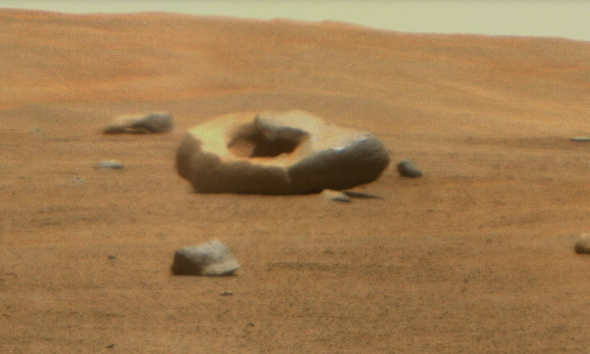
NASA's Perseverance rover spotted a donut-shaped rock on Mars. Credit: NASA/JPL-Caltech
The pareidolia crowd is sure to have a field day with this! Once again, an oddly-shaped rock has been spotted on Mars. Once again, the rock is donut-shaped. This particular rock was spotted by NASA’s Perseverancerover, which continues to explore the Jezero Crater in Mars’ northern hemisphere. The image was taken by the Remote Microscopic Imager (RMI), part of the SuperCam instrument, at a distance of about 100 meters (328 feet) from the rover, on June 22nd, 2023 – the 832nd Martian day (or sol) of the mission.
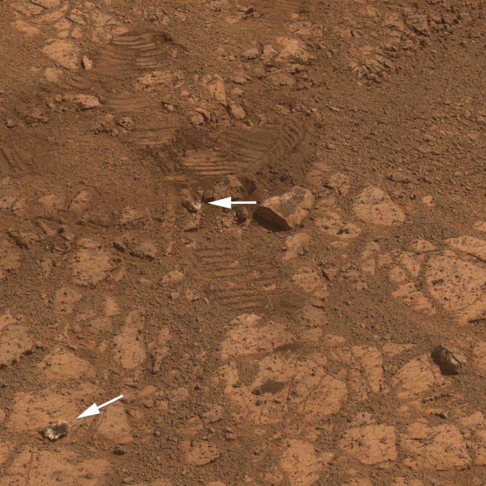
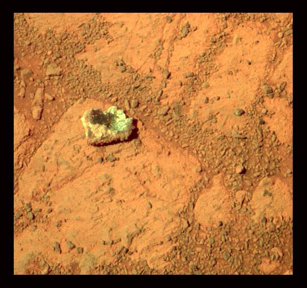
This image from the panoramic camera (Pancam) on NASA’s rover Opportunity shows the location of a rock called "Pinnacle Island" before it appeared in front of the rover in early January 2014. Arrow at lower left. This image was taken during Sol 3567 of Opportunity's work on Mars (Feb. 4, 2014). Credit: NASA/JPL-Caltech/Cornell Univ./Arizona State Univ.
The mystery of the world famous “Jelly Doughnut” rock on Mars has at last been solved by diligent mission scientists toiling away in dank research labs on Earth.
The “Jelly Doughnut” rock achieved worldwide fame, or better yet infamy, when it suddenly appeared out of nowhere in pictures taken by NASA’s renowned Red Planet rover Opportunity in January.
And the answer is – well it’s not heretofore undetected Martian beings or even rocks falling from the sky.
Rather its ‘Alien Space Invaders’ – in some sense at least.
And that ‘Alien Space Invader’ is from – Earth! And her name is – Opportunity!
Indeed sister rover Curiosity may have unwittingly pointed to the culprit and helped resolve the riddle when she snapped a brand new photo of Earth – home planet to Opportunity and Curiosity and all their makers! See the evidence for yourselves – lurking here!
It turns out that the six wheeled Opportunity unknowingly ‘created’ the mystery herself when she drove over a larger rock, crushing it with the force from the wheels and her 400 pound (185 kg) mass.
Fragments were sent hurtling across the summit of the north facing Solander Point mountain top, where she is currently climbing up ‘Murray Ridge’ along the western rim of a vast crater named Endeavour that spans some 22 kilometers (14 miles) in diameter. See traverse map below.
One piece unwittingly rolled downhill.
That rock fragment – now dubbed ‘Pinnacle Island’ – suddenly appeared in pictures taken by Opportunity’s cameras on Jan, 8, 2014 (Sol 3540).
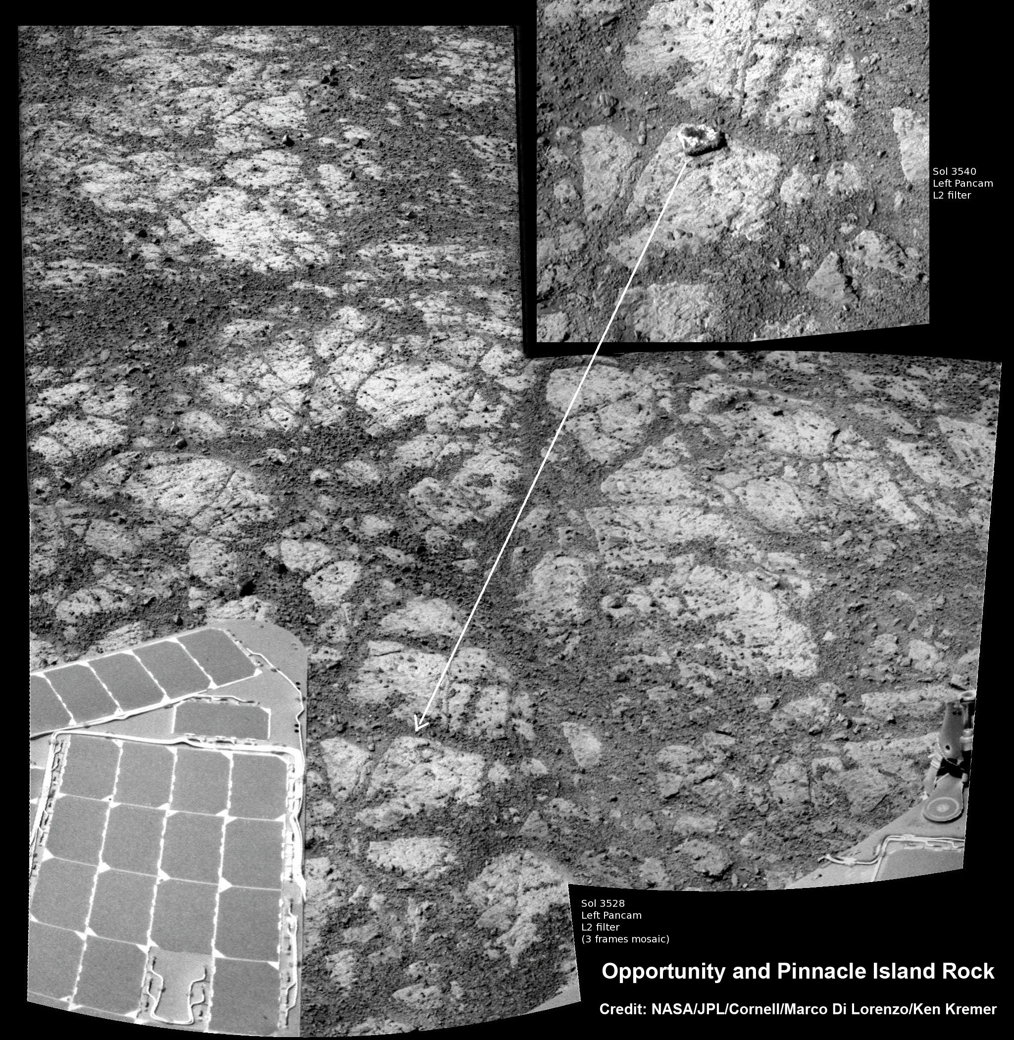
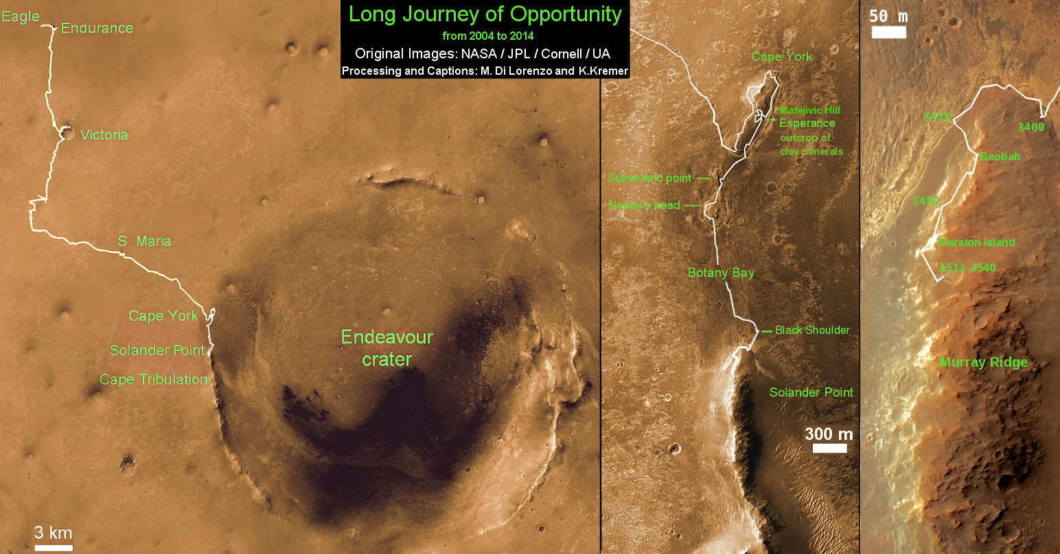
Mosaic of Opportunity and mysterious Pinnacle Island rock by Solander Point peak. Mysterious Pinnacle Island rock suddenly appeared out of nowhere in images snapped on Sol 3540. It was absent in earlier images on Sol 3528. This mosaic shows the rock nearby the solar panels of NASA’s Opportunity rover. Assembled from Sol 3528 and 3540 pancam raw images. Credit: NASA/JPL/Cornell/Marco Di Lorenzo/Ken Kremer-kenkremer.com
And that exact same spot had been vacant of debris in photos taken barely 4 days earlier – during which time the rover didn’t move a single millimeter.
Pinnacle Island measures only about 1.5 inches wide (4 centimeters) with a noticeable white rim and red center – hence its jelly doughnut nickname.
The Martian riddle was finally resolved when Opportunity roved a tiny stretch and took some look back photographs to document the ‘mysterious scene’ for further scrutiny.
“Once we moved Opportunity a short distance, after inspecting Pinnacle Island, we could see directly uphill an overturned rock that has the same unusual appearance,” said Opportunity Deputy Principal Investigator Ray Arvidson of Washington University in St. Louis, in a NASA statement.
“We drove over it. We can see the track. That’s where Pinnacle Island came from.”
New pictures showed another fragment of the rock – dubbed ‘Stuart Island’ – eerily similar in appearance to the ‘Pinnacle Island’ doughnut.
Opportunity by Solander Point peak – 2nd Mars Decade Starts here! NASA’s Opportunity rover captured this panoramic mosaic on Dec. 10, 2013 (Sol 3512) near the summit of “Solander Point” on the western rim of Endeavour Crater where she starts Decade 2 on the Red Planet. She is currently investigating outcrops of potential clay minerals formed in liquid water on her 1st mountain climbing adventure. Assembled from Sol 3512 navcam raw images. Credit: NASA/JPL/Cornell/Marco Di Lorenzo/Ken Kremer-kenkremer.com
To gather some up-close clues before driving away, the rover deployed its robotic arm to investigate ‘Pinnacle Island’ with her microscopic imager and APXS mineral mapping spectrometer.
The results revealed high levels of the elements manganese and sulfur “suggesting these water-soluble ingredients were concentrated in the rock by the action of water,” says NASA.
“This may have happened just beneath the surface relatively recently,” Arvidson noted, “or it may have happened deeper below ground longer ago and then, by serendipity, erosion stripped away material above it and made it accessible to our wheels.”
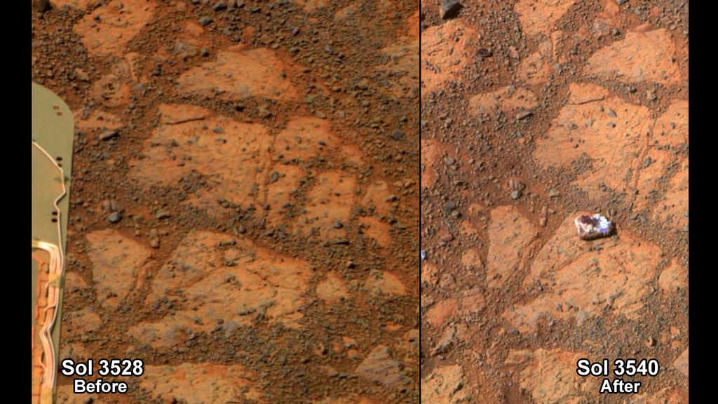
This before-and-after pair of images of the same patch of ground in front of NASA’s Mars Exploration Rover Opportunity 13 days apart documents the arrival of a bright rock onto the scene. Credit: NASA/JPL-Caltech/Cornell Univ./Arizona State Univ.
The Solander Point mountaintop is riven with outcrops of minerals, including clay minerals, that likely formed in flowing liquid neutral water conducive to life – potentially a scientific goldmine.
Opportunity is NASA’s 1st ever ‘Decade Old’ living Mars rover.
She has been uncovering and solving Mars’ billion years old secrets for over 10 years now since landing back on January 24, 2004 on Meridiani Planum – although she was only expected to function a mere 90 days!
Today, Feb 15, marks Opportunity’s 3578th Sol or Martian Day roving Mars.
So far she has snapped over 188,700 amazing images on the first overland expedition across the Red Planet.
Her total odometry stands at over 24.07 miles (38.73 kilometers) since touchdown on Jan. 24, 2004 at Meridiani Planum.
Meanwhile on the opposite side of Mars, Opportunity’s younger sister rover Curiosity is trekking towards gigantic Mount Sharp and just crested over the Dingo Gap sand dune. She celebrated 500 Sols on Mars on New Years Day 2014.
Finally, China’s Yutu rover has awoken for her 3rd workday on the Moon.
Stay tuned here for Ken’s continuing Opportunity, Curiosity, Chang’e-3, LADEE, MAVEN, Mars rover, MOM and continuing planetary and human spaceflight news.
Traverse Map for NASA’s Opportunity rover from 2004 to 2014
This map shows the entire path the rover has driven during a decade on Mars and over 3560 Sols, or Martian days, since landing inside Eagle Crater on Jan 24, 2004 to current location by Solander Point summit at the western rim of Endeavour Crater. Rover will spend 6th winter here atop Solander. Opportunity discovered clay minerals at Esperance – indicative of a habitable zone. Credit: NASA/JPL/Cornell/ASU/Marco Di Lorenzo/Ken Kremer – kenkremer.com
This before-and-after pair of images of the same patch of ground in front of NASA's Mars Exploration Rover Opportunity 13 days apart documents the arrival of a bright rock onto the scene. Credit: NASA/JPL-Caltech/Cornell Univ./Arizona State Univ.
Hoo boy. Just mention the word “mystery” in conjunction with the planet Mars and all sorts of folks come out of the woodwork. Some start talking about silicon-based alien life forms or Mars-based reptiles or projectiles being tossed by little green men. The latest is that there’s an exotic mushroom on Mars, and this idea has sparked a lawsuit against NASA.
This all started when a strange rock suddenly appeared in photos from the Opportunity rover in a spot where photos taken just 12 sols (Mars days) earlier showed no rock. Mission principal investigator Steve Squyres talked about it during the recent 10-year anniversary celebration for the rover.
“It appeared,” Squyres said during the event. “It just plain appeared and we haven’t driven over that spot.”
They’ve named the rock “Pinnacle Island,” and Squyres and the Mars Exploration Rover team think the most likely scenario is that the rover actually dislodged the rock with its wheels and flicked it to a new spot as the rover was turning. “We had driven a meter or two away from here and somehow maybe one of the wheels managed spit it out of the ground,” Squyres said. “That’s the more likely theory.”
A colorized version of the rock called Pinnacle Island. Credit: NASA/JPL, color by Stuart Atkinson.
Another idea is that the rock is a piece of ejecta – a piece of rock which plunked down near the rover after being blasted out of the ground by a nearby meteoroid impact.
An idea favored by our readers here on Universe Today is that it possibly was a meteorite, dropping in from space and landing near the rover. Another thought is that since Opportunity is currently at Solander Point, a mountain of sorts, the rock may have rolled down to its new spot from a higher outcrop.
We checked in with Steve Squyres to see if there any new possibilities and he said the team thoughts on the rock’s appearance are the same as they were last week.
“We think the most likely hypothesis is that it was dislodged by the rover wheels from a location that may currently be obscured by the solar arrays,” he said via email.
Squyres described the rock as “white around the outside, in the middle there’s low spot that is dark red. It looks like a jelly donut,” and said it’s like nothing they’ve ever seen before on Mars.
Then things got weird. We received an email this week from neurologist and self-proclaimed astrobiologist Dr. Rhawn Joseph, of the Journal of Cosmology fame who we’ve previously written about.
He has filed a lawsuit in the US District Court Northern District of California claiming the white rock is biological in nature and is seeking an order forcing NASA, Administrator Charles Bolden, and others including Squyres to “examine a biological specimen on Mars” and that NASA is failing to investigate the rock thoroughly enough.
Joseph is petitioning the Federal Court for a writ of mandamus to “compel and order” NASA to “perform a public, scientific, and statutory duty which is to closely photograph and thoroughly scientifically examine and investigate a putative biological organism which was identified (and thus discovered) by Petitioner.”
From the lawsuit:
“Petitioner immediately recognized that bowl-shaped structure, hereafter referred to as Sol 3540,resembling a mushroom-like fungus, a composite organism consisting of colonies of lichen and cyanobacteria, and which on Earth is known as Apothecium.”
“When examined by Petitioner the same structure in miniature was clearly visible upon magnification and appears to have just germinated from spores.”
For one thing, this is a rock. A rock. Squyres has said Pinnacle Island is very high in sulfur and magnesium, with twice as much manganese as anything else they’ve seen on Mars.
Second, the rover team is already throwing everything they’ve got at this rock.
“We are as we speak situated with the rover, with its instruments, making measurements on this rock. We’ve taken pictures of both the donut part and the jelly part,” Squyres said during the 10-year anniversary event.
Third, Joseph is not the “discoverer” of this rock. The MER team is and they’ve given full disclosure, talking frequently about the rock and posting all the images they’ve taken of the rock available for anyone to peruse.
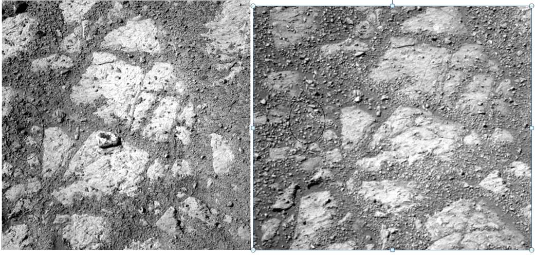
They’ve offered a few ideas, but this image from sol 3544 pointed out by “marsophile” on the forum might be the most compelling:
A disturbed area near the Opportunity rover that could be the spot where ‘Pinnacle Island’ came from. Credit: NASA/JPL.
There appears to hole in the ground where a rock may have previously been.
Another set of images submitted by Universe Today reader Yuksel Kenaroglu highlights a possible location where the rock may have come from, but changes in lighting might just be making things look different in the two images:
Two images from the Opportunity rover from Sol 3528 (right) and Sol 3540 showing possible location of where the ‘Jelly Donut’ rock came from. Image credit: Credit: NASA/JPL-Caltech/Cornell Univ./Arizona State Univ., notation via Yuksel Kenaroglu.
Joseph said he wants “A) 100 high resolution close-up infocus photos of the specimen identified in Sol 3540, at various angles, from all sides, and from above down into the “bowl” of the specimen, and under appropriate lighting conditions which minimize glare. B) Take a minimum of 24 microscopic in-focus images of the exterior, lip, walls, and interior of the specimen under appropriate lighting conditions. C) NASA, and the rover team must make public and supply Petitioner with all high resolution photos and images of that specimen as demanded in A and B.”
Surely, Squyres and the MER team would like nothing better than to solve the mystery of how this rock appeared and just like the Mars flower, and the piece of plastic there’s very little likelihood that biology plays any role in this rock an how it suddenly appeared.