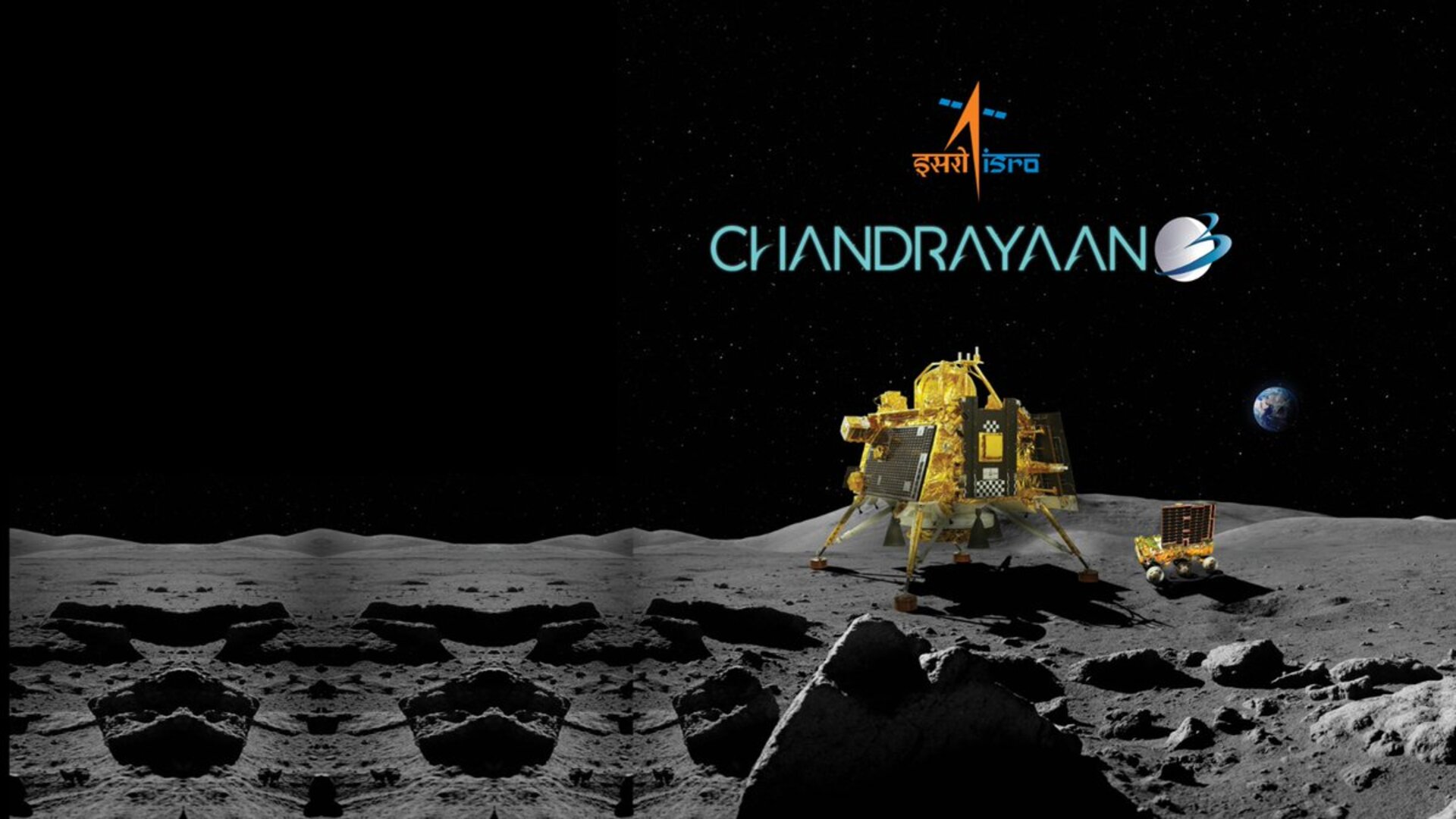
The Indian Space Research Organisation (ISRO) successfully landed its Chandrayaan-3 Lander Module on the surface of the Moon on August 23, 2023. Credit: ISRO
On July 14th, 2023, the Indian Space Research Organization (ISRO) launched the third mission in its Chandrayaan (“Moon vehicle” in Hindi) lunar exploration program. Earlier this week (Wednesday, August 23rd), the Chandrayaan-3 mission’s Vikram lander touched down on the far side of the Moon, making India the fourth nation in the world to send missions to the lunar surface and the first to land one near the Moon’s south pole region. Shortly after that, the ISRO announced that they had deployed Pragyan, the rover element of the mission, to the surface.
The Indian Space Research Organisation (ISRO) successfully landed its Chandrayaan-3 Lander Module on the surface of the Moon on August 23, 2023. Credit: ISRO
India’s space agency successfully landed their Chandrayaan-3 lander on the lunar surface, becoming the fourth country to touch down on the Moon and the first to land at one of the lunar poles.
The Indian Space Resource Organization’s (ISRO) Chandrayaan-3 launched last month and made a soft landing on the Moon’s south pole at approximately 8:34 a.m. ET on August 23. The mission is set to begin exploring an area of the Moon that is of extreme interest, but Chandrayaan-3 is the first to visit this area in-situ. The lunar south pole is thought to contain water ice that could be a source of oxygen, fuel, and water for future missions, or perhaps even for a future lunar base or colony.
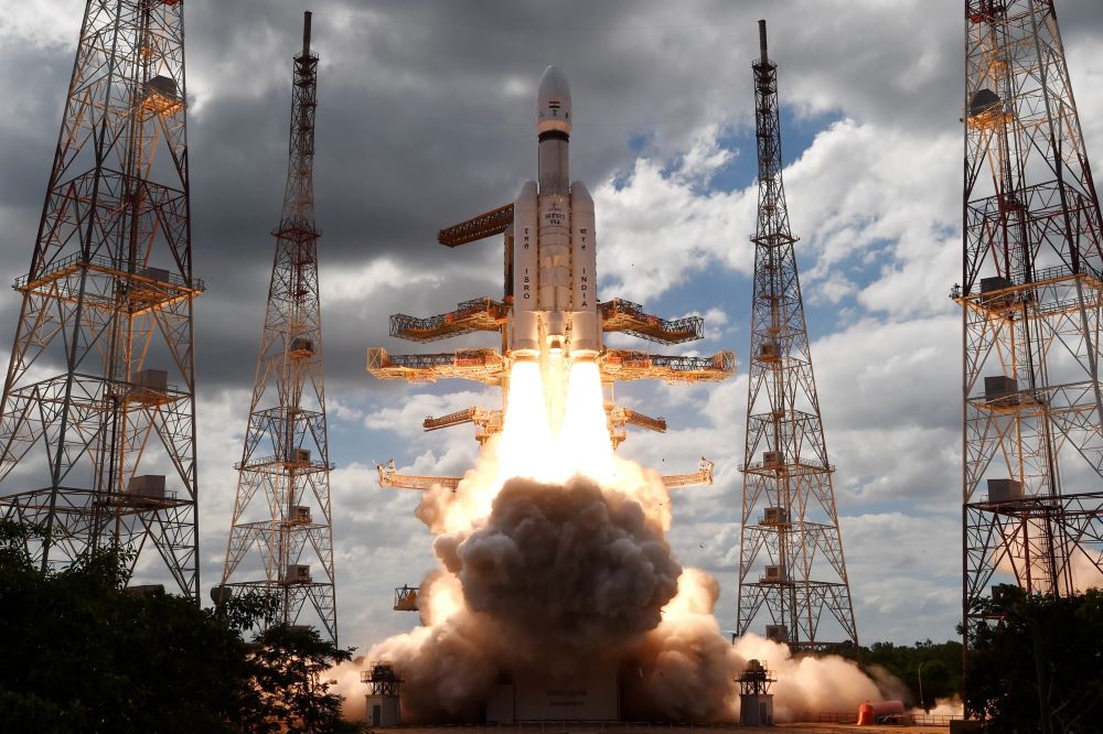
The Chandrayaan-3 spacecraft lifting off for the Moon from the Satish Dhawan Space Center on July 14, 2023. (Credit: Indian Space Resource Organisation (ISRO))
On July 14, 2023, at 2:35 pm Indian Standard Time (5:05 am EST), the Indian Space Resource Organisation (ISRO) successfully launched their Chandrayaan-3 spacecraft from the Satish Dhawan Space Center, which is the primary spaceport of the ISRO. The goal of the mission is to put India’s first lander (Vikram) and rover (Pragyan) on the lunar surface and is scheduled to touch down on the Moon on August 23, 2023. This mission comes after the ISRO’s Chandrayaan-2 Vikram lander crashed on the Moon on September 6, 2019, due to a last-minute guidance software glitch. While the ISRO indicated everything was going according to plan, they unexpectedly lost contact with the Vikram lander approximately 2.1 kilometers (1.3 miles) above the lunar surface.
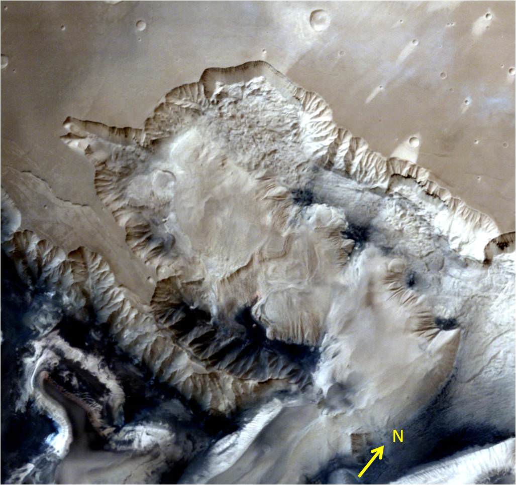
This view over the Ophir Chasma canyon on the Martian surface was taken by the Mars Colour Camera aboard India’s Mars Orbiter Mission (MOM). Ophir Chasma is a canyon in the Coprates quadrangle located at 4° south latitude and 72.5° west longitude. It is part of the Valles Marineris canyon system. Credit: ISRO
India’s space agency has released a spectacular new batch of images taken by everyone’s favorite MOM – the Mars Orbiter Mission – the nation’s first probe ever dispatched to the Red Planet and which achieved orbit nearly a year ago.
The lead image was taken over the Ophir Chasma canyon on the Martian surface by the Mars Colour Camera aboard India’s Mars Orbiter Mission.
Ophir Chasma is a canyon in the Coprates quadrangle located at 4° south latitude and 72.5° west longitude. It is part of the Valles Marineris – the ‘Grand Canyon of Mars’ – and the largest known canyon in the Solar System.
The image was captured on July 19, 2015 from an altitude of 1857 kilometers (1154 miles). It has with a resolution of 96 meters.
The steep walled Ophir Chasma canyon contains many layers and the floors contain large deposits of layered materials, perhaps even sulfates.
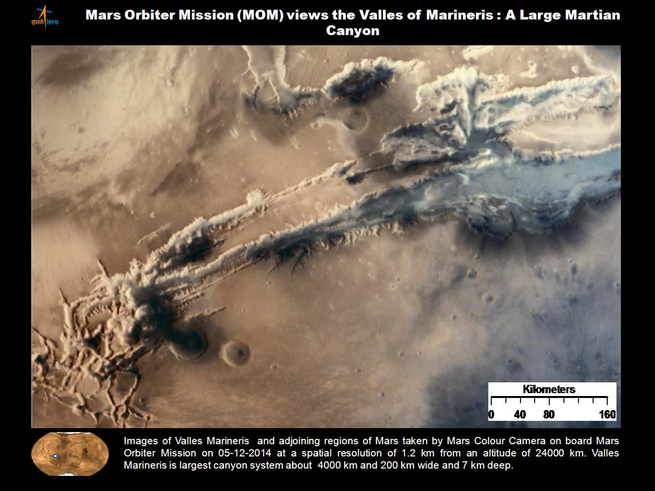
Ophir Chasma is about 317 kilometers long and about 8 to 10 kilometers deep located near the center of Valles Marineris – see map below.
Valles Marineris stretches over 4,000 km (2,500 mi) across the Red Planet, is as much as 600 km wide and measures as much as 10 kilometers (6 mi) deep. It is nearly as wide as the United States.
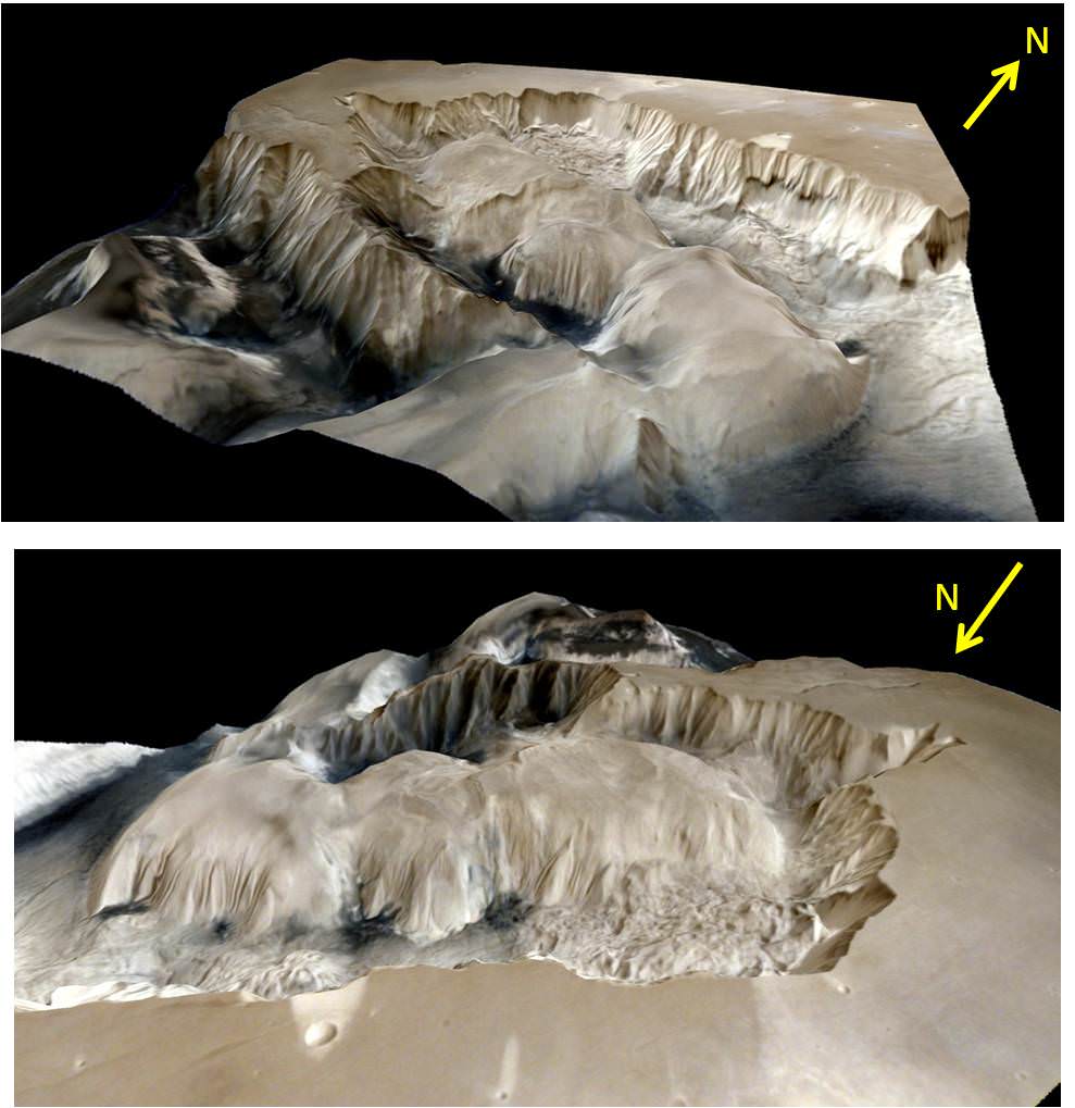
Here’s an illuminating and magnificent 3D portrayal of Ophir Chasma created by Indian scientists that gives a sense of the canyons scale, sheer walls and cliffs and depth:
3D portrayals of Ophir Chasma terrain based on images taken by India’s Mars Orbiter Mission color camera on 19 July 2015 . Credit: ISRO
The newest images were snapped after the spacecraft exited the communications blackout encountered by all of Earth’s invasion fleet of Red Planet orbiters and rovers during the recent conjunction period when Mars was behind the sun during much of June.
See the prior image release from ISRO in my MOM story – here.
Here’s a wider view of Valles Marineris showing Ophir Chasma in a previously published MOM image from ISRO.
Valles Marineris from India’s Mars Mission. Credit: ISRO
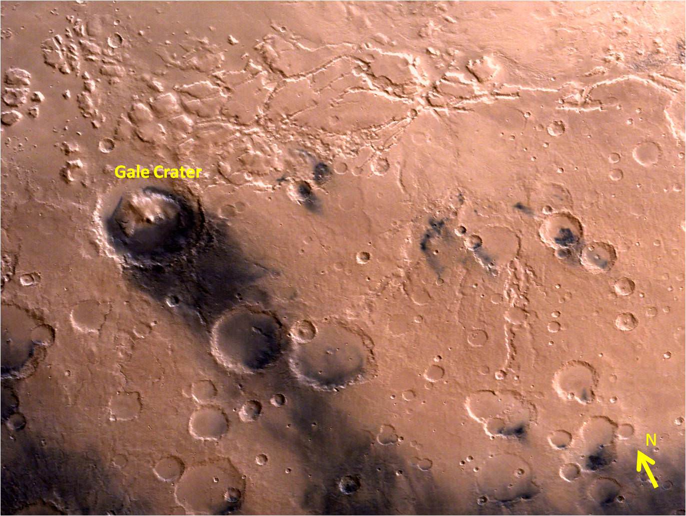
ISRO also released a delightful new image of Gale Crater and the surrounding vicinity.
Gale Crater – landing site of NASA’s Curiosity rover – and vicinity as seen by India’s Mars Orbiter Mission from an altitude of 9004 km. Gale crater is home to humongous Mount Sharp which rises 5.5 km from the crater floor and is easily visible in this photo. Credit: ISRO
Gale Crater is home to humongous Mount Sharp, a mountain that rises 5.5 kilometers (3.4 miles) from the crater floor and is easily visible in the photo from MOM. The crater is 154 kilometers (96 mi) wide.
Curiosity is currently exploring the foothills of Mount Sharp around the top of the image – which shows a rather different perspective from what we’ve seen from prior familiar orbital imagery snapped by several NASA and ESA orbiters.
The 1 ton rover recently celebrated the 3rd anniversary since its nailbiting touchdown inside Gale crater. And the new wider angle image from MOM gives a fabulous sense of exactly why a highly precise landing was essential – otherwise it would have been doomed.
Curiosity recently drilled into the “Buckskin” target at an outcrop at the foothills of Mount Sharp. See the mountain in our ground level mosaic from the crater floor. And its kind of neat to actually imagine Curiosity sitting there while perusing MOM’s photo.
Curiosity extends robotic arm and conducts sample drilling at “Buckskin” rock target at bright toned “Lion” outcrop at the base of Mount Sharp on Mars, seen at right. Gale Crater eroded rim seen in the distant background at left, in this composite multisol mosaic of navcam raw images taken to Sol 1059, July 30, 2015. Navcam camera raw images stitched and colorized. Inset: MAHLI color camera up close image of full depth drill hole at “Buckskin” rock target on Sol 1060. Credit: NASA/JPL-Caltech/MSSS/Ken Kremer/kenkremer.com/Marco Di Lorenzo
MOM’s goal is to study Mars atmosphere, surface environments, morphology, and mineralogy with a 15 kg (33 lb) suite of five indigenously built science instruments. It is also sniffing for methane, a potential marker for biological activity.
MOM is India’s first deep space voyager to explore beyond the confines of her home planets influence and successfully arrived at the Red Planet after the “history creating” orbital insertion maneuver on Sept. 23/24, 2014 following a ten month journey from Earth.
The Indian probe arrived just after NASA’s MAVEN Mars orbiter, the first mission specifically targeted to study Mars tenuous upper atmosphere and the escape rates of atmospheric constituents.
MOM swoops around Mars in a highly elliptical orbit whose nearest point to the planet (periapsis) is at about 421 km and farthest point (apoapsis) at about 76,000 km, according to ISRO.
It takes MOM about 3.2 Earth days or 72 hours to orbit the Red Planet.
MOM was launched on Nov. 5, 2013 from India’s spaceport at the Satish Dhawan Space Centre, Sriharikota, atop the nations indigenous four stage Polar Satellite Launch Vehicle (PSLV) which placed the probe into its initial Earth parking orbit.
The $73 million MOM mission was expected to last at least six months. In March, ISRO extended the mission duration for another six months since its healthy, the five science instruments are operating fine and it has sufficient fuel reserves.
Including MOM, Earth’s invasion fleet at the Red Planet numbers a total of seven spacecraft comprising five orbiters from NASA, ESA and ISRO as well as the sister pair of mobile surface rovers from NASA – Curiosity and Opportunity.
Stay tuned here for Ken’s continuing Earth and planetary science and human spaceflight news.
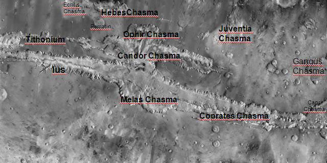
Location of Ophir Chasma canyon inside this annotated map of Valles Marineris created from the THEMIS camera on NASA’s Mars Odyssey orbiter. Credit: NASA
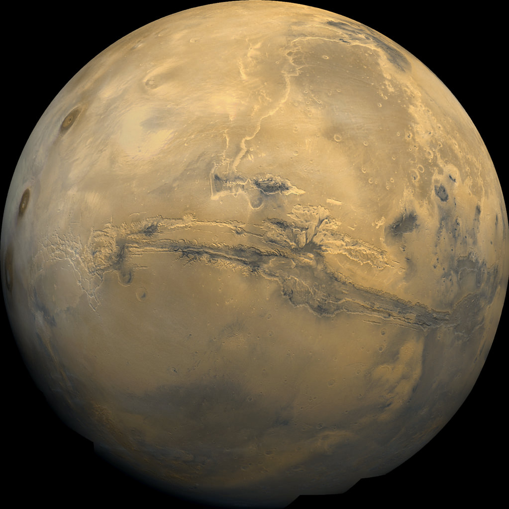
Olympus Mons, Tharsis Bulge trio of volcanoes and Valles Marineris from ISRO’s Mars Orbiter Mission. Note the clouds and south polar ice cap. Credit: ISRO
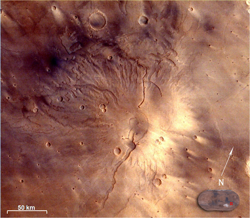
Spectacular 3D view of Arsia Mons, a huge volcano on Mars, taken by camera on India's Mars Orbiter Mission (MOM). Credit: ISRO
Spectacular 3D view of Arsia Mons, a huge volcano on Mars, taken by camera on India’s Mars Orbiter Mission (MOM). Credit: ISRO
Story updated with more details and imagery[/caption]
The Indian Space Research Organization (ISRO), India’s space agency, has recently published a beautiful gallery of images featuring a variety of picturesque Martian canyons, volcanoes, craters, moons and more.
We’ve gathered a collection here of MOM’s newest imagery snapped by the probes Mars Color Camera (MCC) for the enjoyment of Martian fans worldwide.
The spectacular 3D view of the Arsia Mons volcano, shown above, was “created by draping the MCC image on topography of the region derived from the Mars Orbiter Laser Altimeter (MOLA), one of five instruments on board NASA’s Mars Global Surveyor (MGS) spacecraft.
The Arsia Mons image was taken from Mars orbit on 1 April 2015 at a spatial resolution of 556 meters from an altitude of 10707 km. Volcanic deposits can be seen located at the flanks of the Mons, according to ISRO.
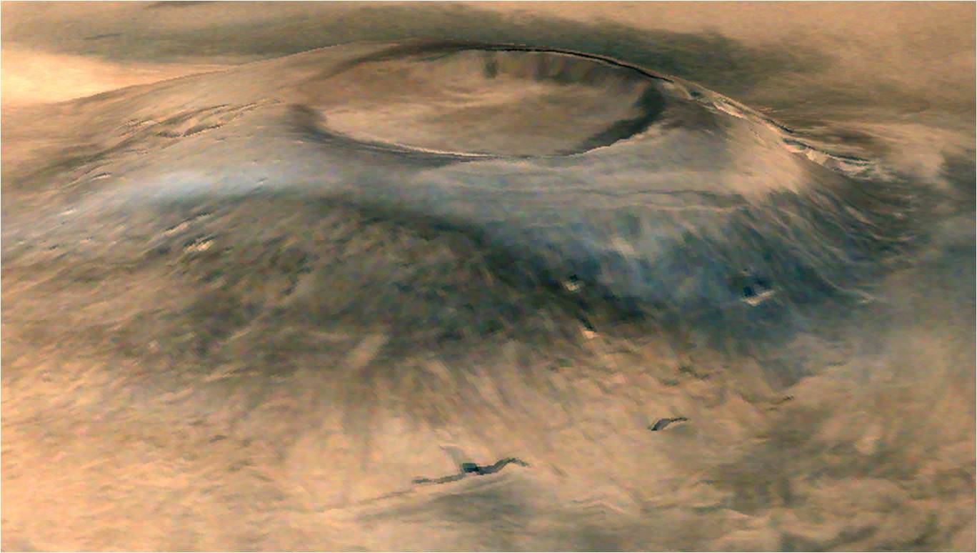
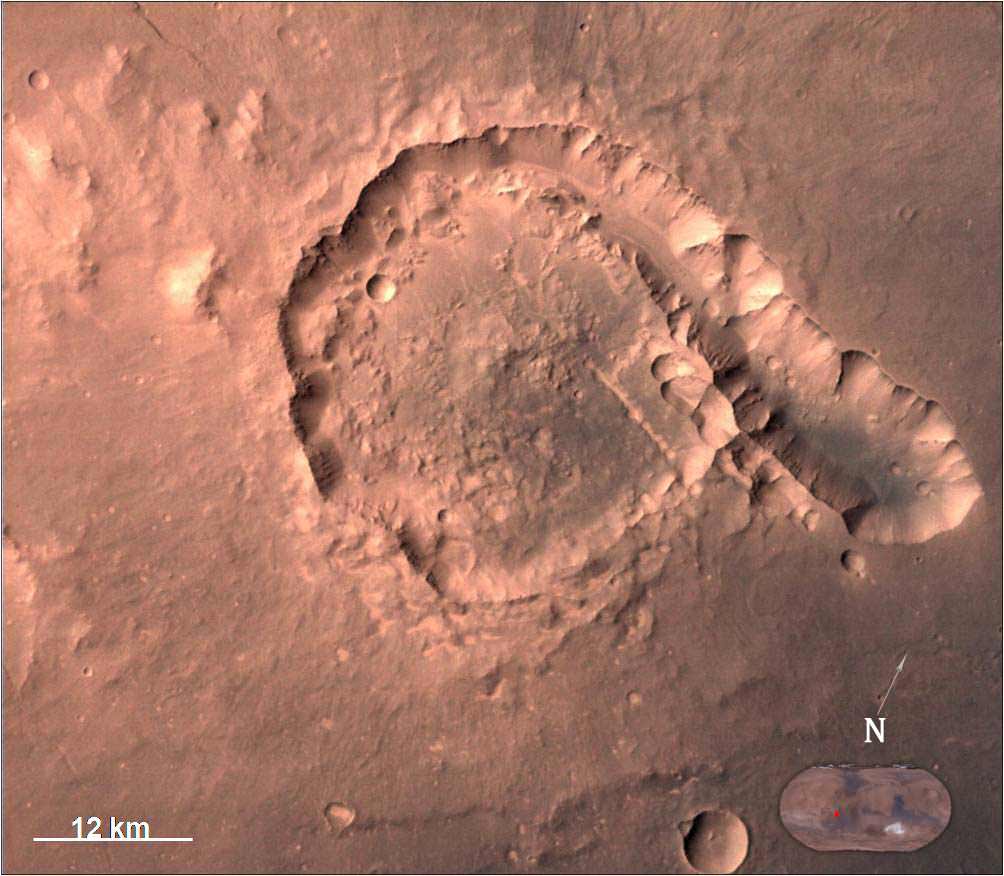
The view of Pital crater below was released in late May and taken on 23 April 2015. Pital is a 40 km wide impact crater located in the Ophir Planum region of Mars and the image shows a chain of small impact craters. It is located in the eastern part of Valles Marineris region, says an ISRO description. MCC took the image from an altitude of 808 km.
Pital crater is an impact crater located in Ophir Planum region of Mars, which is located in the eastern part of Valles Marineris region. This image is taken by Mars Color Camera (MCC) on 23-04-2015 at a spatial resolution of ~42 m from an altitude of 808 km. Credit: ISRO
It is an odd shaped crater, neither circular nor elliptical in shape, possibly due to “regional fracture in the W-E trending fracture zone.”
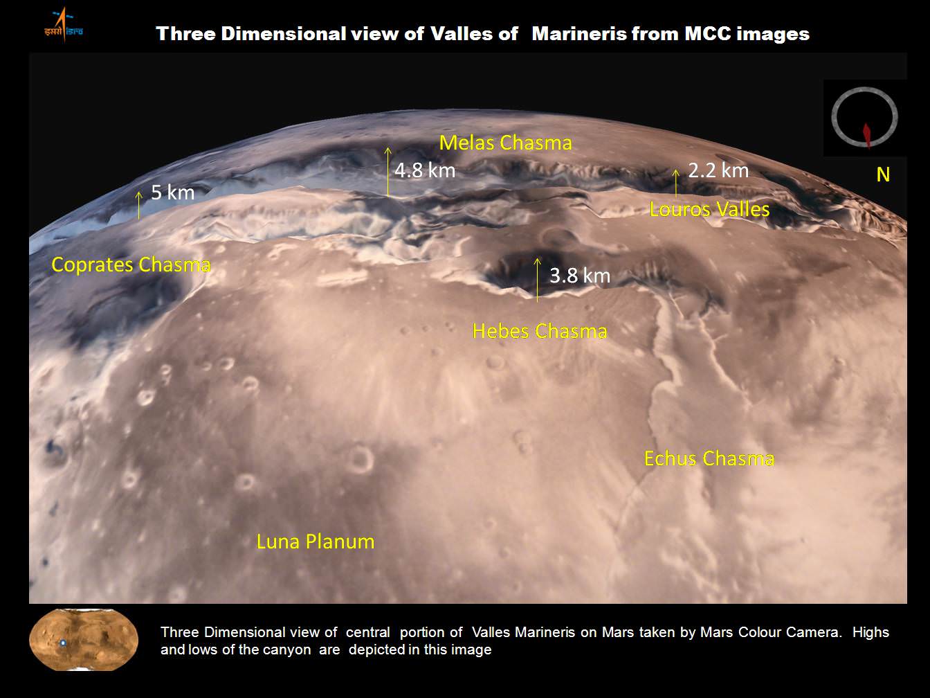
A trio of images, including one in stunning 3D, shows various portions of Valles Marineris, the largest known canyon in the Solar System.
Three dimensional view of Valles Marineris center portion from India’s MOM Mars Mission. Credit: ISRO
Valles Marineris stretches over 4,000 km (2,500 mi) across the Red Planet , is as much as 600 km wide and measures as much as 7 kilometers (4 mi) deep.
Valles Marineris from India’s Mars Mission. Credit: ISRO
For context here’s a previously taken global image of the red planet from MOM showing Valles Marinaris and Arsia Mons, which belongs to the Tharsis Bulge trio of shield volcanoes. They are both near the Martian equator.
Olympus Mons, Tharsis Bulge trio of volcanoes and Valles Marineris from ISRO’s Mars Orbiter Mission. Note the clouds and south polar ice cap. Credit: ISRO
Valles Marineris is often called the “Grand Canyon of Mars.” It spans about as wide as the entire United States.
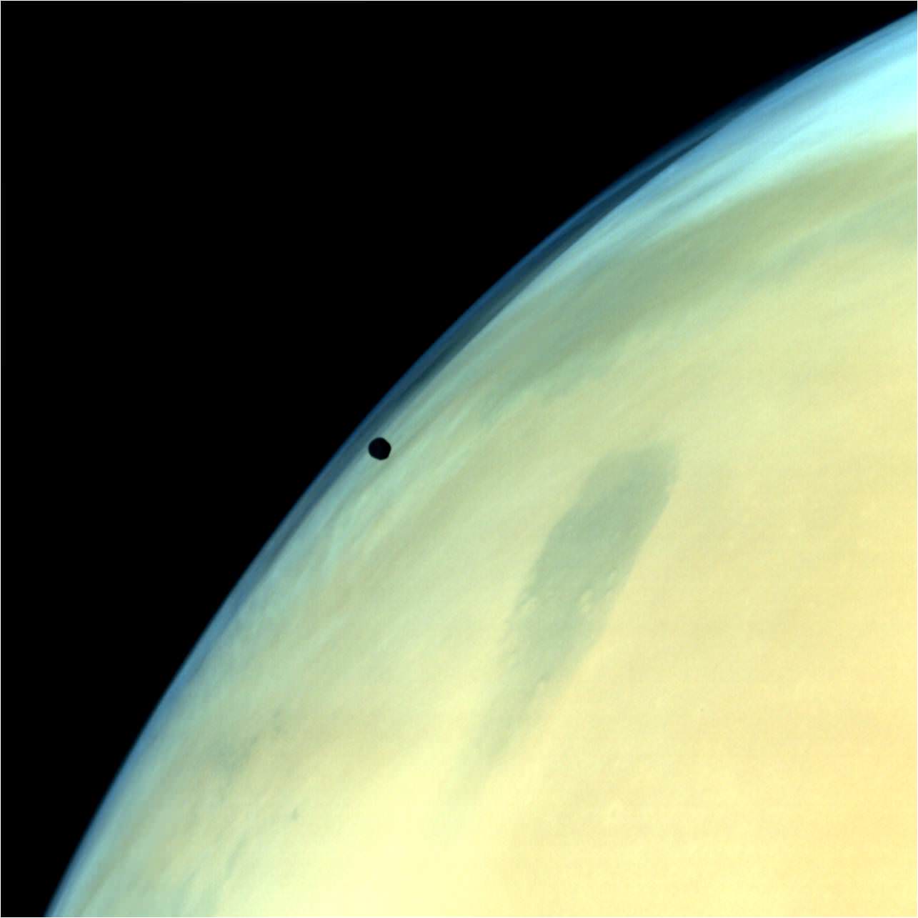
A gorgeous view of Phobos, the largest of Mars’ two tiny moons, silhouetted against the surface is shown below.
Phobos, one of the two natural satellites of Mars silhouetted against the Martian surface. Credit: ISRO
MOM’s goal is to study Mars atmosphere, surface environments, morphology, and mineralogy with a 15 kg (33 lb) suite of five indigenously built science instruments. It is also sniffing for methane, a potential marker for biological activity.
MOM is India’s first deep space voyager to explore beyond the confines of her home planets influence and successfully arrived at the Red Planet after the “history creating” orbital insertion maneuver on Sept. 23/24, 2014 following a ten month journey from Earth. MOM swoops around Mars in a highly elliptical orbit whose nearest point to the planet (periapsis) is at about 421 km and farthest point (apoapsis) at about 76,000 km, according to ISRO.
It takes MOM about 3.2 Earth days or 72 hours to orbit the Red Planet.
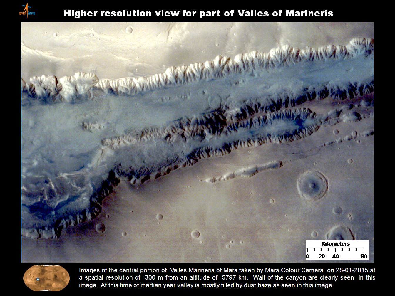
Higher resolution view of a portion of Valles Marineris canyon from India’s MOM Mars Mission. Credit: ISRO
MOM was launched on Nov. 5, 2013 from India’s spaceport at the Satish Dhawan Space Centre, Sriharikota, atop the nations indigenous four stage Polar Satellite Launch Vehicle (PSLV) which placed the probe into its initial Earth parking orbit.
The $73 million MOM mission was expected to last at least six months. In March, ISRO extended the mission duration for another six months since its healthy, the five science instruments are operating fine and it has sufficient fuel reserves.
And with a communications blackout between Mars and Earth imminent as a result of natures solar conjunction, it’s the perfect time to catch up on all things Martian.
Solar conjunctions occur periodically between Mars and Earth about every 26 months, when the two planets line up basically in a straight line geometry with the sun in between as the two planets travel in their sun-centered orbits.
Since Mars will be located behind the Sun for most of June, communications with all the Terran spacecraft at the planet is diminished to nonexistent.
“MOM faces a communication outage during June 8-25,” according to The Hindu.
Normal science operations resume thereafter.
“Fuel on the spacecraft is not an issue,” ISRO Satellite Centre Director M. Annadurai told The Hindu.
Image of Tyrrhenus Mons in Hesperia Planum region taken by Mars Color Camera (MCC) on 25-02-2015 at a spatial resolution of 166m from an altitude of 3192km. Tyrrhenus Mons is an ancient martian volcano and image shows its timeworn gullies and wind streaks. Credit: ISRO
Including MOM, Earth’s invasion fleet at the Red Planet numbers a total of seven spacecraft comprising five orbiters from NASA, ESA and ISRO as well as the sister pair of mobile surface rovers from NASA – Curiosity and Opportunity.
Stay tuned here for Ken’s continuing Earth and planetary science and human spaceflight news.
Olympus Mons, Tharsis Bulge trio of volcanoes and Valles Marineris from ISRO's Mars Orbiter Mission. Note the clouds and south polar ice cap. Credit: ISRO
India’s Mars Orbiter Mission (MOM) has delivered another sweet treat – a stunning view of our Solar System’s largest volcano and the largest canyon.
Just days ago, MOM captured a new global image of the Red Planet dominated by Olympus Mons and Valles Marineris – which is the largest known volcano and the largest known canyon in the Solar System, respectively.
Situated right in between lies a vast volcanic plateau holding a trio of huge volcanoes comprising the Tharsis Bulge: Arsia Mons, Pavonis Mons, and Ascraeus Mons. All four volcanoes are shield volcanoes.
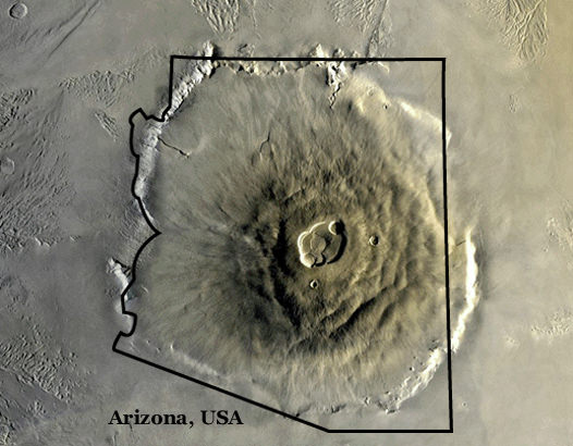
To give an idea of its enormity, Olympus Mons stands about three times taller than Mount Everest and is about the size of Arizona.
Olympus Mons from Mars orbit compared to the state of Arizona. Credit: NASA
Olympus Mons is located in Mars’ western hemisphere and measures 624 kilometers (374 miles) in diameter, 25 km (16 mi) high, and is rimmed by a 6 km (4 mi) high scarp.
Valles Marineris is often called the “Grand Canyon of Mars.” It spans about as wide as the entire United States.
The Indian Space Research Organization (ISRO), India’s space agency which designed and developed the orbiter released the image on Oct. 17, barely two days ahead of the planet’s and spacecrafts’ extremely close encounter with comet Siding Spring.
By the way, a relieved ISRO tweeted MOM’s survival of her close shave with the once-in-a-lifetime cometary passage with gusto, soon after the swingby:
“Phew! Experience of a lifetime. Watched the #MarsComet #SidingSpring whizzing past the planet. I’m in my orbit, safe and sound.”
The new global image was taken by the tri-color camera as MOM swooped around the Red Planet in a highly elliptical orbit whose nearest point to Mars (periapsis) is at 421.7 km and farthest point (apoapsis) at 76,993.6 km, according to ISRO.
To date ISRO has released four global images of the Red Planet, including a 3-D view, reported here.
Olympus Mons, the Tharsis Bulge, and Valles Marineris are near the equator.
Valles Marineris stretches over 4,000 km (2,500 mi) across the Red Planet, is as much as 600 km wide, and measures as much as 7 kilometers (4 mi) deep.
Here’s a comparison view of the region taken by NASA’s Viking 1 orbiter in the 1970s.
Global Mosaic of Mars Centered on Valles Marineris from NASA’s Viking 1 orbiter. Credit: NASA
MOM is India’s first deep space voyager to explore beyond the confines of her home planet’s influence and successfully arrived at the Red Planet only one month ago after the “history creating” orbital insertion maneuver on Sept. 23/24 following a ten month journey.
The $73 million MOM mission is expected to last at least six months.
MOM’s success follows closely on the heels of NASA’s MAVEN orbiter which also successfully achieved orbit barely two days earlier on Sept. 21 and could last 10 years or more.
With MOM’s arrival, India became the newest member of an elite club of only four entities that have launched probes that successfully investigated Mars – following the Soviet Union, the United States, and the European Space Agency (ESA).
Stay tuned here for Ken’s continuing Earth and planetary science and human spaceflight news.
ISRO’s Mars Orbiter Mission captures spectacular portrait of the Red Planet and swirling dust storms with the on-board Mars Color Camera from an altitude of 74,500 km on Sept. 28, 2014. Credit: ISRO
Near-infrared image of the Moon's surface by NASA's Moon Mineralogy Mapper on the Indian Space Research Organization's Chandrayaan-1 mission
Image credit: ISRO/NASA/JPL-Caltech/Brown Univ./USGS
When they first set foot on the Moon, the Apollo 11 astronauts painted a picture of the landscape as a bone-dry desert. So astronomers were naturally surprised when in 2009, three probes showed that a lot of water is locked up in minerals in the soil. There has been some debate as to where the water came from, but now two researchers with the National Museum of Natural History in Paris, France, have determined that most of the water in the soil on the surface of the Moon was formed due to protons in the solar wind colliding with oxygen in lunar dust, rather than from comet or meteorite impacts.
The first hints that there was water on the Moon came when India’s Chandrayaan-1 found hints of water across the lunar surface when it measured a dip in reflected sunlight at a wavelength absorbed only by water and hydroxyl, a molecule that contains one atom of hydrogen and one atom of oxygen.
3-D image of Mars generated from multiple pictures acquired by Mars Color Camera on-board Mars Orbiter Spacecraft on Sept 28, 2014. Credit: ISRO
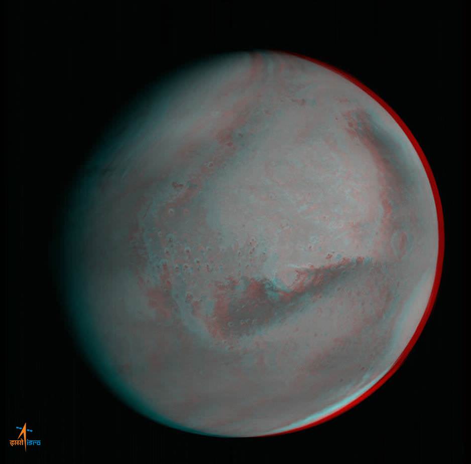
Here’s another breathtakingly glorious view from India’sMars Orbiter Mission (MOM) – her first global 3-D portrait of her new home careening around the Red Planet.
MOM is India’s first deep space voyager to explore beyond the confines of her home planet’s influence and just successfully arrived at the Red Planet after the “history creating” orbital insertion maneuver on Sept. 23/24 following a ten month journey.
This newly released 3-D view from MOM expands upon the initial 2-D global color view of Mars released by the Indian Space Research Organization (ISRO), India’s space agency. See below and detailed in my earlier story – here.
The 3-D image was generated from multiple pictures acquired by MOM’s on-board Mars Color Camera on Sept 28, 2014, from the very high altitude of approximately 74,500 kilometers as the spacecraft orbits Mars.
ISRO’s Mars Orbiter Mission captures spectacular portrait of the Red Planet and swirling dust storms with the on-board Mars Color Camera from an altitude of 74,500 km on Sept. 28, 2014. Credit: ISRO
The images were taken by the tri-color camera as MOM swooped around the Red Planet in a highly elliptical orbit whose nearest point to Mars (periapsis) is at 421.7 km and farthest point (apoapsis) at 76,993.6 km, according to ISRO.
Therefore, the 3-D Red Planet portrait was captured nearly at apoapsis. And being three dimensional, it gives a stereo sense of the huge dust storm swirling over a large swath of the planet’s Northern Hemisphere set against the blackness of space.
Below right is the southern polar ice cap. To see the 3-D effect, whip out your handy pair of left-eye red, right-eye blue color anaglyph glasses.
And while we’re on the subject of spacely 3-D, it’s worth noting that another of humanity’s ground breaking probes currently making news – ESA’s comet hunting Rosetta probe – likewise snapped a glorious 3-D view of Mars way back in 2007, during the brief, but critical, gravity assist slingshot maneuver that flung Rosetta along her vast 10 year path through interplanetary space.
So by way of comparison let’s take a trip down memory lane and be sure to look back at Rosetta’s global 3-D Martian views (below) taken by the high resolution OSIRIS camera on 24 February 2007 at 19:28 CET from a distance of about 240,000 kilometers.
Mars 3-D anaglyph (black & white) taken by ESA’s Rosetta spacecraft during Mars flyby on 24 February 2007 from a distance of about 240,000 km. Image resolution is about 5 km. Credit: MPS for OSIRIS Team MPS/UPD/LAM/ IAA/ RSSD/ INTA/ UPM/ DASP/ IDA
The Rosetta team created both color and black & white 3-D views of Mars.
Mars 3-D anaglyph (color) taken by ESA’s Rosetta spacecraft during Mars flyby on 24 February 2007 from a distance of about 240,000 km. Image resolution is about 5 km. Credit: MPS for OSIRIS Team MPS/UPD/LAM/ IAA/ RSSD/ INTA/ UPM/ DASP/ IDA
And be sure to check out Rosetta’s 2-D true color view showing a different swatch of the Red Planet compared to MOM, along with a more expansive view of the southern polar ice cap.
The first true-color image of Mars from ESA’s Rosetta generated using the OSIRIS orange (red), green and blue color filters. The image was acquired on 24 February 2007 at 19:28 CET from a distance of about 240,000 km; image resolution is about 5 km/pixel. Credit: MPS for OSIRIS Team MPS/UPD/LAM/ IAA/ RSSD/ INTA/ UPM/ DASP/ IDA
The $73 million MOM mission is expected to last at least six months.
MOM’s success follows closely on the heels of NASA’s MAVEN orbiter which also successfully achieved orbit barely two days earlier on Sept. 21 and could last 10 years or more.
Stay tuned here for Ken’s continuing Earth and planetary science and human spaceflight news.
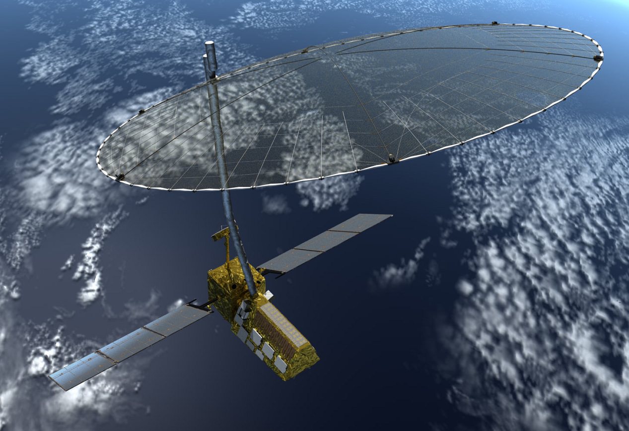
The NASA-ISRO Synthetic Aperture Radar (NISAR) mission, targeted to launch in 2020, will make global measurements of the causes and consequences of a variety of land surface changes on Earth. Image Credit: NASA
ISRO and NASA have inked a deal to collaborate on future missions to jointly explore the Red Planet and our Home Planet hot on the heels of ISRO’s wildly successful Mars Orbiter Mission (MOM), India’s first ever interplanetary voyager to explore Mars.
NASA Administrator Charles Bolden and K. Radhakrishnan, chairman of the Indian Space Research Organisation (ISRO), signed an agreement to collaborate on future science missions to explore Mars as well as to build and launch a joint NASA-ISRO mission to observe Earth.
The leaders of NASA and ISRO met in Toronto, Canada on Tuesday, Sept. 30 and “signed two documents to launch a NASA-ISRO satellite mission to observe Earth and establish a pathway for future joint missions to explore Mars,” according to a NASA statement.
Bolden and Rao met at the International Astronautical Congress underway in Toronto.
ISRO’s Mars Orbiter Mission captures the limb of Mars with the Mars Color Camera from an altitude of 8449 km soon after achieving orbit on Sept. 23/24, 2014. . Credit: ISRO
They signed one agreement defining each agency’s responsibilities for the joint NASA-ISRO Synthetic Aperture Radar (NISAR) mission, targeted to launch in 2020. NISAR will make global measurements of the causes and consequences of land surface changes.
The second agreement “establishes a NASA-ISRO Mars Working Group to investigate enhanced cooperation between the two countries in Mars exploration.”
“The signing of these two documents reflects the strong commitment NASA and ISRO have to advancing science and improving life on Earth,” said NASA Administrator Charles Bolden, in a NASA statement.
“This partnership will yield tangible benefits to both our countries and the world.”
NISAR will be the first Earth observing mission to be equipped two different synthetic aperture radar (SAR) frequencies (L-band and S-band) – one each from NASA and ISRO.
NASA will also provide “the high-rate communication subsystem for science data, GPS receivers, a solid state recorder, and a payload data subsystem.”
ISRO will provide the spacecraft bus and launch vehicle.
The radars will be able to measure subtle changes in Earth’s surface of less than a centimeter across stemming from the flow of glaciers and ice sheets as well as earthquakes and volcanoes.
Regarding Mars, the first subject the joint working group will tackle will be to coordinate observations from each nation’s recently arrived Mars orbiters – ISRO’s MOM and NASA’s MAVEN. They will also examine areas of future collaboration on surface rovers and orbiters.
“NASA and Indian scientists have a long history of collaboration in space science,” said John Grunsfeld, NASA Associate Administrator for Science.
“These new agreements between NASA and ISRO in Earth science and Mars exploration will significantly strengthen our ties and the science that we will be able to produce as a result.”
Stay tuned here for Ken’s continuing Earth and planetary science and human spaceflight news.
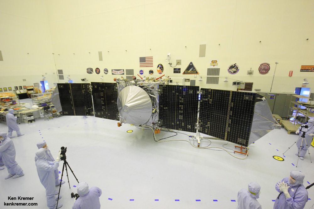
MAVEN is NASA’s next Mars orbiter and launched on Nov. 18, 2014, from Cape Canaveral, Florida. It will study the evolution of the Red Planet’s atmosphere and climate. Universe Today visited MAVEN inside the clean room at the Kennedy Space Center. With solar panels unfurled, this is exactly how MAVEN looks when flying through space and circling Mars and observing Comet Siding Spring. Credit: Ken Kremer/kenkremer.com
ISRO's Mars Orbiter Mission captures spectacular portrait of the Red Planet and swirling dust storms with the on-board Mars Color Camera from an altitude of 74500 km on Sept. 28, 2014. Credit: ISRO
The MOM orbiter was designed and developed by the Indian Space Research Organization (ISRO), India’s space agency, which released the image on Sept. 29.
Even more impressive is that MOM’s Martian portrait shows a dramatic view of a huge dust storm swirling over a large patch of the planet’s Northern Hemisphere against the blackness of space. Luckily, NASA’s Opportunity and Curiosity surface rovers are nowhere nearby.
“Something’s brewing here!” ISRO tweeted.
The southern polar ice cap is also clearly visible.
It was taken by the probe’s on-board Mars Color Camera from a very high altitude of 74,500 kilometers.
ISRO’s Mars Orbiter Mission captures the limb of Mars with the Mars Color Camera from an altitude of 8449 km soon after achieving orbit on Sept. 23/24, 2014. Credit: ISRO
When MOM met Mars, the thrusters placed the probe into a highly elliptical orbit whose nearest point to Mars (periapsis) is at 421.7 km and farthest point (apoapsis) at 76,993.6 km. The inclination of the orbit with respect to the equatorial plane of Mars is 150 degrees, as intended, ISRO reported.
So the Red Planet portrait was captured nearly at apoapsis.
This is the third MOM image released by ISRO thus far, and my personal favorite. And its very reminiscent of whole globe Mars shots taken by Hubble.
MOM’s goal is to study Mars’ atmosphere, surface environments, morphology, and mineralogy with a 15 kg (33 lb) suite of five indigenously built science instruments. It will also sniff for methane, a potential marker for biological activity.
The $73 million mission is expected to last at least six months.
MOM’s success follows closely on the heels of NASA’s MAVEN orbiter which also successfully achieved orbit barely two days earlier on Sept. 21 and could last 10 years or more.
With MOM’s arrival, India became the newest member of an elite club of only four entities who have launched probes that successfully investigated Mars – following the Soviet Union, the United States and the European Space Agency (ESA).
Stay tuned here for Ken’s continuing Earth and planetary science and human spaceflight news.