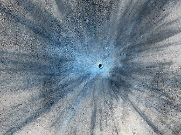
Image of a fresh impact crater with a diameter of approximately 30 meters (100 feet) with corresponding ejecta rays obtained by NASA’s High Resolution Imaging Science Experiment (HiRISE) camera on NASA's Mars Reconnaissance Orbiter on Nov. 19, 2013. (Credit: NASA/JPL-Caltech/Univ. of Arizona)
When we look at the Moon, either through a pair of binoculars, a telescope, or past footage from the Apollo missions, we see a landscape that’s riddled with what appear to be massive sinkholes. But these “sinkholes” aren’t just on the Moon, as they are evident on nearly every planetary body throughout the solar system, from planets, to other moons, to asteroids. They are called impact craters and can range in size from cities to small countries.
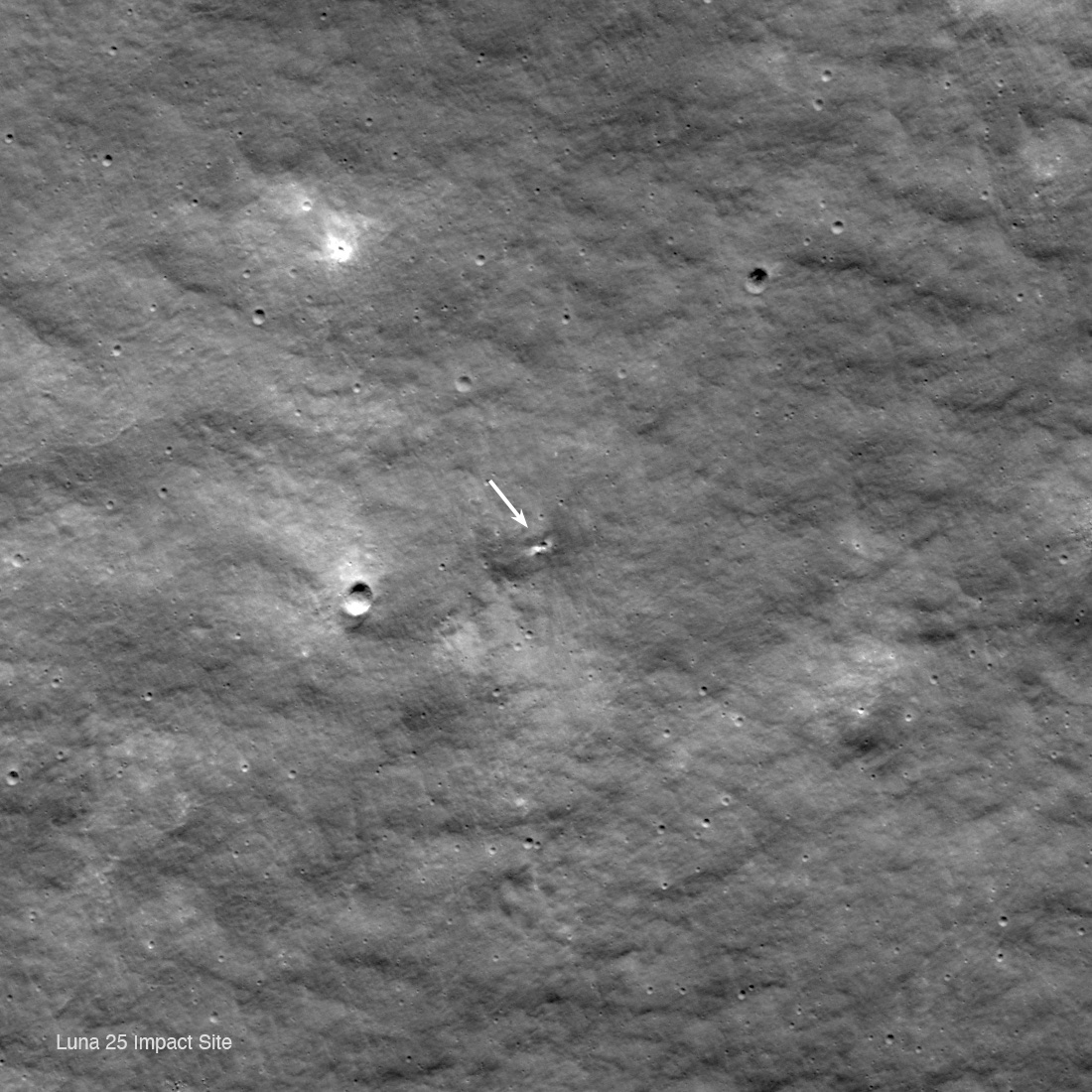
Luna 25's crash site near Pontécoulant G crater. Image Credit: NASA’s Goddard Space Flight Center/Arizona State University
Poor Russia. They can’t seem to get much right. Their most recent failure is their Luna 25 spacecraft. It was supposed to land near the Moon’s south pole but instead crashed into the surface on August 19th.
Now NASA’s Lunar Reconnaissance Orbiter (LRO) has spotted Luna 25’s final resting place.
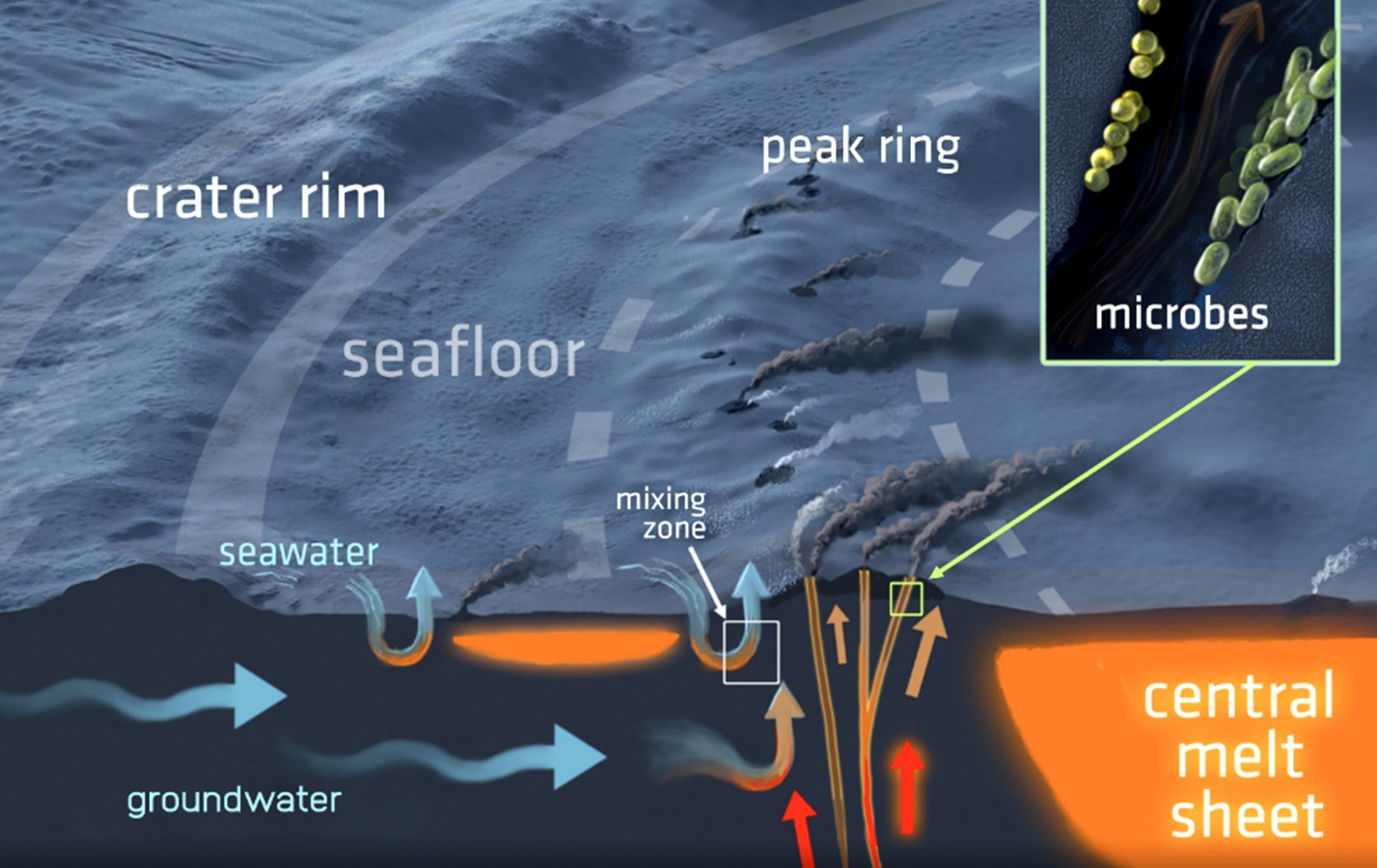
A Three-dimensional cross-section of the hydrothermal system in the Chicxulub impact crater and its seafloor vents. The system has the potential for harboring microbial life. Illustration by Victor O. Leshyk for the Lunar and Planetary Institute.
The Chicxulub impact event was an enormous catastrophe that left a huge imprint on the Earth’s surface. Not only did it cause the mass extinction of the dinosaurs, it left a crater 180 km (112 miles) in diameter, and deposited a worldwide layer of concentrated iridium in the Earth’s crust.
But a new study shows that the impact also left its mark deep underground, in the form of a vast hydrothermal system that modified a massive chunk of the Earth’s crust.
A map of the Australasian strewnfield, where tektites from a meteor impact are spread over the Earth's surface. Image Credit: By syncmedia - Own work, CC0, https://commons.wikimedia.org/w/index.php?curid=19184380
20% of the surface of Earth’s Eastern Hemisphere is littered with a certain kind of rock. Black, glossy blobs called tektites are spread throughout Australasia. Scientists know they’re from a meteorite strike, but they’ve never been able to locate the crater where it struck Earth.
Geologic and paleontological evidence unearthed in southern Chile supports the theory that a major cosmic impact event occurred approximately 12,800 years ago. Credit: UCSB
Roughly 12,800 years ago, planet Earth went through a brief cold snap that was unrelated to any ice age. For years, there have been geologists that have argued that this period was caused by an airburst or meteor fragments (known as the Younger Dryas Impact Theory). This event is beleived to have caused widespread destruction and the demise of the Clovis culture in North American.
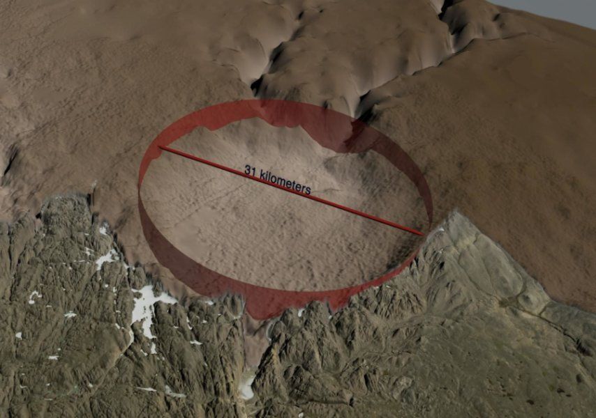
This theory has remained controversial since it was first proposed. However, an international team of scientists recently discovered geological evidence in South America that could settle the debate. As the latest indication of an impact that took place during the Younger Dryas Boundary (YDB) period, this crater indicates that the effects of this event may have been more widespread than previously thought.
The newly-discovered crater is 31 km. across, larger than Paris. Image: NASA's Goddard Space Flight Center.
An international team of scientists have discovered what lay hidden under Arctic ice for thousands or even hundreds of thousands of years. Using data primarily from NASA’s Operation IceBridge, they discovered one of the 25 largest impact craters anywhere on Earth. And its discovery may re-ignite an old climate debate.
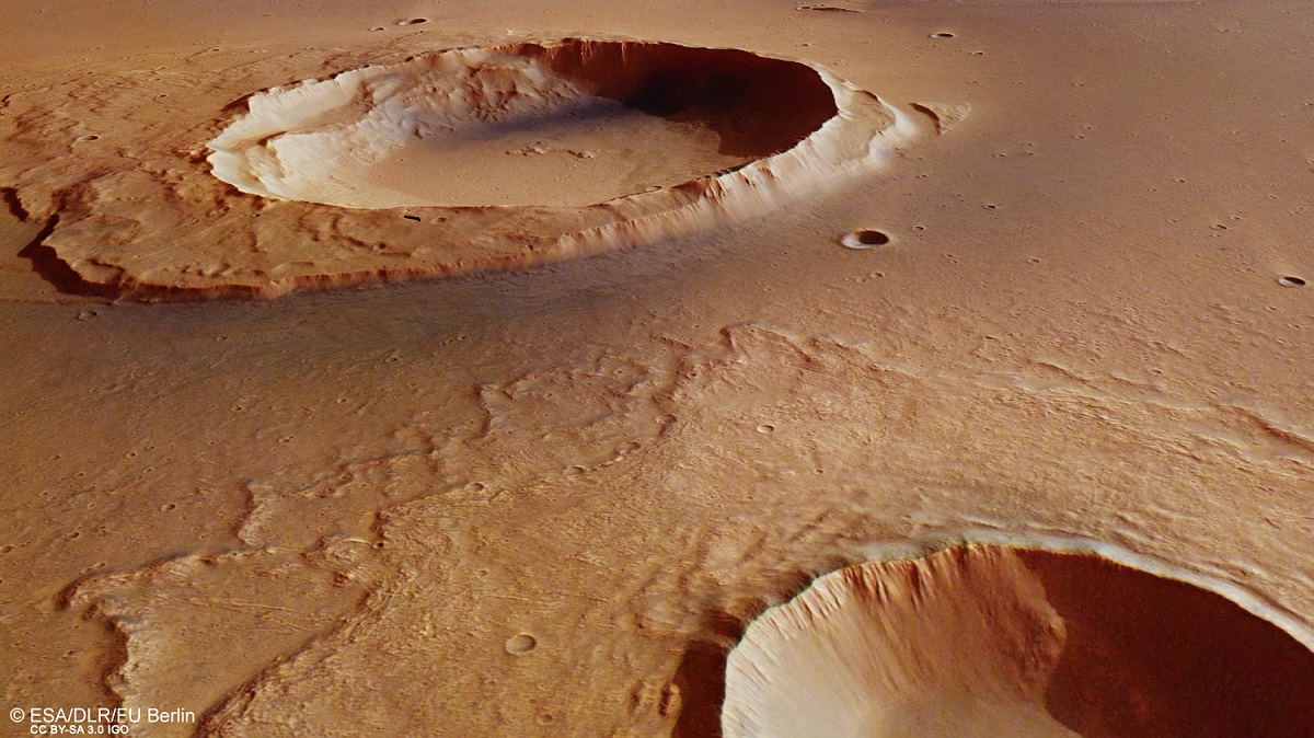
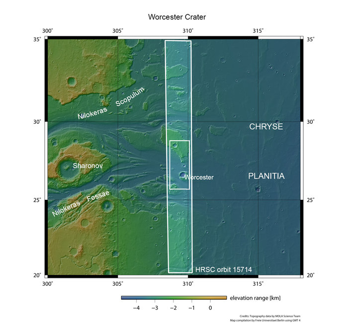
Perspective view looking from an unnamed crater (bottom right) towards the Worcester Crater. The region sits at the mouth of Kasei Valles, where fierce floodwaters emptied into Chryse Planitia. Credit: ESA/DLR/FU Berlin
The Mars Express probe was the European Space Agency’s first attempt to explore Mars. Since its arrival around the Red Planet in 2003, the probe has helped determine the composition of the atmosphere, map the mineral composition of the surface, studied the interaction between the atmosphere and solar wind, and taken many high-resolution images of the surface.
And even after 14 years of continuous operation, it is still revealing interesting things about Mars and its past. The latest find comes from the Kasei Valles region, where the probe captured new images of the giant system of canyons. As one of the largest outflow channel networks on the Red Planet, this region is evidence of a massive flood having taken place billions of years ago.
This region formed between 3.6 and 3.4 billion years ago, when a combination of volcanic and tectonic activity in the Tharsis region triggered groundwater releases from Echus Chasma. This chasm, located in the Lunae Planum plateau, contains clay deposits that indicate the presence of liquid water at one time. This water then flooded through Kasei Valles, emptying into the Chryse Planitia region and leaving behind signs of water erosion.
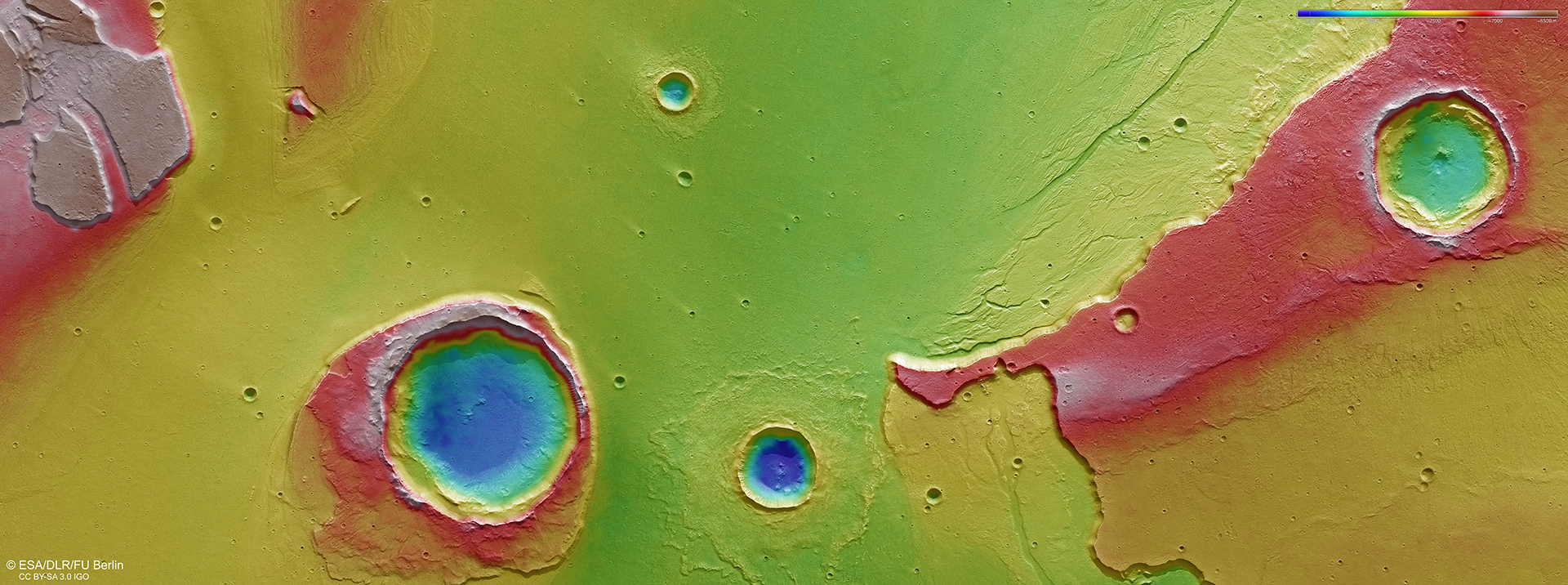
Colour-coded topographic view of the mouth of Kasei Valles, showing the Worcester Crater. Credit: ESA/DLR/FU Berlin.
The Mars Express probe has captured images of this region before. But these latest images, which were snapped n May 25th, 2016, captured the topography of an area that lies at the mouth of the system. Of particular interest was the 25-km-wide Worcester Crater, the remains of an impact that has managed to remain intact despite the erosive force of the mega-flood.
The appearance of this crater and the features around it – which resemble an island – tell us much about the region and its history. For instance, the island has a stepped topography, which is likely the result of its interaction with the flood waters. After the impact threw up material around the crater, moving water pushed it downstream, creating a rigid wall facing towards Kasei Valles and a sloping wall trailing away from it.
The topography of the island is also suggestive of variations in water levels, or possibly different flood episodes. As the water rose and fell, or multiple streams formed over time, the downstream portion of the “island” was affected. There is also the larger crater that appears to the upper right of the image, which sits in a plateau 1 km (0.6 mi) higher than the plains below.
There is a small depression in its center, which would imply that a weaker layer – possibly made of ice – existed under the plateau during the time of impact. This is consistent with the patterns noted in Worcester’s debris blanket, which also suggest the area was rich in water or water-ice during the flooding. The presence of small branch-like channels (aka. dendritic channels) around the plateau are another indication that water levels here varied over time.
Context image shows a region of Mars where Kasei Valles empties into the vast Chryse Planitia. Credit: NASA/MGS/MOLA Science Team
Many smaller craters are also visible in this photo across the mouth of the Kasei Valles region, which also appear to have “tails” of ejected material. This is also true of the crater that sits adjacent to Worchester, who’s debris blanket appears to be largely intact. This would suggest that these craters were formed after the flooding, and any tails that formed were the result of wind.
From all this, it can be concluded that roughly three and a half billion years ago, the mouth of the Kasei Valles region still had water on its surface – possibly still in liquid form but most likely in the form of ice. Volcanic activity – which Mars was still experiencing at the time – then triggered the release of flood waters, which created debris and erosion features throughout the region.
As a result, this latest image manages to capture a preserved record of the geological activity in this region, one which goes back billions of years. And in addition to proving that Mars still had water on its surface, it also confirms that Mars was still experiencing volcanism. It is because of ongoing discoveries like these that the Mars Express mission has been extended several times, the most recent of which extended the mission to end of 2018.
Aerial photo of the crater site, taken with the Polar 6 board camera, while the aircraft was flying 7000 feet above the ice shelf. Credit: Alfred-Wegener-Institut
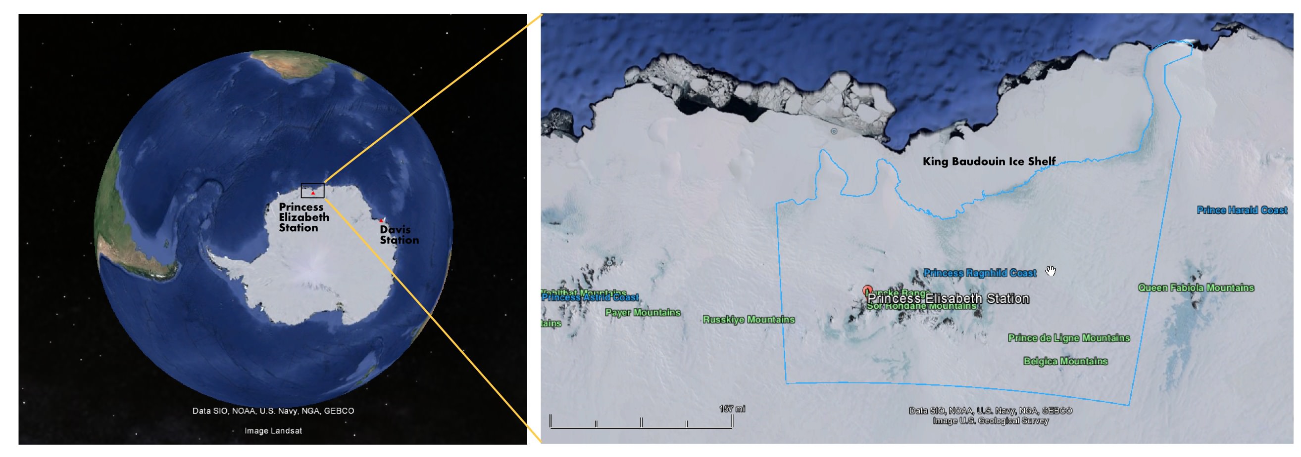
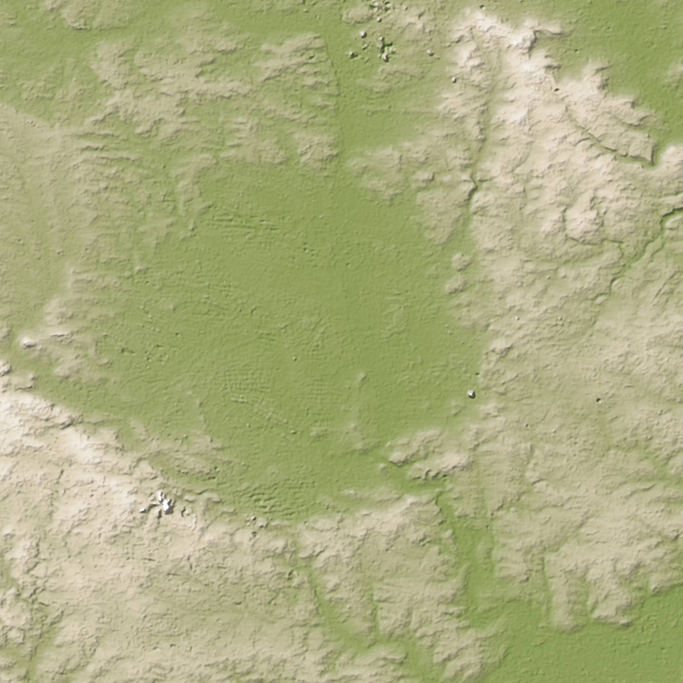
Ever since its discovery was announced earlier this year, the 3 km-wide ring structure discovered on the of Antarctica has been a source of significant interest and speculation. Initially, the discovery was seen as little more than a happy accident that occurred during a survey of East Antarctica by a WEGAS (West-East Gondwana Amalgamation and its Separation) team from the Alfred Wegener Institute.
However, after the team was interviewed by the Brussels-based International Polar Foundation, news of the find and its possible implication spread like wildfire. Initial theories for the possible origin of the ring indicated that it could be the result of the impact of a large meteor. However, since the news broke, team leader Olaf Eisen has offered an alternative explanation: that the ring structure is in fact the result of other ice-shelf processes.
As Eisen indicated in a new entry on the AWI Ice Blog: “Doug MacAyeal, glaciologist from the University of Chicago, put forward the suggestion that the ring structure could be an ice doline.” Ice dolines are round sinkholes that are caused by a pool of melt water formed within the shelf ice. They are formed by the caving in of ice sheets or glaciers, much in the same way that sinkholes form over caves.
“If the melt water drains suddenly,” he wrote, “like it often does, the surface of the glacier is destabilised and does collapse, forming a round crater. Ice depressions like this have been observed in Greenland and on ice shelves of the Antarctic Peninsula since the 1930s.”
Aerial photo of the ringed formation that the AWI researchers found on the Antarctic ice shelf. Credit: Tobias Binder, AWI
However, in glaciers, these cavities form much more rapidly, as the meltwater created by temperature variations causes englacial lakes or water pockets to from which then drains through the ice sheet. Such dolines have been observed for decades, particularly in Greenland and the Antarctic Peninsula where the ice melts during the summertime.
Initial analysis of satellite images appear to confirm this, as they indicate that the feature could have been present before the supposed impact took place around 25 years ago. In addition, relying on data from Google Maps and Google Earth, the WEGAS (West-East Gondwana Amalgamation and its Separation) team observed that the 3 km ring is accompanied by other, smaller rings.
Such formations are inconsistent with meteorite impacts, which generally leave a single crater with a raised center. And as a general rule, these craters also measure between ten to twenty times the size of the meteorite itself – in this case, that would mean a meteorite 200 meters in diameter. This would mean that, had the ring structure been caused by a meteorite, it would have been the largest Antarctic meteor impact on record.
It is therefore understandable why the announcement of this ring structure triggered such speculation and interest. Meteorite impacts, especially record-breaking ones are nothing if not a hot news item. Too bad this does not appear to be the case.
Location of the ring formation on the King Baudouin Ice Shelf off the Antarctic continent. Credit: Google Maps, NOAA
However, the possibility that the ring structure is the result of an ice doline raises a new host of interesting questions. For one, it would indicate that dolines are much more common in East Antarctica than previously thought. Ice dolines were first noticed in the regions of West Antarctica and the Antarctic Peninsula, where rapid warming is known to take place.
East Antarctica, by contrast, has long been understood to be the coldest, windiest and driest landmass on the planet. Knowing that such a place could produce rapid warming that would lead to the creation of a significant englacial lake would certainly force scientists to rethink what they know about this continent.
“To form an ice doline this size, it would need a considerable reservoir of melt water,” Eisen said. “Therefore we would need to ask, where did all this melt water come from? Which melting processes have caused such an amount of water and how does the melting fit into the climate pattern of East Antarctica?”
In the coming months, Eisen and the AWI scientists plant to analyze the data from the Polar 6 (Eisen’s mission) measurements thoroughly, in the hopes of getting all the facts straight. Also, Jan Lenaerts – a Belgian glaciologist with AWI – is planning an land-based expedition to the site; which unfortunately due to the short Antarctic summer season and the preparation time needed won’t be taking place until the end of 2015.
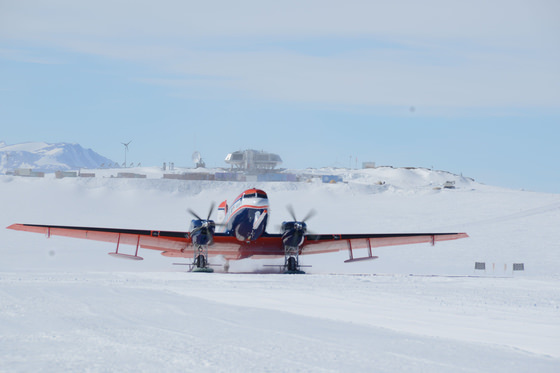
AWI’s Polar 6 aircraft takes off from the runway at the Princess Elisabeth Antarctica research station. Credit: International Polar Foundation / Jos Van Hemelrijck
But what is especially interesting, according to Eisen, is the rapid pace at which the debate surrounding the ring structure occurred. Within days of their announcement, the WEGAS team was astounded by the nature of the debate taking place in the media and on the internet (particularly Facebook), bringing together glaciologists from all around the world.
As Eisen put it in his blog entry, “For the WEGAS team, however, our experience of the last few days has shown that modern scientific discussion is not confined to the ivory towers of learned meetings, technical papers, and lecture halls, but that the public and social media play a tremendous role. For us, cut off from the modern world amongst the eternal ice, this new science seems to have happened at an almost breathtaking pace.”
This activity brought the discussion about the nature of the ring structure forward by several weeks, he claims, focusing attention on the true causes of the surprise discovery itself and comparing and contrasting possible theories.
Aerial view of Nördlinger Ries crater in Germany, a formation so subtle it was not even known as an impact crater until the 1960s. Credit: Credit: Jesse Allen/NASA/GSFC/METI/ERSDAC/JAROS/ASTER
Could life thrive in the devastated rock left behind after a meteorite impact? A new study hints that possibly, that could be the case. Researchers discovered what they think are geological records of biological activity inside of Nördlinger Ries, a crater in Germany that is about 15 miles (24 kilometers) wide.
What the researchers say could be microbial trace fossils — specifically, tiny “tubular features” — were spotted inside the impact glass created after the meteorite impact melted the surrounding rock. These features are tiny — one-millionth to three-millionths of a meter in diameter — and were examined with spectroscopy and scanning electron microscopy to confirm the findings, the team stated.
“The simplest and most consistent explanation of the data is that biological activity played a role in the formation of the tubular textures in the Ries glasses, likely during post-impact hydrothermal activity,” stated post-doctoral fellow Haley Sapers, a post-doctoral scholar at the University of Western Ontario who led the research.
The researchers suggest that on other planets, looking in impact glass might be a good spot to search for tubular features such as the ones they found. The findings are peer-reviewed, but we’ll be interested to see what independent research teams make of the data collected.
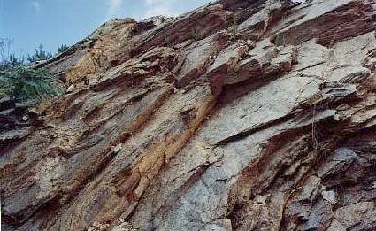
Wetumpka Impact Crater geology. Credit: Auburn Astronomical Society
Video from YouTube User Pam Bergmann
The popular jazz tune “Stars Fell on Alabama” was inspired in part by the Leonid meteor shower in November of 1833, sometimes referred to as “the night the stars fell.” But the central region of Alabama region has a history of meteorite impacts, including a massive impact over 84 million years ago. The town of Wetumpka, Alabama sits in the middle of an ancient 8-kilometer-wide impact crater that was blasted into the bedrock, creating the unique geology of what is now Elmore County.
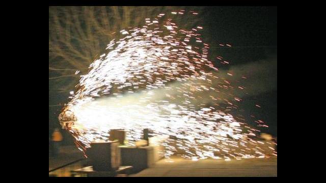
To celebrate this “striking” heritage, Wetumpka celebrates every New Year’s Eve with a spectacular recreation of a falling, exploding meteor.
Geologists have pieced together the events from millions years ago, when an asteroid nearly the size of a football stadium crashed into what was at the time a coastal basin covered with a shallow sea. The jumbled and disturbed geology of the area hadn’t made sense to local geologists since they started studying it in the 1800’s, and they had no explanations until mapping in the early 1970’s showed that the rocky layers were pointing away from a central location, which led them to suspect some sort of large impact.
However, this location wasn’t verified as an impact crater until fairly recently, when core samples drilled in 1998 confirmed the impact by detecting the presence of shocked quartz. The Wetumpka Impact Crater was officially recognized in 2002, and is now considered to be the best preserved marine impact crater ever discovered.
Meteor Drop, Wetumpka, Alabama (TripAdvisor)Credit: Peggy Blackburn The Wetumpka Herald
And so, in honor of this history, the folks of Wetumpka have been ringing in the new year by having their own ‘meteor’ streak across the sky and drop to the ground, guided by a wire and followed by fireworks. This event has been recognized as one of the top 10 unique New Year’s Celebrations in the U.S. by TripAdvisor.