What Is an Earthquake?

The "Global Tectonic and Volcanic Activity of the Last One Million Years" map. Credit: NASA/DTAM

For people who live on or near an active fault line – such as the San Andreas Fault in California, the Median Tectonic Line in Japan, or the Sunda Megathrust of southeast Asia – earthquakes are a regular part of life. Oftentimes, they can take the form of minor tremors that come and go without causing much damage.

But at other times, they are cataclysmic, causing widespread destruction and death tolls in the thousands or more. But what exactly is an earthquake? What geological forces lead to this destructive force? Where do they typically happen, and how many different types are there? And most importantly, how can we be better prepared for them?

Definition:

An earthquake is defined as a perceptible tremor in the surface of the Earth, which is caused by seismic waves resulting from the sudden release of energy in the Earth’s crust. Sometimes, they are detected because of the transfer of this energy to structures, causing noticeable shaking and noise. At other times, they can be violent enough to throw people and level entire cities.

Global earthquake epicenters, 1963–1998. Credit: NASA/DTAM

Generally, the term is used to describe any seismic event that generates seismic waves. An earthquake’s point of initial rupture is called its focus or hypocenter, while the point on the Earth directly above it (i.e. the most immediately-effected area) is called the epicenter.

Causes:

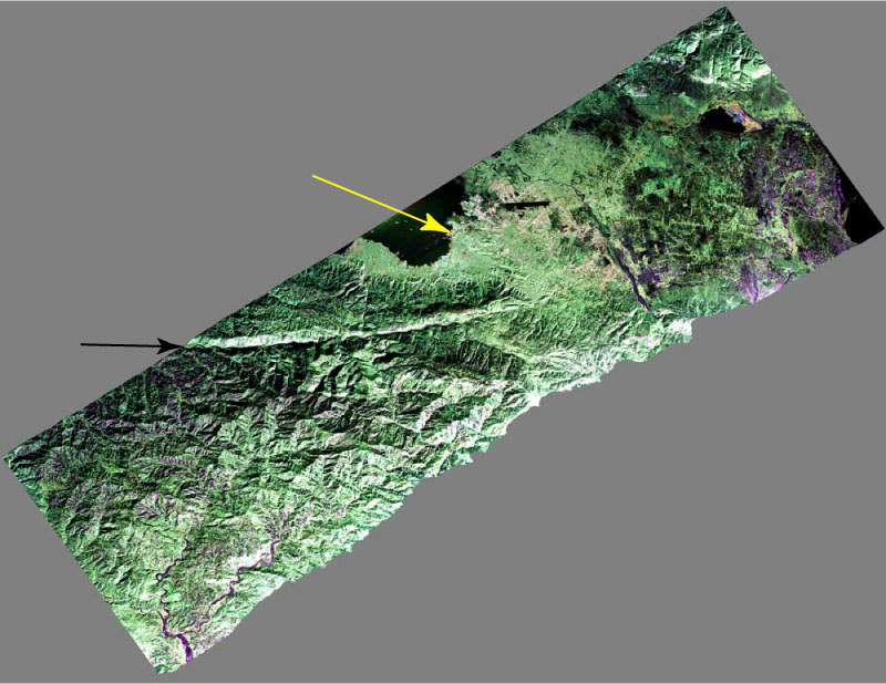
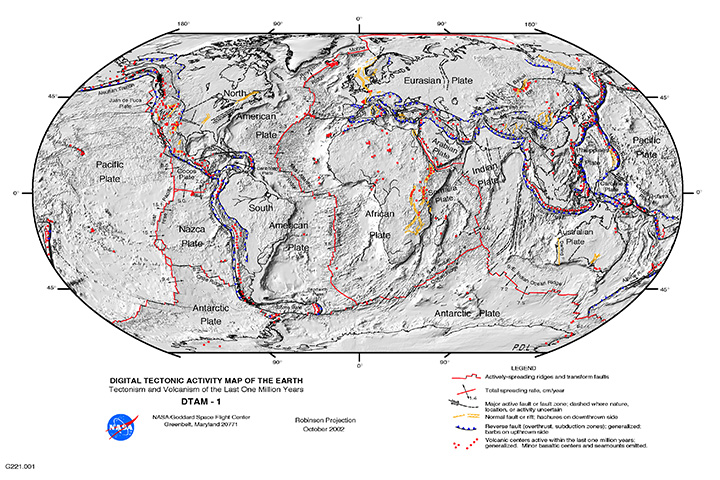
The structure of the Earth’s crust, which is divided into several “tectonic plates”, is responsible for most earthquakes. These plates are constantly in motion due to convection in the Earth’s semi-viscous upper mantle. Over time, these plates will separate and crash into each other, creating visible boundaries called faults.

When plates collide, they remain locked until enough pressure builds that one of them is forced under the other (a process known as subduction). This process occurs over the course of millions of years, and occasionally results in a serious release of energy, frictional heating and cracking along the fault lines (aka. an earthquake).

The energy waves that result are divided into two categories  – surface waves and body waves. Surface waves are so-named because they are the energy that reaches the surface of the Earth, while body waves refer to the energy that remains within the planet’s interior.

The Earth's Tectonic Plates. Credit: msnucleus.org
Map of the Earth’s Tectonic Plates. Credit: msnucleus.org

It is estimated that only 10% or less of an earthquake’s total energy is radiated as seismic energy, while the rest is used to power the fracture growth or is converted into friction heat. However, what reaches the surface triggers all of the effects that we humans associate with earthquakes – i.e. tremors that vary in duration and intensity.

Occasionally, earthquakes can happen away from fault lines. These are due to some plate boundaries being located in regions of continental lithosphere, where deformation is spread out over a much larger area than the plate boundary. Under these conditions, earthquakes are related to strains developed within the broader zone of deformation.

Earthquakes within a plate (called “intraplate earthquakes”) can also happen as a result of internal stress fields, which are caused by interaction with neighboring plates, as well as sedimentary loading or unloading.

Aside from naturally occurring earthquakes (aka. tectonic earthquakes) that occur along tectonic plate lines (fault lines), there are also those that fall under the heading of “human-made earthquakes”. These are all the result of human activity, which is most often the result of nuclear testing.

A 23 kiloton tower shot called BADGER, fired on April 18, 1953 at the Nevada Test Site, as part of the Operation Upshot–Knothole nuclear test series. Credit: NNSA
Earthquakes can also be caused by human-made factors, such as nuclear testing. Credit: NNSA

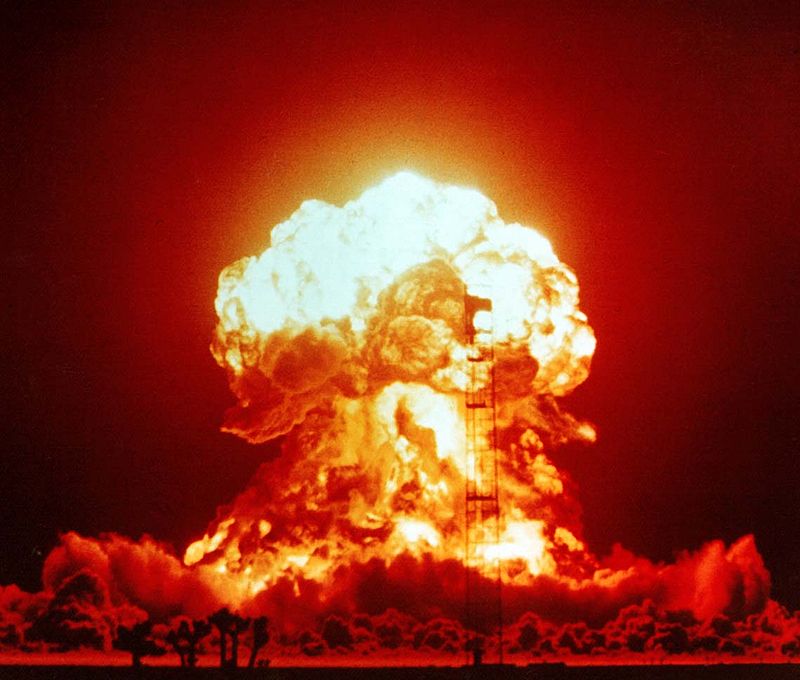
This type of earthquake can been felt all from considerable distance after the detonation of a nuclear weapon. There is very little actual data that is readily available on this type of earthquake, but, compared to tectonic activity, it can be easily predicted and controlled.

Measurements:

Scientists measure earthquakes using seismometers, which measures sound waves through the Earth’s crust. There is also a method of measuring the intensity of an earthquake. It is known as the Richter Scale, which grades earthquakes from 1 to 10 based on their intensity.

Although there is no upper limit to the scale, most people set ten as the upper limit because no earthquakes equal to or greater than ten have been recorded. Scientist hypothesize that level 10 earthquakes were probably more common in prehistoric times, especially as the result of meteor impacts.

Effects of Earthquakes:

Earthquakes can happen on land or at sea, and can therefore trigger other natural disasters. In the case of those that take place on land, displacement of the ground is often the result, which can cause landslides or even volcanoes. When they take place at sea, the displacement of the seabed often results, causing a tsunami.

Map of major earthquakes around the world. Credit: USGS / Google Maps / AJAX / SODA
Map of earthquakes around the world in a seven day period. Credit: USGS / Google Maps / AJAX / SODA

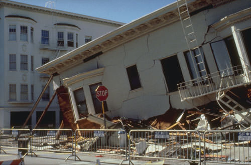
Even though major earthquakes do not happen that often, they can cause substantial damage. In addition to the aforementioned natural disasters they can cause, earthquakes can also trigger fires when gas or electrical lines are damaged and floods when dams are destroyed.

Some of the most devastating earthquakes in history include the 1556 Shaanxi earthquake, which occurred on January 1556 in China. This quake resulted in widespread destruction of housing in the region – most of the housing being dwellings carved directly out of the silt stone mountain – and led to over 830,000 deaths.

The 1976 Tangshan earthquake, which took place in north-eastern China, was the deadliest of the 20th century, leading to he deaths of between 240,000 and 655,000 people. The 1960 Chilean earthquake is the largest earthquake that has been measured on a seismograph, reaching 9.5 magnitude on May 22nd, 1960.

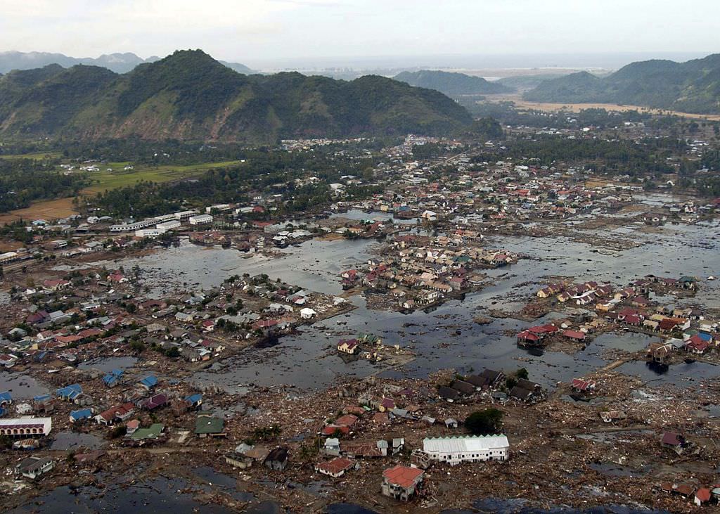
And then there was the 2004 Indian Ocean earthquake, a seismic event that also triggered a massive tsunami that caused devastation throughout southeast Asia. This quake reached 9.1 – 9.3 on the Richter Scale, struck coastal communities with waves measuring up to 30 meters (100 ft) high, and caused the deaths of 230,000 people in 14 countries.

 A village near the coast of Sumatra that was devastated by the 2004 Tsunami. Credit: US Navy
A village near the coast of Sumatra that was devastated by the 2004 Tsunami. Credit: Wikipedia Commons/US Navy

Warning Systems:

More than 3 million earthquakes occur each year, which works out to about 8,000 earthquakes each day. Most of these occur in specific regions, mainly because they usually happen along the borders of tectonic plates. Despite being difficult to predict (except where human agency is the cause) some early warning methods have been devised.

For instance, using seismological data obtained in well-understood fault regions, earthquakes can be reasonably predicted weeks or months in advance. Regional notifications are also used whenever earthquakes are in progress, but before the shocks have struck, allowing people time to seek shelter in time.

Much like volcanoes, tornadoes, and debris flows, earthquakes are a force of nature that is not to be taken lightly. While they are a regular feature of our planet’s geological activity, they have had a considerable impact on human societies. And just like the eruption that buried Pompeii or the Great Flood, they are remembered long after they strike!

We have written many interesting articles about earthquakes here at Universe Today. Here’s Famous Earthquakes, What Causes Earthquakes?, What are Earthquake Fault Lines?, What are the Different Types of Earthquakes? and The Sun Doesn’t Cause Earthquakes,

For more information, you should check out earthquakes and how earthquakes work.

Astronomy Cast has an episode on the subject – Episode 51: Earth

Sources:

Pakistan’s “Earthquake Island” Seen From Space

Mud island off the coast of Gwadar imaged by NASA's EO-1 satellite on Sept. 26, 2013

On the afternoon of Tuesday September 24, 2013, a 7.7-magnitude earthquake struck Balochistan province in southern Pakistan, causing widespread destruction across several districts during more than 2 minutes of powerful tremors and shaking. Sadly at least 400 people were killed (some reports say 600) and over 100,000 have been left homeless. But a weirder — if much less tragic — effect of the quake that was soon reported worldwide was the sudden appearance of a new island off the coast, a mound of mud and bubbling methane seeps rising nearly 20 meters (70 feet) from the ocean surface.

The image above, taken by NASA’s Earth Observing-1 satellite, shows the newly-formed mud island a kilometer (0.6 miles) off the Gwadar coast.

According to an article by the Pakistani news site Dawn.com, the 250-by-100-foot-long pile of mud and rocks is leaking flammable gases.

“Our team found bubbles rising from the surface of the island which caught fire when a match was lit and we forbade our team to start any flame,” said Mohammad Danish, a marine biologist from Pakistan’s National Institute of Oceanography. “It is methane gas.”

Aerial photo of the Gwadar mud volcano (National Institute of Oceanography, Pakistan)

Pakistan’s many earthquakes are the result of collisions between the Indian, Arabian, and Eurasian tectonic plates. These sorts of mud volcanoes are not particularly unusual after large quakes there… it just so happened that this one occurred near a populated coast and in relatively shallow water. (Source)

(In fact two days later another mud island was spotted off the coast of the nearby coastal town of Ormara.)

The mud volcano, which is being called “Zalzala Jazeera” (earthquake island) is not expected to last long. Wave action will eventually sweep the sediment away over the course of several months. (Dawn.com.)

Unfortunately earthquake relief efforts in the remote Taliban-dominated region are being hampered by militant activity.

Image source: NASA Earth Observatory

The Sun Doesn’t Cause Earthquakes

SDO/AIA image of the Sun from April 12

If that title seems like an obvious statement to you, it’s ok… it seems pretty obvious to me too. But there are those who have been suggesting — for quite some time, actually — that earthquakes can be triggered or strengthened by solar activity; that, in fact, exceptionally powerful solar flares, coronal mass ejections, and other outpourings from our home star can cause the planet’s crust to shift, shake, and shudder.

Except that that’s simply not true — at least, not according to a recent study by researchers from the USGS.

Researchers Dr. Jeffrey Love from the United States Geological Survey and Dr. Jeremy Thomas from Northwest Research Associates compared historical data of solar activity with earthquake occurrences around the world and found no definitive correlations… nothing to suggest that one directly influenced the other.

“Recently there’s been a lot of interest in this subject from the popular press, probably because of a couple of larger and very devastating earthquakes. This motivated us to investigate for ourselves whether or not it was true.”

– Jeffrey Love, USGS Research Geophysicist

Even when an earthquake may have been found to occur on the same day as increased solar activity, at other times during even stronger quakes the Sun may have been relatively quiet, and vice versa.

Damage in Anchorage from an earthquake on March 27, 1964. Solar activity at the time was unexceptional. (U.S. Army photo)

“There have been some earthquakes like the 9.5 magnitude Chile quake in 1960 where, sure enough, there were more sunspots and more geomagnetic activity than on average,” said Dr. Love. “But then for the Alaska earthquake in 1964 everything was lower than normal. There’s no obvious pattern between solar activity and seismicity, so our results were inconclusive.”

Basically, even though our planet orbits within the Sun’s outer atmosphere and we are subject to the space weather it creates — and there’s still a lot to be learned about that — observations do not indicate any connection between sunspots, flares, and CMEs and the shifting of our planet’s crust (regardless of what some may like to suggest.)

“It’s natural for scientists to want to see relationships between things,” said Love. “Of course, that doesn’t mean that a relationship actually exists!”

The team’s findings were published in the March 16, 2013 online edition of Geophysical Research Letters.

Read more in Harriet Jarlett’s article on Planet Earth Online, and for results from another study see Dr. Ryan O’Milligan’s article on TheSunToday.org.

(Oh, and the Moon doesn’t cause earthquakes either.)

Japanese Astronomy Pushes on After Hard Year

Artists concept of Japan’s Akatsuki spacecraft at Venus. Credit: JAXA

[/caption]

From faulty spacecraft to two damaged facilities, the past year has been a tough year for Japan’s astronomical programs. Yes despite the setbacks, Japan has already begun working to fix every problem they’ve faced in this difficult year.

The troubles started late last year as Japan’s Venus exploring spacecraft, Akatsuki failed to properly enter orbit around Venus. Ultimately, the failure was blamed on a faulty valve that didn’t allow the thruster to fire for the full length of the burn necessary to transfer into the correct orbit. Instead, the craft is now in a wide orbit around the Sun. The organization in charge of the probe, the Japan Aerospace Exploration Agency (JAXA) announced earlier this month that they will “attempt to reignite the damaged thruster nozzle” and, if the test goes well, can try again for an orbital insertion in November 2015.

The next setback came with the devastating March 11th earthquake which the facilities being used to study the samples returned from the sample and return mission Hayabusa were damaged. While the particles were safe, the sensitive accelerators that are used to study them suffered some damage. Restoration work is already underway and the teams in charge expect some operations to resume as early as this fall. Other instruments may take until early next year to resume operation. Despite the damage, the preliminary data (done before the Earthquake) has confirmed the particles are from the visited asteroid. They contain minerals such as olivine and iron sulfide contained in a rocky-type asteroid. No organic materials have been detected.

More recently, Japan’s flagship observatory, Subaru atop Mauna Kea, Hawaii, was damaged when coolant leaked onto several instruments as well as the primary mirror, halting operations early last month. According to the National Astronomical Observatory of Japan (NAOJ) which maintains the telescope, the mirror was washed with water which was successful in restoring its functionality. The primary camera, the Subaru Prime Focus Camera (Suprime-Cam) and its auxiliary equipment were also affected and are currently being inspected. However, the telescope has a second focus, known as a Nasmyth focus. Several instruments which make use of this focus, including the High Dispersion Spectograph, the 188-element Adaptive Optics system, the Infrared Camera and Spectrograph, and the High Contrast Instrument for the Subaru Next Generation Adaptive Optics, were all unaffected. With the cleaning of the mirror and the use of these instruments, the telescope was able to resume operations on the night of July 22.

With any luck, fortunes will continue to improve for Japan and their hard work and dedication can help them to overcome these issues. Ganbatte!

What are the Different Types Of Earthquakes?

Earthquakes

There are two main types of earthquakes: natural and man-made. Naturally occurring(tectonic) earthquakes occur along tectonic plate lines(fault lines) while man-made earthquakes are always related to explosions detonated by man.

Tectonic earthquakes will occur anywhere there is sufficient stored elastic strain energy to drive fracture propagation along a fault plane. Plate boundaries move past each other smoothly and aseismically if there are no irregularities or asperities along the boundary that increase the frictional resistance; however, most boundaries do have such asperities that lead to stick-slip behavior. Once the boundary has locked, continued relative motion between the plates leads to increasing stress and stored strain energy around the fault surface. The energy increases until the stress breaks through the asperity, suddenly allowing sliding over the plate and releasing the stored energy. This energy is released as a combination of radiated elastic strain seismic waves, frictional heating, and cracking of the rock, which all adds up to an earthquake. This process is called the elastic rebound theory. It is estimated that only 10 percent or less of an earthquake’s total energy is radiated as seismic energy. Most of the earthquake’s energy is used to power the fracture growth or is converted into heat generated by friction.

Occasionally, naturally occurring earthquakes happen away from fault lines. When plate boundaries occur in continental lithosphere, deformation is spread out over a much larger area than the plate boundary, so earthquakes occur away from the plate boundary and are related to strains developed within the broader zone of deformation caused by major irregularities in the fault trace. Also, all tectonic plates have internal stress fields caused by their interactions with neighboring plates and sedimentary loading or unloading. These stresses may be sufficient to cause failure along existing fault planes, giving rise to intraplate earthquakes.

The other type of earthquake is the artificial or man-made quake. This type of quake has been felt all over the world after the detonation of a nuclear weapon. There is very little actual data that is readily available on this type of quake, but, of the two types of of earthquakes it is the only type that can be easily predicted and controlled.

We have written many articles about earthquakes for Universe Today. Here’s an article about how earthquakes happen, and here’s an article about famous earthquakes.

If you’d like more info on earthquakes, check out the U.S. Geological Survey Website. And here’s a link to NASA’s Earth Observatory.

We’ve also recorded related episodes of Astronomy Cast about Plate Tectonics. Listen here, Episode 142: Plate Tectonics.

Sources:
Types of Earthquakes
http://en.wikipedia.org/wiki/Earthquake
http://earthquake.usgs.gov/learn/topics/plate_tectonics/rift_man.php

What are Earthquake Fault Lines?

False-color composite image of the Port-au-Prince, Haiti region, taken Jan. 27, 2010 by NASA’s UAVSAR airborne radar. The city is denoted by the yellow arrow; the black arrow points to the fault responsible for the Jan. 12 earthquake. Image credit: NASA

Every so often, in different regions of the world, the Earth feels the need to release energy in the form of seismic waves. These waves cause a great deal of hazards as the energy is transferred through the tectonic plates and into the Earth’s crust. For those living in an area directly above where two tectonic plates meet, the experience can be quite harrowing!

This area is known as a fault, or a fracture or discontinuity in a volume of rock, across which there is significant displacement. Along the line where the Earth and the fault plane meet, is what is known as a fault line. Understanding where they lie is crucial to our understanding of Earth’s geology, not to mention earthquake preparedness programs.

Definition:

In geology, a fault is a fracture or discontinuity in the planet’s surface, along which movement and displacement takes place. On Earth, they are the result of activity with plate tectonics, the largest of which takes place at the plate boundaries. Energy released by the rapid movement on active faults is what causes most earthquakes in the world today.

The Earth's Tectonic Plates. Credit: msnucleus.org
The Earth’s Tectonic Plates. Credit: msnucleus.org

Since faults do not usually consist of a single, clean fracture, geologists use the term “fault zone” when referring to the area where complex deformation is associated with the fault plane. The two sides of a non-vertical fault are known as the “hanging wall” and “footwall”.

By definition, the hanging wall occurs above the fault and the footwall occurs below the fault. This terminology comes from mining. Basically, when working a tabular ore body, the miner stood with the footwall under his feet and with the hanging wall hanging above him. This terminology has endured for geological engineers and surveyors.

Mechanisms:

The composition of Earth’s tectonic plates means that they cannot glide past each other easily along fault lines, and instead produce incredible amounts of friction. On occasion, the movement stops, causing stress to build up in rocks until it reaches a threshold. At this point, the accumulated stress is released along the fault line in the form of an earthquake.

When it comes to fault lines and the role they have in earthquakes, three important factors come into play. These are known as the “slip”, “heave” and “throw”. Slip refers to the relative movement of geological features present on either side of the fault plane; in other words, the relative motion of the rock on each side of the fault with respect to the other side.

Transform Plate Boundary
Tectonic Plate Boundaries. Credit:

Heave refers to the measurement of the horizontal/vertical separation, while throw is used to measure the horizontal separation. Slip is the most important characteristic, in that it helps geologists to classify faults.

Types of Faults:

There are three categories or fault types. The first is what is known as a “dip-slip fault”, where the relative movement (or slip) is almost vertical. A perfect example of this is the San Andreas fault, which was responsible for the massive 1906 San Francisco Earthquake.

Second, there are “strike-slip faults”, in which case the slip is approximately horizontal. These are generally found in mid-ocean ridges, such as the Mid-Atlantic Ridge – a 16,000 km long submerged mountain chain occupying the center of the Atlantic Ocean.

Lastly, there are oblique-slip faults which are a combination of the previous two, where both vertical and horizontal slips occur. Nearly all faults will have some component of both dip-slip and strike-slip, so defining a fault as oblique requires both dip and strike components to be measurable and significant.

Map of the Earth showing fault lines (blue) and zones of volcanic activity (red). Credit: zmescience.com

Impacts of Fault Lines:

For people living in active fault zones, earthquakes are a regular hazard and can play havoc with infrastructure, and can lead to injuries and death. As such, structural engineers must ensure that safeguards are taken when building along fault zones, and factor in the level of fault activity in the region.

This is especially true when building crucial infrastructure, such as pipelines, power plants, damns, hospitals and schools. In coastal regions, engineers must also address whether tectonic activity can lead to tsunami hazards.

For example, in California, new construction is prohibited on or near faults that have been active since the Holocene epoch (the last 11,700 years) or even the Pleistocene epoch (in the past 2.6 million years). Similar safeguards play a role in new construction projects in locations along the Pacific Rim of fire, where many urban centers exist (particularly in Japan).

Various techniques are used to gauge when the last time fault activity took place, such as studying soil and mineral samples, organic and radiocarbon dating.

We have written many articles about the earthquake for Universe Today. Here’s What Causes Earthquakes?, What is an Earthquake?, Plate Boundaries, Famous Earthquakes, and What is the Pacific Ring of Fire?

If you’d like more info on earthquakes, check out the U.S. Geological Survey Website. And here’s a link to NASA’s Earth Observatory.

We’ve also recorded related episodes of Astronomy Cast about Plate Tectonics. Listen here, Episode 142: Plate Tectonics.

Sources:

Chilean Earthquake May Have Shortened the Length of a Day on Earth

This view of Earth comes from NASA's Moderate Resolution Imaging Spectroradiometer aboard the Terra satellite.

[/caption]

Yikes! Just how big was the magnitude 8.8 earth quake in Chile? One scientist says the shaking may have affected the entire planet by shifting Earth on its axis. This possibly may have shortened the length of a day on Earth by about 1.26 microseconds. Using a complex model JPL research scientist Richard Gross computed how Earth’s rotation should have changed as a result of the Feb. 27, 2010 quake. If his figures are correct, the quake should have moved Earth’s figure axis (the axis about which Earth’s mass is balanced) by 2.7 milliarcseconds (about 8 centimeters, or 3 inches).

Earth’s figure axis is not the same as its north-south axis; they are offset by about 10 meters (about 33 feet). By comparison, Gross said the same model estimated the 2004 magnitude 9.1 Sumatran earthquake should have shortened the length of day by 6.8 microseconds and shifted Earth’s axis by 2.32 milliarcseconds (about 7 centimeters, or 2.76 inches).

Gross said that even though the Chilean earthquake is much smaller than the Sumatran quake, it is predicted to have changed the position of the figure axis by a bit more for two reasons. First, unlike the 2004 Sumatran earthquake, which was located near the equator, the 2010 Chilean earthquake was located in Earth’s mid-latitudes, which makes it more effective in shifting Earth’s figure axis.

Second, the fault responsible for the 2010 Chiliean earthquake dips into Earth at a slightly steeper angle than does the fault responsible for the 2004 Sumatran earthquake. This makes the Chile fault more effective in moving Earth’s mass vertically and hence more effective in shifting Earth’s figure axis.

Gross said the Chile predictions will likely change as data on the quake are further refined.

Source: JPL