ESA’s Mars Express orbiter took images last month of Mars two moons, Phobos and Deimos. This is the first time the moons have been imaged together in high resolution, but as Emily Lakdawalla points out on Planetary Blog, not the first time the two have been imaged together: the Spirit rover did it back in 2005! But these new image definitely provide a ‘wow’ factor, as well as helping to validate and refine existing orbit models of the two moons.
Phobos and Deimos together for the first time in high resolution. Credits: ESA/DLR/FU Berlin (G. Neukum)
“It doesn’t happen very often that both Martian moons are right in front of the camera, directly one behind the other,” said Harald Hoffmann from the German Aerospace Center (DLR).
“During the now more than six-year long project, we have had several opportunities to photograph the two moons together,” said Klaus-Dieter Matz, who worked with Hoffmann to plan the acquisition of these images. “The geometry of the constellation during Orbit 7492 on 5 November 2009 was especially favorable, so this time we wanted to try taking a sequence of photographs – and this first attempt has delivered the expected result!”
The geometrical relationships between Mars, its moons and the Mars Express probe at the time of the sequence. Credit: DLR
Phobos, the larger of the two moons, orbits closer to the Red Planet, circling it every 7 hours and 39 minutes. It travels faster relative to Mars than the Moon relative to Earth. It was 11,800 km from Mars Express when the images were taken. Deimos was 26,200 km away.
The images were acquired with the Super Resolution Channel (SRC) of the High Resolution Stereo Camera (HRSC). The camera took 130 images of the moons on 5 November at 9:14 CET over period of 1.5 minutes at intervals of 1s, speeding up to 0.5-s intervals toward the end. The image resolution is 110 m/pixel for Phobos and 240 m/pixel for Deimos — since Deimos was more than twice as far from the camera.
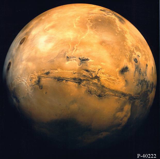
Mars from orbit. Valles Marineris and Volcanic region
[/caption]
A new paper that will be published Wednesday rules out the possibility that methane is delivered to Mars by meteorites, boosting the idea that the short-lived gas perhaps could be generated by either life or water, or maybe even both. Microorganisms living in the Martian soil could be producing methane gas as a by-product of their metabolic processes, or methane might be created as a result of reactions between volcanic rock and water. Either way, the prospect is exciting.
Methane on Mars was first detected in 1999, again in 2001 and 2003, which was widely reported, but not much was known about the origin or amount of the gas on Mars.
In January 2009, scientists analyzing data from telescopic observations and unmanned space missions announced that the methane on Mars is being constantly replenished by an unknown source and they are keen to uncover how the levels of methane are being topped up.
Methane has a short lifetime of just a few hundred years on Mars because it is constantly being depleted by a chemical reaction in the planet’s atmosphere, caused by sunlight.
Some researchers proposed meteorites might be responsible for Martian methane levels because when the rocks enter the planet’s atmosphere they are subjected to intense heat, causing a chemical reaction that releases methane and other gases into the atmosphere.
However, the new study, by researchers from Imperial College London, shows that the volumes of methane that could be released by the meteorites entering Mars’s atmosphere are too low to maintain the current atmospheric levels of methane. Previous studies have also ruled out the possibility that the methane is delivered through volcanic activity.
“Our experiments are helping to solve the mystery of methane on Mars,” said Dr. Richard Court, co-author of the study. “Meteorites vaporizing in the atmosphere are a proposed methane source but when we recreate their fiery entry in the laboratory we get only small amounts of the gas. For Mars, meteorites fail the methane test.”
The team used a technique called Quantitive Pyrolysis-Fourier Transform Infrared Spectroscopy to reproduce the same searing conditions experienced by meteorites as they enter the Martian atmosphere. The team heated the meteorite fragments to 1000 degrees Celsius and measured the gases that were released using an infrared beam.
When quantities of gas released by the laboratory experiments were combined with published calculations of meteorite in-fall rates on Mars, the scientists calculated that only 10 kilograms of meteorite methane was produced each year, far below the 100 to 300 tons required to replenish methane levels in the Martian atmosphere.
The researchers say their study will help NASA and ESA scientists who are planning a joint mission to the red planet in 2018 to search for the source of methane. The researchers say now that they have discovered that meteorites are not a source of Methane on Mars, ESA and NASA scientists can focus their attention on the two last remaining options.
“This work is a big step forward,” said co-author Mark Sephton. “As Sherlock Holmes said, eliminate all other factors and the one that remains must be the truth. The list of possible sources of methane gas is getting smaller and excitingly, extraterrestrial life still remains an option. Ultimately the final test may have to be on Mars.”
This research will be published in the Earth and Planetary Science Letters.
An artist's impression of the Odyssey orbiter around Mars. . Image Credit: NASA
The Mars Odyssey orbiter went into safe mode on Saturday, November 28th because of a glitch in the “memory error external bus” of the satellite. Odyssey will remain in safe mode at least until the end of the week, effectively slowing down communication with the two rovers, Spirit and Opportunity.
Odyssey is still operating at normal temperatures and communicating with the control team back on Earth. It stayed in safe mode over the weekend. After a full reboot today, the craft is on the mend and expected to be fully operational later this week.
“This event is a type we have seen before, so we have a known and tested path to resuming normal operations,” said Odyssey Project Manager Philip Varghese of NASA’s Jet Propulsion Laboratory in a press release.
Odyssey has been orbiting Mars since January 2002, mapping the surface and taking global measurements of the planet. Odyssey has also been the link to the Earth for the two rovers since 2004, acting as a communications relay that speeds up the transference of signals between the robots and the control team. Though Spirit and Oppy have their own antennae for communication, Odyssey can communicate with the Earth at 10 times the speed and with a fraction of the energy usage.
This glitch is really nothing new for the satellite – it’s much like having to reboot your laptop when it freezes up. The Mars Reconnaisance Orbiter would be the obvious backup for Odyssey, but the MRO has been in safe mode since August 26th. The MRO rebooted itself four times in 2009, and after the last reboot the spacecraft has stayed in safe mode to prevent any catastrophic damage to its memory.
NASA had planned to uplink files to the MRO to restore it sometime this week, but the uplink and recalibration of the satellite would take over a week, meaning that if Odyssey isn’t back up by the end of the week Spirit and Opportunity are on their own for a little while longer.
Odyssey is a key player in the efforts to free the Spirit rover, which has been stuck in a sand trap since May 1st of this year but is making progress. Because of a wheel stall problem that the control team thinks may be internal, an extrication attempt made on November 28th wasn’t successful. The Spirit control team hadn’t planned on making any more maneuvers to free the rover this week, as they are still analyzing the recent attempts to plan for future efforts at freeing its wheel.
Hopefully, by the end of next week we’ll be seeing two fully-functioning orbiters and a freewheelin’ Spirit.
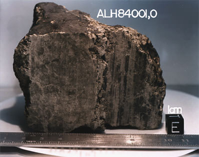
Scientists caused quite a stir in 1996 when they announced a meteorite had been found in Antarctica that might contain evidence for microscopic fossils of Martian bacteria. While subsequent studies of the now famous Allen Hills Meteorite shot down theories that the Mars rock held fossilized alien life, both sides debated the issue and the meteorite is still being studied. Now, Craig Covault in Spaceflightnow.com reports that a new look at ALH84001 provides “evidence that supports the existence of life on the surface of Mars, or in subsurface water pools, early in the planet’s history.” Covault says we can expect a public announcement by NASA Headquarters within a few days.
Research using a more advanced High Resolution Electron Microscopy than was in existence when the initial findings were made 13 years ago has provided the new evidence. Covault reported that the “laboratory sensors are being focused directly on carbonate discs and associated tiny magnetite crystals present inside the meteorite Allen Hills ALH 84001.” The data reveal information that counters a “wide range of opposing theories as to why the finding should not be supported as biological in origin.”
The new findings were reported in the November issue of the respected journal Geochimica et Cosmochimica Acta, the journal of the Geochemical and Meteoritic Society. The authors include Kathie Thomas-Keprta, Simon Clement, David McKay (who led the original team), Everett Gibson and Susan Wentworth, all of the Johnson Space Center.
Covault said the new work centers on what is called magnetic bacteria that on Earth, and Mars as well, leave distinctively-shaped remnants in the rock. These features test with a high chemical purity more like a biological feature than geological.
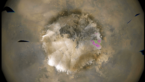
Caption: One frame from an animation of weather patterns around the south pole of Mars. Credit: NASA/JPL-Caltech/MSSS
If you think about it, those hypnotizing patterns of swirling clouds you see in TV weather reports are pretty amazing: satellites let us see what’s happening in the skies all over the world. But these days, that kind of global vision even goes beyond the Earth. The Mars Reconnaissance Orbiter makes daily weather observations of the Red Planet, and mission scientists regularly compile the pictures into movies that are available online. The result is that anyone can follow along as fierce dust storms rage across the plains of Mars, clouds cling to the peaks of towering volcanoes and polar ice advances and retreats.
On board the MRO is a wide-angle camera called the Mars Color Imager (MARCI) that scans the face of Mars in both visible and ultraviolet light. MARCI views Mars from pole to pole, snapping dozens of images every day that are combined into a global map with resolution comparable to weather satellites at home.
This daily weather report helps Mars explorers understand day-to-day events, as well as seasonal and annual changes on the Red Planet. Sometimes the weather watch also gives rover drivers a crucial warning when a storm might be headed in the direction of Spirit or Opportunity.
The weather images can be striking and intriguing. This animation shows the south pole of Mars during a period of about a month earlier this year, when storms raged along the retreating edge of frost in the polar cap. You can see giant, swirling clouds of dust, as well as the changing shape of the cap as it shrinks with the approach of Summer.
Malin Space Science Systems is the firm that built and operates MARCI for NASA’s Jet Propulsion Laboratory. They post weekly movies that show a spinning, global view of the most recent Martian weather. You never know what you’ll see each week, but a careful look often turns up water ice clouds, wind storms or the giant canyon Valles Marineris filled to the brim with dust.
The descriptions that Malin scientists write to accompany each movie are fascinating. They sound both as exotic as a science fiction novel–and as routine as your local weatherman’s report on the evening news. One sample:
“A large dust storm moved south down the Acidalia/Chryse/Xanthe corridor, partially spilling into eastern Valles Marineris at the beginning of the week. From there the storm moved over Thaumasia and Argyre, picking up intensity as it moved into the subtropics of Aonia and Icaria/Daedalia… Dust storms and water-ice clouds also formed in the northern mid-latitudes, with more notable activity occurring over Deuteronilus and Utopia. The increased amount of dust activity on the planet has created a haze that lingers in the atmosphere and has caused skies over both Opportunity and Spirit to be hazy during the past week.”
That’s why Mars fascinates. It’s an alien world that in some ways is tantalizing similar to home.
MARCI will be turned back on in early December after a hiatus of a few months. Previous weather movies are still online.
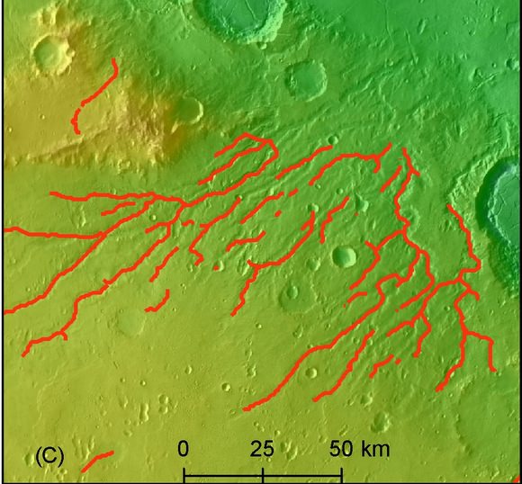
An enhanced network of river valleys on Mars. Credit: NIU, LPI
Did Mars once have a vast network of river valleys – “canals” if you will – and an ocean that covered most of the planet’s northern hemisphere? A new computer-generated map of the Red Planet provides a more detailed look at the valley networks on Mars, and indicates the networks are more than twice as extensive as had been previously depicted in the only other planet-wide map of the valleys. “All the evidence gathered by analyzing the valley network on the new map points to a particular climate scenario on early Mars,” said Wei Luo, from Northern Illinois University (NIU). “It would have included rainfall and the existence of an ocean covering most of the northern hemisphere, or about one-third of the planet’s surface.”
This is a global map depicting the dissection density of valley networks on Mars, in relation to the hypothesized northern ocean. Credit: NIU, LPI
NIU and the Lunar and Planetary Institute in Houston used an innovative computer program to produce the new map that shows regions dissected by the valley networks roughly form a belt around the planet between the equator and mid-southern latitudes, consistent with a past climate scenario that included precipitation and the presence of an ocean covering a large portion of Mars’ northern hemisphere.
Scientists have previously hypothesized that a single ocean existed on ancient Mars, but the issue has been hotly debated.
Luo and Tomasz Stepinski, a staff scientist at the Lunar and Planetary Institute, publish their findings in the current issue of the Journal of Geophysical Research — Planets.
“The presence of more valleys indicates that it most likely rained on ancient Mars, while the global pattern showing this belt of valleys could be explained if there was a big northern ocean,” Stepinski said.
The researchers created an updated planet-wide map of the valley networks by using a computer algorithm that uses topographic data from NASA satellites and recognizes valleys by their U-shaped topographic signature. “The basic idea behind our method is to flag landforms having a U-shaped structure that is characteristic of the valleys,” Stepinski added. “The valleys are mapped only where they are seen by the algorithm.”
Valley networks on Mars exhibit some resemblance to river systems on Earth, suggesting the Red Planet was once warmer and wetter than present.
The networks were discovered in 1971 by the Mariner 9 spacecraft, but scientists have debated whether they were created by erosion from surface water, which would point to a climate with rainfall, or through a process of erosion known as groundwater sapping. Groundwater sapping can occur in cold, dry conditions.
The large disparity between river-network densities on Mars and Earth had provided a major argument against the idea that runoff erosion formed the valley networks. But the new mapping study reduces the disparity, indicating some regions of Mars had valley network densities more comparable to those found on Earth. A zoomed-in area comparing the old map of valley networks and the new one. (Left) A satellite image, with color indicating elevation; (center) the old map of valley networks; (right) the new map of valley networks. Credit: Wei Luo, Northern Illinois University
“It is now difficult to argue against runoff erosion as the major mechanism of Martian valley network formation,” Luo said. “When you look at the entire planet, the density of valley dissection on Mars is significantly lower than on Earth,” he said. “However, the most densely dissected regions of Mars have densities comparable to terrestrial values. The relatively high values over extended regions indicate the valleys originated by means of precipitation-fed runoff erosion—the same process that is responsible for formation of the bulk of valleys on our planet.”
“The only other global map of the valley networks was produced in the 1990s by looking at images and drawing on top of them, so it was fairly incomplete and it was not correctly registered with current datum,” Stepinski said. “Our map was created semi-automatically, with the computer algorithm working from topographical data to extract the valley networks. It is more complete, and shows many more valley networks.”
The Martian surface is characterized by lowlands located mostly in the northern hemisphere and highlands located mostly in the southern hemisphere. Given this topography, water would accumulate in the northern hemisphere, where surface elevations are lower than the rest of the planet, thus forming an ocean, the researchers said.
“Such a single-ocean planet would have an arid continental-type climate over most of its land surfaces,” Luo said.
The northern-ocean scenario meshes with a number of other characteristics of the valley networks.
“A single ocean in the northern hemisphere would explain why there is a southern limit to the presence of valley networks,” Luo added. “The southernmost regions of Mars, located farthest from the water reservoir, would get little rainfall and would develop no valleys. This would also explain why the valleys become shallower as you go from north to south, which is the case.
“Rain would be mostly restricted to the area over the ocean and to the land surfaces in the immediate vicinity, which correlates with the belt-like pattern of valley dissection seen in our new map,” Luo said.
If you’ve ever dreamed of exploring Mars, but are worried about all that pesky radiation exposure and being cramped in a capsule for the two-year flight – or about never coming back – then your dream may be realized with NASA’s “Be a Martian” web site. In the spirit of other citizen scientist collaborations such as Galazy Zoo and Stardust@Home, NASA has created a site that allows you to view and categorize images to help map the Martian surface from the safety of your own home here on Earth.
The Be a Martian site is a collaboration between NASA and Microsoft that uses the tool of crowsourcing to sift through the hundreds of thousands of photos sent back by Mars rovers and orbiters. The format of the site is much like a game, where you complete tasks to earn points and badges.
There are two types of classifying activities to do on the site: count craters and match up images. Counting craters is just like it sounds: you are presented with an image, and place markers on any craters that you see. Counting craters in small regions on the Martian surface will help scientist determine the relative age of these regions – the more craters, the older an area is likely to be.
The image mapping is a bit trickier, though, because you have to match up 2-3 small, but high resolution images onto the background of a larger, much lower resolution image. The user starts in Vallis Marinaris, but can move onto other parts of Mars from there. By helping map the surface, better maps of the surface can be made to help scientists interpret the changing conditions of Mars.
Being a Martian citizen also has some civic responsibilities, too. There is a forum on the site where one can ask questions, vote on questions and make comments to earn “Curiousity Points”. NASA Mars experts will read the questions to see what the virtual Martian community is interested, and will host town hall-type meetings in the future where members can participate.
“We really need the next generation of explorers. And we’re also accomplishing something important for NASA. There’s so much data coming back from Mars. Having a wider crowd look at the data, classify it and help understand its meaning is very important,” Michelle Viotti, from the Jet Propulsion Laboratory told BBC News.
Extras are also available on the site, including wallpapers, mission overviews, and videos. You’ll need to have Microsoft’s Silverlight application for the games and videos on the site to work.
So, if you aren’t already completely addicted to Galaxy Zoo or any other citizen scientist site, now’s your chance! Oh, and if you want your Martian name to be Marvin, too bad – I tried, and it’s already been taken!
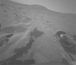
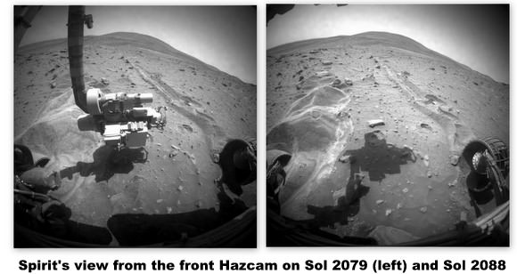
A little good news for Spirit! The rover successfully moved; not very much, but it’s the first step of a planned two-step motion to try and get Spirit free from a sand trap on Mars. On Sol 2090 (Nov. 19), the rover spun its wheels for the equivalent of 2.5 meters (8.2 feet) in the forward direction, and the center of the rover moved approximately 12 millimeters (0.5 inch) forward, 7 millimeters (0.3 inch) to the left and about 4 millimeters (0.2 inch) down. Again, not much, but it’s the first good news and good movement the rover has had in months.
Small forward motion was observed with the non-operable right front wheel, and the left front wheel showed indications of climbing, despite the center of the rover moving downward. These motions are too small to establish any trends at this time.
The drive plan had imposed a limit of 1 centimeter (0.4 inch) motion in any direction. The second step of the drive was not performed, because Spirit calculated it had exceeded that limit.
The data downlink volume from the rover was much better than expected, with all drive-related imagery being received. The team is continuing to analyze results from the drive.
Mission managers sent the drive commands to the Spirit rover at 4 a.m. EST (0900 GMT) today, — Nov. 17, 2009 and Sol 2088 for the rover — but the data back from the rover indicates the rover stopped less than one second after it began moving its wheels when the rover automatically sensed more lateral tilt than permitted. A tight limit on vehicle roll and pitch of less than 1 degree change was set for this first drive, and as the rover began its first move, it sensed that its roll was outside the allowed limit and safely stopped the drive. Those driving the rover say they are starting cautiously, setting initial parameters with very tight limits with the knowledge that these hair triggers may stop the rover frequently. As the project gains confidence with extrication, these limits may be relaxed. From this limited drive the team now has a more accurate measurement of vehicle roll and pitch that will be used for subsequent drive planning. Analysis is continuing. The team hopes to completion their planning of the next drive on Wednesday, Nov. 18, with possible wheel movement again on the 19th (Sol 2090)
At last week’s press conference about the attempt to extricate Spirit from the Martian sand trap, the rover team stressed this procedure could take weeks or months, with the likelihood of not being successful.
Learn more about the process in this video footage of the rover testing and planning teams.
On Monday, Nov. 16, NASA will begin transmitting commands to the Spirit rover on Mars to begin the extrication process to free the rover from where she has been stuck since April 23rd of this year. While members of the rover team have not given up on getting the rover to rove again, they were very guarded at a press conference Thursday in showing any optimism about removing Spirit from her predicament. “Spirit is facing the most challenging situation we have seen on Mars,” said Doug McCuistion director, Mars Exploration Program. “We know a lot of people view Spirit with great affection, and have followed along with the mission and seen new vistas and landscapes along with the rover to uncover new knowledge about our sister planet. But I want everybody to be realistic. This is a serious situation and if it cannot make the great escape from this sandtrap its likely this lonely spot might be where Spirit ends its adventures on Mars.”
John L. Callas, project manager for the rovers said the commands will be sent to Spirit on Monday night, the first drive will be executed early Tuesday, and they should find out later on Tuesday if any progress was made. But don’t expect anything to happen fast. “This is going to be like watching grass grow,” Callas said. “We’ll drive and then follow each drive with detailed analysis to see if it is on trend to what we are expecting. The reality is, we will see very little motion at least initially.”
Callas added that although the rover team has worked for months in the a test bed on Earth with an engineering model of the rover to develop a technique for extricating Sprit, there is no Earth analog for what is going on at Mars. “Spirit is on a planet with almost no atmosphere, 3/8 gravity of Earth, and a vehicle with hard metal wheels that only goes about 2 inches a second. We can’t rock back and forth and take advantage of momentum, and spin the wheels as we steer, like someone would do to get a stuck car out on Earth.” Spirit's location. Image Credit: NASA/JPL-Caltech/Cornell/Ohio State University/University of Arizona
The plan is to attempt to drive the rover forward, which is actually backward, since the rover was driving in reverse when it entered this area where it broke through a “duricrust” and fell through to the talcum powder-like soil. Rover driver Ashley Stroupe said going forward is better because the rover won’t have to break new ground; it will just follow the tracks back out. Plus, then the rover doesn’t have to climb vertically, and if it makes enough progress, eventually it will be heading downhill.
The team did have some good news to share: the “amnesia” Spirit has been experiencing with its flash memory may have been fixed, at least for now. The drive was reformatted and at appears to be working well.
The team said they would try working to remove the rover at least until February before throwing in the towel. A mission review is scheduled at that time.
However, if the rover is destined to remain in this spot forever, lead scientist Ray Arvidson says that’s not all bad. “No place is a nice place to be embedded, but this place is a geological treasure trove,” he said. “The soil is coarse sand with highest sulfate content we have found yet on Mars. Spirit is sitting astride a geological boundary, (see top image — they believe Spirit is sitting on the edge of a small impact crater) and it’s an exciting area to be in scientifically.” Bright soil stirred up by the rover wheels. Credit: NASA/JPL/University of Arizona
Callas said the solar panels are currently at about 60% performance and if no big dust accumulation occurs, Spirit should be able to make it through the next winter if she remains where she is. “But if environmental things change, that could be a problem,” Callas said. “We’re ok now but we really have no margin on that.”


")


 A satellite image, with color indicating elevation; (center) the old map of valley networks; (right) the new map of valley networks. Credit: Wei Luo, Northern Illinois University")