Here’s the view of Hurricane Sandy from an altitude of 254 statute miles from external cameras on the International Space Station. This video was shot as the ISS flew over the US’s eastern seaboard at 12:52 Eastern time October 29, 2012. Sandy has yet to officially make landfall, but the huge storm is already battering a region that makes up the most densely populated area of the US. The combination of three different storms has caused it to be dubbed as “Frankenstorm,” but it could turn into a “Blizzicane” as a winter storm merges with Sandy. The hurricane itself is strengthening as it barrels toward a landfall along the New Jersey coastline.
Below is video of the ISS pass at 11:16 a.m on Monday:
At the time of the flyover, Sandy was located 420 km (260 miles) south-southeast of New York City, moving north-northwest at 18 miles an hour with winds measured at 90 miles an hour as a Category 1 hurricane, according to the National Hurricane Center.
The huge slow moving combination of storms stretches about 1,600 km (1,000 miles) from north to south and significant impacts of storm surge and flooding are expected, with at least 7-10 inches of rain. This comes along with a snow advisory in some regions, creating a “Blizzicane” in the mountains of West Virgina, with 2-4 feet of snow predicted.
Forecasters are predicting this to be a multi-billion dollar storm disaster.
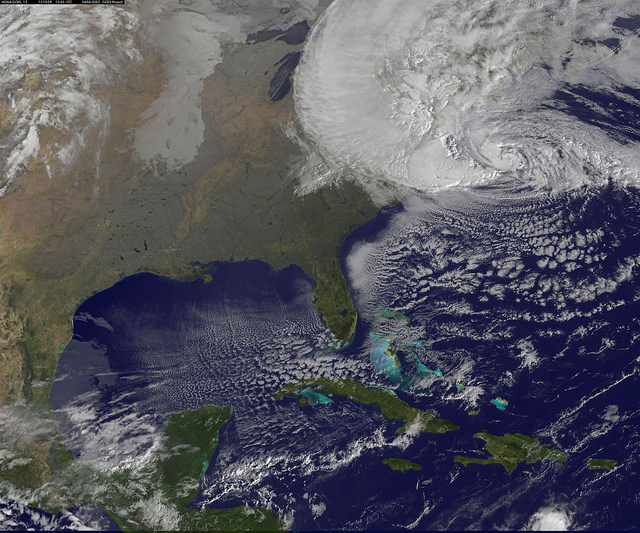
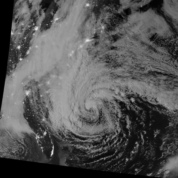
Here are some recent images of the storm:
Satellite View of Hurricane Sandy on Oct. 29 at 9:10 EDT by NOAA’s GOES-13 satellite.
Hurricane Sandy Viewed in the Dark of Night. Image acquired by the Visible Infrared Imaging Radiometer Suite (VIIRS) on the Suomi NPP satellite around 2:42 a.m. Eastern Daylight Time (06:42 Universal Time) on October 28, 2012.
For more images, see the Goddard Space Flight Center’s Flickr page.


The very best of luck to the US Eastern Seaboard.
That’s one big storm. Hope the loss of life is minimal.
We lucked out in NC. The barrier islands got hit hard (as usual) but most of us just got a lot of wind and rain, (not the damaging winds) It went from mid ’80s to mid ’40s in a couple of days. It’s amazing how it pulled the cold air in from the North.
I hope folks in the NY area are doing OK. I imagine they are not well prepared to deal with the floods resulting from the storm surge simply because it has never happened there (in recent history anyway). That’s going to be a helluva cleanup. At the same time, this storm has caused snowfall in the western part of NC! It’s quite humbling to see how one major storm can effect such a widespread area in different ways.