

In addition to being the birthplace of humanity and the cradle of human civilization, Earth is the only known planet in our Solar System that is capable of sustaining life. As a terrestrial planet, Earth is located within the Inner Solar System between between Venus and Mars (which are also terrestrial planets). This place Earth in a prime location with regards to our Sun’s Habitable Zone.
Earth has a number of nicknames, including the Blue Planet, Gaia, Terra, and “the world” – which reflects its centrality to the creation stories of every single human culture that has ever existed. But the most remarkable thing about our planet is its diversity. Not only are there an endless array of plants, animals, avians, insects and mammals, but they exist in every terrestrial environment. So how exactly did Earth come to be the fertile, life-giving place we all know and love?
Size, Mass, and Orbit:
With a mean radius of 6371 km and a mass of 5.97×1024 kg, Earth is the fifth largest and fifth most-massive planet in the Solar System. In essence, it is the largest terrestrial planet, but is smaller and less massive than any of the gas/ice giants of the Outer Solar System. And with a mean density of 5.514 g/cm³, it is the densest planet in the Solar System.
In terms of its orbit, Earth has a very minor eccentricity (approx. 0.0167) and ranges in its distance from the Sun from 147,095,000 km (0.983 AU) at perihelion to 151,930,000 km (1.015 AU) at aphelion. This works out to an average distance (aka. semi-major axis) of 149,598,261 km, which is the basis of a single Astronomical Unit (AU).

The Earth has an orbital period of 365.25 days, which is the equivalent of 1.000017 Julian years. This means that every four years (in what is known as a Leap Year), the Earth calendar must include an extra day. Though technically a full day is considered to be 24 hours long, our planet takes precisely 23h 56m and 4 s to complete a single sidereal rotation (0.997 Earth days).
Viewed from the celestial north pole, the motion of Earth and its axial rotation appear counterclockwise. From the vantage point above the north poles of both the Sun and Earth, Earth orbits the Sun in a counterclockwise direction.
Earth’s axis is tilted 23.439281° away from the perpendicular of its orbital plane, which is responsible for producing seasonal variations on the planet’s surface with a period of one tropical year (365.24 solar days). In addition to producing variations in terms of temperature, this also results in variations in the amount of sunlight a hemisphere receives during the course of a year.
Basically, when the North Pole is pointing towards the Sun, the northern hemisphere experiences summer and the southern hemisphere experiences winter. During the summer, the day lasts longer and the Sun climbs higher in the sky; while in winter, the climate becomes generally cooler, the days are shorter and the Sun appears lower in the sky.
Above the Arctic Circle, an extreme case is reached where there is no daylight at all for part of the year – up to six months at the North Pole itself, which is known as a “polar night”. In the southern hemisphere, the situation is exactly reversed, with the South Pole experiencing a “midnight sun” – i.e. a day of 24 hours.
Earth’s Structure and Composition:
The shape of Earth approximates that of an oblate spheroid, a sphere flattened along the axis from pole to pole such that there is a bulge around the equator. This bulge results from the rotation of Earth, and causes the diameter at the equator to be 43 kilometres (27 mi) larger than the pole-to-pole diameter.
Earth’s interior structure, like that of other terrestrial planets, is differentiated between a metallic core and mantle composed of rock and silicate materials. However, unlike other terrestrial planets, it has a distinct inner core of solid material and a liquid outer core. This inner core has an estimated radius of 1,220 km, while the outer core extends beyond it to a radius of about 3,400 km.
Extending outwards from the core are the mantle and the crust. Earth’s mantle extends to a depth of 2,890 km, making it the thickest layer of Earth. This layer is composed of silicate rocks that are rich in iron and magnesium relative to the overlying crust. Although solid, the high temperatures within the mantle cause the silicate material to be sufficiently ductile that it can flow on very long timescales.
The upper layer of the mantle is divided into the lithospheric mantle (aka. the lithosphere) and the asthenosphere. The former consists of the crust and the cold, rigid, top part of the upper mantle (which the tectonic plates are composed of) while the asthenosphere is the relatively low-viscosity layer on which the lithosphere rides.

The mechanically rigid lithosphere is broken into pieces called tectonic plates. These plates are rigid segments that move in relation to one another at one of three types of plate boundaries. These are known as convergent boundaries, at which two plates come together; divergent boundaries, at which two plates are pulled apart; and transform boundaries, in which two plates slide past one another laterally.
Interactions between these plates are what is responsible for earthquakes, volcanic activity (such as the “Pacific Ring of Fire“), mountain-building, and oceanic trench formation. As the tectonic plates migrate across the planet, the ocean floor is subducted under the leading edges of the plates at convergent boundaries. At the same time, the upwelling of mantle material at divergent boundaries creates mid-ocean ridges. The combination of these processes continually recycles the oceanic crust back into the mantle.
The seven major plates are the Pacific, North American, Eurasian, African, Antarctic, Indo-Australian, and South American. Other notable plates include the Arabian Plate, the Caribbean Plate, the Nazca Plate off the west coast of South America and the Scotia Plate in the southern Atlantic Ocean.
Earth’s Surface Features:
Unlike other planet’s in our Solar System, the majority of Earth’s surface is covered in liquid water. In fact, about 70.8% of the surface – which works out to 361.132 million km² (139.43 million sq mi) – is covered by water, with much of the continental shelf below sea level. The remaining 148.94 million km² (57.5 million sq mi) is above sea level.

Whether it is underwater or above sea level, Earth’s terrain varies greatly from place to place. The submerged surface has mountainous features, as well as undersea volcanoes, oceanic trenches, submarine canyons, oceanic plateaus and abyssal plains. The remaining portions of the surface are covered by mountains, deserts, plains, plateaus, and other landforms.
Over long periods known as geological time, the surface undergoes reshaping due to a combination of tectonic activity and erosion. Those features that are built up or altered by plate tectonics are subject to steady weathering and erosion from precipitation, flowing water, thermal cycles and chemical effects. Glaciation, coastal erosion, the build-up of coral reefs, and large meteorite impacts also act to reshape the landscape.
The continental crust is made up of three kind of lower-density rock material – igneous rock, sedimentary rock, and metaphormic rock. Igneous rock can be subdivided into granite and andesite (which are the most common) and basalt, a denser form of volcanic rock that is less common on the surface but accounts for the majority of the ocean floors.
Sedimentary rock, which makes up 75% of continental surfaces (though only 5% of the crust), is formed when accumulated sediment is buried and is compacted. Metaphormic rock is the result of igneos and/or sedimentary rock undergo transformation due to heat and pressure, and go on to form materials like gneiss, slate, marble, schist, and quartzite.

The elevation of the land surface varies from the lowest point of -418 m (at the Dead Sea) to the estimated maximum altitude of 8,848 m at the top of Mount Everest. The average height of land above sea level is 840 m. Commonly, the planet is divided between northern and southern hemisphere, though the somewhat arbitrary division between eastern and western hemispheres is also acknowledged. The Earth’s land masses are also divided between the seven continents of Africa, Asia, Australia, Europe, North, South America and Antarctica.
The outermost layer of the Earth’s surface (known as the pedosphere) is where soil exists, a combination of minerals and organic compounds. This layer exists as the interface between the lithosphere, atmosphere, hydrosphere (all watery surfaces in the world) and biosphere (where all terrestrial life exists).
The total amount of arable land makes up approximately 13.31% of the Earth’s surface, with 4.71% supporting permanent crops. Close to 40% of Earth’s land is used for cropland and pasture, or an estimated 1.3×10⁷ km2 being used for cropland and 3.4×10⁷ km2 for pastureland.
Earth’s Atmosphere:
Earth’s atmosphere is made up of five main layers – the Troposphere, the Stratosphere, the Mesosphere, the Thermosphere, and the Exosphere. As a rule, air pressure and density decrease the higher one goes into the atmosphere and the farther one is from the surface. However, the relationship between temperature and altitude is more complicated, and may even rise with altitude in some cases.
![Space Shuttle Endeavour sillouetted against the atmosphere. The orange layer is the troposphere, the white layer is the stratosphere and the blue layer the mesosphere.[1] (The shuttle is actually orbiting at an altitude of more than 320 km (200 mi), far above all three layers.) Credit: NASA](https://www.universetoday.com/wp-content/uploads/2012/03/Endeavour_silhouette_STS-130.jpg)
The troposphere contains roughly 80% of the mass of Earth’s atmosphere, with some 50% located in the lower 5.6 km (3.48 mi), making it denser than all its overlying atmospheric layers. It is primarily composed of nitrogen (78%) and oxygen (21%) with trace concentrations of water vapor, carbon dioxide, and other gaseous molecules. Nearly all atmospheric water vapor or moisture is found in the troposphere, so it is the layer where most of Earth’s weather takes place.
The Stratosphere extends from 12 to 50 km (7 to 31 mi) and is separated from the Troposphere by the tropopause – a boundary marked in most places by a layer of relatively warm air above a colder one, and in others by a zone where the temperature is constant regardless of altitude. This layer extends from the top of the troposphere to the stratopause, which is at an altitude of about 50 to 55 km (31 to 34 mi). At this altitude, the air pressure is roughly 1/1000th what it is at sea level.
This layer of the atmosphere is home to the ozone layer, which is the part of Earth’s atmosphere that contains relatively high concentrations of ozone gas. The stratosphere defines a layer in which temperatures rise with increasing altitude, which is caused by the absorption of ultraviolet (UV) radiation from the Sun by ozone particles.
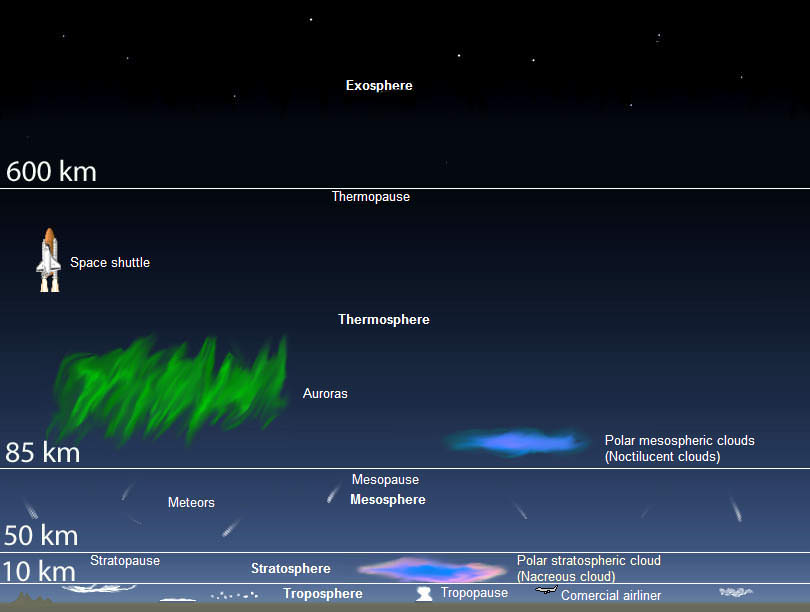
This layer of atmosphere is very stable, thanks to a consistent temperature profile. Hence, this region of the atmosphere is virtually free of weather-producing air turbulence, clouds, or any other forms of weather or weather-producing phenomena. This is also the highest layer of the atmosphere that can be accessed by jet-powered aircraft.
Next is the Mesosphere, which extends from a distance of 50 to 80 km (31 to 50 mi) above sea level. Here, temperatures drop with increasing altitude to the mesopause, which marks the top of this middle layer of the atmosphere. It is the coldest place on Earth and has an average temperature of around -85 °C (-120 °F; 190 K).
The Thermosphere, the second highest layer of the atmosphere, is next to the mesopause. This layer extends from an altitude of about 80 km (50 mi) up to the thermopause, which is at an altitude of 500–1000 km (310–620 mi). The lower part of the thermosphere, from 80 to 550 kilometers (50 to 342 mi), contains the ionosphere – which is so named because it is here in the atmosphere that particles are ionized by solar radiation.
At this level, temperature increases with height. But unlike the stratosphere, which experience temperature inversion due to the adsorption of UV radiation by ozone, the inversion at this layer is due to the extremely low density of its molecules. So while temperatures in the thermosphere can rise as high as 1500 °C (2700 °F), the spacing of the gas molecules means that it would not feel hot to a human who was in direct contact with the air.
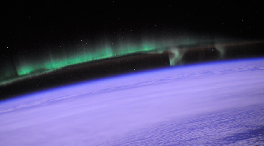
This layer is completely cloudless and free of water vapor. It is also at this altitude that the phenomena known as Aurora Borealis and Aurara Australis are known to take place. The International Space Station also orbits in this layer, between 320 and 380 km (200 and 240 mi).
The Exosphere, which is outermost layer of the Earth’s atmosphere, extends from the exobase – located at the top of the thermosphere at an altitude of about 700 km above sea level – to about 10,000 km (6,200 mi). The exosphere merges with the emptiness of outer space, where there is no atmosphere.
This layer is mainly composed of extremely low densities of hydrogen, helium and several heavier molecules including nitrogen, oxygen and carbon dioxide (which are closer to the exobase). The atoms and molecules are so far apart that the exosphere no longer behaves like a gas and the particles constantly escape into space. These free-moving particles follow ballistic trajectories and may migrate in and out of the magnetosphere or with the solar wind.
The exosphere is located too far above Earth for any meteorological phenomena to be possible. However, the Aurora Borealis and Aurora Australis sometimes occur in the lower part of the exosphere, where they overlap into the thermosphere. The exosphere contains most of the satellites orbiting Earth.
Earth’s Average Temperature:
The average temperature on the surface of Earth depends on a number of factors. These include the time of day, the time of year, and where the temperatures measurements are being taken. Given that the Earth experiences a sidereal rotation of approximately 24 hours – which means one side is never always facing towards the Sun – temperatures rise in the day and drop in the evening, sometimes substantially.
And given that Earth has an inclined axis (approximately 23.4° towards the Sun’s equator), the Northern and Southern Hemispheres of Earth are either tilted towards or away from the Sun during the summer and winter seasons, respectively. And given that equatorial regions of the Earth are closer to the Sun, and certain parts of the world experience more sunlight and less cloud cover, temperatures range widely across the planet.
However, not every region on the planet experiences four seasons. At the equator, the temperature is on average higher and the region does not experience cold and hot seasons in the same way the Northern and Southern Hemispheres do. This is because the amount of sunlight the reaches the equator changes very little during the course of the year.

The average surface temperature on Earth is approximately 14°C; but as already noted, this varies. For instance, the hottest temperature ever recorded on Earth was 70.7°C (159°F), which was taken in the Lut Desert of Iran. These measurements were part of a global temperature survey conducted by scientists at NASA’s Earth Observatory during the summers of 2003 to 2009. For five of the seven years surveyed (2004, 2005, 2006, 2007, and 2009) the Lut Desert was the hottest spot on Earth.
However, it was not the hottest spot for every single year in the survey. In 2003, the satellites recorded a temperature of 69.3°C (156.7°F) – the second highest in the seven-year analysis – in the shrublands of Queensland, Australia. And in 2008, a yearly maximum temperature of 66.8°C (152.2°F) recorded on the Flaming Mountain, located near the Turpan Basin in western China.
Meanwhile, the coldest temperature ever recorded on Earth was measured at the Soviet Vostok Station on the Antarctic Plateau. Using ground-based measurements, temperatures reached an historic low of -89.2°C (-129°F) on July 21st, 1983. Analysis of satellite data indicated a probable temperature of around -93.2 °C (-135.8 °F; 180.0 K) on August 10th, 2010, also in Antarctica. However, this reading was not confirmed by ground measurements, and thus the previous record stands.
All of these measurements were based on temperature readings that were performed in accordance with the World Meteorological Organization standard. By these regulations, air temperature is measured out of direct sunlight – because the materials in and around the thermometer can absorb radiation and affect the sensing of heat – and thermometers are to be situated 1.2 to 2 meters off the ground.
The Moon and Near-Earth Asteroids:
Earth has only one orbiting satellite, The Moon. It’s existence has been known of since prehistoric times, and it has played a major role in the mythological and astronomical traditions of all human cultures. A number of cultures saw it as a deity while others believed that its movements and phenomena associated with it could help predict worldly events.
In the modern era, the Moon has continued to serve as a focal point for astronomical and scientific research, as well as space exploration. In fact, the Moon is the only celestial body outside of Earth that humans have actually walked on. The first Moon landing took place on July 20th, 1969, and Neil Armstrong was the first person to set foot on the surface. Since that time, a total of 13 astronauts have been to the Moon, and the research that they carried out has been instrumental in helping us to learn about its composition and formation.
Thanks to examinations of Moon rocks that were brought back to Earth, the predominant theory states that the Moon was created roughly 4.5 billion years ago from a collision between Earth and a Mars-sized object (known as Theia). This collision created a massive cloud of debris that began circling our planet, which eventually coalesced to form the Moon we see today.
The Moon is one of the largest natural satellites in the Solar System and is the second-densest satellite of those whose densities are known (after Jupiter’s satellite Io). It is also tidally locked with Earth, meaning that one side is constantly facing towards us while the other is facing away. The far side, known as the “Dark Side”, remained unknown to humans until probes were sent to photograph it.
Though the Moon is fairly large for a satellite, it is significantly smaller than our own planet. Its diameter, at 3,474.8 km, is one-fourth the diameter of Earth. But at 7.3477 × 10²² kg, its mass is only 1.2% of the Earth’s mass. It’s mean density of 3.3464 g/cm3 is also surprisingly low, being equivalent to roughly 0.6 that of Earth. Its gravity is only about 17% of the Earth’s gravity. Given the differences between the Moon’s size, mass, and density, its gravity is only about 17% of the Earth’s.
The Moon also has a significant affect on the tides here on Earth. Basically, sea levels rise and fall in response to the presence of the Moon’s gravity, and this impact is amplified by factors in the Earth’s oceans. In short, whichever hemisphere is facing towards the moon will experience high tide, while the hemisphere facing away will experience low tide.
Another common feature caused by the Moon’s orbit are eclipses. There are two types – a lunar eclipse, and a solar eclipse. A lunar eclipse occurs where the Moon passes into the shadow of the Earth and becomes darkened, whereas a solar eclipse occurs when the Moon passes between the Earth and the Sun and the Moon blocks out (aka. “occults”) the Sun, either partially or fully.
Much like Mercury, the Moon has a tenuous atmosphere (known as an exosphere), which results in severe temperature variations. These range from -153°C to 107°C on average, though temperatures as low as -249°C have been recorded. Measurements from NASA’s LADEE have mission determined the exosphere is mostly made up of helium, neon and argon.
The helium and neon are the result of solar wind while the argon comes from the natural, radioactive decay of potassium in the Moon’s interior. There is also evidence of frozen water existing in permanently shadowed craters, and potentially below the soil itself. The water may have been blown in by the solar wind or deposited by comets.
The surface of the Moon is divided into different types of terrain. Maria are the flat plains, which is Latin for “seas”, since ancient astronomers thought they were actual seas filled with water. Terre (“Earth”) refers to the highlands, which appear lighter colored because they are closer to our own planet. There are also numerous mountainous regions on the Moon, and the surface is marred by many craters that are a result of impact by asteroids and other space debris.
Earth also has at least five co-orbital asteroids (aka. Near-Earth Asteroids), including 3753 Cruithne and 2002 AA29. A trojan asteroid companion, 2010 TK7, is oscillating around the leading Lagrange triangular point (L4) in the Earth’s orbit around the Sun. The tiny near-Earth asteroid 2006 RH120 makes close approaches to the Earth–Moon system roughly every twenty years. During these approaches, it can orbit Earth for brief periods of time.
As of March 2015, there were also 1,265 artificial orbiting Earth, consisting of telecommunication, research, military, and global positioning satellites (GPS). There are also inoperative satellites, including Vanguard 1 – the oldest satellite currently in orbit – and over 300,000 pieces of space debris. Earth’s largest artificial satellite is the International Space Station.
Earth’s Formation and Evolution:
Since the 18th century, the scientific consensus has been that the Earth and the entire Solar System was formed out of a cloud of nebulous material (aka. “Nebula Theory“). According to this theory, roughly 4.6 billion years ago, the entire Solar System was a circumstellar disk made up of gas, ice grains and dust. In time, most of this matter accumulated in the center and underwent a gravitational collapse, forming the Sun.
The rest flattened into a protoplanetary disk out of which the planets, moons, asteroids, and other small Solar System bodies were formed. By 4.54 billion years ago, the primordial Earth had formed. By 4.53 billion years ago, the Moon was formed by the accretion of material that was thrown into orbit by a collision between the Earth and the Mars-sized object named Theia (see above).
Between approximately 4.1 and 3.8 billion years ago, numerous asteroid impacts during the Late Heavy Bombardment caused significant changes to the greater surface environment of the Moon, and by inference, to Earth. Earth was initially molten due to extreme volcanism and frequent collisions with other bodies.
However, between 4.0 and 2.5 billion years ago, the outer layer of the planet had cooled enough to form a solid crust with tectonic plates. Outgassing and volcanic activity produced the primordial atmosphere, and condensing water vapor, augmented by ice delivered from comets, produced the oceans.
As the surface continually reshaped itself over hundreds of millions of years, continents formed and broke apart. They migrated across the surface, occasionally combining to form a supercontinent. Roughly 750 million years ago, the earliest-known supercontinent Rodinia began to break apart. The continents later recombined to form Pannotia (600 to 540 million years ago), and then finally Pangaea – the last supercontinent, which broke apart 180 million years ago.
The present pattern of ice ages began about 40 million years ago, then intensified at the end of the Pliocene (~2.58 million years ago). The polar regions have since undergone recurring cycles of glaciation and thaw, repeating every 40,000–100,000 years. The last glacial period of the current ice age ended about 10,000 years ago.
The first signs of life are believed to have emerged 4 billion years ago during the early Archean Eon. This began with the formation of self-replicating molecules produced by highly energetic chemical reactions. The development of photosynthesis allowed the Sun’s energy to be harvested directly by life forms, and the resultant molecular oxygen (O²) accumulated in the atmosphere and interacted with ultraviolet solar radiation to form a protective ozone (O³) layer in the upper atmosphere.
Thanks to the absorption of harmful ultraviolet radiation by the ozone layer, true multi-cellular organisms (consisting of cells of increasing specialization and complexity) began to proliferate. The earliest fossil evidence for life indicates that it existed in microbial form between 3.7 and 3.48 billion years ago.
During the Neoproterozoic, between 750 and 580 million years ago, severe glacial action covered much of the Earth in ice – aka. the “Snowball Earth” hypothesis. This was followed by the Cambrian Explosion, an event which took place during the Cambrian Period (541 – 485.4 million years ago) when multicellular life forms began to proliferate.
Following the Cambrian explosion, about 535 million years ago, there have been five major mass extinctions. The most recent such event – known as the Cretaceous-Paleogene Extinction Event – took place 66 million years ago when an asteroid impact triggered the extinction of the non-avian dinosaurs and other large reptiles, but spared some small animals such as mammals.
Over the past 66 million years, mammalian life has diversified immensely. And several million years ago, an African ape-like animal such as Orrorin tugenensis gained the ability to stand upright. This facilitated tool use and encouraged communication that provided the nutrition and stimulation needed for a larger brain, which allowed for the evolution of the human race.
The development of agriculture, and then civilization, led to humans having an influence on Earth and the nature and quantity of other life forms as no other species ever has. In the past 100,000 years, humanity has settled every continent of the world (except for Antarctica) and become the dominant force for change, leading many geologists to informally designated the current era as “Anthropocene“.
Earth’s Habitability:
Any planet which boasts conditions that are amenable to the existence of life is deemed as being habitable. At present, Earth is the only known planet that is capable of supporting life. By studying Earth’s climate, ecosystems, and the diverse nature of organisms that exist here, scientists have learned much about what conditions are needed in order for life to both develop and flourish in a planetary environment.
For one, a planet needs to have liquid water on its surface – i.e. an environment where complex molecules can assemble and interact. Second, it needs to be able to receive sufficient energy from its parent star in order to sustain metabolism. Third, it needs to be able to maintain an atmosphere that will shield organic life from harmful solar radiation.
Earth’s distance from our Sun, which places it inside it’s “Goldilocks Zone” (aka. “Habitable Zone”), ensures that it is neither too hot or cold. It is thus able to maintain liquid water on its surface, and its atmosphere (and magnetosphere) protect it from harmful radiation and solar rays. It’s orbital eccentricity, rate of rotation, axial tilt, and geological history, all contribute to the current climatic conditions that contribute to the existence of life.
Venus, being on the inner edge of the Sun’s habitable zone, is subject to a runaway greenhouse effect, where atmospheric pressure is too intense, and the concentrations of greenhouse gases and extreme heat make it hostile to life.
Mars, sitting on the outer edge of the zone, is too cold and has an atmosphere that is too thin to support life. While scientists are certain that Mars once had an atmosphere and warm, flowing water on its surface, this period ended an estimated 3.8 billion years ago.
History of Study:
Since ancient times, human beings have sought to explain the creation of Earth, the universe, and all life. The earliest known cases were unscientific in nature – taking the form of creation myths or religious fables involving the gods. However, between classical antiquity and the medieval period, several theories emerged about the origin of the Earth, its true shape, and its place in the cosmos.
To many ancient cultures, the Earth was personified as a deity – often as a “mother goddess” that was associated with fertility. Hence why many creation myths begin with a story in which the creation of the world involved an act of celestial procreation, where a goddess gave birth to all life.
To the Aztecs, Earth was known as Tonantzin (“our mother”), while the Incas referred to it as Pachamama (“mother Earth”). To the Chinese, Earth was associated with the goddess Hou Tu, which was similar to the Hindu Bhuma Devi and the Greek Gaia – a goddess personifying Earth. In Norse mythology, the Earth giantess Jörð was the mother of Thor and the daughter of Annar. In ancient Egyptian mythology, Earth was seen as male (Geb), while the sky was seen as female (Nut).
Theories as to the Earth’s physical form tended towards the view of it being flat in ancient times. This was the view in the Mesopotamian culture, where the world was portrayed as a flat disk afloat in an ocean. To the Mayans, the world was flat, and at it corners, four jaguars (known as bacabs) held up the sky. The ancient Persians speculated that the Earth was a seven-layered ziggurat (or cosmic mountain), while the Chinese viewed it as a four-side cube.
By the 6th century BCE, Greek philosophers began to speculate that the Earth was in fact round. While Pythagoras is generally credited with this theory, it equally likely that it emerged on its own as a result of travel between Greek settlements – specifically from variations in visible altitudes and the change in the area of circumpolar stars.
By the 3rd century BCE, the idea of a spherical Earth began to become articulated as a scientific matter. By measuring the angle cast by shadows in different geographical locations, Eratosthenes – a Greek astronomer from Hellenistic Libya (276–194 BCE) – was able to estimated Earth’s circumference within a 5% – 15% margin of error.
With the rise of the Roman Empire and their adoption of Hellenistic astronomy, the view of a spherical Earth became widespread throughout the Mediterranean and Europe. This knowledge was preserved thanks to the monastic tradition and Scholasticism during the Middle Ages; however, astronomers continued to view the Earth as the center of the universe well into the 16th and 17th centuries.
The development of a geological view of Earth also emerged during Classical Antiquity. During the 4th century BCE, Aristotle observed the composition of the land and theorized that the Earth changes at a slow rate, and that these changes cannot be observed during a person’s lifetime. This was the first evidence-based concept of geological time and the rate at which physical change happens on Earth.

In the 1st century CE, Pliny the Elder produced an extensive discussion of minerals and metals. In addition to properly identifying the origin of amber as a fossilized resin, based on the observations of insects trapped within some pieces, he also laid the basis of crystallography by recognizing the habit of diamonds to form into octahedrons.
By the early 11th century, The Persian astronomer and scholar Abu al-Rayhan al-Biruni conducted the first recorded study on the geology of India. In his encyclopedic work on India, entitled “Tarikh Al-Hind” (History of India), he hypothesized that the Indian subcontinent was once a sea.
The Persian polymath Ibn Sina (Avicenna, 981-1037 CE), also made significant contributions with his work “Kitab al-Shifa” (the Book of Cure, Healing or Remedy from ignorance). In this, he indicated a connection between mountains and the formation of clouds, theorized about the origins of water and earthquakes, the formation of minerals, and the diversity of Earth’s terrain.
The Chinese naturalist and polymath Shen Kuo (1031-1095) was one of the first naturalists to formulate a theory of geomorphology. Based on his observations of the presence of marine fossils in mountains far from the sea, and petrified bamboo in dry regions and underground, he theorized that the land was formed by erosion and the deposition of silt, and worked on a very long timescale.
During the 16th century, our understanding of planet Earth and its place in the universe advanced significantly thanks to two major developments. The first was Nicolaus Copernicus‘ model of a heliocentric universe, in which the Earth and all the other planets revolved around the Sun. The second was the invention of the telescope, which allowed astronomers like Galileo to observe the Moon, the Sun, and the other Solar planets.

By the 17th century, the term geology began to enter usage among scientists. There are two theories as to who coined the term, with one claiming it was Ulisse Aldrovandi (1522 – 1605) – an Italian naturalist – that made the first recorded use of the word. The second credits Mikkel Pederson Escholt (1600 – 1699), a Norwegian priest and scholar, who used the definition in his book 1657 work on Norway’s geography (“Geologica Norvegica”).
It was also during the 17th century that fossil evidence began to trigger a widespread debate about the true age of the Earth. During this time, theologians and scientists had been at odds about the age of the world, with the former insisting that it was 6,000 years old (based upon the Bible), while the latter believed it to be much older. However, the debate would soon be resolved in favor of the latter.
James Hutton, who is often viewed as the first modern geologist, is credited with ending the debate through the publications of paper titled Theory of the Earth to the Royal Society of Edinburgh in 1785. In this paper, he explained his theory that the Earth must be much older than previously thought in order to allow enough time for mountains to erode and for sediments to form new rocks at the bottom of the sea, which in turn were raised up to become dry land.
During the 18th century, opinion was divided between those who believed that rocks were deposited by the oceans during flooding events, and those that believed they were formed through heat and fire. In a two-volume study of his paper published in 1795, Hutton advanced the idea that some rocks are formed by volcanic heat while others are formed by sedimentation. These processes, he claimed, are ongoing and work over very long, very gradual time periods.
By the 19th century, the first geological maps were being made of the U.S. and Great Britain. And in 1830, Sir Charles Lyell, who had been influenced by Charles Darwin’s theories regarding species evolution, published his famous book Principles of Geology. In it, he stated that the geological processes have occurred throughout Earth’s history and were still occurring today – a doctrine known as “Uniformitarianism”.
By the 20th century, the advent of radiometric dating allowed Earth’s age to be estimated at two billion years. Prior to this, geologists were divided over the exact age of Earth, with some believing it to be in the hundreds of millions of years, while others believed it to be in the billions. This new awareness of geological time scales not only shattered the myths of creationism, but also expanded our view of cosmic time scales as well.
Two of the most significant advances in 20th-century geology were the development of the theory of plate tectonics (1960s) and the refinement of estimates of the planet’s age – both of which revolutionized the Earth sciences. Today the Earth is known to be approximately 4.5 billion years old, and that its evolution has been subject to many catastrophic changes over the eons.
Earth’s Future:
Earth’s long-term future is closely tied to that of the Sun, and estimates on how much longer it will be able to support life range from 500 million to 2.3 billion years. As a result of the steady accumulation of helium at the Sun’s core, the Sun’s total luminosity will slowly increase. Over the next 1.1 billion years, it’s luminosity will grow by 10%, followed by a 40% increase 3.5 billion years from now.
This will result in a serious shift in Earth’s habitable zone, as the increased radiation will have a dire effect on life and lead to the loss of the oceans. In 500-900 million years, increased surface temperatures will accelerate the inorganic CO² cycle, reducing it to lethally low levels for plants.
This will lead a lack of vegetation, followed by a loss of oxygen in the atmosphere, triggering a cycle of extinction over the course of several million years. Within 1 billion years, all water will be gone and the average surface temperature will reach 70 °C (158 °F).
Earth is expected to be effectively habitable for about another 500 million years from this point, although this may be extended up to 2.3 Ga if the nitrogen is removed from the atmosphere. By 5 billion years from now, the Sun will become a red giant, expanding to 250 times to a radius of roughly 1 AU (150 million km).
In this scenario, Earth will move to an orbit of 1.7 AU (250 million km) from the Sun, will escape envelopment, but will also be rendered completely uninhabitable. However, other simulations suggest that in time, Earth’s orbit will decay, it will fall into the Sun and be vaporized.

Given the immense time scales involved with Earth’s formation, evolution, and eventual destruction, humanity is little more than a very recent development – a proverbial “flash in the pan”, if you will. Nevertheless, given that it is where all terrestrial life as we know it originated, coupled with the fact that it is the only habitable planet known to us, Earth is likely to remain our spiritual and physical home for many eons to come.
One can only hope that by the time it does become uninhabitable, we will have long since gone extinct, or evolved to the point that we no longer have to worry about dying along with it. And in the meantime, we can only hope that our presence here on Earth doesn’t ruin it.
We have many interesting articles about Earth here at Universe Today. Below is a list that covers the many different aspects of our planet and what we’ve come to know about. We hope you find what you are looking for:
- 10 Interesting Facts About Planet Earth
- What is the Closest Planet to Earth
- What is the Most Earth Like Planet?
- Age of the Earth
- Mass of the Earth
- Orbit of Earth
- Does Earth Have Rings?
- End of the Earth
- Why Does the Earth Rotate?
- Symbol for Planet Earth
- Temperature on Earth
- How Long is a Day on Earth?
- How Many Moons Does Earth Have?
- How Long Does it Take Sunlight to Reach the Earth?
- Could Humans Move the Earth?
- What is the Closest Star to Earth?
- How Long is a Year on Earth?
- Diameter of Earth
- The Earth Goes Around the Sun
- How Does Earth Protect Us From Space?
- Surface Area of the Earth
- Albedo of the Earth
- Water on Earth
- Is the Earth Round?
- Circumference of the Earth
- How Fast Does the Earth Rotate?
- Radius of the Earth
- Size of the Earth
- Density of the Earth
- Gravity of the Earth
- Tilt of the Earth
- Why is the Earth Round?
- Who Discovered the Earth?
- Earth, Sun and Moon
- Earth’s Magnetic Field
- Shortest Day of the Year
- Milankovitch Cycle
- Destruction of Earth
- Albedo Effect
- Magnetic North Pole
- Earth’s Circumference
- How Big is the Earth?
- Geomagnetic Reversal
- What if Earth had Rings?
- Earth’s Axis
- Earth’s Rotation
- Rotation of the Earth
- Earth’s Tilt
- Earth’s Mass
- Earth Fact Sheet
- Speed of Earth’s Rotation
- Earth Surface Temperature
- Our Planet
- All About Earth
- Earth’s Temperature
- Solstice
- Earth Formation
- What Causes Day and Night?
- Earth Orbit
- Earth Revolution
- Earth Revolves around the Sun
- Earth Rotation around the Sun
- Earth Surface
- Earth Orbit around the Sun
- How Many Miles Around the Earth?
- What Would Happen if the Earth Stopped Spinning?
- Terminator
- What Direction Does the Earth Rotate?
- How Old is the Earth?
- Why is the Earth Tilted?
- Precession of the Equinoxes
- Solar Day
- How Much Does the Earth Weigh?
- Planet Earth Image Collection
- Satellite Imagery of the Earth
- Earth Axis Shift
- How Far is the Earth from the Sun?
- How Many Miles is the Earth from the Sun?
Sir — Thanks tons for the fantastic collection of information about the earth, our home in the universe. What a terrific reminder of the blessings we enjoy as inhabitants of this fantastic kingdom.