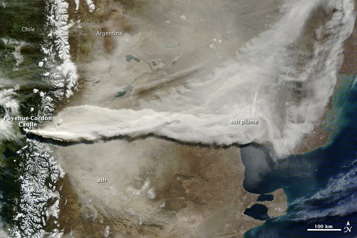
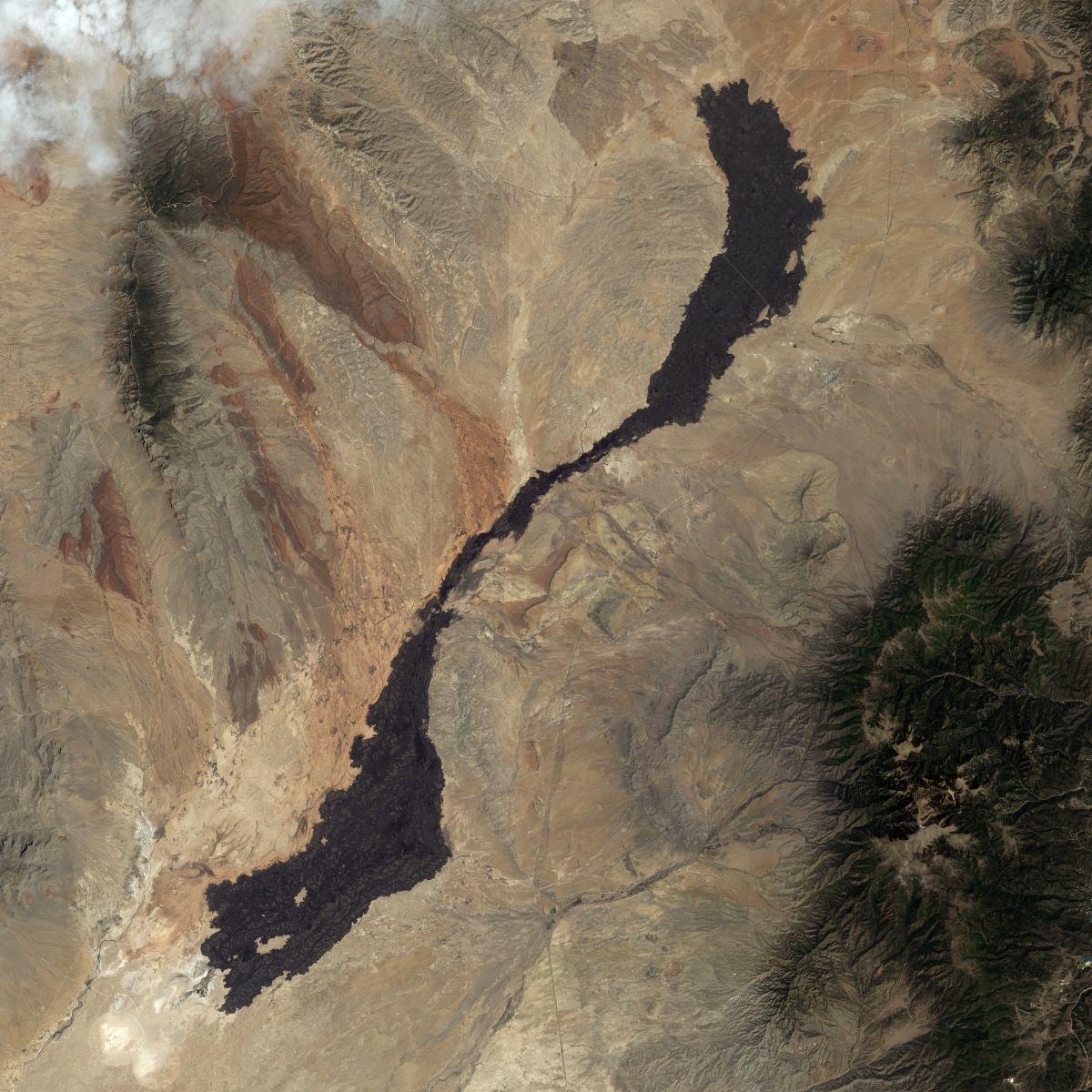
A gigantic plume of ash from the Puyehue-Cordón Volcano in Chile spreads across South America. This image was taken on June 13, 2011 by the Moderate Resolution Imaging Spectroradiometer (MODIS) on the Terra satellite. Credit: NASA and courtesy Jeff Schmaltz, MODIS Rapid Response Team at NASA GSFC.
[/caption]
An incredible amount of ash is being spewed from the erupting Puyehue-Cordón Volcano Complex in Chile. This image, taken by the Moderate Resolution Imaging Spectroradiometer (MODIS) on the Terra satellite on June 13, 2011, shows a large plume of volcanic ash blowing about 780 kilometers east and then northeast over Argentina. A plume of volcanic ash from this eruption disrupted air traffic as far away as New Zealand on June 13. See images below of how far the ash has traveled in the atmosphere, a half a world away.
The Moderate Resolution Imaging Spectroradiometer (MODIS) on the Aqua satellite acquired the two images below of the Chilean ash plume on June 13, 2011 showing that a concentrated plume was visible more than half a world away. The first image shows the ash plume over southern Australia and the Tasman Sea, while the second image provides a view farther east over New Zealand and the South Pacific Ocean.
The Chilean ash plume over southern Australia and the Tasman Sea on June 13, 2011. Credit: NASA/MODIS on the Aqua Satellite.The Chilean volcano ash plume over NewZealand and the South Pacific Ocean. Credit: NASA/MODIS on the Aqua satellite.
NASA’s Earth Observatory website says that although the intensity of the eruption has decreased since the initial eruption, the volcano’s activity is holding steady. The plume reached between 4 and 8 kilometers in altitude on June 13, its height varying with the intensity of the eruptive episode throughout the day.
Here’s how the volcano looked back on June 4, 2011 when it began spewing ash 45,000 feet (14,000 meters) into the air. The Moderate Resolution Imaging Spectroradiometer (MODIS) on the Aqua satellite captured this natural-color image shortly after the eruption began:
Chile’s Puyehue-Cordón Caulle volcano on June 4, 2011. Credit: NASA/Aqua - MODIS
You can follow Universe Today senior editor Nancy Atkinson on Twitter: @Nancy_A. Follow Universe Today for the latest space and astronomy news on Twitter @universetoday and on Facebook.
The Halema’uma’u Crater on the summit of Kilauea Volcano in Hawaii, on January 14, 2011. Image: Nancy Atkinson
[/caption]
Today, NASA’s Earth Observatory website featured an image of activity on the Kilauea Volcano in Hawaii. The image was personally exciting for me to see — not only because I find volcanoes fascinating — but because the day before the satellite image was taken (below) I was flying directly over Kilauea in a helicopter, searching for active lava flows.
Above is an image I took of Halema’uma’u Crater on the summit of Kilauea Volcano, which has been steadily emitting a plume of sulfur dioxide and other volcanic gases for several years. We did not see active flows here, but about 120 meters (390 feet) below the pit’s opening there is a lava pond that rises and falls as magma moves underneath Kilauea. See more of my images below, where we did find some active lava flows and lots of gas emitting from the surrounding region.
Activity at Kilauea, as seen from orbit by the Advanced Land Imager Instrument on the Earth Observing 1 satellite. Credit: NASAAnother view of the Halema’uma’u Crater on the summit of Kilauea Volcano. Image: Nancy Atkinson
Kilauea is the youngest and southeastern most volcano on the Big Island of Hawaii. It started erupting in 1983 and has been active ever since.
Another active caldera in the Kilauea region is the Pu`u `O`o Crater. Image: Nancy Atkinson
East of the summit of Kilauea is another active area, the Pu`u `O`o Crater. On January 14, we saw gas fuming throughout the crater.
Another view of the Pu`u `O`o Crater on January 14, 2011. Image: Nancy AtkinsonOne area of active lava in the Kilauea region. Image: Nancy Atkinson
We did find one crater with active orange magma bubbling underneath the grey, hardened lava. It is a little hard to make out in the image above, as there is some glare from the helicopter window, but there are a couple of small areas of orange tint, and that is the active lava. It wasn’t much, but it was exciting to see.
We did see lots of areas of sulfur dioxide gas venting from the Kilauea region, as in the two images below. According to the USGS Hawaiian Volcano Observatory, sulfur dioxide emission rates from the summit and east rift zone vents have elevated the past few month.
Sulfur dioxide vents on Kilauea. Image: Nancy AtkinsonMore sulfur dioxide vents at Kilauea. Image: Nancy AtkinsonLook closely for steam from lava flowing into the ocean. Image: Nancy Atkinson
We did see a small lava flow going into the ocean. Mostly, we just saw the steam rising as the lava made contact with the cold ocean water, but every once in a while we could see an orange glow on the shore, and as fast as I clicked my camera, unfortunately I never caught the orange glow, just the steam.
I can highly recommend the Big Island of Hawaii as a travel destination, as within its 10,432 square km (4,028 square miles) you can find all but two of the world’s climate zones and see everything from lush rain forests to volcanic deserts, to snow-capped mountains to black and white sandy beaches. You can drive around the entire island in 6 and a half hours, or in 2 hours in a helicopter see the entire island by air.
Merapi Volcano on November 10, 2010, when the Moderate Resolution Imaging Spectroradiometer (MODIS) on NASA’s Terra satellite. Credit: NASA
[/caption]
For about three weeks, Indonesia’s Mount Merapi has been belching out lava, as well as ash and gas, clouding the atmosphere above. This satellite image, taken by NASA’s MODIS instrument on the Terra satellite, shows the volcano now settling down and is the most cloud-free satellite view of the volcano that we’ve been able to see. Thick ash is still rising and the volcano is still considered to be erupting at dangerous levels. Merapi is one of Indonesia’s most active volcanoes, and this eruption has been the most violent since the 1870’s.
The dark brown streak down the southern face of the volcano is ash and other volcanic material deposited by a pyroclastic flow or lahar. The volcano has been blamed for 156 deaths and about 200,000 people had to evacuate. The ash also caused flights to be delayed or canceled.
See below for a thermal image of the lava flow.
The Advanced Spaceborne Thermal Emission and Reflection Radiometer (ASTER) on NASA’s Terra satellite captured the thermal signature of hot ash and rock and a glowing lava dome on Mount Merapi on Nov. 1, 2010. Credit: NASA.
As a very active volcano, Merapi poses a constant threat to thousands of people in Indonesia. The Advanced Spaceborne Thermal Emission and Reflection Radiometer (ASTER) on NASA’s Terra satellite captured the thermal signature of hot ash and rock and a glowing lava dome. The thermal data is overlaid on a three-dimensional map of the volcano to show the approximate location of the flow. The three-dimensional data is from a global topographic model created using ASTER stereo observations.
For more information see NASA’s Earth Observatory website.
We all know that the lava is molten rock that is spewed from a volcano. However how hot is lava? The temperature of lava can range anywhere from 700° C to 1200° C. Lava is not really lava until it meets the earth’s crust before that it is known as magma. Magma is the ocean of molten rock that lies beneath the earth’s crust. When it escapes through cracks the earth’s crust it creates volcanoes. The magma that comes out of volcanoes is what we call lava. Lava can be as much 100,000 times as viscous as water.
The different types of lava vary depending on composition and temperature. The three main types of lava are felsic, intermediate, and mafic. There are two types of felsic lava. They are rhyolite and dacite. These types of lava are composed of aluminum, silica, potassium, sodium, calcium, and liquid quartz and feldspar. Felsic lava normally erupts between 650° C to 750° C.
Intermediate lava is the next type of lava. Intermediate lava is also known as andesitic lava. Andesitic lava has lower levels of aluminium and silica. However this kind of lava is richer in magnesium and iron than felsic lava. This kind of lava occurs on steep composite volcanoes like those found in the Andes mountain range. Since andesitic lava has a lower level of aluminum and silica in its composition it is normally hotter with a range of 750-950° C.
The last type of lava is mafic lava or basaltic lava. This is one of the hottest types of lava coming out at temperatures exceed 950 degrees Celsius. This type of lava is rich in iron bearing minerals. This is what accounts for as high temperature. There are also the kinds of mafic lava that are even a hotter than normal basaltic lava. One type is all ultra-mafic lava.
Lava temperature tells us a lot about the different types of lava. Each brings important minerals and nutrients to the surface. So getting a better understanding of lava flows gives a better of the Earth’s composition and how certain minerals came to the surface of the Earth’s crust.
We have written many articles about lava for Universe Today. Here’s an article about the types of lava, and here’s an article about the viscosity of lava.
We’ve all seen pictures of erupting terrestrial volcanoes from space, and even eruptions on Jupiter’s moon Io in the outer solar system, but would it be possible to detect an erupting volcano on an exoplanet? Astronomers say the answer is yes! (with a few caveats)
It’s going to be decades before telescopes will be able to resolve even the crudest surface features of rocky extrasolar planets, so don’t hold your breath for stunning photos of alien volcanoes outside our solar system. But astronomers have already been able to use spectroscopy to detect the composition of exoplanet atmospheres, and a group of theorists at the Harvard-Smithsonian Center for Astrophysics think a similar technique could detect the atmospheric signature of exo-eruptions.
By collecting spectra right before and right after the planet goes behind its star, astronomers can subtract out the star’s spectrum and isolate the signal from the planet’s atmosphere. Once this is done, they can look for evidence of molecules common in volcanic eruptions. Models suggest that sulfur dioxide is the best candidate for detection because volcanoes produce it in huge quantities and it lasts in a planet’s atmosphere for a long time.
Still, it won’t be easy.
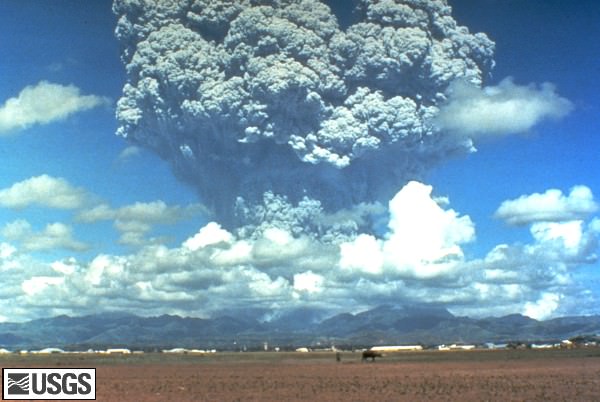
“You would need something truly earthshaking, an eruption that dumped a lot of gases into the atmosphere,” said Smithsonian astronomer Lisa Kaltenegger. “Using the James Webb Space Telescope, we could spot an eruption 10 to 100 times the size of Pinatubo for the closest stars,” she added.
To be detected, exoplanet eruptions would have to be 10 to 100 times larger than the 1991 eruption of Mt. Pinatubo shown here. Image source: USGS
In 1991 Mount Pinatubo in the Philippines belched 17 million tons of sulfur dioxide into the stratosphere. Volcanic eruptions are ranked using the Volcanic Explosivity Index (VEI). Pinatubo ranked ‘colossal’ (VEI of 6) and the largest eruption in recorded history was the ‘super-colossal’ Tambora event in 1815. With a VEI of 7 it was about 10 times as large as Pinatubo. Even larger eruptions (more than 100 times larger than Pinatubo) on Earth are not unheard of: geologic evidence suggests that there have been 47 such eruptions in the past 36 million years, including the eruption of the Yellowstone caldera about 600,000 years ago.
The best candidates for detecting extrasolar volcanoes are super-earths orbiting nearby, dim stars, but the Kaltenegger and her colleagues found that volcanic gases on any earth-like planet up to 30 light years away might be detectable. Now they just have to wait until the James Webb Space Telescope is launched 2014 to test their prediction.
Mt. Cleveland in Alaska. NASA Earth Observatory image by Jesse Allen & Robert Simmon, using data from the NASA/GSFC/METI/ERSDAC/JAROS, and U.S./Japan ASTER Science Team.
[/caption]
You like volcanoes? We’ve got volcanoes! Three recent images from space show some tremendous volcanoes on Earth. This very unusual image shows a small volcanic plume rising above remote Mount Cleveland on June 1, 2010. The snow-covered upper slopes of the Aleutian alaska volcano were also marked by dark debris flow deposits (descending to the east) and ash fall to the south of the summit. This false-color image was acquired by the Advanced Spaceborne Thermal Emission and Reflection Radiometer (ASTER) aboard NASA’s Terra satellite. Snow is white, clouds are pink, vegetation is red, and water is almost black. The Alaska Volcano Observatory reported an ash emission above Mount Cleveland no higher than 16,000 feet (4,900 meters) on May 30th. Mount Cleveland is frequently restless, and the current activity is not unusual, but Ash from Cleveland could threaten flights between Asia and North America. Satellites are the best way to monitor the volcano, which is about 900 miles (1,500 kilometers) from Anchorage.
Mt. Fuji in Japan, as seen from the ISS. Credit: NASA/JAXA/Soichi Noguchi
Before he left the International Space Station to return back to Earth, Soichi Noguchi, who shared his experiences in space like no other astronaut via his Twitter feed and pictures, took this image of Mt. Fuji in his home country of Japan.
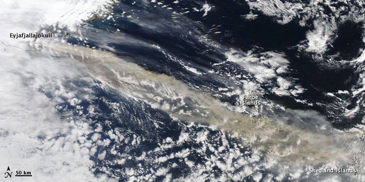
Iceland, without ash and smoke from the Eyjafjallajokull volcano. Credit: ESA
Ok, this one isn’t specifically of a volcano, but it is one of the first satellite images of Iceland to show smoke- and ash-free skies above Iceland.
This image is from ESA’s Envisat satellite and the Medium Resolution Imaging Spectrometer on May 24, 2010.
The Eyjafjallajokull volcano, which had a series of eruptions in April and May, is visible in the dark area on the southern coast. The Vatnajokull glacier (visible in white northeast of Eyjafjallajokull) is the largest in Iceland and in Europe. The white circular patch in the center of the country is Hofsjokull, the country’s third largest glacier and its largest active volcano. The elongated white area west of Hofsjokull is Langjokull, Iceland’s second largest glacier.
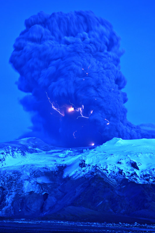
Lightning visible in the plume of the Eyjafjallajokull volcano in Iceland on April 17, 2010. Image courtesy of Snaevarr Gudmundsson.
[/caption]
Astronomer Snaevarr Gudmundsson from Iceland was able to travel to within just a few kilometers from the Eyjafjallajokull volcano, and shared his incredible close-up images with Universe Today. “I stayed near the volcano from about 16:00 hours to 22:00 hours on Saturday and watched its impressive eruption,” Gudmundsson said in an email to me. “Amazing event, awesome explosions of 1200 °C hot magma reaching ice and water. I shot more than 550 images during these hours of continuous enjoyment. Sounds ridiculous but its ever changing appearance was never boring.”
The massive plume put on an impressive display – from lightning forming within the plume to an incredible amount of spewing ash. On one of following pictures you can see helicopter for size comparison of the plume
The massive plume of Eyjafjallajokull volcano dwarfs a helicopter flying nearby (upper left). Image courtesy of and copyright Snaevarr Gudmundsson.
Gudmundsson said he and other photographers were a safe distance from the eruption, but were a few kilometers away. “Nearby was a small river and its prominent sound prevented us from hearing much in the eruption itself except a loud roar from thunders from time to time,” he said. “During daylight we even glimpsed some lightning but at dusk (the photo is taken at about 22:00 in the evening) they were easily spotted especially during active periods of explosions.”
The plume of Eyjafjallajokull volcano on April 17, 2010. Image courtesy of and copyright Snaevarr Gudmundsson.
I asked if there was any smell associated with the Iceland volcano and Gudmundsson said there was a bit of sulphuric smell in the air even though they were in a location where the wind was blowing towards the volcano. “The ash went to the other side of the volcano, as you can suggest, making life miserable for farmers and households below, but the rest of it climbed to higher altitude and from there to Europe.”
“From the foot of the volcano to the prominent top, seen in front of the tephra cloud (seen on some of the photos) the overall height is about 1300 -1400 m,” Gudmundsson said. “When the eruption began a huge flood went down beneath the obvious glacier to the left from the crater. And if you look closely on the photo showing the foot hills under the mountain a lot of icebergs can be seen on the flood plain. Under that same glacier was a rather deep lagoon (can’t been seen but sat between the two high moraines on either side of it, in front of the glacier) but sediment from the eruption filled it up in only two days at most! That is unbelievable. I have climbed this glacier many times but to approach it one usually must traverse the moraine, around the lagoon to reach the ice. But suddenly it is gone.” Another view of Eyjafjallajokull volcano on April 17, 2010. Image courtesy of and copyright Snaevarr Gudmundsson.
Gudmundsson said the flood paths can be seen below the glacier as a narrow gorges carved into rather soft volcanic sediment.
Some of the latest reports from Iceland say that in some areas the volcanic fallout has been significant, clogging car engines, turning grass grey and reducing visibility to just a few meters.
The police say driving conditions can be very difficult in these places, but the area affected is remote with only a few hundred people, most of them living in isolated homes and many of them farmers. They have been advised to stay inside with the windows and doors shut and if they do venture out to wear goggles and a mask.
The staff of Landhelgisgæslan (Icelandic Coastal Patrol) captured this radar image of the craters in Eyjafjallajökull on Friday. There are three main openings and each one is 200-500m in diameter.
Radar image of the volcano, taken by the Icelandic Coastal Patrol.
Our very special thanks to Snaevarr Gudmundsson for sharing his images and experiences of seeing the volcano “up close and personal.” Also thanks to Col Maybury of radio station 2NUR in Newcastle, Australia for connecting me with Snaevarr (yes my connection to Iceland came through Australia!) and also thanks to erlinger on Twitter for help with Icelandic translations of news reports.
NASA's Terra Satellite captured this image on April 15, 2010 of the volcano and resulting ash plume. NASA image by Jeff Schmaltz, MODIS Rapid Response Team at NASA GSFC.
A volcano under a glacier in Iceland erupted Wednesday, melting ice, shooting smoke and steam into the air and forcing hundreds of people to leave their homes. The resulting ash plume has also halted air traffic over much of Europe. Scientists said the eruption under the ice cap was 10 to 20 times more powerful than an eruption from the that happened from the Eyjafjallajokullin Volcano late last month. “This is a very much more violent eruption because it’s interacting with ice and water,” said Andy Russell, an expert in glacial flooding at the University of Newcastle in northern England, in an article on the CBC website. The dramatic footage in the video here was released today, April 15, and satellite images, below, show how far the ash plume has traveled.
[/caption]
The iceland volcano sent a plume of ash and steam across the North Atlantic prompting airspace closures in the United Kingdom, Ireland, France, and Scandinavia, which then had a ripple effect, disrupting flights to and from other countries as well. Authorities could not say how long the airspace closure would last, and the ash’s spread threatened to force closures of additional airspace over the coming days.
NASA's EO-1 Satellite took this image on April 1, 2010. NASA image by Robert Simmon, using ALI data from the EO-1 team
This natural-color satellite image shows the area of the eruption on April 1, when a new vent opened up. The image was acquired by the Advanced Land Imager (ALI) aboard NASA’s Earth Observing-1 (EO-1) satellite.
The volcano, about 120 kilometres east of Reykjavik, erupted March 20 after almost 200 years of silence.
Pall Einarsson, a geophysicist at the University of Iceland, said magma was melting a hole in the thick ice covering the volcano’s crater, sending water coursing down the glacier, and causing widespread flooding.
Iceland’s main coastal ring road was closed near the volcano, and workers smashed a hole in the highway in a bid to give the rushing water a clear route to the coast and prevent a major bridge from being swept away.
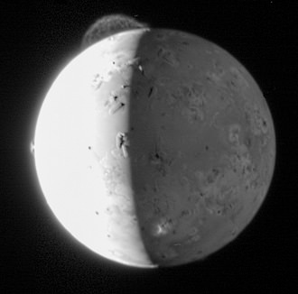
An active volcano on Io, taken by the New Horizons spacecraft. Credit: NASA
Volcanoes are ruptures or fissures in the earth’s crust which leak lava. Although people think of a typical volcano as a cone-shaped one, volcanoes come in many different forms. Ancient civilizations used to associate volcanic eruptions with the actions of gods or other supernatural incidents.
Volcanoes occur most often in particular areas – where tectonic plates converge and diverge – due to the way that volcanoes form. However, they can also be found where the Earth’s crust is thinner, which makes it easier for an opening to form in the crust. The Ring of Fire in the Pacific Ocean is a good example of an area of converging tectonic plates where many volcanoes have formed.
There are a number of different types of volcanoes including fissure vents, shield volcanoes, composite volcanoes, supervolcanoes, and lava domes. Volcanoes erupt in different ways and have various types of lava. A supervolcano, a term coined to refer to a very large volcano, is defined as a volcano that ejects material more than 1,000 cubic kilometers around it. There has not been a supervolcano eruption for over 70,000 years, and the erup53tion of one would cause damage on a massive scale affecting a large region.
Volcanoes can be found both under the ocean – submarine volcanoes – and underneath icecaps – subglacial volcanoes. Submarine volcanoes can become so large that they break the surface and become islands. The Hawaiian Islands started out as submarine volcanoes. The lava that flows underneath the icecaps ends up flowing horizontally, which creates a flat mountain.
Volcanoes are not simply considered active or extinct. If a volcano has erupted recently it is active; some scientists define recently as within a period of thousands of years. If a volcano has not erupted in a while it is dormant. Dormant volcanoes are sometimes mistaken for extinct volcanoes because they can go such a long time without erupting. Normally, scientists do not consider a volcano extinct until it no longer has a lava supply.
There are also volcanoes on other planets and satellites, although most of them are not active. The only celestial bodies with active volcanoes are the Earth, Jupiter’s moon Io, Neptune’s satellite Triton, and Saturn’s moon Enceladus. Io is the most volcanically active place in the Solar System. Scientists believe that there are currently more than 400 active volcanoes on the satellite. The large amount of volcanic activity on the moon is due to the satellite’s eccentric orbit which causes tidal heating. Tidal heating is where one celestial object is heated by the effect of the gravitational pull of another celestial body.
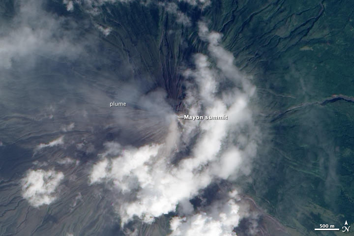
Satellite image of Mayon Volcano in the Phillipines from Dec. 28, 2009.
[/caption]
Mayon Volcano, on the Philippine island of Luzon, has been exhibiting activity suggesting a major eruption is imminent. Described as an “intense level of unrest” by the Philippine Institute of Volcanology and Seismology, Mayon exhibited 7 ash explosions, dozens of earthquakes related to the movement of magma beneath the volcano, over 100 rock falls from the summit, and 3 active lava flows. The Philippine government is enforcing evacuations in a danger zone extending 7 kilometers (4 miles) north and 8 kilometers (5 miles) south of the summit. Tens of thousands of people living within the danger zone (up to 8 kilometers away) of Mayon Volcano in the Philippines were forced to evacuate to emergency shelters in mid-December 2009.
The satellite image above shows Mayon emitting a thin volcanic plume on Dec. 28. Ash obscures the summit crater and clouds hide lava flows on the volcano’s flanks. The natural-color image was acquired by the Advanced Land Imager (ALI) aboard the NASA Earth Observing-1 (EO-1) satellite.
Below, the image from Dec. 15 shows how close a major populated area is to the volcano. Mayon Volcano on Dec. 15, 2009.
The volcano has been noticeably active for several weeks, and officials say “magma is close to the crater and hazardous explosive eruption is imminent.”


 on NASA’s Terra satellite captured the thermal signature of hot ash and rock and a glowing lava dome on Mount Merapi on Nov. 1, 2010. Credit: NASA.")


. Image courtesy of and copyright Snaevarr Gudmundsson.")