The Waters Of Mars: New Map Shows Something Unexpected

A portion of a 2014 Mars map showing the area east of Hellas basin, at midsoutherly latitudes. Credit: USGS

Where did the water on Mars come from, and where did it go? This plot (sort of) formed the basis of one of the best Doctor Who episodes of the modern era, but in all seriousness, it is also driving scientists to examine the Red Planet over and over again.

This means revisiting older information with newer data to see if everything still matches up. From time to time, it doesn’t. The latest example came when scientists at the U.S. Geological Survey created a map of the canyon systems of Waikato Vallis and Reull Vallis, which are in the midsoutherly latitudes of Mars.

They previously believed the canyons were connected, but updating the data from an understanding based on 1980s Viking data revealed a different story.

“These canyons are believed to have formed when underground water was released from plains materials to the surface, causing the ground to collapse. The water could have been stored within the plains in localized aquifers or as ice, which could have melted due to the heat from nearby volcanoes,” the U.S. Geological Survey stated.

Part of the floor of Reull Vallis, a valley east of Hellas Basin on Mars. Picture taken by Mars Global Surveyor. Credit: NASA/JPL/Malin Space Science Systems

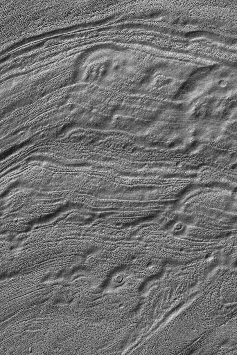
But the newer data — looking at information from the Mars Reconnaissance Orbiter, Mars Odyssey, Mars Global Surveyor — revealed the canyons are quite separate, demarcated by a zone called Eridania Planitia in between.

“Careful estimates of the ages of the canyons and the plains reveal a sequence of events starting with the water released from Waikato Vallis, which would have been stored for a time in the plains as a shallow lake. As Reull Vallis was forming separately, the canyon breached a crater rim that was holding back the water in the lake; the lake drained gradually, which can be seen by many smaller channels incised on the floor of Reull Vallis.”

The map was co-produced by Scott Mest and David Crown, who are both of the Planetary Science Institute. You can view the entire map and related materials here.

Source: Planetary Science Institute

Here’s How You Can Download The Earth In High-Resolution

Artist's conception of Landsat 8 (renamed from Landsat Data Continuity Mission). Credit: NASA/ Goddard/Conceptual Image Lab

Landsat 8 officially opened its eyes to Earth yesterday (May 30). Officials are promising the clearest views yet of the four-decade-old Landsat program, and luckily for people who love amazing Earth views, the images Landsat produces are free.

Before talking a bit about Landsat 8, here’s one way you can find the images: go to this website of raw Landsat data from the United States Geological Survey. In the menu tab “Collection”, go down to “Landsat Archive” and select “Landsat 8 OLI.” Then click a location on the map to see if it’s taken a picture of a spot you’re interested in.

Once you’ve selected it, hit “Add Scene”, then click on the scene list at the bottom right of the screen to download the product. (We’d strongly advise consulting the tutorial on that website for more help. You need to register as a user to download the high-resolution images.)

There isn’t much to see there yet, but over the next few months there should be a wealth of pictures to choose from. More spots where Landsat 8 data will appear are listed on this USGS page.

You may better recall Landsat 8 as the Landsat Data Continuity Mission. Launched on Feb. 11, it was first under the operational control of NASA as the agency put the satellite through its paces — placing it into the proper orbit (it circles in a near-polar orbit) and taking some test images of the planet, for example.

Now that the satellite is ready, the USGS has operational control and will add that to more than 40 years of data collected under the Landsat program. The aim, we assure you, is not just for pretty pictures.

An  Atlas-V rocket with the Landsat Data Continuity Mission (LDCM) spacecraft onboard is seen as it launches on Monday, Feb. 11, 2013 at Vandenberg Air Force Base, California. Credit: NASA
An Atlas-V rocket with the Landsat Data Continuity Mission (LDCM) spacecraft onboard is seen as it launches on Monday, Feb. 11, 2013 at Vandenberg Air Force Base, California. Credit: NASA

Long Earth observation programs show changes in the land over time. We can see cities grow, observe forests shrink or deserts expand in response to human activity or climate change, and also gauge the impact of natural disasters. In the past, Landsat pictures have been used to map the impact of the Mount St. Helen’s eruption of 1980, and to respond to oil gas fires set in Kuwait during the Gulf War of 1991.

These are heavyweight satellites. The truck-sized Landsat 8 weighs 4,566 lbs (2,071 kg) fully loaded with fuel, excluding the weight of the instruments. Its operational land imager can take pictures in nine spectral bands, which is important because certain types of vegetation or land features show up better in different light spectra. (One application is to monitor the health of certain kind of plants in farmer fields, for example.) It also has two thermal infrared sensor bands that will show the heat signature of Earthly features.

For Landsat, officials needed to launch this satellite because its predecessor (Landsat 7)’s operational lifetime is in overtime. Should the satellite have failed before Landsat 8 arrived, 41 years of continuous Earth observations under the same program would have ceased.

Landsat 8 will circle the globe 14 times daily, will repeat its ground track every 16 days, and is expected to do this for at least five years. Check out this USGS feature story for more on how it will contribute to Earth observation.

Timeline showing lifespans of the Landsat satellites. Credit: NASA