While it’s true that there’s no air to carry sound in space, starship explosions would be strangely silent and no one can hear you scream, this latest Science @ NASA video reminds us that “space can make music, if you know how to listen.”
And the “how” in this case is with the Plasma Wave Science Experiment aboard the Voyager 1 spacecraft, which is now playing the sounds of interstellar space — with a little help from University of Iowa physics professor and experiment principal investigator Don Gurnett. Watch the video above for a front-row seat (and read more about Voyager’s historic crossing of the heliosphere here.)
Here’s your amazing oh-my-gosh-space-is-so-cool video of the day — a “canyon of fire” forming on the Sun after the liftoff and detachment of an enormous filament on September 29-30. A new video, created from images captured by the Solar Dynamics Observatory (SDO) and assembled by NASA’s Goddard Space Flight Center, shows the entire dramatic event unfolding in all its mesmerizing magnetic glory.
Watch it below:
Solarrific! (And I highly suggest full-screening it in HD.) That filament was 200,000 miles long, and the rift that formed afterwards was well over a dozen Earths wide!
Captured in various wavelengths of light by SDO’s Atmospheric Imaging Assembly (AIA) the video shows the solar schism in different layers of the Sun’s corona, which varies greatly in temperature at different altitudes.
According to the description from Karen Fox at GSFC:
“The red images shown in the movie help highlight plasma at temperatures of 90,000° F and are good for observing filaments as they form and erupt. The yellow images, showing temperatures at 1,000,000° F, are useful for observing material coursing along the sun’s magnetic field lines, seen in the movie as an arcade of loops across the area of the eruption. The browner images at the beginning of the movie show material at temperatures of 1,800,000° F, and it is here where the canyon of fire imagery is most obvious.”
Now, there’s not really any “fire” on the Sun — that’s just an illustrative term. What we’re actually seeing here is plasma contained by powerful magnetic fields that constantly twist and churn across the Sun’s surface and well up from its interior. The Sun is boiling with magnetic fields, and when particularly large ones erupt from deep below its surface we get the features we see as sunspots, filaments, and prominences.
When those fields break, the plasma they contained gets blasted out into space as coronal mass ejections… and this is what typically happens when one hits Earth. (But it could be much worse.)
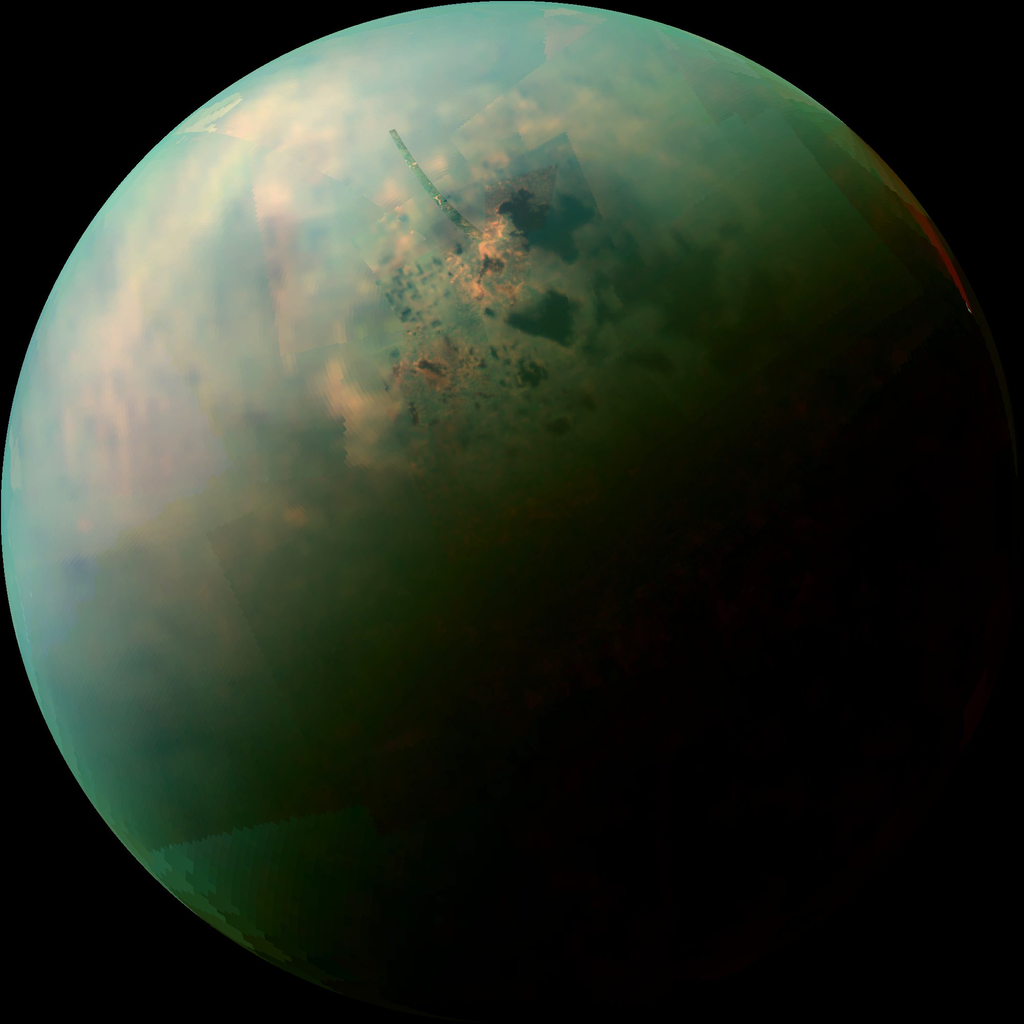
Titan's north pole is home to many methane lakes. Credit: NASA
A combination of exceptionally clear weather, the steady approach of northern summer, and a poleward orbital path has given Cassini — and Cassini scientists — unprecedented views of countless lakes scattered across Titan’s north polar region. In the near-infrared mosaic above they can be seen as dark splotches and speckles scattered around the moon’s north pole. Previously observed mainly via radar, these are the best visual and infrared wavelength images ever obtained of Titan’s northern “land o’ lakes!”
Titan is currently the only other world besides Earth known to have stable bodies of liquid on its surface, but unlike Earth, Titan’s lakes aren’t filled with water — instead they’re full of liquid methane and ethane, organic compounds which are gases on Earth but liquids in Titan’s incredibly chilly -290º F (-180º C) environment.
While one large lake and a few smaller ones have been previously identified at Titan’s south pole, curiously almost all of Titan’s lakes appear near the moon’s north pole.
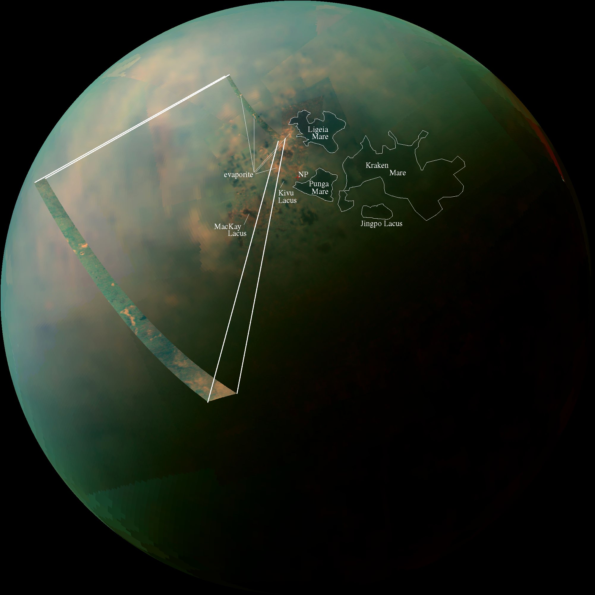
Infrared observations of Titan’s northern lakes. The cross marks Titan’s geographic north pole. (NASA/JPL-Caltech/SSI)
For an idea of scale, the large lake at the upper right above (and the largest lake on Titan) Kraken Mare is comparative in size to the Caspian Sea and Lake Superior combined. Kraken Mare is so large that sunlight was seen reflecting off its surface in 2009. Punga Mare, nearest Titan’s pole, is 240 miles (386 km) across.
Besides revealing the (uncannily) smooth surfaces of lakes — which appear dark in near-infrared wavelengths but would also be darker than the surrounding landscape in visible light — these Cassini images also show an unusually bright terrain surrounding them. Since the majority of Titan’s lakes are found within this bright region it’s thought that there could be a geologic correlation; is this Titan’s version of karst terrain, like what’s found in the southeastern U.S. and New Mexico? Could these lakes be merely the visible surfaces of a vast underground hydrocarbon aquifer? Or are they shallow pools filling depressions in an ancient lava flow?
Annotated infrared mosaic of Titan’s north pole (NASA/JPL-Caltech/SSI)
Or, are they the remains of once-larger lakes and seas which have since evaporated? The orange-hued regions in the false-color mosaic may be evaporite — the Titan equivalent of salt flats on Earth. The evaporated material is thought to be organic chemicals originally from Titan’s haze particles that were once dissolved in liquid methane.
“Is this an indication that with increased warmth, the seas and lakes are starting to evaporate, leaving behind a deposit of organic material,” wrote Carolyn Porco, Cassini Imaging Team Leader, in an email earlier today. “…in other words, the Titan equivalent of a salt-flat?”
The largest lake at Titan’s south pole, Ontario Lacus, has been previously compared to such an ephemeral lake in Namibia called the Etosha Pan. (Read more here.)
These observations are only possible because of the extended and long-term study of Saturn and its family of moons by the Cassini spacecraft, which began with its establishing orbit in 2004 and has since continued across multiple seasons over a third of the ringed planet’s year. The existence of methane lakes on Titan is undoubtedly fascinating, but how deep the lakes are, where they came from and how they behave in Titan’s environment have yet to be discovered. Luckily, the changing season is on our side.
“Titan’s northern lakes region is one of the most Earth-like and intriguing in the solar system,” said Linda Spilker, Cassini project scientist, based at NASA’s Jet Propulsion Laboratory, Pasadena, Calif. “We know lakes here change with the seasons, and Cassini’s long mission at Saturn gives us the opportunity to watch the seasons change at Titan, too. Now that the sun is shining in the north and we have these wonderful views, we can begin to compare the different data sets and tease out what Titan’s lakes are doing near the north pole.”
The images shown above were obtained by Cassini’s visual and infrared mapping spectrometer (VIMS) during a close flyby of Titan on Sept. 12, 2013.
Read more on the Cassini Imaging Central Laboratory for Operations (CICLOPS) site here and on the NASA site here.
“But how thrilling it is to still be uncovering new territory on this fascinating moon… a place that, until Cassini’s arrival at Saturn nearly 10 years ago, was the largest single expanse of unseen terrain we had remaining in our solar system. Our adventures here have been the very essence of exploration. And it’s not over yet!”
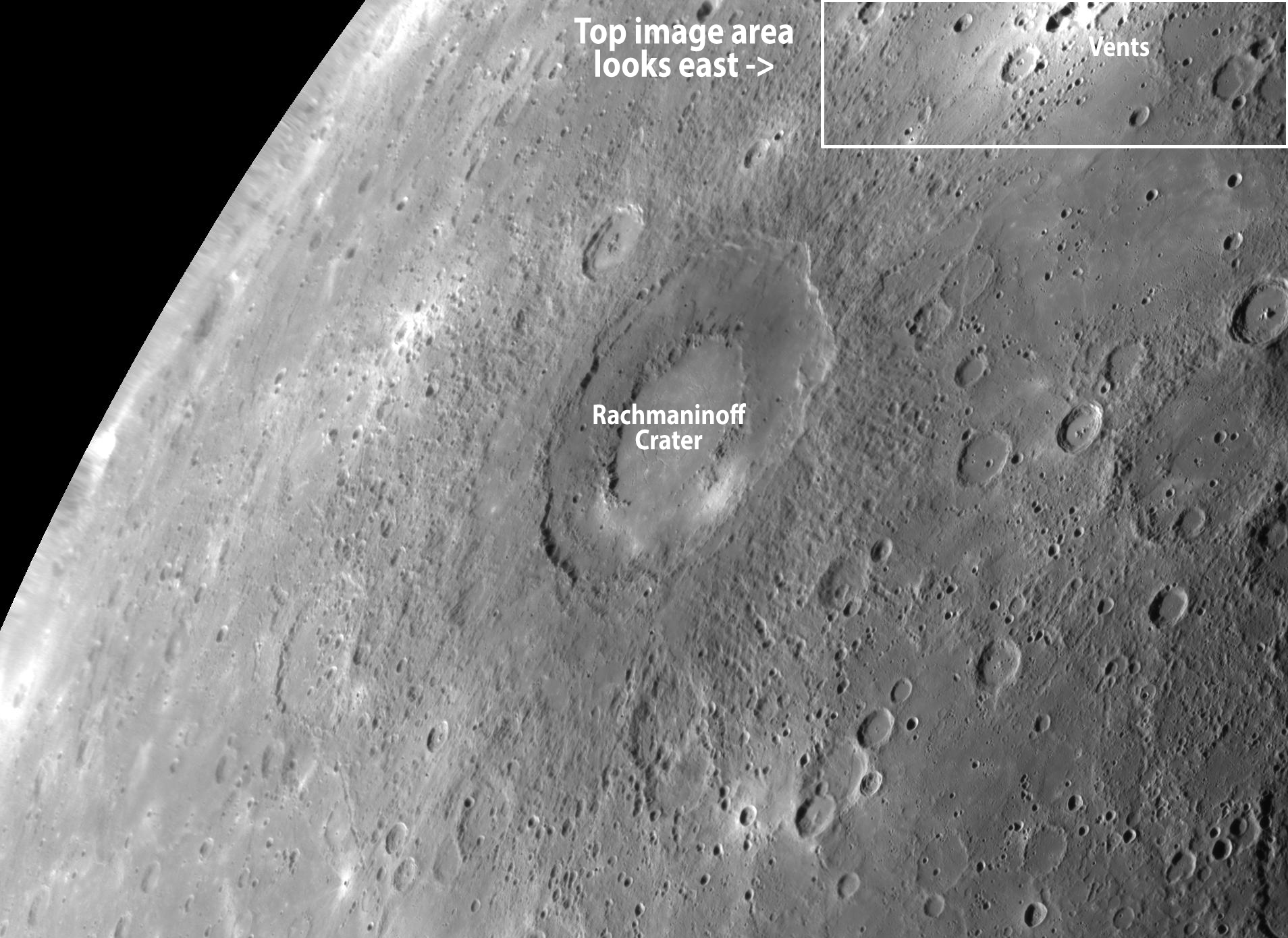
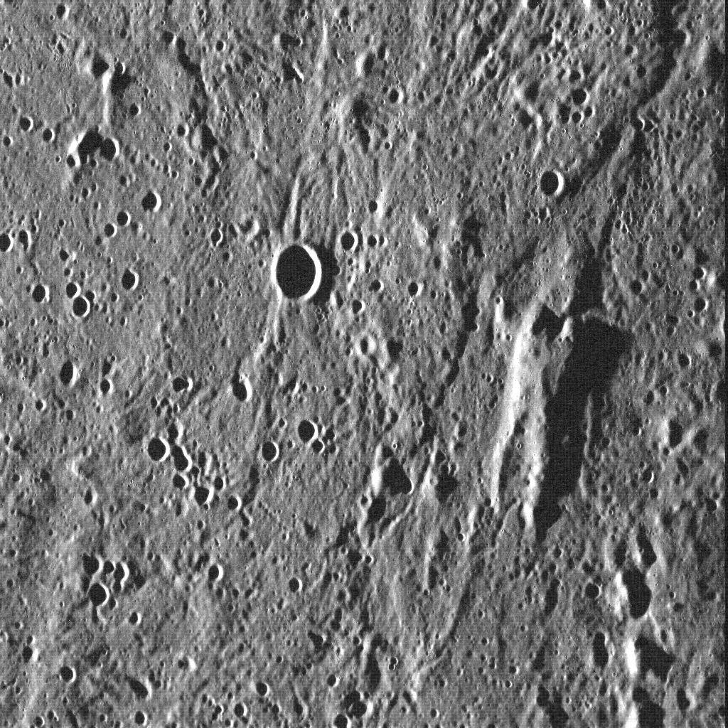
An oblique view of pyroclastic vents on Mercury via MESSENGER
Here on Earth we’re used to seeing volcanoes as towering mountains with steam-belching peaks or enormous fissures oozing lava. But on Mercury volcanic features often take the form of sunken pits surrounded by bright reflective material. They look like craters from orbit but are more irregularly-shaped, and here we have a view from MESSENGER of a cluster of them amidst a rugged landscape that stretches all the way to the planet’s limb.
The image above shows a group of pyroclastic vents on Mercury, located just north and east of the 180-mile (290-km) -wide, double-ringed Rachmaninoff crater. The vents lie in the center of a spread of high-reflectance material, sprayed out by ancient eruptions. This bright blanket of material stands out against Mercury’s surface so well, it has even been spotted in Earth-based observations!
An older vent can be seen at the bottom right, looking like a crater but with non-circular walls. North is to the left.
So why do Mercury’s volcanoes look so different than Earth’s? Planetary scientist David Blewett from Johns Hopkins University Applied Physics Laboratory explains:
“Volcanism on Mercury (and also the Moon) appears to have been dominated by flood lavas, in which large quantities if highly fluid (low-viscosity) magma erupts and flows widely to cover a large area. In this type of eruption, no large ‘volcano’ edifice is constructed,” David wrote in an email. “The lunar maria and many of Mercury’s smooth plains deposits were formed in this manner.”
“On both the Moon and Mercury there are also examples of explosive activity in which eruptions from a vent showered the surroundings with pyroclastic material (volcanic ash),” he added. “The vents and bright pyroclastic halos seen near Rachmaninoff on Mercury are examples, as well as numerous ‘dark mantle deposits’ on the Moon.”
The discovery and investigation of vents like these is extremely valuable to scientists, as they provide information on Mercury’s formation, composition, and the nature of volatiles in its interior. (Plus the oblique angle is very cool! Makes you feel like you’re flying along with MESSENGER over Mercury’s surface.)
See below for a wider view of the region and context of the placement of these vents to Rachmaninoff.
MESSENGER image of Rachmaninoff crater obtained in September 2009
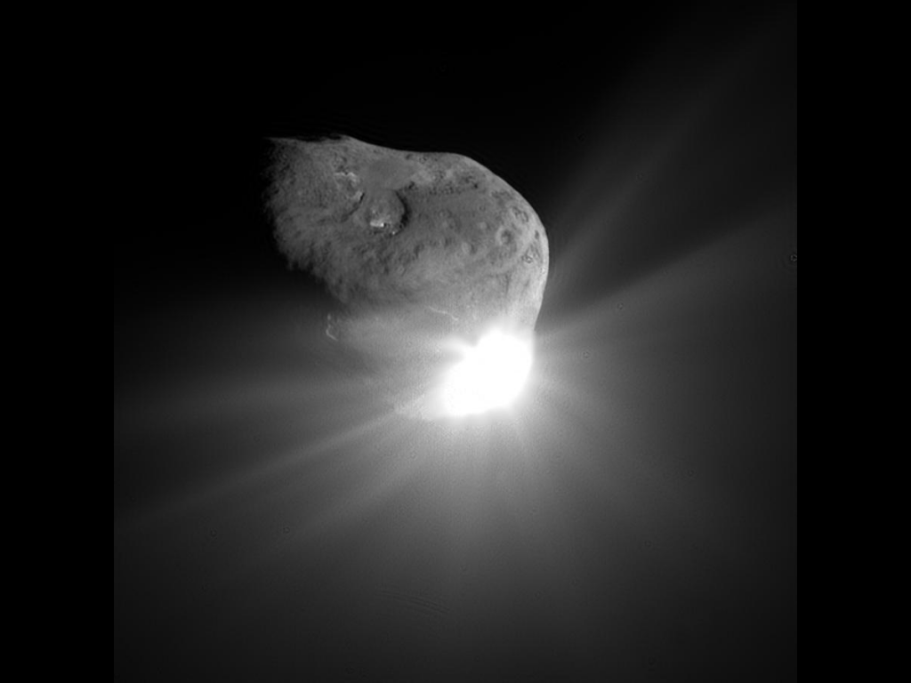
Comet Tempel 1 a minute after being struck by Deep Impact's impactor on July 4, 2005 (NASA/JPL-Caltech/UMD)
After almost 9 years in space that included an unprecedented July 4th impact and subsequent flyby of a comet, an additional comet flyby, and the return of approximately 500,000 images of celestial objects, NASA’s Deep Impact/EPOXI mission has officially been brought to a close.
The project team at NASA’s Jet Propulsion Laboratory has reluctantly pronounced the mission at an end after being unable to communicate with the spacecraft for over a month. The last communication with the probe was Aug. 8. Deep Impact was history’s most traveled comet research mission, having journeyed a total of about 4.7 billion miles (7.58 billion kilometers).
“Deep Impact has been a fantastic, long-lasting spacecraft that has produced far more data than we had planned,” said Mike A’Hearn, the Deep Impact principal investigator at the University of Maryland in College Park. “It has revolutionized our understanding of comets and their activity.”
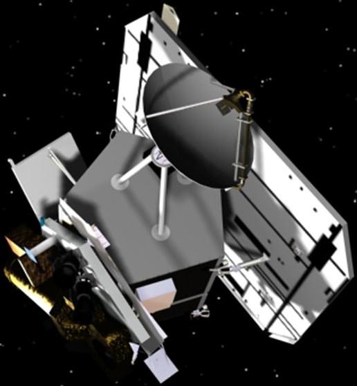
Artist’s rendering of the Deep Impactor flyby spacecraft (NASA)
Launched in January 2005, the spacecraft first traveled about 268 million miles (431 million kilometers) to the vicinity of comet Tempel 1. On July 3, 2005, the spacecraft deployed an impactor into the path of comet to essentially be run over by its nucleus on July 4. This caused material from below the comet’s surface to be blasted out into space where it could be examined by the telescopes and instrumentation of the flyby spacecraft. Sixteen days after that comet encounter, the Deep Impact team placed the spacecraft on a trajectory to fly back past Earth in late December 2007 to put it on course to encounter another comet, Hartley 2 in November 2010, thus beginning the spacecraft’s new EPOXI mission.
“Six months after launch, this spacecraft had already completed its planned mission to study comet Tempel 1,” said Tim Larson, project manager of Deep Impact at JPL. “But the science team kept finding interesting things to do, and through the ingenuity of our mission team and navigators and support of NASA’s Discovery Program, this spacecraft kept it up for more than eight years, producing amazing results all along the way.”
The spacecraft’s extended mission culminated in the successful flyby of comet Hartley 2 on Nov. 4, 2010. Along the way, it also observed six different stars to confirm the motion of planets orbiting them, and took images and data of the Earth, the Moon and Mars. These data helped to confirm the existence of water on the Moon, and attempted to confirm the methane signature in the atmosphere of Mars. One sequence of images is a breathtaking view of the Moon transiting across the face of Earth.
This image of comet ISON C/2012 S1 from NASA’s Deep Impact/EPOXI spacecraft clearly shows the coma and nucleus on Jan. 17 and 18, 2013 beyond the orbit of Jupiter. Credit: NASA.
After losing contact with the spacecraft last month, mission controllers spent several weeks trying to uplink commands to reactivate its onboard systems. Although the exact cause of the loss is not known, analysis has uncovered a potential problem with computer time tagging that could have led to loss of control for Deep Impact’s orientation. That would then affect the positioning of its radio antennas, making communication difficult, as well as its solar arrays, which would in turn prevent the spacecraft from getting power and allow cold temperatures to ruin onboard equipment, essentially freezing its battery and propulsion systems.
Without battery power, the Deep Impact spacecraft is now adrift and silent, spinning out of control through the solar system.
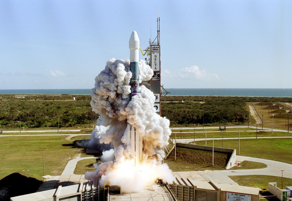
Launch of Deep Impact aboard a Boeing Delta II rocket from Cape Canaveral AFS on Jan. 12, 2005 (NASA)
“Despite this unexpected final curtain call, Deep Impact already achieved much more than ever was envisioned. Deep Impact has completely overturned what we thought we knew about comets and also provided a treasure trove of additional planetary science that will be the source data of research for years to come.”
– Lindley Johnson, Program Executive for the Deep Impact mission
It’s a sad end for a hardworking spacecraft, but over the course of its 8 1/2 years in space Deep Impact provided many significant results for the science community. Here are the top five, according to the mission’s principal investigator Michael A’Hearn.
HiRISE image of lobate landforms called "brain terrain" that wrap around a small hill on Mars
It doesn’t take much thought to understand why this landscape on Mars is called “brain terrain” — the swirling lobes of ice, part of a large glacial deposit in Mars’ northern hemisphere, uncannily resemble the texture of a brain — or at the very least a brain coral!
What causes this strange landscape? Find out below:
It’s suggested that brain terrain is the result of the thermal stress and contraction, followed by sublimation, of these large ice deposits, laid down during a mid-latitude glaciation period ten to 100 million years ago. (Read more in this 2009 paper by Brown University’s Joseph Levy et al.)
This image was obtained by the HiRISE camera aboard the Mars Reconnaissance orbiter on August 23, 2013. See the original RGB color scan here.
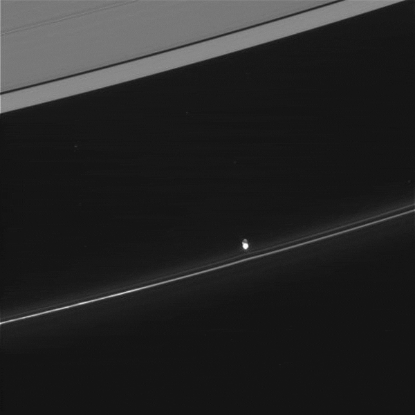
We all know that Saturn’s moon Enceladus has a whole arsenal of geysers jetting a constant spray of ice out into orbit (and if you didn’t know, learn about it here) but Enceladus isn’t the only place in the Saturnian system where jets can be found — there are some miniature versions hiding out in the thin F ring as well!
Watch the 50-mile-wide Prometheus dip into the F ring (CLICK TO PLAY) NASA/JPL/SSI. Animation by J. Major.
The image above, captured by the Cassini spacecraft on June 20, 2013, shows a segment of the thin, ropy F ring that encircles Saturn just beyond the A ring (visible at upper right). The bright barb near the center is what scientists call a mini jet, thought to be caused by small objects getting dragged through the ring material as a result of repeated passings by the shepherd moon Prometheus.
Coincidentally, it’s gravitational perturbations by Prometheus that help form the objects — half-mile-wide snowball-like clusters of icy ring particles — in the first place.
Unlike the dramatic jets on Enceladus, which are powered by tidal stresses that flex the moon’s crust, these mini jets are much more subtle and occur at the casual rate of 4 mph (2 meters/second)… about the speed of a brisk walk.
The reflective jets themselves can be anywhere from 25 to 112 miles (40 to 180 kilometers) long.
See more images of mini jets — also called “classic trails” — below:
Various images of mini jets captured by Cassini from 2005 to 2008.
This elevated rise on Mercury resembles a vaguely humanoid shape
You’ve all heard of the “face on Mars” and the “man in the Moon” — well I guess this would be the “man on Mercury!” And I feel like I’ve seen him somewhere before…
“Oh, they’ve encased him in carbonite. He should be quite well protected.”
In yet another instance of the phenomenon known as pareidolia, it’s hard not to see the vaguely human shape in this image of Mercury’s surface, acquired by the MESSENGER spacecraft in July 2011. But what looks like a person with upraised arms (resembling, the team suggests, a certain carbonite-encased space smuggler) is really an ancient block of surface crust that juts from the floor of Mercury’s vast Caloris basin — likely the remnants of harder material predating the basin-forming impact 3.9 billion years ago. The low angle of sunlight from the west helps to highlight the surface shapes.
The image above shows an area 96 km (59.7 mi.) across.
If Jabba really wanted to keep his favorite wall decoration safe, perhaps he should have put it on Mercury…
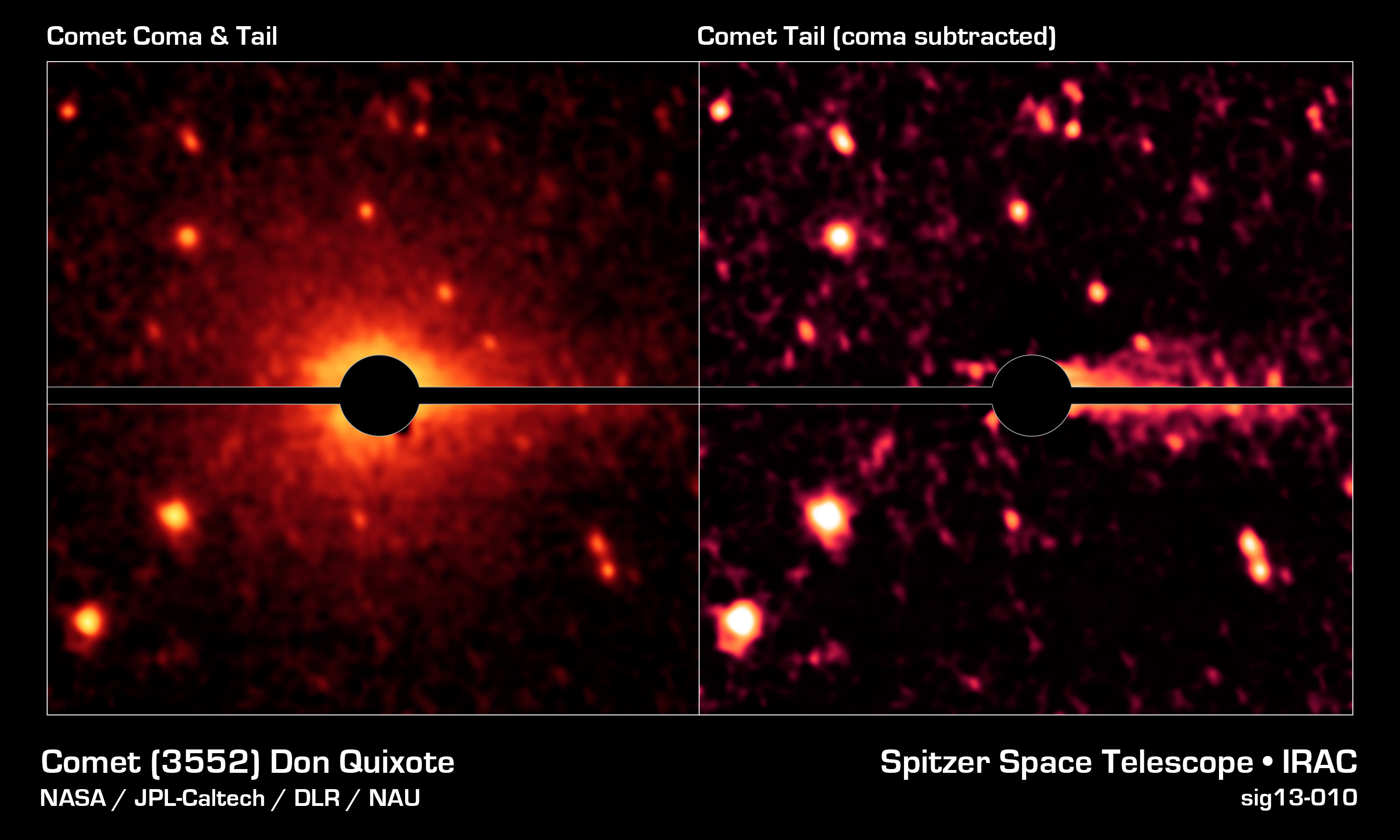
Spitzer image of an asteroid's surprise coma and tail (NASA/JPL-Caltech/DLR/NAU)
It’s a case of mistaken identity: a near-Earth asteroid with a peculiar orbit turns out not to be an asteroid at all, but a comet… and not some Sun-dried burnt-out briquette either but an actual active comet containing rock and dust as well as CO2 and water ice. The discovery not only realizes the true nature of one particular NEO but could also shed new light on the origins of water here on Earth.
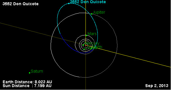
JPL Near-Earth Object database map of 3552 Don Quixote’s orbit
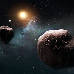
Designated 3552 Don Quixote, the 19-km-wide object is the third largest near-Earth object — mostly rocky asteroids that orbit the Sun in the vicinity of Earth.
According to the IAU, an asteroid is coined a near-Earth object (NEO) when its trajectory brings it within 1.3 AU from the Sun and within 0.3 AU of Earth’s orbit.
About 5 percent of near-Earth asteroids are thought to actually be dead comets. Today an international team including Joshua Emery, assistant professor of earth and planetary sciences at the University of Tennessee, have announced that Don Quixote is neither.
An asteroid is coined a near-Earth object (NEO) when its trajectory brings it within 1.3 AU from the Sun and within 0.3 AU of Earth’s orbit. (IAU)
“Don Quixote has always been recognized as an oddball,” said Emery. “Its orbit brings it close to Earth, but also takes it way out past Jupiter. Such a vast orbit is similar to a comet’s, not an asteroid’s, which tend to be more circular — so people thought it was one that had shed all its ice deposits.”
Using the NASA/JPL Spitzer Space Telescope, the team — led by Michael Mommert of Northern Arizona University — reexamined images of Don Quixote from 2009 when it was at perihelion and found it had a coma and a faint tail.
Emery also reexamined images from 2004, when Quixote was at its farthest distance from the Sun, and determined that the surface is composed of silicate dust, which is similar to comet dust. He also determined that Don Quixote did not have a coma or tail at this distance, which is common for comets because they need the sun’s radiation to form the coma and the sun’s charged particles to form the tail.
The researchers also confirmed Don Quixote’s size and the low, comet-like reflectivity of its surface.
“The power of the Spitzer telescope allowed us to spot the coma and tail, which was not possible using optical telescopes on the ground,” said Emery. “We now think this body contains a lot of ice, including carbon dioxide and/or carbon monoxide ice, rather than just being rocky.”
This discovery implies that carbon dioxide and water ice might be present within other near-Earth asteroids and may also have implications for the origins of water on Earth, as comets are thought to be the source of at least some of it.
The amount of water on Don Quixote is estimated to be about 100 billion tons — roughly the same amount in Lake Tahoe.
“Our observations clearly show the presence of a coma and a tail which we identify as molecular line emission from CO2 and thermal emission from dust. Our discovery indicates that more NEOs may harbor volatiles than previously expected.”
– Mommert et al., “Cometary Activity in Near–Earth Asteroid (3552) Don Quixote “
The findings were presented Sept. 10 at the European Planetary Science Congress 2013 in London.
3552 Quixote isn’t the only asteroid found to exhibit comet-like behavior either — check out Elizabeth Howell’s recent article, “Asteroid vs. Comet: What the Heck is 3200 Phaethon?” for a look at another NEA with cometary aspirations.
The MESSENGER team celebrates 1,000 featured images of the innermost planet!
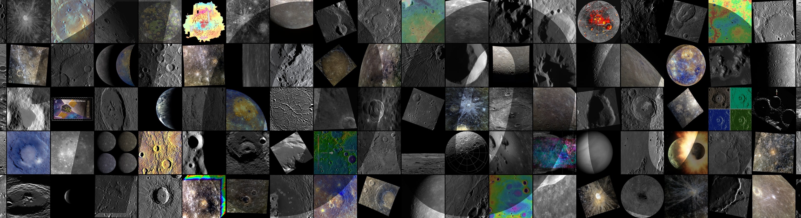
It’s been nearly two and a half years since the NASA-sponsored MESSENGER mission entered orbit around Mercury — the first spacecraft ever to do so — and today the MESSENGER team celebrated the 1,000th featured image on the mission site with a mosaic of discovery highlights, seen above.
“I thought it sensible to produce a collage for the 1,000th web image because of the sheer volume of images the team has already posted, as no single picture could encompass the enormous breadth of Mercury science covered in these postings,” explained MESSENGER Fellow Paul Byrne, of the Carnegie Institution of Washington. “Some of the images represent aspects of Mercury’s geological characteristics, and others are fun extras, such as the U.S. Postal Service’s Mercury stamp. The ‘1,000’ superimposed on the collage is a reminder of the major milestone the team has reached in posting 1,000 featured images — and even a motivation to post 1,000 more.”
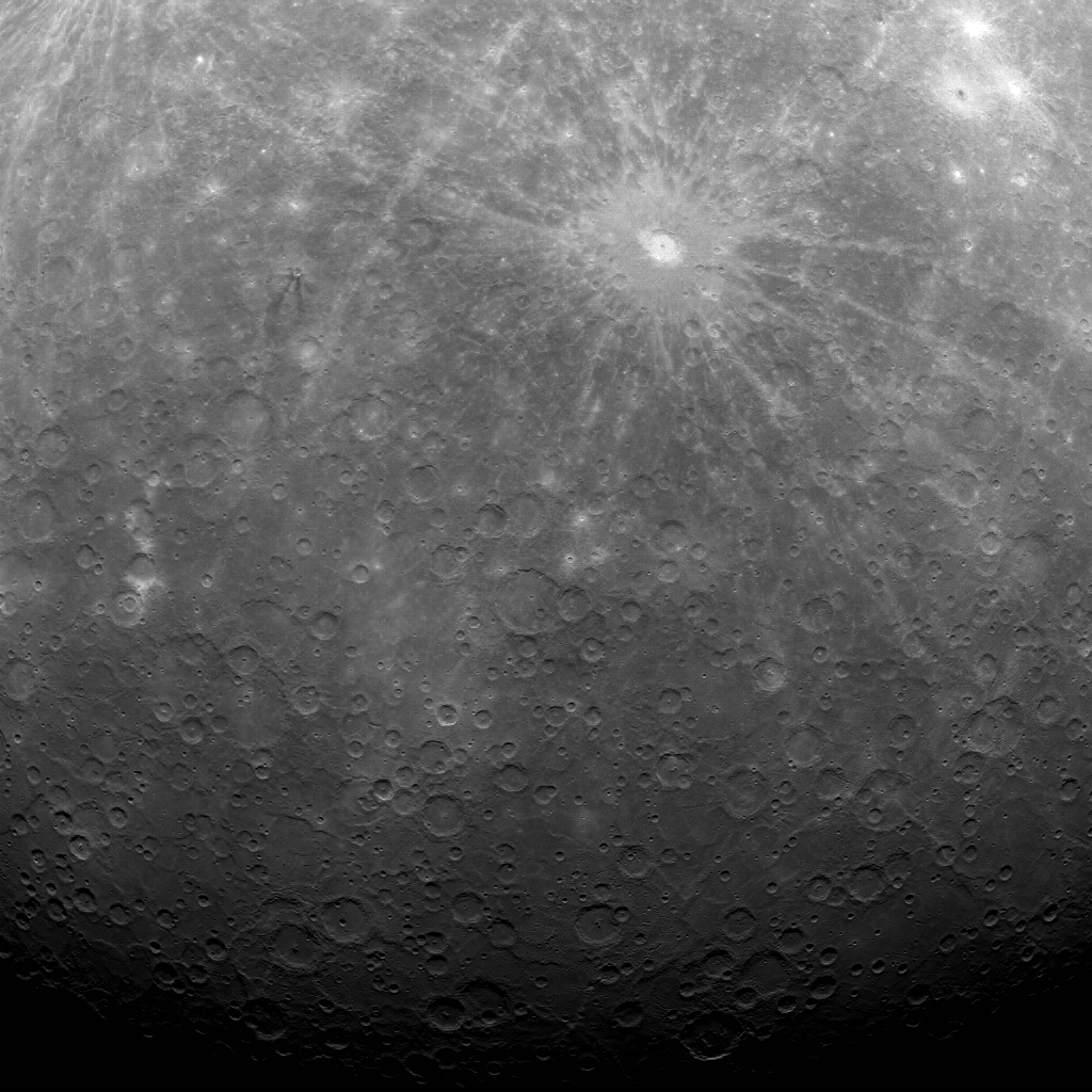
See the very first image MESSENGER obtained from orbit below:
The Mercury Dual Imaging System (MDIS) team has posted a new image to the MESSENGER website approximately once per business day since March 29, 2011, when this first image of Mercury’s surface obtained from orbit was made public.
“During this two-year period, MESSENGER’s daily web image has been a successful mechanism for sharing results from the mission with the public at large,” said Nancy Chabot, MDIS Instrument Scientist at the Johns Hopkins University Applied Physics Laboratory (APL). Chabot has been leading the release of web images since MESSENGER’s first flyby of Mercury in January 2008.
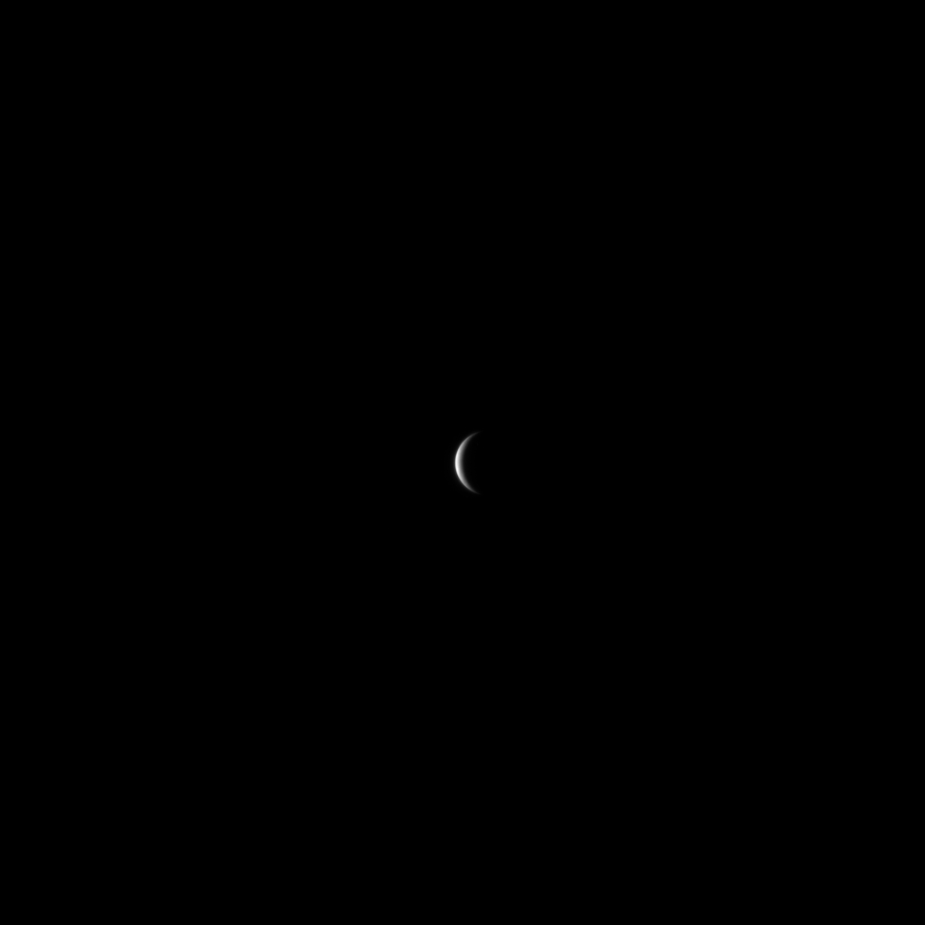
“The first image I released was this one, as MESSENGER approached Mercury for the mission’s first Mercury flyby,” said Chabot. “Mercury was just a small crescent in the image, but it was still very exciting for me. We were obtaining the first spacecraft images of Mercury since Mariner 10 transmitted its final image in 1975, and this was just the beginning of the flood of images that followed.”
One of the first spacecraft images of Mercury since Mariner 10 transmitted its final image in 1975
The herculean effort involved in posting a new image every business day was made possible by a small team of scientists in addition to Chabot and Byrne, including APL’s David Blewett, Brett Denevi, Carolyn Ernst, Rachel Klima, Nori Laslo, and Heather Meyer.
“Creating images and captions for the MESSENGER Image Gallery has been fun and interesting,” Blewett said. “Working on a Gallery release gives me a chance take a break from my regular research and look all around Mercury’s surface for an image that the general public might find to be engaging from a scientific, artistic, or humorous perspective (and sometimes all three!).”
“The posting of the 1,000th image of Mercury on our web gallery is a wonderful benchmark, but there’s much more to come,” adds MESSENGER Principal Investigator Sean Solomon of Columbia University’s Lamont-Doherty Earth Observatory. “MESSENGER’s altitude at closest approach is steadily decreasing, and in a little more than six months our spacecraft will be able to view Mercury at closer range than ever before with each orbit. Stay tuned!”
Image credits: NASA/Johns Hopkins University Applied Physics Laboratory/Carnegie Institution of Washington
MESSENGER (MErcury Surface, Space ENvironment, GEochemistry, and Ranging) is a NASA-sponsored scientific investigation of the planet Mercury and the first space mission designed to orbit the planet closest to the Sun. The MESSENGER spacecraft launched on August 3, 2004, and entered orbit about Mercury on March 17, 2011 (March 18, 2011 UTC).